Metadata Report for BODC Series Reference Number 1336723
Metadata Summary
Problem Reports
Data Access Policy
Narrative Documents
Project Information
Data Activity or Cruise Information
Fixed Station Information
BODC Quality Flags
SeaDataNet Quality Flags
Metadata Summary
Data Description |
|||||||||||||||||||||||||||||||||||||||||||||
|
|||||||||||||||||||||||||||||||||||||||||||||
Data Identifiers |
|||||||||||||||||||||||||||||||||||||||||||||
|
|||||||||||||||||||||||||||||||||||||||||||||
Time Co-ordinates(UT) |
|||||||||||||||||||||||||||||||||||||||||||||
|
|||||||||||||||||||||||||||||||||||||||||||||
Spatial Co-ordinates | |||||||||||||||||||||||||||||||||||||||||||||
|
|||||||||||||||||||||||||||||||||||||||||||||
Parameters |
|||||||||||||||||||||||||||||||||||||||||||||
|
|||||||||||||||||||||||||||||||||||||||||||||
Definition of BOTTFLAG | |||||||||||||||||||||||||||||||||||||||||||||
| BOTTFLAG | Definition |
|---|---|
| 0 | The sampling event occurred without any incident being reported to BODC. |
| 1 | The filter in an in-situ sampling pump physically ruptured during sample resulting in an unquantifiable loss of sampled material. |
| 2 | Analytical evidence (e.g. surface water salinity measured on a sample collected at depth) indicates that the water sample has been contaminated by water from depths other than the depths of sampling. |
| 3 | The feedback indicator on the deck unit reported that the bottle closure command had failed. General Oceanics deck units used on NERC vessels in the 80s and 90s were renowned for reporting misfires when the bottle had been closed. This flag is also suitable for when a trigger command is mistakenly sent to a bottle that has previously been fired. |
| 4 | During the sampling deployment the bottle was fired in an order other than incrementing rosette position. Indicative of the potential for errors in the assignment of bottle firing depth, especially with General Oceanics rosettes. |
| 5 | Water was reported to be escaping from the bottle as the rosette was being recovered. |
| 6 | The bottle seals were observed to be incorrectly seated and the bottle was only part full of water on recovery. |
| 7 | Either the bottle was found to contain no sample on recovery or there was no bottle fitted to the rosette position fired (but SBE35 record may exist). |
| 8 | There is reason to doubt the accuracy of the sampling depth associated with the sample. |
| 9 | The bottle air vent had not been closed prior to deployment giving rise to a risk of sample contamination through leakage. |
Definition of Rank |
|
|
Problem Reports
No Problem Report Found in the Database
Data Access Policy
Open Data supplied by Natural Environment Research Council (NERC)
You must always use the following attribution statement to acknowledge the source of the information: "Contains data supplied by Natural Environment Research Council."
Narrative Documents
Niskin Bottle
The Niskin bottle is a device used by oceanographers to collect subsurface seawater samples. It is a plastic bottle with caps and rubber seals at each end and is deployed with the caps held open, allowing free-flushing of the bottle as it moves through the water column.
Standard Niskin
The standard version of the bottle includes a plastic-coated metal spring or elastic cord running through the interior of the bottle that joins the two caps, and the caps are held open against the spring by plastic lanyards. When the bottle reaches the desired depth the lanyards are released by a pressure-actuated switch, command signal or messenger weight and the caps are forced shut and sealed, trapping the seawater sample.
Lever Action Niskin
The Lever Action Niskin Bottle differs from the standard version, in that the caps are held open during deployment by externally mounted stainless steel springs rather than an internal spring or cord. Lever Action Niskins are recommended for applications where a completely clear sample chamber is critical or for use in deep cold water.
Clean Sampling
A modified version of the standard Niskin bottle has been developed for clean sampling. This is teflon-coated and uses a latex cord to close the caps rather than a metal spring. The clean version of the Levered Action Niskin bottle is also teflon-coated and uses epoxy covered springs in place of the stainless steel springs. These bottles are specifically designed to minimise metal contamination when sampling trace metals.
Deployment
Bottles may be deployed singly clamped to a wire or in groups of up to 48 on a rosette. Standard bottles and Lever Action bottles have a capacity between 1.7 and 30 L. Reversing thermometers may be attached to a spring-loaded disk that rotates through 180° on bottle closure.
Inorganic nutrient discrete samples from CTD bottles during RRS James Cook cruise DY008
Originator's Protocol for Data Acquisition and Analysis
Sampling strategy
Samples were collected from 13 CTD casts at up to eight depth levels. The water sample was transferred from the CTD to 60 ml HDPE Nalgene bottles (acid washed and cleaned) using Silicone tubing, with the sample bottle being washed three times before the final sample was taken. This sample was then immediately taken to the laboratory and analysed as soon as possible after the sample was collected. Gloves and other clean handling protocols were adopted following the GO-SHIP protocols. When immediate analysis was not possible samples were stored in the dark, in a fridge, and brought back to room temperature prior to analysis.
Sample Analysis
The inorganic nutrient samples were analysed using a 5 channel (nitrate, nitrite, phosphate, silicate and ammonium) Bran and Luebbe AAIII segmented flow, colorimetric, autoanalyser. The data were calibrated against home nutrient standards and then compared against Certified Nutrient Reference Materials, from KANSO Technos, Japan.
The analytical chemical methodologies used were according to Brewer and Riley (1965) for nitrate, Grasshoff (1976) for nitrite, Kirkwood (1989) for phosphate and silicate, and Mantoura and Woodward (1983) for ammonium. The detection limits were 0.01 µ mol l-1 (nitrite), 0.02 µ mol l-1 (nitrate+nitrite), 0.03 µ mol l-1 (ammonium) and 0.02 µ mol l-1 (phosphate). There was no limit for silicate.
References
Kirkwood D., 1989. Simultaneous determination of selected nutrients in seawater. ICES CM 1989/C:29.
Brewer and Riley, 1965. The automatic determination of nitrate in sea water. Deep Sea Research, 12, 765-72.
Grasshoff K., 1976.Methods of seawater analysis. Verlag Chemie, Weiheim and New York, 317pp.
Mantoura R.F.C and Woodward E.M.S, 1983.Optimization of the indophenol blue method for the automated determination of ammonia in estuarine waters. Estuarine Coastal and Shelf Science, 17, 219-24.
BODC Data Processing Procedures
The data arrived at BODC in one Excel (.xlsx) file containing discrete samples collected from the DY008 CTD deployments. Data received were loaded into the BODC database using established BODC data banking procedures. Data were loaded into BODC's database without any changes. Originator's variables were mapped to appropriate BODC parameter codes as follows:
| Originator's Parameter | Originator's Unit | Description | BODC Parameter Code | BODC Unit |
|---|---|---|---|---|
| Nitrite | µ mol | Concentration of nitrite {NO2} per unit volume of the water body [dissolved plus reactive particulate phase] by colorimetric autoanalysis | NTRIAATX | µ mol l-1 |
| Nitrate+Nit | µ mol | Concentration of nitrate+nitrite {NO3+NO2} per unit volume of the water body [dissolved plus reactive particulate phase] by colorimetric autoanalysis | NTRZAATX | µ mol l-1 |
| Ammonium | µ mol | Concentration of ammonium {NH4} per unit volume of the water body [dissolved plus reactive particulate phase] by colorimetric autoanalysis | AMONAATX | µ mol l-1 |
| Silicate | µ mol | Concentration of silicate {SiO4} per unit volume of the water body [dissolved plus reactive particulate phase] by colorimetric autoanalysis | SLCAAATX | µ mol l-1 |
| Phosphate | µ mol | Concentration of phosphate {PO4} per unit volume of the water body [dissolved plus reactive particulate phase] by colorimetric autoanalysis | PHOSAATX | µ mol l-1 |
Data Quality Report
None. (BODC assessment)
Problem Report
None. (BODC assessment)
Project Information
Shelf Sea Biogeochemistry (SSB) Programme
Shelf Sea Biogeochemistry (SSB) is a £10.5 million, six-year (2011-2017) research programme, jointly funded by the Natural Environment Research Council (NERC) and the Department for Environment, Food and Rural Affairs (DEFRA). The aim of the research is to reduce the uncertainty in our understanding of nutrient and carbon cycling within the shelf seas, and of their role in global biogeochemical cycles. SSB will also provide effective policy advice and make a significant contribution to the Living with Environmental Change programme.
Background
The Shelf Sea Biogeochemistry research programme directly relates to the delivery of the NERC Earth system science theme and aims to provide evidence that supports a number of marine policy areas and statutory requirements, such as the Marine Strategy Framework Directive and Marine and Climate Acts.
The shelf seas are highly productive compared to the open ocean, a productivity that underpins more than 90 per cent of global fisheries. Their importance to society extends beyond food production to include issues of biodiversity, carbon cycling and storage, waste disposal, nutrient cycling, recreation and renewable energy resources.
The shelf seas have been estimated to be the most valuable biome on Earth, but they are under considerable stress, as a result of anthropogenic nutrient loading, overfishing, habitat disturbance, climate change and other impacts.
However, even within the relatively well-studied European shelf seas, fundamental biogeochemical processes are poorly understood. For example: the role of shelf seas in carbon storage; in the global cycles of key nutrients (nitrogen, phosphorus, silicon and iron); and in determining primary and secondary production, and thereby underpinning the future delivery of many other ecosystem services.
Improved knowledge of such factors is not only required by marine policymakers; it also has the potential to increase the quality and cost-effectiveness of management decisions at the local, national and international levels under conditions of climate change.
The Shelf Sea Biogeochemistry research programme will take a holistic approach to the cycling of nutrients and carbon and the controls on primary and secondary production in UK and European shelf seas, to increase understanding of these processes and their role in wider biogeochemical cycles. It will thereby significantly improve predictive marine biogeochemical and ecosystem models over a range of scales.
The scope of the programme includes exchanges with the open ocean (transport on and off the shelf to a depth of around 500m), together with cycling, storage and release processes on the shelf slope, and air-sea exchange of greenhouse gases (carbon dioxide and nitrous oxide).
Further details are available on the SSB website.
Participants
15 different organisations are directly involved in research for SSB. These institutions are
- Centre for Environment, Fisheries and Aquaculture Science (Cefas)
- Meteorological Office
- National Oceanography Centre (NOC)
- Plymouth Marine Laboratory (PML)
- Scottish Association for Marine Science (SAMS) / Scottish Marine Institute (SMI)
- University of Aberdeen
- University of Bangor
- University of East Anglia (UEA)
- University of Edinburgh
- University of Essex
- University of Liverpool
- University of Oxford
- Plymouth University
- University of Portsmouth
- University of Southampton
In addition, there are third party institutions carrying out sampling work for SSB, but who are not involved in the programme itself. These are:
- The Agri-Food and Biosciences Institute (AFBI)
- Irish Marine Institute (MI)
- Marine Science Scotland (MSS)
Research details
Overall, five Work Packages have been funded by the SSB programme. These are described in brief below:
-
Work Package 1: Carbon and Nutrient Dynamics and Fluxes over Shelf Systems (CaNDyFloSS).
This work package aims to perform a comprehensive study of the cycling of nutrients and carbon throughout the water column over the whole north-west European shelf. This will allow the fluxes of nutrients and carbon between the shelf and the deep ocean and atmosphere to be quantified, establishing the role of the north-west European continental shelf in the global carbon cycle. -
Work Package 2: Biogeochemistry, macronutrient and carbon cycling in the benthic layer.
This work package aims are to map the sensitivity and status of seabed habitats, based on physical conditions, ecological community structure and the size and dynamics of the nitrogen and carbon pools found there. This information will be used, in conjunction with some laboratory-based work, to generate an understanding of the potential impacts on the benthic community as a result of changing environmental conditions, such as rising CO2 levels. -
Work Package 3: The supply of iron from shelf sediments to the ocean.
The research for this work package addresses the question of how currents, tides, weather and marine chemistry allow new iron to be transported away from the shallow shelf waters around the United Kingdom (UK), to the nearby open ocean. This will ultimately allow an improved understanding of how the transport of iron in shelf waters and shelf sediments influences phytoplankton growth in open oceans. This in turn improves the understanding of carbon dioxide uptake by phytoplankton. -
Work Package 4: Integrative modelling for Shelf Seas Biogeochemistry.
The aim of this work package is the development of a new shelf seas biogeochemical model system, coupled to a state of the art physical model, that is capable of predicting regional impacts of environmental change of timescales from days to decades. It is envisaged that the combination of predictive tools and new knowledge developed in this work package will underpin development and implementation of marine policy and marine forecasting systems. - Work Package 5: Data synthesis and management of marine and coastal carbon (DSMMAC).
This work package is funded by Defra and is also known by the name 'Blue Carbon'. The aim is to provide a process-based, quantitative assessment of the role of UK coastal waters and shelf seas in carbon storage and release, using existing data and understanding, and also emerging results from SSB fieldwork, experiments and modelling. Particular emphasis will be given to processes that may be influenced by human activities, and hence the opportunity for management interventions to enhance carbon sequestration.
Fieldwork and data collection
The campaign consists of the core cruises in the table below, to the marine shelf (and shelf-edge) of the Celtic Sea on board the NERC research vessels RRS Discovery and RRS James Cook. These cruises will focus on the physics and biogeochemistry of the benthic and pelagic zones of the water column, primarily around four main sampling sites in this area.
| Cruise identifier | Research ship | Cruise dates | Work packages |
|---|---|---|---|
| DY008 | RRS Discovery | March 2014 | WP 2 and WP 3 |
| JC105 | RRS James Cook | June 2014 | WP 1, WP 2 and WP 3 |
| DY026 | RRS Discovery | August 2014 | WP1, WP 2 and WP 3 |
| DY018 | RRS Discovery | November - December 2014 | WP 1 and WP 3 |
| DY021 (also known as DY008b) | RRS Discovery | March 2015 | WP 2 and WP 3 |
| DY029 | RRS Discovery | April 2015 | WP 1 and WP 3 |
| DY030 | RRS Discovery | May 2015 | WP 2 and WP 3 |
| DY033 | RRS Discovery | July 2015 | WP 1 and WP 3 |
| DY034 | RRS Discovery | August 2015 | WP 2 and WP 3 |
Core cruises will be supplemented by partner cruises led by Cefas, MI, MSS, Bangor University and AFBI, spanning the shelf seas and shelf-edges around United Kingdom and Republic of Ireland.
Activities will include coring, Conductivity Temperature and Depth (CTD) deployments, Acoustic Doppler Current Profilers (ADCP) surveys, moorings and wire-walker deployments, benthic lander observatories, autonomous gliders and submersible surveys, Marine Snow Catcher particulate matter analysis, plankton net hauls, in-situ sediment flume investigations and laboratory incubations with core and sea water samples.
Data Activity or Cruise Information
Data Activity
| Start Date (yyyy-mm-dd) | 2014-03-31 |
| End Date (yyyy-mm-dd) | 2014-03-31 |
| Organization Undertaking Activity | National Oceanography Centre, Southampton |
| Country of Organization | United Kingdom |
| Originator's Data Activity Identifier | DY008_UCCTD_083 |
| Platform Category | lowered unmanned submersible |
BODC Sample Metadata Report for DY008_UCCTD_083
| Sample reference number | Nominal collection volume(l) | Bottle rosette position | Bottle firing sequence number | Minimum pressure sampled (dbar) | Maximum pressure sampled (dbar) | Depth of sampling point (m) | Bottle type | Sample quality flag | Bottle reference | Comments |
|---|---|---|---|---|---|---|---|---|---|---|
| 886415 | 10.00 | 1 | 1 | 101.20 | 102.20 | 99.90 | Teflon-coated Niskin bottle | No problem reported | 1T | |
| 886418 | 10.00 | 2 | 2 | 101.00 | 102.00 | 99.70 | Teflon-coated Niskin bottle | No problem reported | 2T | |
| 886421 | 10.00 | 3 | 3 | 100.80 | 101.80 | 99.50 | Teflon-coated Niskin bottle | No problem reported | 3T | |
| 886424 | 10.00 | 4 | 4 | 100.20 | 101.20 | 98.90 | Teflon-coated Niskin bottle | No problem reported | 4T | |
| 886427 | 10.00 | 5 | 5 | 100.20 | 101.20 | 98.90 | Teflon-coated Niskin bottle | No problem reported | 5T | |
| 886430 | 10.00 | 6 | 6 | 100.90 | 101.90 | 99.60 | Teflon-coated Niskin bottle | No problem reported | 6T | |
| 886433 | 10.00 | 7 | 7 | 100.70 | 101.70 | 99.40 | Teflon-coated Niskin bottle | No problem reported | 7T | |
| 886436 | 10.00 | 8 | 8 | 100.80 | 101.80 | 99.50 | Teflon-coated Niskin bottle | No problem reported | 8T | |
| 886439 | 10.00 | 9 | 9 | 100.90 | 101.90 | 99.60 | Teflon-coated Niskin bottle | No problem reported | 9T | |
| 886442 | 10.00 | 10 | 10 | 100.50 | 101.50 | 99.20 | Teflon-coated Niskin bottle | No problem reported | 10T | |
| 886445 | 10.00 | 11 | 11 | 100.70 | 101.70 | 99.40 | Teflon-coated Niskin bottle | No problem reported | 11T | |
| 886448 | 10.00 | 12 | 12 | 100.60 | 101.60 | 99.30 | Teflon-coated Niskin bottle | No problem reported | 12T | |
| 886451 | 10.00 | 13 | 13 | 101.30 | 102.30 | 100.00 | Teflon-coated Niskin bottle | No problem reported | 13T | |
| 886454 | 10.00 | 14 | 14 | 100.40 | 101.40 | 99.10 | Teflon-coated Niskin bottle | No problem reported | 14T | |
| 886457 | 10.00 | 15 | 15 | 101.10 | 102.10 | 99.80 | Teflon-coated Niskin bottle | No problem reported | 15T | |
| 886460 | 10.00 | 16 | 16 | 100.30 | 101.30 | 99.00 | Teflon-coated Niskin bottle | No problem reported | 16T | |
| 886463 | 10.00 | 17 | 17 | 100.50 | 101.50 | 99.20 | Teflon-coated Niskin bottle | No problem reported | 17T | |
| 886466 | 10.00 | 18 | 18 | 100.50 | 101.50 | 99.20 | Teflon-coated Niskin bottle | No problem reported | 18T | |
| 886469 | 10.00 | 19 | 19 | 100.10 | 101.10 | 98.80 | Teflon-coated Niskin bottle | No problem reported | 19T | |
| 886472 | 10.00 | 20 | 20 | 100.60 | 101.60 | 99.30 | Teflon-coated Niskin bottle | No problem reported | 20T | |
| 886475 | 10.00 | 21 | 21 | 100.50 | 101.50 | 99.20 | Teflon-coated Niskin bottle | No problem reported | 21T | |
| 886478 | 10.00 | 22 | 22 | 99.80 | 100.80 | 98.50 | Teflon-coated Niskin bottle | No problem reported | 22T | |
| 886481 | 10.00 | 23 | 23 | 101.10 | 102.10 | 99.80 | Teflon-coated Niskin bottle | No problem reported | 23T | |
| 886484 | 10.00 | 24 | 24 | 100.90 | 101.90 | 99.60 | Teflon-coated Niskin bottle | No problem reported | 24T |
Please note:the supplied parameters may not have been sampled from all the bottle firings described in the table above. Cross-match the Sample Reference Number above against the SAMPRFNM value in the data file to identify the relevant metadata.
Cruise
| Cruise Name | DY008 |
| Departure Date | 2014-03-18 |
| Arrival Date | 2014-04-13 |
| Principal Scientist(s) | Henry Ruhl (National Oceanography Centre, Southampton) |
| Ship | RRS Discovery |
Complete Cruise Metadata Report is available here
Fixed Station Information
Fixed Station Information
| Station Name | Shelf Seas Biogeochemistry Fixed Station Benthic A |
| Category | Offshore area |
| Latitude | 51° 12.48' N |
| Longitude | 6° 5.93' W |
| Water depth below MSL | 106.0 m |
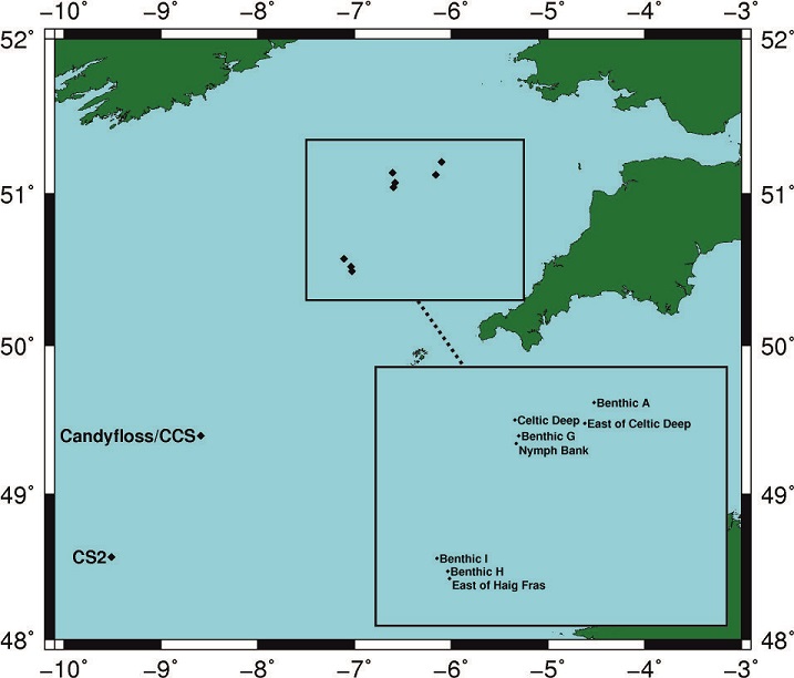
Shelf Seas Biogeochemistry Fixed Station Benthic A
This station is one of four benthic sites sampled on the Celtic Sea shelf as part of work package II of the Shelf Seas Biogeochemistry project. The station has a mean water depth 109 m at the following co-ordinates:
| Box Corner | Latitude | Longitude |
|---|---|---|
| North-west corner | 51.2173° | -6.1418° |
| South-east corner | 51.1988° | -6.0559° |
The position of this station relative to the other Shelf Seas Biogeochemistry sites can be seen from the figure below.
Sampling History
| DY008 | DY026A | DY018 | |
|---|---|---|---|
| CTD casts | 2 | 3 | 1 |
| Box cores | 61 | 4 | 5 |
| SPI camera | 5 | - | - |
| Stand Alone Pump Systems (SAPS) | 1 | - | - |
| Benthic flume | 1 | - | - |
| Multi-core | 2 | - | - |
| Glider deployments | 2 | 1 | - |
| Zooplankton net hauls | - | 10 | 5 |
| Marine snow catcher | - | 4 | - |
| Drifting buoy | - | 2 | - |
Related Fixed Station activities are detailed in Appendix 1
BODC Quality Control Flags
The following single character qualifying flags may be associated with one or more individual parameters with a data cycle:
| Flag | Description |
|---|---|
| Blank | Unqualified |
| < | Below detection limit |
| > | In excess of quoted value |
| A | Taxonomic flag for affinis (aff.) |
| B | Beginning of CTD Down/Up Cast |
| C | Taxonomic flag for confer (cf.) |
| D | Thermometric depth |
| E | End of CTD Down/Up Cast |
| G | Non-taxonomic biological characteristic uncertainty |
| H | Extrapolated value |
| I | Taxonomic flag for single species (sp.) |
| K | Improbable value - unknown quality control source |
| L | Improbable value - originator's quality control |
| M | Improbable value - BODC quality control |
| N | Null value |
| O | Improbable value - user quality control |
| P | Trace/calm |
| Q | Indeterminate |
| R | Replacement value |
| S | Estimated value |
| T | Interpolated value |
| U | Uncalibrated |
| W | Control value |
| X | Excessive difference |
SeaDataNet Quality Control Flags
The following single character qualifying flags may be associated with one or more individual parameters with a data cycle:
| Flag | Description |
|---|---|
| 0 | no quality control |
| 1 | good value |
| 2 | probably good value |
| 3 | probably bad value |
| 4 | bad value |
| 5 | changed value |
| 6 | value below detection |
| 7 | value in excess |
| 8 | interpolated value |
| 9 | missing value |
| A | value phenomenon uncertain |
| B | nominal value |
| Q | value below limit of quantification |
Appendix 1: Shelf Seas Biogeochemistry Fixed Station Benthic A
Related series for this Fixed Station are presented in the table below. Further information can be found by following the appropriate links.
If you are interested in these series, please be aware we offer a multiple file download service. Should your credentials be insufficient for automatic download, the service also offers a referral to our Enquiries Officer who may be able to negotiate access.
| Series Identifier | Data Category | Start date/time | Start position | Cruise |
|---|---|---|---|---|
| 1336667 | Water sample data | 2014-03-23 18:41:00 | 51.21351 N, 6.13705 W | RRS Discovery DY008 |
| 1371536 | CTD or STD cast | 2014-03-23 18:43:00 | 51.2135 N, 6.13703 W | RRS Discovery DY008 |
| 1371561 | CTD or STD cast | 2014-03-25 13:31:00 | 51.20968 N, 6.1388 W | RRS Discovery DY008 |
| 2117524 | Water sample data | 2014-03-25 13:35:30 | 51.20967 N, 6.1388 W | RRS Discovery DY008 |
| 2119082 | Water sample data | 2014-03-25 13:35:30 | 51.20967 N, 6.1388 W | RRS Discovery DY008 |
| 1336680 | Water sample data | 2014-03-25 13:36:00 | 51.20967 N, 6.1388 W | RRS Discovery DY008 |
| 1371597 | CTD or STD cast | 2014-03-31 19:00:00 | 51.21372 N, 6.13727 W | RRS Discovery DY008 |
| 1373266 | CTD or STD cast | 2014-08-11 10:58:00 | 51.21167 N, 6.14167 W | RRS Discovery DY026A |
| 2127739 | Water sample data | 2014-08-11 11:14:30 | 51.21178 N, 6.14148 W | RRS Discovery DY026A |
| 1373278 | CTD or STD cast | 2014-08-11 14:01:00 | 51.2055 N, 6.14183 W | RRS Discovery DY026A |
| 1373334 | CTD or STD cast | 2014-08-13 11:00:00 | 51.2095 N, 6.056 W | RRS Discovery DY026A |
| 2118202 | Water sample data | 2014-08-13 11:14:00 | 51.20958 N, 6.05587 W | RRS Discovery DY026A |
| 2127764 | Water sample data | 2014-08-13 11:14:00 | 51.20958 N, 6.05587 W | RRS Discovery DY026A |
| 1372607 | CTD or STD cast | 2014-11-28 20:02:00 | 51.21302 N, 6.13172 W | RRS Discovery DY018 (GApr04) |
| 2118005 | Water sample data | 2014-11-28 20:09:30 | 51.21302 N, 6.13174 W | RRS Discovery DY018 (GApr04) |
| 2120175 | Water sample data | 2014-11-28 20:09:30 | 51.21302 N, 6.13174 W | RRS Discovery DY018 (GApr04) |
| 2121615 | Water sample data | 2014-11-28 20:09:30 | 51.21302 N, 6.13174 W | RRS Discovery DY018 (GApr04) |
| 2127162 | Water sample data | 2014-11-28 20:09:30 | 51.21302 N, 6.13174 W | RRS Discovery DY018 (GApr04) |
| 1624159 | CTD or STD cast | 2015-03-03 07:00:00 | 51.21167 N, 6.13297 W | RRS Discovery DY021 |
| 2127198 | Water sample data | 2015-03-03 07:03:00 | 51.21167 N, 6.13297 W | RRS Discovery DY021 |
| 2135807 | Water sample data | 2015-03-03 07:03:00 | 51.21167 N, 6.13297 W | RRS Discovery DY021 |
| 1624160 | CTD or STD cast | 2015-03-03 12:29:00 | 51.21167 N, 6.13298 W | RRS Discovery DY021 |
| 2118030 | Water sample data | 2015-03-03 12:33:00 | 51.21165 N, 6.13296 W | RRS Discovery DY021 |
| 2127205 | Water sample data | 2015-03-03 12:33:00 | 51.21165 N, 6.13296 W | RRS Discovery DY021 |
| 2135819 | Water sample data | 2015-03-03 12:33:00 | 51.21165 N, 6.13296 W | RRS Discovery DY021 |
| 1624485 | CTD or STD cast | 2015-03-03 13:47:00 | 51.21167 N, 6.13298 W | RRS Discovery DY021 |
| 1624497 | CTD or STD cast | 2015-03-04 06:14:00 | 51.21163 N, 6.13368 W | RRS Discovery DY021 |
| 1624504 | CTD or STD cast | 2015-03-04 07:44:00 | 51.21162 N, 6.13372 W | RRS Discovery DY021 |
| 2119659 | Water sample data | 2015-03-04 07:51:00 | 51.21163 N, 6.13371 W | RRS Discovery DY021 |
| 2127383 | Water sample data | 2015-03-04 07:51:00 | 51.21163 N, 6.13371 W | RRS Discovery DY021 |
| 1624172 | CTD or STD cast | 2015-03-04 09:02:00 | 51.21162 N, 6.1337 W | RRS Discovery DY021 |
| 1624184 | CTD or STD cast | 2015-03-04 10:17:00 | 51.21163 N, 6.1337 W | RRS Discovery DY021 |
| 1624196 | CTD or STD cast | 2015-03-05 20:34:00 | 51.21148 N, 6.1305 W | RRS Discovery DY021 |
| 2127217 | Water sample data | 2015-03-05 20:43:00 | 51.2115 N, 6.1305 W | RRS Discovery DY021 |
| 2135820 | Water sample data | 2015-03-05 20:43:00 | 51.2115 N, 6.1305 W | RRS Discovery DY021 |
| 1626375 | CTD or STD cast | 2015-04-13 21:15:00 | 51.21378 N, 6.12875 W | RRS Discovery DY029 (GApr04) |
| 2118331 | Water sample data | 2015-04-13 21:27:00 | 51.21377 N, 6.12958 W | RRS Discovery DY029 (GApr04) |
| 2136835 | Water sample data | 2015-04-13 21:27:00 | 51.21377 N, 6.12958 W | RRS Discovery DY029 (GApr04) |
| 1627170 | CTD or STD cast | 2015-04-13 22:03:00 | 51.21383 N, 6.12967 W | RRS Discovery DY029 (GApr04) |
| 1626387 | CTD or STD cast | 2015-04-13 22:51:00 | 51.21348 N, 6.12972 W | RRS Discovery DY029 (GApr04) |
| 1626941 | CTD or STD cast | 2015-04-27 01:30:00 | 51.2131 N, 6.14655 W | RRS Discovery DY029 (GApr04) |
| 1627434 | CTD or STD cast | 2015-04-27 02:25:00 | 51.21312 N, 6.13 W | RRS Discovery DY029 (GApr04) |
| 2118527 | Water sample data | 2015-04-27 03:13:00 | 51.21312 N, 6.13001 W | RRS Discovery DY029 (GApr04) |
| 2136988 | Water sample data | 2015-04-27 03:13:00 | 51.21312 N, 6.13001 W | RRS Discovery DY029 (GApr04) |
| 1626953 | CTD or STD cast | 2015-04-27 03:25:00 | 51.2131 N, 6.13002 W | RRS Discovery DY029 (GApr04) |
| 1624725 | CTD or STD cast | 2015-05-10 05:09:00 | 51.20925 N, 6.13741 W | RRS Discovery DY030 |
| 2132404 | Water sample data | 2015-05-10 05:20:00 | 51.20925 N, 6.13741 W | RRS Discovery DY030 |
| 2137758 | Water sample data | 2015-05-10 05:20:00 | 51.20925 N, 6.13741 W | RRS Discovery DY030 |
| 1624737 | CTD or STD cast | 2015-05-10 06:41:00 | 51.20927 N, 6.13742 W | RRS Discovery DY030 |
| 1624590 | CTD or STD cast | 2015-05-10 07:49:00 | 51.20926 N, 6.13744 W | RRS Discovery DY030 |
| 1624608 | CTD or STD cast | 2015-05-10 09:16:00 | 51.20924 N, 6.13736 W | RRS Discovery DY030 |
| 2123382 | Water sample data | 2015-05-10 09:25:00 | 51.20924 N, 6.13736 W | RRS Discovery DY030 |
| 1624750 | CTD or STD cast | 2015-05-12 09:39:00 | 51.21034 N, 6.13264 W | RRS Discovery DY030 |
| 2132416 | Water sample data | 2015-05-12 09:50:00 | 51.21034 N, 6.13263 W | RRS Discovery DY030 |
| 2137771 | Water sample data | 2015-05-12 09:50:00 | 51.21034 N, 6.13263 W | RRS Discovery DY030 |
| 1624762 | CTD or STD cast | 2015-05-12 10:53:00 | 51.21033 N, 6.1326 W | RRS Discovery DY030 |
| 1624774 | CTD or STD cast | 2015-05-12 14:09:00 | 51.20937 N, 6.13063 W | RRS Discovery DY030 |
| 1625396 | CTD or STD cast | 2015-07-26 15:22:00 | 51.21303 N, 6.128 W | RRS Discovery DY033 (GApr04) |
| 2118748 | Water sample data | 2015-07-26 15:30:30 | 51.21305 N, 6.12802 W | RRS Discovery DY033 (GApr04) |
| 2123714 | Water sample data | 2015-07-26 15:30:30 | 51.21305 N, 6.12802 W | RRS Discovery DY033 (GApr04) |
| 2137992 | Water sample data | 2015-07-26 15:30:30 | 51.21305 N, 6.12802 W | RRS Discovery DY033 (GApr04) |
| 1625821 | CTD or STD cast | 2015-07-26 16:33:00 | 51.21305 N, 6.12805 W | RRS Discovery DY033 (GApr04) |
| 2120488 | Water sample data | 2015-07-26 16:38:30 | 51.21307 N, 6.12803 W | RRS Discovery DY033 (GApr04) |
| 2124059 | Water sample data | 2015-07-26 16:38:30 | 51.21307 N, 6.12803 W | RRS Discovery DY033 (GApr04) |
| 1721532 | CTD or STD cast | 2015-08-07 22:33:00 | 51.21065 N, 6.13043 W | RRS Discovery DY034 |
| 1721544 | CTD or STD cast | 2015-08-08 00:12:00 | 51.21093 N, 6.13088 W | RRS Discovery DY034 |
| 2119703 | Water sample data | 2015-08-08 00:29:00 | 51.21093 N, 6.13089 W | RRS Discovery DY034 |
| 1721267 | CTD or STD cast | 2015-08-08 01:25:00 | 51.21095 N, 6.1309 W | RRS Discovery DY034 |
| 2122250 | Water sample data | 2015-08-08 01:38:00 | 51.21094 N, 6.13089 W | RRS Discovery DY034 |
| 1721280 | CTD or STD cast | 2015-08-09 19:02:00 | 51.20935 N, 6.13003 W | RRS Discovery DY034 |
| 1721347 | CTD or STD cast | 2015-08-13 12:47:00 | 51.21258 N, 6.13277 W | RRS Discovery DY034 |
| 2122274 | Water sample data | 2015-08-13 13:02:00 | 51.21258 N, 6.13277 W | RRS Discovery DY034 |
| 1721360 | CTD or STD cast | 2015-08-15 16:09:00 | 51.21368 N, 6.13698 W | RRS Discovery DY034 |
| 1721488 | CTD or STD cast | 2015-08-29 16:27:00 | 51.23033 N, 6.13388 W | RRS Discovery DY034 |
