
![]()
Fieldwork |
![]()
| OMEX
I Shipboard Activities The shipboard activities during OMEX I may be classified into four types. The first were data collected by 'ships of opportunity'. These were merchant ships that towed the SAHFOS Continuous Plankton Recorder as they plied their normal routes between ports. The database on the CD-ROM includes data from samples collected from 295 such journeys that passed over the Goban Spur area between April 1964 and December 1995. The second classification were cruises primarily concerned with other projects, but offered assistance to OMEX activities. Included in this are cruises deploying and recovering OMEX moorings on the Meriadzek Terrace and cruises working sections over the shelf break that offered berths to OMEX scientists. Four cruises of this type are included in the database. OMEX I Research Cruises The third classification are what may be termed 'day trips' where a small vessel made measurements along a shelf break section close to her home port. Included here are seven short expeditions made by FV Madornia from Vigo, Spain in 1994 and 1995. Finally, there were research cruises primarily concerned with the OMEX project. A total of 46 cruise legs involving vessels from 8 nations provided data which are summarised in the chart below. |
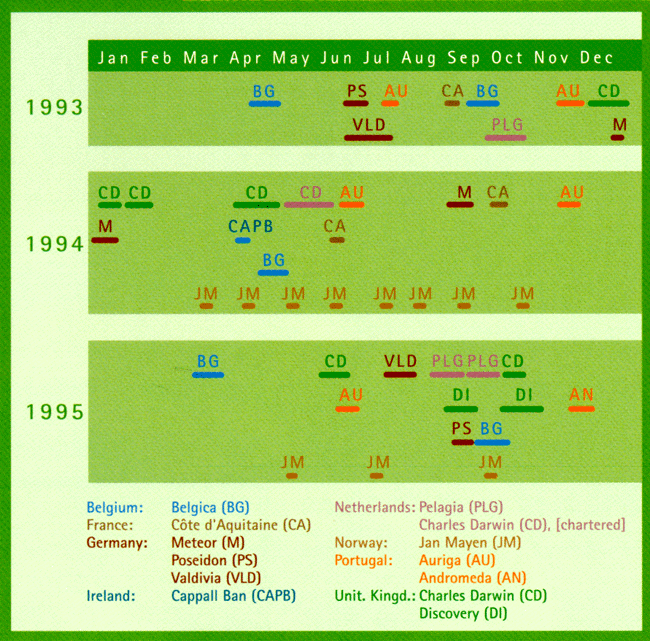
Cruises of the OMEX I Campaign (L.Chou)
| OMEX I Field Areas
|
|
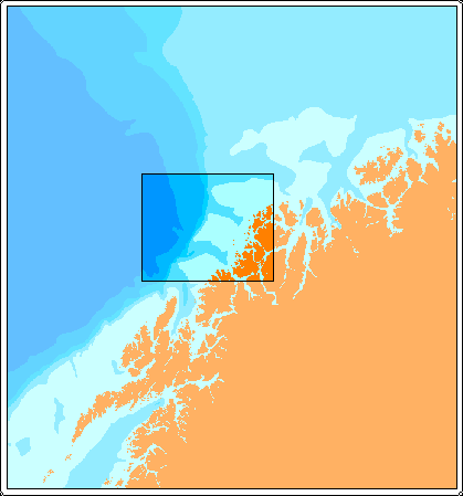 |
The fieldwork during OMEX I was primarily focused on three areas of the European continental margin. The first area studied was the slope off northern Norway from 69.5 to 70.6 N and 15 to 19.4 E. This region was visited by eleven cruises of the RV Jan Mayen collecting CTD, water bottle and drifting sediment trap data. |
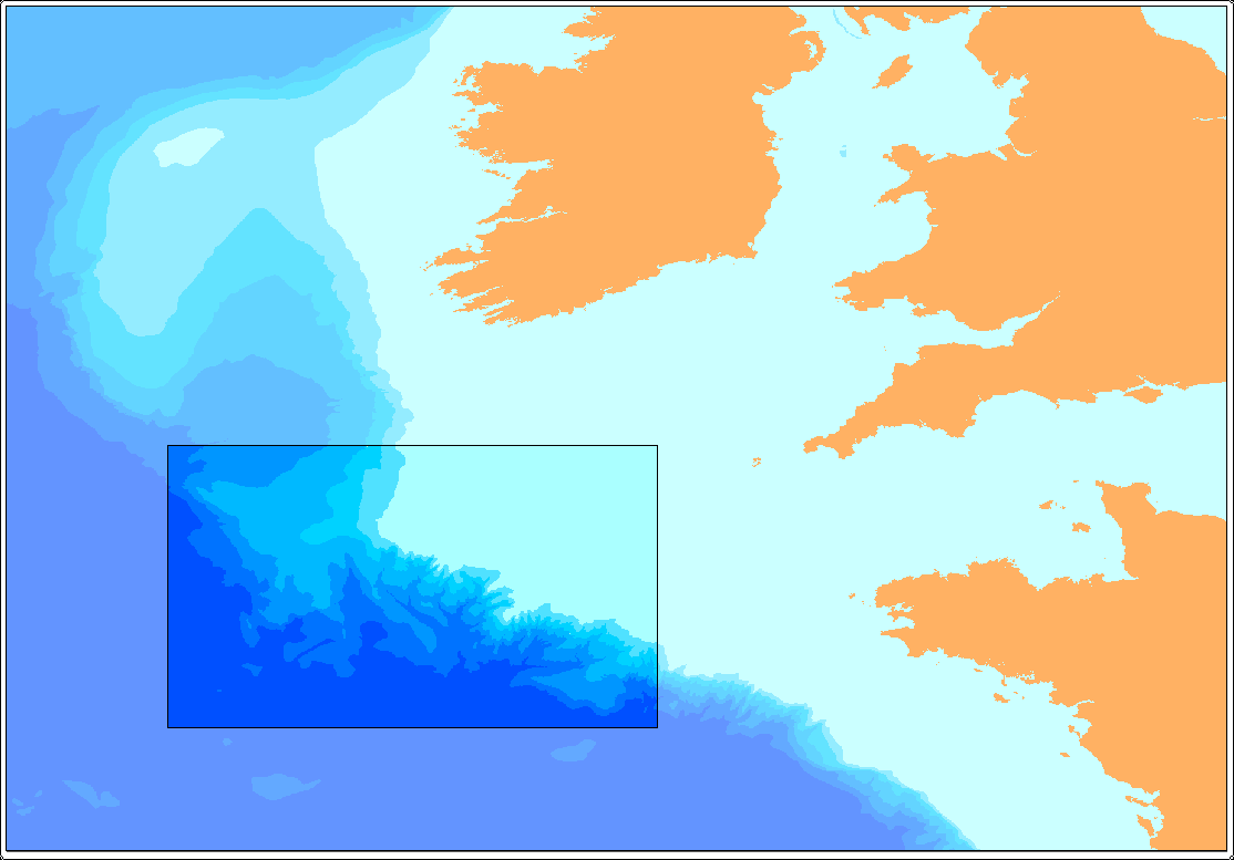
The main OMEX I field area was centred on the bathymetric feature known as the Goban Spur, south of the Porcupine Bight in the Celtic Sea. There were three primary stations that formed a section along the spur at which long-term sediment trap moorings were deployed. |
 |
|
|
|
| The
mean positions and water depths held in the database for these stations are: OMEX1 49.42 N 11.52 W 656 m water OMEX2 49.18 N 12.86 W 1620 m water OMEX3 49.08 N 13.42 W 3654 m water
|
|
In practice, only OMEX2 and OMEX3 returned sediment trap data because the OMEX1 mooring was trawled on its first deployment. The database includes events sampled in the vicinity of this section from 17 cruise legs showing this to be the most intensively sampled area during OMEX I.
|
|
The OMEX I 'Goban Spur' data set was not just confined to this section and data are included in the database along the shelf edge from La Chapelle Bank to the Hebridean Terrace. However, the data are noticeably concentrated to the south of 50 N.
|
|
The scope of the data collected in the vicinity of the Goban Spur was so large that it defies description. Over 800 parameters are held in the database that were measured on air, water, particulate matter and sediment samples from this region.
|
|
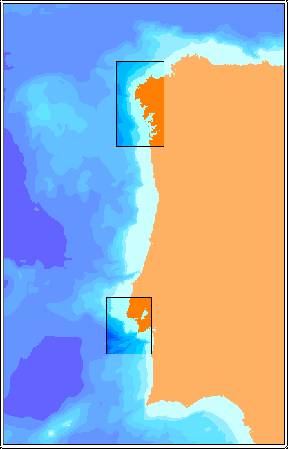 |
The third area studied during OMEX I was the Iberian Margin. A hydrographic (CTD, oxygen and nutrients) section off Vigo, Spain, was repeatedly surveyed during the FV Madornia campaign and the region from Vigo northwards was visited by one RV Belgica cruise collecting hydrographic and production data. Further to the south, in the vicinity of the River Tagus, the six PLUTUR cruises provided CTD surveys, data on particulate matter and sediment samples. Current meter moorings were also deployed off the Portuguese margin by RRS Charles Darwin.
|
The OMEX I data set can therefore be seen to extend over the entire length of the European continental margin and should include something of interest to anyone studying the oceanography of this important boundary. |
|
![]()
![]()
Updated : 10 September 2003, Feedback :
© NERC
