![]()
These pages have been prepared from BODC's OMEX II data tracking spreadsheet (see Explanatory Notes). This page contains a simple list of the cruises completed during the OMEX II project. For further information on each cruise and on the status of data sets collected during the cruise, select the relevant cruise identifier. For a copy of the cruise track chart (if available), select the relevant 'Tracks' text. Details of historical datasets obtained in the OMEX II study area are also summarised. |
![]()
SHIP |
IDENTIFIER |
DATES |
OBJECTIVES |
TRACKS |
Almeida de Carvalho |
12/11/1996 to 17/11/1996 |
Sedimentological survey (with multicorer, boxcorer and grab) on the Galician Margin and offshore northern Portuguese coast. |
Not Available |
|
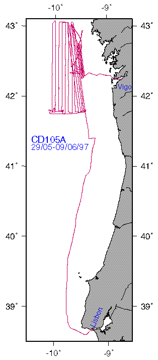
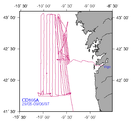
| Charles Darwin | 29/05/1997 to 09/06/1997 |
Swath bathymetry along Iberian slope from 41.5-43N out to 10W and beyond, especially 4240'N and 4220'N to cover intended mooring and coring positions; kasten and box coring on cross slope sections near 4148'N and 4220'N; trial deployment of POL echosounder mooring |
||
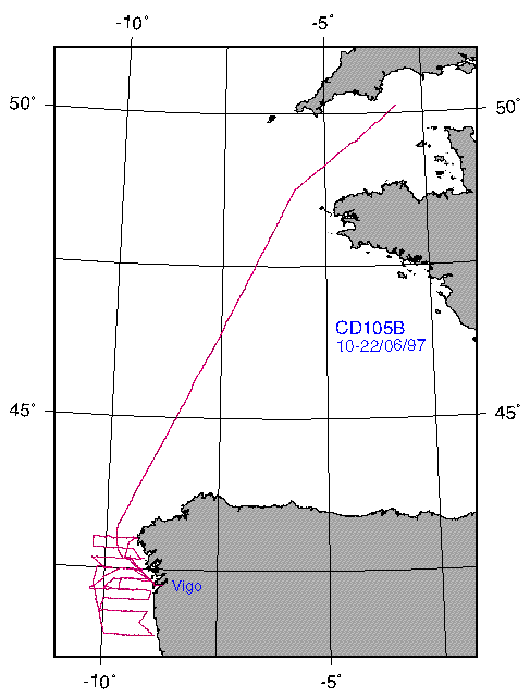
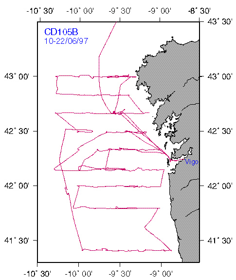
| Charles Darwin | 10/06/1997 to 22/06/1997 |
Mooring deployment (ADCP at 4240.94'N, 928.58'W; CCM at 4240.1'N, 934.4'W), biogeochemical survey with CTD cross-slope sections approx. 10km apart from 43N to 4125'N, underway measurements. Intercalibration station with Belgica |
||
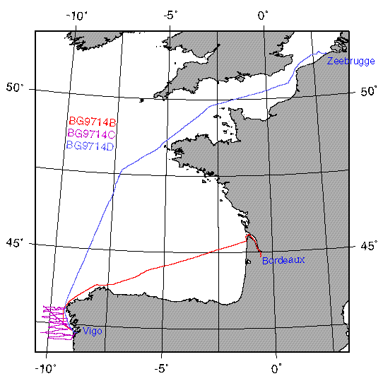
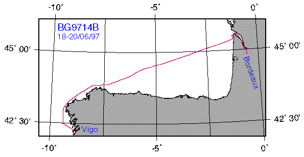
| Belgica | 18/06/1997 to 20/06/1997 |
Underway measurements and intercalibration station with RRS Charles Darwin |
||
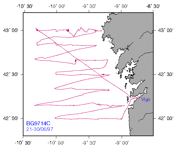
| Belgica | 21/06/1997 to 30/06/1997 |
Biogeochemical survey of the area 41-42N, 9-10.5W during the upwelling season. |
||
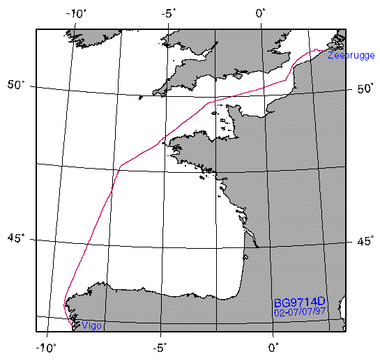
| Belgica | 02/07/1997 to 07/07/1997 |
Biogeochemical study of the area 47-48N, 7-7.5W in the vicinity of La Chapelle Bank. |
||
| Pelagia | 23/06/1997 to 14/07/1997 |
Pilot study of the sea-floor topography and its inhabitants off La Coruna and the Galicia Bank. Seismic surveying of three transects of which two were sampled for sediment for fauna, pigments, nucleic acids, C/N and porosity and on-board O2 incubations. Benthic trawls. |
Not available |
|
| Pelagia | 15/07/1997 to 06/08/1997 |
Acoustic survey along 5 transects perpendicular to the Iberian Margin bathymetry; subsequent sampling of water column, the sediment-water interface and the bottom sediments along transects at 4240'N and 4220'N; deployment of BOBO |
||
Almeida de Carvalho |
06/12/1997 to 15/12/1997 |
Hydological study of the transfer of particulate matter from the continent to the oceans using CTD profiling, surface SPM filtration and water bottle profiling along the Iberian Peninsula (41N to 4151'N; coast to 10W) |
Not yet available |
|
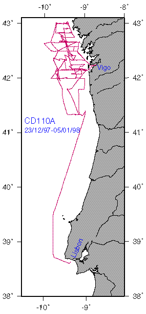
| Charles Darwin | 23/12/1997 to 05/01/1998 |
Study of the cycles of carbon, nutrients and other trace elements, their deposition and lateral and vertical transport focussing on the NW Iberian Shelf and slope. The systematic mapping of water properties over the area 41.5 to 43N, mooring recovery and deployment, and core and grab sampling of the sea bed to derive sediment records and distributions. |
||
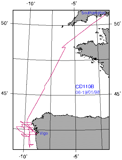
| Charles Darwin | 06/01/1998 to 19/01/1998 |
Measurement of the mesoscale spatial variability of water transport, particles, carbon and nutrients in the shelf and slope waters of the Iberian Margin (4125'-4300'N, 0857'-1018'W). |
||
| Poseidon | 26/02/1998 to 16/03/1998 |
Determination of cross- and along-slope gradients in physical and biological water column properties to the Northerm Iberian Peninsula. Recovery and deployment of OMEX-II sediment trap and current meter moorings. SAPS added. |
Not Available |
|
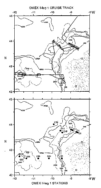
| Pelagia | PE64/118 | 25/05/1998 to 12/06/1998 | Study of the distribution and activity of organisms living on the sea floor off NW Spain and concurrently of the sediment concentrations of organic carbon and biomarkers. | Full Cruise |
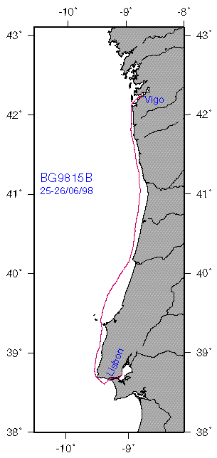
| Belgica | BG9815B | 25/06/1998 to 26/06/1998 | Underway measurements between Lisbon and Vigo. | Full Cruise |
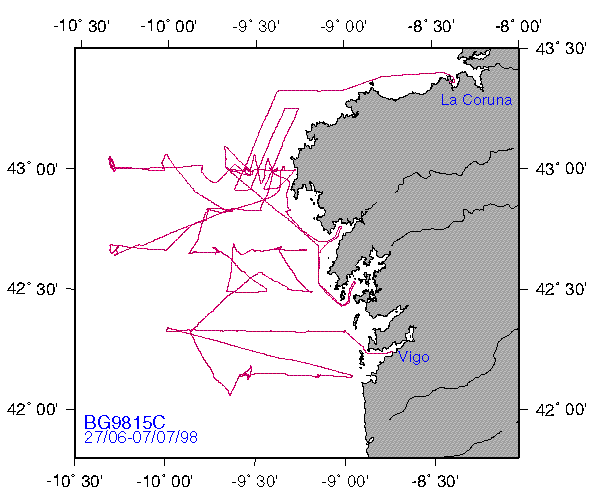
| Belgica | BG9815C | 27/06/1998 to 07/07/1998 | Biogeochemical study of the area 42-43 30'N, 9-9 30'W in the vicinity of La Chapelle Bank. | Full Cruise |
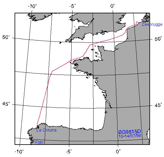
| Belgica | BG9815D | 10/07/1998 to 15/07/1998 | Biogeochemical study of the area 47-48N, 7-7.5W in the vicinity of La Chapelle Bank. Underway measurements along English Channel to Zeebrugge. | Full Cruise |
| Cotes de la Manche | GAMINEX | 08/07/1998 to 19/07/1998 | Sedimentological survey (with multicorer, boxcorer and grab) on the Galician Margin and offshore northern Portuguese coast. | Not yet available. |
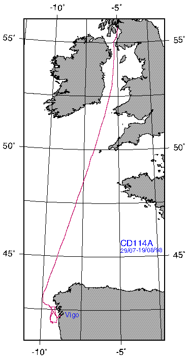
| Charles Darwin | CD114A | 29/07/1998 to 11/08/1998 | Study of biological activity and response to upwelling of nutrient-rich waters from the deep ocean onto the shelf. Emphasis on phytoplankton processes. | Full Cruise |
| Pelagia | PE64/121 | 30/07/1998 to 16/08/1998 | Benthic processes cruise. | Not available |
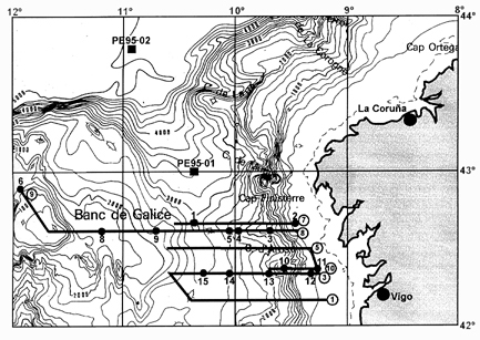
| R/V Professor Shtokman | ST0898 | 01/08/1998 to 11/08/1998 | WP2 slope survey to study the physical, chemical and biological properties in the continental shelf and shelf break zone of the Galician coast near the Rias Baixas during summer. The study area is located between Cape Finisterre (43 00'N) and Ra de Vigo (42 09'N). | Transects |
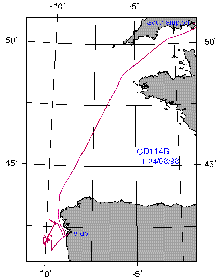
| Charles Darwin | CD114B | 11/08/1998 to 24/08/1998 | Filament experiment with emphasis on mesozooplankton grazing. | Full Cruise |
| Pelagia | PE64/123 | 02/09/1998 to 18/09/1998 | Benthic Survey to study the distribution and activity of sea floor communities off NW Spain and concurrently of the sediment concentration of organic matter and biomarkers. | Not available |
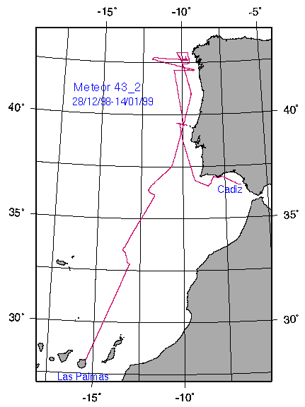
| Meteor | M43-2 | 28/12/1998 to 14/01/1999 | Winter study of the cycles of carbon, nutrients and other trace elements, their deposition and lateral and vertical transport focussing on the OMEX box off Vigo and the Nazar Canyon, including the recovery of the main OMEX trap moorings. A short bathymetric/seismic profiling section was worked off Faro to provide supporting data for the INDIA project. | Full Cruise |
| Almeida Carvalho | OMEX99 | 03/05/1999 to 30/05/1999 | WP2 slope survey to study the physical, chemical and biological properties in the continental shelf and shelf break zone of the Galician coast near the Rias Baixas during summer. | Not yet available |
| Pelagia | PE64/138 | 08/05/1999 to 01/06/1999 | Benthic Survey to study the distribution and activity of sea floor communities off NW Spain and concurrently of the sediment concentration of organic matter and biomarkers. | Not Yet available. |
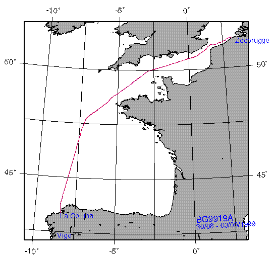
| Belgica | BG9919A | 30/08/1999 to 03/09/1999 | Underway measurements between Zeebrugge and La Corua with biological survey of area at La Chapelle Bank (~47 30'N, 7 10'W). | Full Cruise |
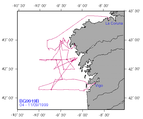
| Belgica | BG9919B | 04/09/1999 to 11/09/1999 | Intensive biogeochemical study of an area (42-43 N, 9-10 20'W) off the Iberian Peninsula. | Full Cruise |
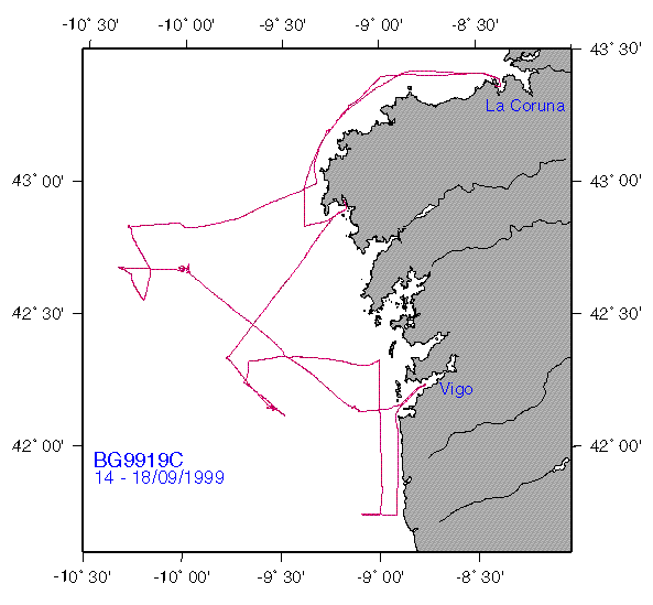
| Belgica | BG9919C | 14/09/1999 to 18/09/1999 | Intensive biogeochemical survey of the Iberian Peninsula (42-43 N, 9-10 20'W). | Full Cruise |
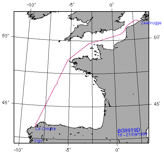
| Belgica | BG9919D | 18/09/1999 to 21/09/1999 | Underway measurements between La Corua and Zeebrugge. | Full Cruise |
| Thalassa | TH1099 | 13/10/1999 to 20/10/1999 | WP2 continenetal shelf and shelf-break survey | Not Yet available. |
SURVEY |
DATES |
DESCRIPTION |
DATA HELD |
CPR Data |
1997 |
Continuous Plankton Recorder Data (Temperature/Salinity/Chlorophyll/Plankton) from 1997 |
BODC |
CPR Data |
1-6/1998 |
Continuous Plankton Recorder Data (Temperature/Salinity/Chlorophyll/Plankton) from first half of 1998 |
BODC |
Met. Data |
01/06/1997 to 31/12/1998 |
Meteorological data for the Galician region from the Spanish Met. Office (restricted) |
BODC |
GALICIA II |
14/08/1975 to 09/09/1975 |
Galician coastal survey (4209'-4414'N, 700'-957'W) - salinity and dissolved oxygen profiles |
IIM |
GALICIA III |
03/06/1976 to 25/06/1976 |
Galician coastal survey (4210'-4416'N, 705'-936'W) - salinity and dissolved oxygen profiles |
IIM |
GALICIA IV |
07/10/1977 to 28/10/1977 |
Galician coastal survey (4200'-4420'N, 730'-1020'W) - salinity, dissolved oxygen, nutrient profiles |
IIM |
GALICIA VII |
18/02/1984 to 07/03/1984 |
Galician coastal survey (4000'-4700'N, 0752'-1123'W) - salinity, dissolved oxygen, nutrient profiles |
BODC |
GALICIA VIII |
13/07/1984 to 24/07/1984 |
Galician coastal survey (4154'-4415'N, 0701'-0941'W) - salinity, dissolved oxygen, nutrient profiles |
BODC |
GALICIA IX |
04/09/1986 to 27/09/1986 |
Galician coastal survey (4051'-4444'N, 1044'-1416'W) - salinity, dissolved oxygen, nutrient profiles |
BODC |
GALICIA X |
22/05/1989 to 30/10/1989 |
Galician coastal survey (4218'N, 0857'W) - salinity, dissolved oxygen, nutrient profiles |
IIM |
GALICIA XI |
10/05/1991 to 14/05/1991 |
Galician coastal survey (4200'-4400'N, 0700'-1100'W) - salinity, dissolved oxygen, nutrient profiles |
BODC |
GALICIA XII |
10/09/1991 to 18/09/1991 |
Galician coastal survey (4401'-4152'N, 0704'-0955'W) - salinity, dissolved oxygen, nutrient profiles |
BODC |
MORENA I |
10/05/1993 to 26/05/1993 |
Ria of Vigo to shelf, three-station radial transect survey (4000'-4300'N, 1040'-0949'W) - salinity, dissolved oxygen, pH, alkalinity, nutrient profiles |
BODC |
MORENA II |
16/11/1993 to 02/12/1993 |
Ria of Vigo to shelf, three-station radial transect survey (4000'-4142'N, 0940'-1100'W) - salinity, dissolved oxygen, pH, alkalinity, nutrient profiles |
IIM |
MORENA III |
26/07/1994 to 08/08/1994 |
Ria of Vigo to shelf, three-station radial transect survey (4048'-4230'N, 0900'-1100'W) - salinity, dissolved oxygen, pH, alkalinity, nutrient profiles |
IIM |
![]()
![]() Back to the OMEX home page
Back to the OMEX home page
![]() Back to the OMEX
II-II Index
Back to the OMEX
II-II Index
![]()
Updated : 11 September 2003, Feedback :
© NERC

In order to keep track of all the diverse data being collected in OMEX II, BODC maintains a data tracking spreadsheet with entries for each cruise as follows: ship name and country (of principal scientist), cruise identifier, name of principal scientist, start and end dates for the cruise, and a flag to indicate whether a cruise report has been received by BODC. Each data set collected on the cruise is accorded a single line entry comprising a count of the number of units of data in the data set (where known), a short data set descriptor and a flag (awaiting data/data received) to indicate whether the data set has been submitted to BODC. Source material for BODC's data tracking spreadsheet is normally compiled from cruise reports or, when these are not available, from Cruise Summary Reports or other material submitted to BODC. However, in some cases, the information is not made available to BODC until the data have actually been submitted! Therefore, despite BODC's best endeavours, the data tracking information should not be regarded as being comprehensive. Where available, small-scale cruise track plots contained in the cruise reports or other documents are optically scanned when received at BODC and their images are made available through WWW. WWW pages have been prepared from the data tracking spreadsheets and comprise a full list of the OMEX II cruises, together with the information currently available to BODC on the data sets collected on each cruise and, where available, a copy of the cruise track chart image. These pages are updated as and when new information is received by BODC.
|