GEOTRACES Intermediate Data Product 2017 (Version 2)
The GEOTRACES Intermediate Data Product (IDP2017v2) was made available on 14 February 2018. The IDP2017 data product gathers the data acquired during the first 6 years of the programme and builds on the product released in 2014. It expands on the collection of results from the Atlantic and Arctic Oceans and adds new data from the Pacific and Southern Oceans. Version 2 includes additional data not available for version 1 and other amendments as detailed in the IDP2017v2 changes document ![]() .
.
The GEOTRACES IDP2017v2 consists of two parts:
- the digital datasets — available for download below or as a subset via the online service hosted by the Alfred Wegener Institute (AWI). The digital datasets contain hydrographic and biogeochemical data for about 2000 stations from more than 40 cruises and cover the global ocean, with data density being the highest in the Atlantic.
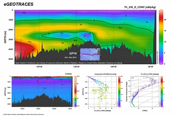
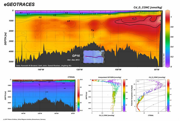
- the eGEOTRACES Electronic Atlas — is based on the digital data package and provides section plots (as illustrated below) and animated 3D scenes for many of the parameters. The 3D scenes provide geographical context, which is crucial for correctly assessing extent and origin of tracer plumes as well as for inferring processes acting on the tracers and shaping their distribution.
© 2017 Reiner Schlitzer, Alfred Wegener Institute (AWI), Bremerhaven, Germany.
© 2017 Reiner Schlitzer, Alfred Wegener Institute (AWI), Bremerhaven, Germany.
 along a GEOTRACES section between Peru and Tahiti.")
© 2017 Reiner Schlitzer, Alfred Wegener Institute (AWI), Bremerhaven, Germany.
IDP2017 version 2 digital datasets
The IDP2017 digital datasets are made available to download by the GEOTRACES International Data Assembly Centre hosted by the British Oceanographic Data Centre (BODC). They are provided in 4 data formats: ASCII, Microsoft Excel, NetCDF and ODV collections. The latter is for use with the Ocean Data View software.
To access these datasets you will be required to register as a BODC web user and agree to the terms and conditions of the GEOTRACES IDP2017 download agreement. This includes a requirement that you commit to proper citations of the product itself and of the relevant original papers associated with the particular data used.
The citation to use for IDP2017 is that given in the download agreement, that is:
Schlitzer, R., Anderson, R. F., Masferrer Dodas, E, et al., The GEOTRACES Intermediate Data Product 2017, Chem. Geol. (2018), https://doi.org/10.1016/j.chemgeo.2018.05.040.
CTD Sensor Data
- CTD Sensor Data — ODV format (113.2 MB) IDP2017 digital dataset
- CTD Sensor Data — ASCII format (38.4 MB) IDP2017 digital dataset
- CTD Sensor Data — NetCDF format (24.5 MB) IDP2017 digital dataset
Discrete Sample Data
- Discrete Sample Data — ODV format (138.5 MB) IDP2017 digital dataset
- Discrete Sample Data — ASCII format (9.0 MB) IDP2017 digital dataset
- Discrete Sample Data — Excel format (71.6 MB) IDP2017 digital dataset
- Discrete Sample Data — NetCDF format (10.7 MB) IDP2017 digital dataset
Please see IDP2017 version 2 known issues ![]() for further information on bad data points which have recently been acknowledged.
for further information on bad data points which have recently been acknowledged.
Aerosol and Rain Data
- Aerosol and Rain Data — ODV format (33.9 MB) IDP2017 digital dataset
- Aerosol and Rain Data — ASCII format (2.0 MB) IDP2017 digital dataset
- Aerosol and Rain Data — Excel format (2.2 MB) IDP2017 digital dataset
- Aerosol and Rain Data — NetCDF format (2.0 MB) IDP2017 digital dataset
More information is provided on the IDP2017 brochure.
Please help us to improve the Intermediate Data Product by sending us your feedback.
Links to previous GEOTRACES IDP versions and historical TEI data
