Metadata Report for BODC Series Reference Number 2027032
Metadata Summary
Problem Reports
Data Access Policy
Narrative Documents
Project Information
Data Activity or Cruise Information
Fixed Station Information
BODC Quality Flags
SeaDataNet Quality Flags
Metadata Summary
Data Description |
|||||||||||||||||||||||||||||
|
|||||||||||||||||||||||||||||
Data Identifiers |
|||||||||||||||||||||||||||||
|
|||||||||||||||||||||||||||||
Time Co-ordinates(UT) |
|||||||||||||||||||||||||||||
|
|||||||||||||||||||||||||||||
Spatial Co-ordinates | |||||||||||||||||||||||||||||
|
|||||||||||||||||||||||||||||
Parameters |
|||||||||||||||||||||||||||||
|
|||||||||||||||||||||||||||||
|
|||||||||||||||||||||||||||||
Problem Reports
No Problem Report Found in the Database
Data Access Policy
Open Data
These data have no specific confidentiality restrictions for users. However, users must acknowledge data sources as it is not ethical to publish data without proper attribution. Any publication or other output resulting from usage of the data should include an acknowledgment.
If the Information Provider does not provide a specific attribution statement, or if you are using Information from several Information Providers and multiple attributions are not practical in your product or application, you may consider using the following:
"Contains public sector information licensed under the Open Government Licence v1.0."
Narrative Documents
Kongsberg EM 710 multibeam echosounder
The Kongsberg EM710 is a high resolution multibeam echosounder. It operates at frequencies from 70 to 100 kHz, with a maximum ping rate of 30 Hz. The EM710 features a depth range of 3m below the transducer to 2000m (1000m for the EM710S model, and 600m for the EM710RD model). The swath width is up to 5.5 times water depth, to a maximum of more than 2000m.
For more information, please see this document: https://www.bodc.ac.uk/data/documents/nodb/pdf/em710_product_specification.pdf
JC125 CODEMAP Bathymetry: Originator's Data Processing
Sampling Strategy
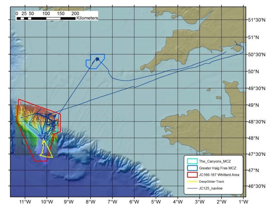
Kongsberg EM120 and EM710 multibeam bathymetry data were collected on board RRS James Cook cruise JC125 from 9th August to 12th September 2015. This cruise set out to re-map the Whittard Canyon and build upon previous surveys completed during JC035 from 20th June to 28th July 2009, to obtain a better insight in the biodiversity patterns, benthic habitat distributions and sediment transport processes of submarine canyons.
The data collection was funded under the COmplex Deep-sea Ecosystems: Mapping habitat heterogeneity As Proxy for biodiversity (CODEMAP) project, under European grant reference 258482. Further information is available in the cruise report.
Data Processing
Shipboard multibeam data were collected using a 191-beam Kongsberg EM120 system along all long transits and a few dedicated multibeam surveys. A 200-beam Kongsberg EM710 was also used for a dedicated survey at the sandwave area of Whittard Canyon. For dedicated surveys, a speed of 8 knots was used, occasionally reduced to 6 knots when data quality was too poor. All other transits were carried out at full speed (~10 knots).
The system was kept in 'AUTO' mode with varying expected depths to account for the quickly varying terrain, and the swath width was fixed at 60 degrees on either side, with equidistant spacing. A sound velocity profile (SVP) was taken at Haig Fras as well as in the deeper channel of Whittard Canyon and employed for the remainder of the surveys. A 10m offset had to be applied to the Haig Fras SVP. Additional sound velocity profiles were recorded during certain CTD stations.
Data processing was carried out in Caris HIPS and SIPS v8.0. For each area, a new project was created using UTM zone 29. Two vessel files were created, one for each instrument, with the following offsets:
EM120:
- Time Corr: 0.00
- X (m): 0.013
- Y (m): 4.988
- Z (m): 6.965
- Pitch (degrees): 0.00
- Roll (degrees): 0.00
- Yaw (degrees): 0.00
EM710:
- Time Corr: 0.00
- X (m): 1.832
- Y (m): 19.199
- Z (m): 6.944
- Pitch (deg): 0.00
- Roll (deg): 0.00
- Yaw (deg): 0.00
The data were imported as .all, and were checked for navigation and attitude (generally deemed ok by the science party). The software Polpred (National Oceanography Centre) was used to predict the tides for Whittard Canyon. The data were merged and data cleaning was carried out on the individual lines using the Subset Editor. A BASE surface with 10m (EM710) and 50m (EM120) grid sizes were calculated.
The dedicated-survey grids were exported into Geographic decimal degrees as ASCII .txt files with latitude, longitude and depth, and submitted to BODC.
JC125 CODEMAP Bathymetry: Processing by BODC
The multibeam bathymetry data from JC125 at Whittard Canyon were supplied to BODC as 2 ASCII files: one from the EM120 and one from the EM710. Datasets were are transferred into a common format, a netCDF subset. The following table shows how the variables within the files were mapped to the appropriate BODC parameter codes:
| Original parameter name | Original Units | BODC Parameter Code | BODC Units | Comments |
|---|---|---|---|---|
| Latitude | Degrees | ALATGP01 | Degrees | - |
| Longitude | Degrees | ALONGP01 | Degrees | - |
| Seafloor height | Metres | MBTHHGHT | Metres | - |
Following transfer, the data are screened visually, using BODC's in-house visualisation software, and any spikes or instrument malfunctions are clearly labelled with quality control flags.
Project Information
COmplex Deep-sea Environments: Mapping habitat heterogeneity As Proxy for biodiversity (CODEMAP)
Background
The deep ocean is considered the last frontier on Earth, holding resources such as food, minerals and hydrocarbons that increasingly attract human attention as potential alternatives for dwindling stocks on land. However, the deep sea is poorly understood: many areas are yet to be explored, and new species are still found on a regular basis. This lack of understanding hampers our ability to assess the potential impact of human activities in these waters, and limits our capability to design effective management strategies for future activities.
Biodiversity, the main indicator of ecosystem status and functioning, is the key parameter underpinning most ecosystem-based approaches to marine spatial planning and conservation, but measuring it is a major challenge in deep water; traditional sampling schemes are expensive and time-consuming, and their limited coverage makes it difficult to relate the results to regional patterns. Complex deep-sea environments are especially problematic due to their steep and irregular terrain. Ecosystem hotspots such as canyons or coral reefs contain true 3D morphology that cannot be surveyed with conventional techniques. CODEMAP aims to quantify habitat heterogeneity in complex deep-sea terrains, and evaluate its potential as a proxy for benthic biodiversity at a variety of scales. Habitat heterogeneity has been suggested as a major driver for deep-sea biodiversity, but is rarely quantified in a spatial context in the marine realm.
To achieve its goal, CODEMAP will combine the fields of marine geology, ecology, remote sensing and underwater vehicle technology to establish an integrated, statistically robust, and fully 3D methodology to map complex deep-sea habitats. Statistical techniques will be developed to extrapolate quantitative habitat information from fine-scale surveys to broad-scale maps. The optimal parameters to measure habitat heterogeneity will be defined, and their potential as biodiversity indicators tested through correlation with traditional approaches. The project focuses on submarine canyons, but the techniques will also be transferred to other environments. CODEMAP is expected to have a strong impact on the fundamental understanding of the deep sea and on ecosystem-based deep-sea management.
The research is organised around four themes:
- Top-down analysis: robust mapping of habitats and marine landscapes on the regional to medium scale.
- Quantification of habitat heterogeneity and evaluation of its potential as proxy for biodiversity.
- Bottom-up analysis: finding quantitative relationships that can bring information from a more detailed to a broader scale.
- Habitat heterogeneity in 3D through mapping and visualisation.
Fieldwork
Fieldwork was carried out on two research cruises. JC060 (RRS James Cook) between May and June 2011. The cruise covered the areas of Rockall Trough, Rockall Bank and Hatton Basin, northwest of Scotland and Ireland, and used an Autosub6000 Autonomous Underwater Vehicle (AUV), newly equipped with an EdgeTech dual frequency high-resolution sidescan sonar plus chirp profiler and a monochrome stills camera, a commercial inspection class ROV, and more traditional equipment including piston-, mega- and boxcores, CTD and shipborne multibeam (EM120 and EM710). The second cruise was from August to September 2015 on board JC125 (RRS James Cook) which covered the Whittard Canyon, south-west of Ireland and the UK. This cruise involved the ROV Isis and AUV Autosub6000, CTDs, ADCPs, piston-, mega- and boxcores, and shipborne multibeam (EM120 and EM710).
Participants
- Dr Veerle Huvenne (Principal investigator) National Oceanography Centre, Southampton.
- Dr Daniel Jones (Co-Investigator) National Oceanography Centre, Southampton.
- Dr Tim Le Bas (Co-Investigator) National Oceanography Centre, Southampton.
- Steve McPhail (Co-Investigator) National Oceanography Centre, Southampton.
- Katleen Robert (Co-Investigator) National Oceanography Centre, Southampton.
- Khaira Ismail (Co-Investigator) National Oceanography Centre, Southampton.
- Dr Claudio Lo Iacono (Co-Investigator) National Oceanography Centre, Southampton.
Funding
The project was funded under the EU Commission Seventh Framework Programme, FP7 (2007-2013), grant agreement ID 258482. It ran from 1st April 2011 to 31st January 2017. More information can be found here and on the website.
Data Activity or Cruise Information
Cruise
| Cruise Name | JC125 (JC124, JC126) |
| Departure Date | 2015-08-09 |
| Arrival Date | 2015-09-12 |
| Principal Scientist(s) | Jennifer A Gales (University of Plymouth, School of Biological and Marine Sciences), Russell B Wynn (National Oceanography Centre, Southampton), Veerle A Huvenne (National Oceanography Centre, Southampton) |
| Ship | RRS James Cook |
Complete Cruise Metadata Report is available here
Fixed Station Information
Fixed Station Information
| Station Name | Whittard Canyon - The Canyons Marine Conservation Zone |
| Category | Offshore area |
| Latitude | 48° 6.00' N |
| Longitude | 10° 18.00' W |
| Water depth below MSL | 3600.0 m |
Fixed Station - Whittard Canyon - The Canyons Marine Conservation Zone
The Canyons MCZ is located in the far south-west corner of the UK continental shelf, more than 330 km from Land's End, Cornwall. It encompasses the steep part of the shelf break where the seabed drops from a depth of 100 m to the oceanic abyssal plain at 2000 m. It is unique within the context of England's largely shallow seas due to its depth, sea-bed topography and the coral features it contains.
There are two large canyons within the site, which add to its topographic complexity: the Explorer Canyon to the north and the Dangaard Canyon below it. The wider Whittard Canyon area encapsulates the Canyons MCZ and also includes a network of submarine canyons to the West. The MCZ, also known as a Marine Protected Area (MPA), was designated in November 2013 under the Marine and Coastal Access Act (2009). The Canyons MCZ covers an area of 661 km2, which extends to approximately 5200 km2 when Whittard Canyon is included.
On the northernmost wall of the Explorer Canyon is a patch of live Cold-water coral reef (Lophelia pertusa) and Coral gardens, both of which are a OSPAR threatened and/or declining habitat. This is the only known example of living Cold-water coral reef recorded within England's seas, making it unique in these waters.
Cold-water corals and Coral gardens typically support a range of other organisms. The coral provides a three-dimensional structure and a variety of microhabitats that provide shelter and an attachment surface for other species. Both Cold-water corals and Coral gardens can be long-lived but are extremely slow growing (at about 6 mm a year), making protection important for their conservation. Another reef-forming cold-water coral, Madrepora oculata, is also present in the site.
The variety of deep-sea bed communities present are indicative of the range of substrates found in and around the canyons, including bedrock, biogenic reef, coral rubble, coarse sediment, mud and sand. These biological communities include cold-water coral communities (Lophelia pertusa and Madrepora oculata), Coral gardens, feather star (Leptometra celtica) assemblages and Sea-pen and burrowing megafauna communities (including, burrowing anemone fields, squat lobster (Munida sp.) assemblages, barnacle assemblages and deep-sea sea-pen (Kophobelemnon sp.) fields).
Sampling History
| JC035 (2009) | JC125 (2015) | JC166/7 (2018) | |
|---|---|---|---|
| ROV video/photography | Y | Y | Y |
| AUV video/photography | N | Y | Y |
| Shipboard Multibeam Bathymetry | Y | Y | Y |
| AUV Multibeam Bathymetry | N | Y | Y |
| AUV Sidescan Sonar | N | Y | Y |
| TOBI Sidescan Sonar | Y | Y | Y |
| ROV vibrocorer | N | Y | N |
| CTD casts | N | Y | N |
| SAPS | N | Y | N |
Related Fixed Station activities are detailed in Appendix 1
BODC Quality Control Flags
The following single character qualifying flags may be associated with one or more individual parameters with a data cycle:
| Flag | Description |
|---|---|
| Blank | Unqualified |
| < | Below detection limit |
| > | In excess of quoted value |
| A | Taxonomic flag for affinis (aff.) |
| B | Beginning of CTD Down/Up Cast |
| C | Taxonomic flag for confer (cf.) |
| D | Thermometric depth |
| E | End of CTD Down/Up Cast |
| G | Non-taxonomic biological characteristic uncertainty |
| H | Extrapolated value |
| I | Taxonomic flag for single species (sp.) |
| K | Improbable value - unknown quality control source |
| L | Improbable value - originator's quality control |
| M | Improbable value - BODC quality control |
| N | Null value |
| O | Improbable value - user quality control |
| P | Trace/calm |
| Q | Indeterminate |
| R | Replacement value |
| S | Estimated value |
| T | Interpolated value |
| U | Uncalibrated |
| W | Control value |
| X | Excessive difference |
SeaDataNet Quality Control Flags
The following single character qualifying flags may be associated with one or more individual parameters with a data cycle:
| Flag | Description |
|---|---|
| 0 | no quality control |
| 1 | good value |
| 2 | probably good value |
| 3 | probably bad value |
| 4 | bad value |
| 5 | changed value |
| 6 | value below detection |
| 7 | value in excess |
| 8 | interpolated value |
| 9 | missing value |
| A | value phenomenon uncertain |
| B | nominal value |
| Q | value below limit of quantification |
Appendix 1: Whittard Canyon - The Canyons Marine Conservation Zone
Related series for this Fixed Station are presented in the table below. Further information can be found by following the appropriate links.
If you are interested in these series, please be aware we offer a multiple file download service. Should your credentials be insufficient for automatic download, the service also offers a referral to our Enquiries Officer who may be able to negotiate access.
| Series Identifier | Data Category | Start date/time | Start position | Cruise |
|---|---|---|---|---|
| 2026920 | Bathymetry | 2009-06-09 00:00:00 | 47.1792 N, 11.2483 W | RRS James Cook JC035 |
| 2026932 | Bathymetry | 2009-06-09 00:00:00 | 48.4273 N, 11.2343 W | RRS James Cook JC035 |
| 2202723 | CTD or STD cast | 2009-06-22 14:25:05 | 48.15317 N, 10.53967 W | RRS James Cook JC036 |
| 2202735 | CTD or STD cast | 2009-07-09 18:58:19 | 48.81283 N, 11.15917 W | RRS James Cook JC036 |
| 2202747 | CTD or STD cast | 2009-07-10 23:22:15 | 48.2835 N, 10.314 W | RRS James Cook JC036 |
| 2202759 | CTD or STD cast | 2009-07-12 00:52:48 | 48.26533 N, 10.182 W | RRS James Cook JC036 |
| 2202760 | CTD or STD cast | 2009-07-18 05:48:17 | 48.60333 N, 9.9665 W | RRS James Cook JC036 |
| 2202772 | CTD or STD cast | 2009-07-26 03:59:18 | 48.653 N, 10.033 W | RRS James Cook JC036 |
| 2202803 | CTD or STD cast | 2015-08-13 21:32:12 | 47.9595 N, 10.217 W | RRS James Cook JC125 (JC124, JC126) |
| 2027020 | Bathymetry | 2015-08-14 01:23:00 | 47.5404 N, 11.2236 W | RRS James Cook JC125 (JC124, JC126) |
| 2202815 | CTD or STD cast | 2015-08-15 15:56:36 | 48.38949 N, 9.99615 W | RRS James Cook JC125 (JC124, JC126) |
| 2202827 | CTD or STD cast | 2015-08-16 17:12:56 | 48.65512 N, 10.03444 W | RRS James Cook JC125 (JC124, JC126) |
| 2202839 | CTD or STD cast | 2015-08-20 03:56:28 | 48.65348 N, 10.03337 W | RRS James Cook JC125 (JC124, JC126) |
| 2202840 | CTD or STD cast | 2015-08-20 10:30:09 | 48.76099 N, 10.4609 W | RRS James Cook JC125 (JC124, JC126) |
| 2202852 | CTD or STD cast | 2015-08-25 10:31:46 | 48.46176 N, 9.63347 W | RRS James Cook JC125 (JC124, JC126) |
| 2202864 | CTD or STD cast | 2015-08-25 12:17:30 | 48.46583 N, 9.63871 W | RRS James Cook JC125 (JC124, JC126) |
| 2202876 | CTD or STD cast | 2015-08-25 13:59:18 | 48.4682 N, 9.64339 W | RRS James Cook JC125 (JC124, JC126) |
| 2202888 | CTD or STD cast | 2015-08-26 10:01:43 | 48.47488 N, 9.6532 W | RRS James Cook JC125 (JC124, JC126) |
| 2202907 | CTD or STD cast | 2015-08-26 13:34:15 | 48.46164 N, 9.63353 W | RRS James Cook JC125 (JC124, JC126) |
| 2202919 | CTD or STD cast | 2015-08-26 15:00:47 | 48.46574 N, 9.63858 W | RRS James Cook JC125 (JC124, JC126) |
| 2202920 | CTD or STD cast | 2015-08-26 18:36:18 | 48.46819 N, 9.64337 W | RRS James Cook JC125 (JC124, JC126) |
| 2202932 | CTD or STD cast | 2015-08-26 20:04:18 | 48.47199 N, 9.64881 W | RRS James Cook JC125 (JC124, JC126) |
| 2202944 | CTD or STD cast | 2015-08-26 21:54:21 | 48.48103 N, 9.6606 W | RRS James Cook JC125 (JC124, JC126) |
| 2202956 | CTD or STD cast | 2015-08-26 23:32:10 | 48.49106 N, 9.67511 W | RRS James Cook JC125 (JC124, JC126) |
| 2202968 | CTD or STD cast | 2015-09-01 08:36:10 | 48.47488 N, 9.65322 W | RRS James Cook JC125 (JC124, JC126) |
| 2202981 | CTD or STD cast | 2015-09-06 02:27:13 | 48.65368 N, 10.03353 W | RRS James Cook JC125 (JC124, JC126) |
| 2202993 | CTD or STD cast | 2015-09-06 12:37:15 | 48.48615 N, 10.04908 W | RRS James Cook JC125 (JC124, JC126) |
| 2026993 | Bathymetry | 2018-06-23 23:02:00 | 47.4704 N, 10.586 W | RRS James Cook JC166 (JC167) |
| 2027007 | Bathymetry | 2018-06-24 19:43:00 | 48.2761 N, 9.8577 W | RRS James Cook JC166 (JC167) |
| 2205929 | Hydrography time series at depth | 2019-07-08 06:25:09 | 48.62615 N, 10.00373 W | RRS Discovery DY103 |
| 2222318 | Currents -subsurface Eulerian | 2019-07-08 06:55:00 | 48.62615 N, 10.00373 W | RRS Discovery DY103 |
| 2222306 | Currents -subsurface Eulerian | 2019-07-08 07:00:00 | 48.62615 N, 10.00373 W | RRS Discovery DY103 |
| 2205917 | Hydrography time series at depth | 2019-07-08 07:12:21 | 48.62615 N, 10.00373 W | RRS Discovery DY103 |
| 2222343 | Currents -subsurface Eulerian | 2020-11-13 12:18:00 | 48.626 N, 10.004 W | RRS Discovery DY116 |
| 2222331 | Currents -subsurface Eulerian | 2020-11-13 12:30:00 | 48.626 N, 10.004 W | RRS Discovery DY116 |
| 2205930 | Hydrography time series at depth | 2020-11-13 13:00:01 | 48.3756 N, 10.024 W | RRS Discovery DY116 |
| 2205942 | Hydrography time series at depth | 2020-11-13 13:00:01 | 48.3756 N, 10.024 W | RRS Discovery DY116 |
| 2222367 | Currents -subsurface Eulerian | 2021-03-29 12:09:02 | 48.626 N, 9.996 W | RRS Discovery DY130 |
| 2206761 | Hydrography time series at depth | 2021-03-29 12:10:33 | 48.626 N, 9.996 W | RRS Discovery DY130 |
| 2206773 | Hydrography time series at depth | 2021-03-29 12:13:06 | 48.626 N, 9.996 W | RRS Discovery DY130 |
| 2222355 | Currents -subsurface Eulerian | 2021-03-29 12:24:51 | 48.626 N, 9.996 W | RRS Discovery DY130 |
| 2222379 | Currents -subsurface Eulerian | 2022-01-01 00:25:32 | 48.626 N, 9.996 W | RRS Discovery DY130 |
| 2202483 | CTD or STD cast | 2022-08-08 01:20:25 | 47.89354 N, 10.17301 W | RRS James Cook JC237 |
| 2202495 | CTD or STD cast | 2022-08-09 16:07:10 | 48.25988 N, 9.67387 W | RRS James Cook JC237 |
| 2202502 | CTD or STD cast | 2022-08-11 14:57:43 | 48.68134 N, 10.05642 W | RRS James Cook JC237 |
| 2202514 | CTD or STD cast | 2022-08-12 10:37:52 | 48.6533 N, 10.03587 W | RRS James Cook JC237 |
| 2202526 | CTD or STD cast | 2022-08-15 09:51:34 | 48.75935 N, 10.4597 W | RRS James Cook JC237 |
| 2202538 | CTD or STD cast | 2022-08-19 06:12:55 | 48.39767 N, 9.83574 W | RRS James Cook JC237 |
| 2202551 | CTD or STD cast | 2022-08-19 07:32:08 | 48.3976 N, 9.83558 W | RRS James Cook JC237 |
| 2202563 | CTD or STD cast | 2022-08-19 08:45:47 | 48.3977 N, 9.83563 W | RRS James Cook JC237 |
| 2202575 | CTD or STD cast | 2022-08-19 10:03:47 | 48.39771 N, 9.83557 W | RRS James Cook JC237 |
| 2202587 | CTD or STD cast | 2022-08-19 11:32:18 | 48.39793 N, 9.83535 W | RRS James Cook JC237 |
| 2202599 | CTD or STD cast | 2022-08-19 13:46:18 | 48.398 N, 9.83528 W | RRS James Cook JC237 |
| 2202606 | CTD or STD cast | 2022-08-19 15:41:20 | 48.39802 N, 9.83522 W | RRS James Cook JC237 |
| 2202618 | CTD or STD cast | 2022-08-19 17:15:07 | 48.39802 N, 9.83522 W | RRS James Cook JC237 |
| 2202631 | CTD or STD cast | 2022-08-21 13:43:33 | 48.52944 N, 9.93624 W | RRS James Cook JC237 |
| 2202643 | CTD or STD cast | 2022-08-21 18:33:08 | 48.6527 N, 10.03528 W | RRS James Cook JC237 |
| 2202655 | CTD or STD cast | 2022-08-21 20:59:11 | 48.73153 N, 10.09842 W | RRS James Cook JC237 |
| 2202667 | CTD or STD cast | 2022-08-22 18:40:04 | 48.41286 N, 9.83279 W | RRS James Cook JC237 |
| 2202679 | CTD or STD cast | 2022-08-23 13:46:46 | 48.57121 N, 9.93517 W | RRS James Cook JC237 |
| 2202692 | CTD or STD cast | 2022-08-31 10:55:23 | 48.65286 N, 10.03526 W | RRS James Cook JC237 |
| 2202711 | CTD or STD cast | 2022-09-01 15:18:27 | 48.31993 N, 9.79096 W | RRS James Cook JC237 |
