BODC Cruise Metadata Report for RRS Discovery (74E3) cruise D63
Introduction
This report collates information from the BODC cruise inventory and oceanographic databases. It presents
- Cruise Inventory Information
- A summary of BODC data holdings for the cruise from the
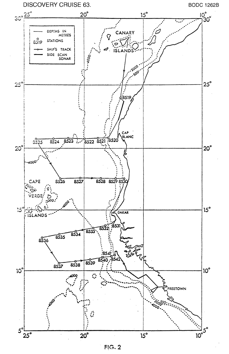
- References - including cruise tracks and cruise reports
Cruise Inventory Information
| Long name | RRS Discovery (74E3) cruise D63 |
|---|---|
| Short name | D63 |
| Objectives and Narrative |
1) To obtain a series of large-volume water samples, for studies of the trace element compostion and particulate matter geochemistry of some of the water masses of the North Atlantic
2) To obtain a series of sediment core samples, for geochemical sudies, along selected profiles off the North West African margin 3) To obtain samples of the benthos at 3000-4000m depth off the North West African margin. 4) To obtain a 24 hour series of biological samples from 300-600m depth at a single station off northern Spain 5) To obtain side scan sonar and telelsounder coverage of the African continental shelf |
| Ship | RRS Discovery |
| Departure Port | Barry, United Kingdom |
| Departure Date | 1974-06-12 |
| Arrival Port | Freetown, Sierra Leone |
| Arrival Date | 1974-07-14 |
| Principal Scientist(s) | Stephen E Calvert (Institute of Oceanographic Sciences Wormley Laboratory) |
| Responsible Organisation | Institute of Oceanographic Sciences Wormley Laboratory |
| Associated Project(s) | GATE |
| IHB Sea Areas Visited | North Atlantic Ocean, North East Atlantic Ocean (limit 40W) |
| Marsden Squares Visited | 110/145/146/181/2/38/39/74/75 |
| Work Area Description | |
| Unable to lookup cruise bounds at this time | |
| Work Area Bounding Polygon | |
| Southern Limit | unknown |
| Northern Limit | unknown |
| Western Limit | unknown |
| Eastern Limit | unknown |
Cruise Inventory Datasets
| Physical oceanography | |
|---|---|
| Water bottle stations |
Quantity:
number of stations =
13
Description: |
| Chemical oceanography | |
| Other chemical oceanographic measurements |
Quantity:
23
Description: sediment chemistry |
| Other chemical oceanographic measurements |
Quantity:
1
Description: particulate organic matter |
| Oxygen |
Quantity:
13
Description: |
| Silicate |
Quantity:
13
Description: |
| Trace elements |
Quantity:
13
Description: |
| Biology and fisheries | |
| Birds | Description: |
| Zooplankton |
Quantity:
19
Description: |
| Meteorology | |
| Incident radiation | Description: continuous solarimeter logging |
| Other meteorological measurements | Description: 2 min.values of temp.,wind and atm.pressure |
| Routine standard measurements | Description: 6 hourly;south of 20N(for GATE exercise) |
| Geology and geophysics | |
| Core - soft bottom |
Quantity:
number of cores =
24
Description: chemical analysis |
| Long/short range side scan sonar |
Quantity:
track kilometres =
644
Description: |
| Multi-beam echosounding |
Quantity:
track kilometres =
4862
Description: |
Cruise Inventory Mooring/Buoy Operations
No information on datasets is currently available
Summary of BODC Data Holdings for the Cruise
National Oceanographic Database
Summary
| # Series | Instrument Description | Parameters |
|---|---|---|
| 1 | CTD/STD cast |
Salinity of the water column Temperature of the water column Vertical spatial coordinates |
Note: Parameter terms are taken from the BODC Parameter Discovery Vocabulary XML (SKOS)
Full List
| BODC Reference | Instrument Description | Date/Time | Location | |
|---|---|---|---|---|
| 298003 | CTD/STD cast | 1974-06-14 00:00Z | 43° 50' N, 12° 24' W | Click for more |
Project Database
No data currently held for this cruise in the BODC Project Database
