BODC Cruise Metadata Report for RRS Challenger (74CH) cruise CH13/80
Introduction
This report collates information from the BODC cruise inventory and oceanographic databases. It presents
- Cruise Inventory Information
- A summary of BODC data holdings for the cruise from the
- References - including cruise tracks and cruise reports
Cruise Inventory Information
| Long name | RRS Challenger (74CH) cruise CH13/80 |
|---|---|
| Short name | CH13/80 |
| Objectives and Narrative |
The objectives of this cruise were:
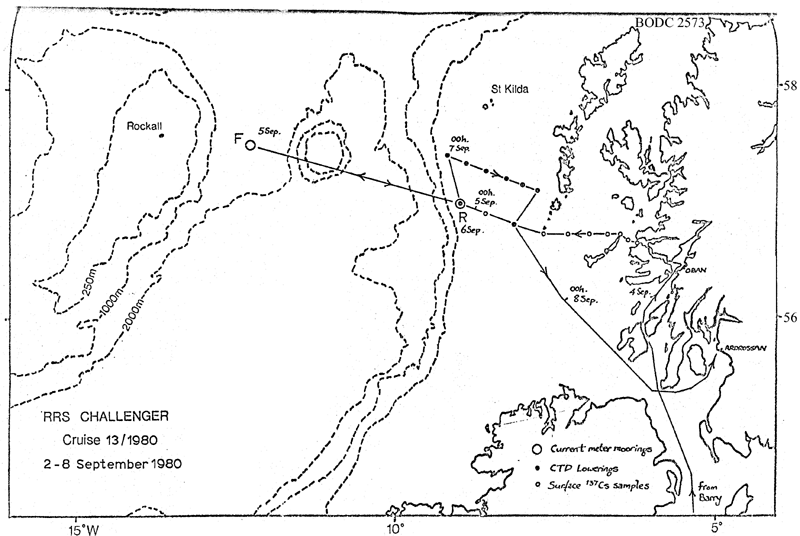
(1) To service current meter moorings on the shelf at 57N, 9W and in deep water at 57 deg 32 min N, 12 deg 17 min W. The shelf mooring was successfully recovered an redeployed, but the deep water mooring was found collapsed on the sea-bed and left to await dragging at a later date. (2) To work the western half of the Rockall via Anton Dohrn seamount CTD section. No time available. (3) To work E-W CTD sections on the shelf from St Kilda southwards with water sampling for oxygen and nutrients. One section to the west of South Uist worked. (4) To measure chlorophyll concentration over the continental shelf and shelf-edge. Continuous along-track measurements were made with bottle samples at the CTD stations. (5) To collect large volume surface water samples for radiocaesium analysis at standard stations across the Scottish shelf. Accomplished with CTD profiles on two of the ten sites. (6) To tow standard and fast plankton recorders for comparative tests. Accomplished. |
| Ship | RRS Challenger |
| Departure Port | Barry, United Kingdom |
| Departure Date | 1980-09-02 |
| Arrival Port | Ardrossan, United Kingdom |
| Arrival Date | 1980-09-08 |
| Principal Scientist(s) | David J Ellett (Scottish Marine Biological Association) |
| Responsible Organisation | Scottish Marine Biological Association |
| Associated Project(s) | Ellett Line |
| IHB Sea Areas Visited | Inner Seas off the West Coast of Scotland, North East Atlantic Ocean (limit 40W) |
| Marsden Squares Visited | 181;4/182;3 |
| Work Area Description | Rockall Channel/ Scottish Cont. Shelf |
| Unable to lookup cruise bounds at this time | |
| Work Area Bounding Polygon | |
| Southern Limit | unknown |
| Northern Limit | unknown |
| Western Limit | unknown |
| Eastern Limit | unknown |
Cruise Inventory Datasets
| Physical oceanography | |
|---|---|
| CTD stations |
Quantity:
number of stations =
8
Description: |
| Current meters |
Quantity:
number of deployments =
2
Description: 97 days |
| Chemical oceanography | |
| Isotopes |
Quantity:
number of samples =
10
Description: |
| Oxygen |
Quantity:
number of stations =
28
Description: |
| Biology and fisheries | |
| Gear research | Description: plankton recorder comparisons |
| Phytoplankton |
Quantity:
number of samples =
35
Description: |
| Phytoplankton pigs (eg chlorophyll, fluorescence) | Description: Chlorophyll (continuous sampling) |
| Phytoplankton pigs (eg chlorophyll, fluorescence) |
Quantity:
number of samples =
35
Description: |
| Zooplankton |
Quantity:
number of samples =
35
Description: |
Cruise Inventory Mooring/Buoy Operations
No information on datasets is currently available
Summary of BODC Data Holdings for the Cruise
National Oceanographic Database
Summary
| # Series | Instrument Description | Parameters |
|---|---|---|
| 8 | CTD/STD cast |
Salinity of the water column Temperature of the water column Vertical spatial coordinates |
Note: Parameter terms are taken from the BODC Parameter Discovery Vocabulary XML (SKOS)
Full List
| BODC Reference | Instrument Description | Date/Time | Location | |
|---|---|---|---|---|
| 186756 | CTD/STD cast | 1980-09-06 22:58Z | 57° 25' N, 9° 12' W | Click for more |
| 186768 | CTD/STD cast | 1980-09-07 01:19Z | 57° 21' N, 8° 54' W | Click for more |
| 186781 | CTD/STD cast | 1980-09-07 03:36Z | 57° 16' N, 8° 38' W | Click for more |
| 186793 | CTD/STD cast | 1980-09-07 05:51Z | 57° 13' N, 8° 19' W | Click for more |
| 186800 | CTD/STD cast | 1980-09-07 07:53Z | 57° 10' N, 8° 3' W | Click for more |
| 186812 | CTD/STD cast | 1980-09-07 09:47Z | 57° 7' N, 7° 48' W | Click for more |
| 186824 | CTD/STD cast | 1980-09-07 11:30Z | 57° 4' N, 7° 33' W | Click for more |
| 186836 | CTD/STD cast | 1980-09-07 16:50Z | 56° 50' N, 7° 57' W | Click for more |
Project Database
No data currently held for this cruise in the BODC Project Database
