BODC Cruise Metadata Report for RRS Challenger (74CH) cruise CH2/81
Introduction
This report collates information from the BODC cruise inventory and oceanographic databases. It presents
- Cruise Inventory Information
- A summary of BODC data holdings for the cruise from the
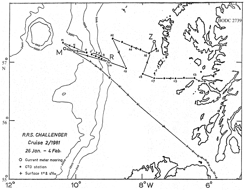
- References - including cruise tracks and cruise reports
Cruise Inventory Information
| Long name | RRS Challenger (74CH) cruise CH2/81 |
|---|---|
| Short name | CH2/81 |
| Objectives and Narrative |
The objectives of this cruise were:
(1) To service current meter moorings at stations M, (deep water: 57 deg 18 min N, 10 deg 23 min W) and R (shelf: 57N, 9W) and re-lay the mooring at F (deep water: 57.5N, 12.25W. Mooring at R recovered and re-laid: mooring at M recovered: no work at F. (2) To work the DML Rockall via Anton Dohrn Seamount (Ellett Line) CTD section and other sections across the Rockall Channel. Stations R (shelf) to M (deep water between the slope and the seamount) of the primary section worked plus a section across the shelf west of South Uist. (3) To deploy a corrosion potential current meter mooring off South Uist. Accomplished. (4) To collect large-volume surface water samples for radiocaesium analysis, accompanied by CTD profiles, at stations across the Scottish continental shelf. Accomplished with CTD profiles at all but one station. |
| Ship | RRS Challenger |
| Departure Port | Dunstaffnage, United Kingdom |
| Departure Date | 1981-01-26 |
| Arrival Port | Barry, United Kingdom |
| Arrival Date | 1981-02-04 |
| Principal Scientist(s) | David J Ellett (Scottish Marine Biological Association) |
| Responsible Organisation | Scottish Marine Biological Association |
| Associated Project(s) | |
| IHB Sea Areas Visited | North East Atlantic Ocean (limit 40W) |
| Marsden Squares Visited | 181;466/181;467/181;477/181;479/182;370 |
| Work Area Description | North Atlantic |
| Unable to lookup cruise bounds at this time | |
| Work Area Bounding Polygon | |
| Southern Limit | unknown |
| Northern Limit | unknown |
| Western Limit | unknown |
| Eastern Limit | unknown |
Cruise Inventory Datasets
| Physical oceanography | |
|---|---|
| CTD stations |
Quantity:
number of stations =
21
Description: |
| Current meters |
Quantity:
number of stations =
2
Description: recovered after 114d and relaid;after 112d |
| Other physical oceanographic measurements |
Quantity:
number of deployments =
1
Description: corrosion potential c.m. |
| Water bottle stations |
Quantity:
number of samples =
16
Description: surface only |
| Chemical oceanography | |
| Radioactivity | Description: surface water samples collected for radio-caesium analysis. |
Cruise Inventory Mooring/Buoy Operations
No information on datasets is currently available
Summary of BODC Data Holdings for the Cruise
National Oceanographic Database
Summary
| # Series | Instrument Description | Parameters |
|---|---|---|
| 21 | CTD/STD cast |
Salinity of the water column Temperature of the water column Vertical spatial coordinates |
Note: Parameter terms are taken from the BODC Parameter Discovery Vocabulary XML (SKOS)
Full List
| BODC Reference | Instrument Description | Date/Time | Location | |
|---|---|---|---|---|
| 312502 | CTD/STD cast | 1981-01-27 15:38Z | 56° 40' N, 6° 16' W | Click for more |
| 312514 | CTD/STD cast | 1981-01-27 17:00Z | 56° 43' N, 6° 27' W | Click for more |
| 312526 | CTD/STD cast | 1981-01-27 18:45Z | 56° 43' N, 6° 43' W | Click for more |
| 312538 | CTD/STD cast | 1981-01-27 20:22Z | 56° 43' N, 7° 0' W | Click for more |
| 312551 | CTD/STD cast | 1981-01-27 22:50Z | 56° 43' N, 7° 19' W | Click for more |
| 312563 | CTD/STD cast | 1981-01-28 03:38Z | 56° 46' N, 8° 0' W | Click for more |
| 312575 | CTD/STD cast | 1981-01-28 15:40Z | 57° 12' N, 7° 34' W | Click for more |
| 312587 | CTD/STD cast | 1981-01-28 17:30Z | 57° 7' N, 7° 49' W | Click for more |
| 312599 | CTD/STD cast | 1981-01-28 19:55Z | 57° 12' N, 8° 4' W | Click for more |
| 312606 | CTD/STD cast | 1981-01-28 20:38Z | 57° 13' N, 8° 19' W | Click for more |
| 312618 | CTD/STD cast | 1981-01-28 22:41Z | 57° 18' N, 8° 37' W | Click for more |
| 312631 | CTD/STD cast | 1981-01-29 00:43Z | 57° 22' N, 8° 54' W | Click for more |
| 312643 | CTD/STD cast | 1981-01-29 10:16Z | 56° 52' N, 8° 30' W | Click for more |
| 312655 | CTD/STD cast | 1981-01-29 21:13Z | 57° 0' N, 9° 0' W | Click for more |
| 312667 | CTD/STD cast | 1981-01-29 22:37Z | 57° 3' N, 9° 13' W | Click for more |
| 312679 | CTD/STD cast | 1981-01-29 23:40Z | 57° 4' N, 9° 19' W | Click for more |
| 312680 | CTD/STD cast | 1981-01-30 00:42Z | 57° 6' N, 9° 25' W | Click for more |
| 312692 | CTD/STD cast | 1981-01-30 02:40Z | 57° 7' N, 9° 33' W | Click for more |
| 312711 | CTD/STD cast | 1981-01-30 21:10Z | 57° 9' N, 9° 42' W | Click for more |
| 312723 | CTD/STD cast | 1981-01-30 23:31Z | 57° 13' N, 10° 3' W | Click for more |
| 312735 | CTD/STD cast | 1981-01-31 02:22Z | 57° 18' N, 10° 22' W | Click for more |
Project Database
No data currently held for this cruise in the BODC Project Database
