BODC Cruise Metadata Report for RRS Challenger (74CH) cruise CH6A/81
Introduction
This report collates information from the BODC cruise inventory and oceanographic databases. It presents
- Cruise Inventory Information
- A summary of BODC data holdings for the cruise from the
- References - including cruise tracks and cruise reports
Cruise Inventory Information
| Long name | RRS Challenger (74CH) cruise CH6A/81 |
|---|---|
| Short name | CH6A/81 |
| Objectives and Narrative |
The objectives of this cruise were:
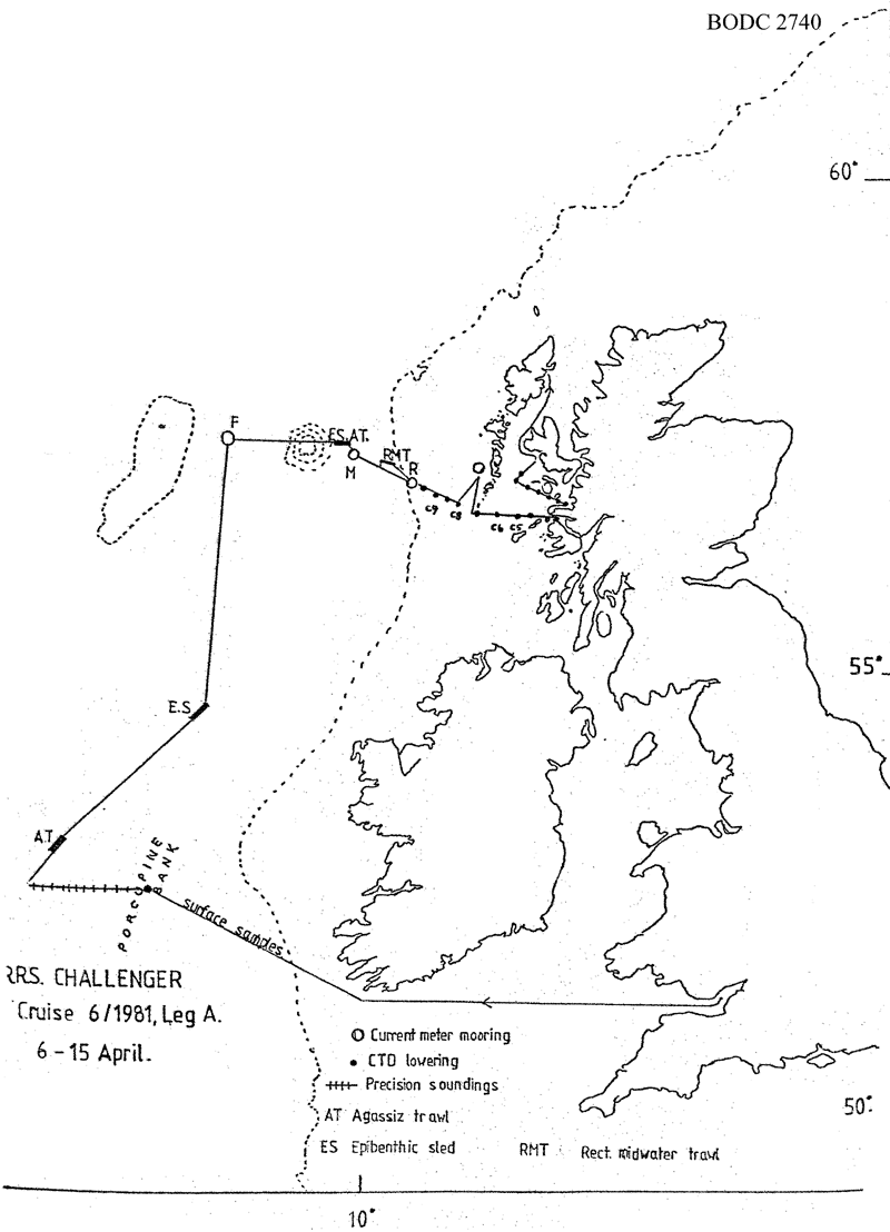
(1) To service current meter moorings at station R (shelf: 57N, 9W) and re-lay current meter moorings at stations M (deep water: 57 deg 18 min N, 10 deg 23 min W) and F (deep water: 57.5N, 12.25W). Accomplished. (2) To sample benthos in the southern and central Rockall Trough. Successful epibenthic sled and Agassiz trawl hauls at the SMBA permanent station and station M. (3) To recover the corrosion potential current meter mooring off South Uist. Accomplished. (4) To work the Rockall via Anton Dohrn Seamount (Ellett Line) CTD section. Stations R (shelf) to O (deep water between the slope and the seamount) of the section worked. Additional CTD sections on the shelf worked from Loch Moidart past Oigh Sgeir and at right angles into Loch Bracadale, Skye. (5) To determine bottom topography at future mooring sites to the west of Porcupine Bank. Accomplished. (6) To collect large-volume surface water samples for radiocaesium analysis, accompanied by CTD profiles, at stations across the Scottish continental shelf. Accomplished with CTD profiles on all but one station. |
| Ship | RRS Challenger |
| Departure Port | Barry, United Kingdom |
| Departure Date | 1981-04-06 |
| Arrival Port | Stornoway, United Kingdom |
| Arrival Date | 1981-04-15 |
| Principal Scientist(s) | David J Ellett (Scottish Marine Biological Association) |
| Responsible Organisation | Scottish Marine Biological Association |
| Associated Project(s) | |
| IHB Sea Areas Visited | Inner Seas off the West Coast of Scotland, North East Atlantic Ocean (limit 40W) |
| Marsden Squares Visited | 181;121/181;4/182;142/182;370/182;476/182;477/182;478/182;479 |
| Work Area Description | Rockall Channel/ Scottish Cont. Shelf |
| Unable to lookup cruise bounds at this time | |
| Work Area Bounding Polygon | |
| Southern Limit | unknown |
| Northern Limit | unknown |
| Western Limit | unknown |
| Eastern Limit | unknown |
Cruise Inventory Datasets
| Physical oceanography | |
|---|---|
| CTD stations |
Quantity:
number of stations =
29
Description: |
| Current meters |
Quantity:
number of stations =
1
Description: mooring(2 c.m.)recovered and not relaid;36 days |
| Other physical oceanographic measurements |
Quantity:
number of deployments =
75
Description: one corrosion potential c.m. |
| Chemical oceanography | |
| Radioactivity |
Quantity:
number of samples =
10
Description: radionuclides |
| Biology and fisheries | |
| Zoobenthos |
Quantity:
number of hauls =
2
Description: survey:taxonomy,population |
| Zooplankton |
Quantity:
number of hauls =
1
Description: |
Cruise Inventory Mooring/Buoy Operations
No information on datasets is currently available
Summary of BODC Data Holdings for the Cruise
National Oceanographic Database
Summary
| # Series | Instrument Description | Parameters |
|---|---|---|
| 29 | CTD/STD cast |
Salinity of the water column Temperature of the water column Vertical spatial coordinates |
Note: Parameter terms are taken from the BODC Parameter Discovery Vocabulary XML (SKOS)
Full List
| BODC Reference | Instrument Description | Date/Time | Location | |
|---|---|---|---|---|
| 187840 | CTD/STD cast | 1981-04-08 12:43Z | 52° 29' N, 13° 59' W | Click for more |
| 187852 | CTD/STD cast | 1981-04-13 00:37Z | 57° 9' N, 9° 42' W | Click for more |
| 187864 | CTD/STD cast | 1981-04-13 02:22Z | 57° 7' N, 9° 33' W | Click for more |
| 187876 | CTD/STD cast | 1981-04-13 03:54Z | 57° 6' N, 9° 25' W | Click for more |
| 187888 | CTD/STD cast | 1981-04-13 05:02Z | 57° 4' N, 9° 18' W | Click for more |
| 187907 | CTD/STD cast | 1981-04-13 06:01Z | 57° 3' N, 9° 13' W | Click for more |
| 187919 | CTD/STD cast | 1981-04-13 07:32Z | 57° 0' N, 9° 0' W | Click for more |
| 187920 | CTD/STD cast | 1981-04-13 10:09Z | 56° 57' N, 8° 46' W | Click for more |
| 187932 | CTD/STD cast | 1981-04-13 11:39Z | 56° 52' N, 8° 29' W | Click for more |
| 187944 | CTD/STD cast | 1981-04-13 13:00Z | 56° 52' N, 8° 29' W | Click for more |
| 187956 | CTD/STD cast | 1981-04-13 21:30Z | 56° 47' N, 8° 0' W | Click for more |
| 187968 | CTD/STD cast | 1981-04-13 23:09Z | 56° 43' N, 7° 40' W | Click for more |
| 187981 | CTD/STD cast | 1981-04-14 00:43Z | 56° 43' N, 7° 19' W | Click for more |
| 187993 | CTD/STD cast | 1981-04-14 02:19Z | 56° 43' N, 7° 0' W | Click for more |
| 188007 | CTD/STD cast | 1981-04-14 03:29Z | 56° 43' N, 6° 45' W | Click for more |
| 188019 | CTD/STD cast | 1981-04-14 05:00Z | 56° 44' N, 6° 27' W | Click for more |
| 188020 | CTD/STD cast | 1981-04-14 06:06Z | 56° 41' N, 6° 17' W | Click for more |
| 188032 | CTD/STD cast | 1981-04-14 09:45Z | 56° 48' N, 5° 56' W | Click for more |
| 188044 | CTD/STD cast | 1981-04-14 10:40Z | 56° 49' N, 6° 4' W | Click for more |
| 188056 | CTD/STD cast | 1981-04-14 11:25Z | 56° 51' N, 6° 11' W | Click for more |
| 188068 | CTD/STD cast | 1981-04-14 12:16Z | 56° 54' N, 6° 20' W | Click for more |
| 188081 | CTD/STD cast | 1981-04-14 13:05Z | 56° 56' N, 6° 28' W | Click for more |
| 188093 | CTD/STD cast | 1981-04-14 14:04Z | 56° 59' N, 6° 37' W | Click for more |
| 188100 | CTD/STD cast | 1981-04-14 15:16Z | 57° 1' N, 6° 49' W | Click for more |
| 188112 | CTD/STD cast | 1981-04-14 16:07Z | 57° 4' N, 6° 43' W | Click for more |
| 188124 | CTD/STD cast | 1981-04-14 16:55Z | 57° 10' N, 6° 39' W | Click for more |
| 188136 | CTD/STD cast | 1981-04-14 17:56Z | 57° 13' N, 6° 35' W | Click for more |
| 188148 | CTD/STD cast | 1981-04-14 18:32Z | 57° 15' N, 6° 33' W | Click for more |
| 188161 | CTD/STD cast | 1981-04-14 19:02Z | 57° 18' N, 6° 31' W | Click for more |
Project Database
No data currently held for this cruise in the BODC Project Database
