BODC Cruise Metadata Report for RRS Challenger (74CH) cruise CH15/81
Introduction
This report collates information from the BODC cruise inventory and oceanographic databases. It presents
- Cruise Inventory Information
- A summary of BODC data holdings for the cruise from the
- References - including cruise tracks and cruise reports
Cruise Inventory Information
| Long name | RRS Challenger (74CH) cruise CH15/81 |
|---|---|
| Short name | CH15/81 |
| Objectives and Narrative |
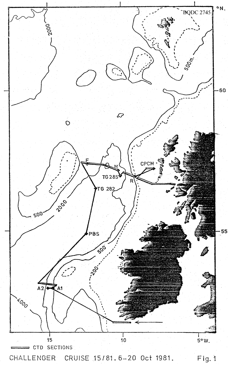
1. To service SMBA current meter moorings at stations F (57ş 30'N, 12ş 15'W), M (57ş 18'N, 10ş 23'W) and R (57şN, 9şW).
2. To lay two bottom current meter moorings to the west of Porcupine Bank for joint SMBA/MAFF studies at positions A1-52ş 30'N. 14ş 46'W. (500m.) and A2-52ş 30'NN. 14ş 54'W. (750m). 3. To work the Anton Dohrn Seamount (Ellett Line) CTD section and other sections as time permits. 4. Service the toroidal mooring at the fouling studies site west of S. Uist. Position at 57ş 18.7'N, 7ş 38.7W. 5. To continue seasonal benthos studies in the south and central Rockall Channel at 54ş 40'N 12ş 16'W., Epibenthic Sledge Haul for one hour. Near station M, priority given to Agassiz trawl but if time allows - an epibenthic sledge haul will be done. 6. To lay two Bidston pressure recorders in the vicinity of mooring M and at the foot of the continental slope. 7. To collect Clarke-Bumpus plankton net samples and CTD profiles across the slope region of S.W Ireland for the University College of Galway. 8. To collect 50 litre water samples for radiocaesium analysis and CTD profiles at ten standard positions between the shelf-edge and the Sound of Mull. |
| Ship | RRS Challenger |
| Departure Port | Barry, United Kingdom |
| Departure Date | 1981-10-06 |
| Arrival Port | Ardrossan, United Kingdom |
| Arrival Date | 1981-10-20 |
| Principal Scientist(s) | Anton Edwards (Scottish Marine Biological Association) |
| Responsible Organisation | Scottish Marine Biological Association |
| Associated Project(s) | |
| IHB Sea Areas Visited | Inner Seas off the West Coast of Scotland, North East Atlantic Ocean (limit 40W) |
| Marsden Squares Visited | 181;219/181;4/182;110/182;124/182;225/182;361/182;370/182;371/182;372 |
| Work Area Description | N.E. Atlantic |
| Unable to lookup cruise bounds at this time | |
| Work Area Bounding Polygon | |
| Southern Limit | unknown |
| Northern Limit | unknown |
| Western Limit | unknown |
| Eastern Limit | unknown |
Cruise Inventory Datasets
| Physical oceanography | |
|---|---|
| CTD stations |
Quantity:
number of stations =
37
Description: noisy salinity |
| Current meters |
Quantity:
number of stations =
3
Description: 156d;157d;67d |
| Sea level (inc. bot. press., inverted echosounder) | Description: pressure records |
| Water bottle stations |
Quantity:
number of stations =
30
Description: S surface only |
| Chemical oceanography | |
| Radioactivity | Description: water samples for radio-caesium monitoring. |
Cruise Inventory Mooring/Buoy Operations
No information on datasets is currently available
Summary of BODC Data Holdings for the Cruise
National Oceanographic Database
Summary
| # Series | Instrument Description | Parameters |
|---|---|---|
| 36 | CTD/STD cast |
Salinity of the water column Temperature of the water column Vertical spatial coordinates |
Note: Parameter terms are taken from the BODC Parameter Discovery Vocabulary XML (SKOS)
Full List
| BODC Reference | Instrument Description | Date/Time | Location | |
|---|---|---|---|---|
| 186965 | CTD/STD cast | 1981-10-08 08:22Z | 51° 20' N, 9° 20' W | Click for more |
| 186977 | CTD/STD cast | 1981-10-08 12:05Z | 51° 17' N, 9° 49' W | Click for more |
| 186989 | CTD/STD cast | 1981-10-08 15:28Z | 51° 19' N, 10° 13' W | Click for more |
| 186990 | CTD/STD cast | 1981-10-08 20:25Z | 51° 22' N, 10° 35' W | Click for more |
| 187004 | CTD/STD cast | 1981-10-10 18:33Z | 52° 34' N, 14° 30' W | Click for more |
| 187016 | CTD/STD cast | 1981-10-10 19:10Z | 52° 36' N, 14° 40' W | Click for more |
| 187028 | CTD/STD cast | 1981-10-10 21:35Z | 52° 37' N, 14° 51' W | Click for more |
| 187041 | CTD/STD cast | 1981-10-10 23:00Z | 52° 37' N, 15° 0' W | Click for more |
| 187053 | CTD/STD cast | 1981-10-11 01:57Z | 52° 39' N, 15° 10' W | Click for more |
| 187065 | CTD/STD cast | 1981-10-11 02:47Z | 52° 39' N, 15° 21' W | Click for more |
| 187077 | CTD/STD cast | 1981-10-11 05:00Z | 52° 40' N, 15° 30' W | Click for more |
| 187089 | CTD/STD cast | 1981-10-11 07:30Z | 52° 42' N, 15° 40' W | Click for more |
| 187090 | CTD/STD cast | 1981-10-14 00:53Z | 57° 31' N, 12° 37' W | Click for more |
| 187108 | CTD/STD cast | 1981-10-14 16:59Z | 57° 30' N, 12° 13' W | Click for more |
| 187121 | CTD/STD cast | 1981-10-14 21:40Z | 57° 28' N, 11° 32' W | Click for more |
| 187133 | CTD/STD cast | 1981-10-14 23:26Z | 57° 28' N, 11° 18' W | Click for more |
| 187145 | CTD/STD cast | 1981-10-15 01:00Z | 57° 27' N, 11° 4' W | Click for more |
| 187157 | CTD/STD cast | 1981-10-15 02:25Z | 57° 24' N, 10° 52' W | Click for more |
| 187169 | CTD/STD cast | 1981-10-15 04:10Z | 57° 22' N, 10° 40' W | Click for more |
| 187170 | CTD/STD cast | 1981-10-15 23:00Z | 57° 15' N, 10° 19' W | Click for more |
| 187182 | CTD/STD cast | 1981-10-16 18:34Z | 57° 13' N, 10° 3' W | Click for more |
| 187194 | CTD/STD cast | 1981-10-17 00:41Z | 57° 9' N, 9° 42' W | Click for more |
| 187201 | CTD/STD cast | 1981-10-17 02:05Z | 57° 7' N, 9° 33' W | Click for more |
| 187213 | CTD/STD cast | 1981-10-17 15:05Z | 57° 6' N, 9° 25' W | Click for more |
| 187225 | CTD/STD cast | 1981-10-17 16:53Z | 57° 4' N, 9° 19' W | Click for more |
| 187237 | CTD/STD cast | 1981-10-17 18:39Z | 57° 3' N, 9° 13' W | Click for more |
| 187249 | CTD/STD cast | 1981-10-17 20:30Z | 57° 1' N, 9° 6' W | Click for more |
| 187250 | CTD/STD cast | 1981-10-17 22:13Z | 57° 0' N, 9° 1' W | Click for more |
| 187262 | CTD/STD cast | 1981-10-18 12:45Z | 57° 18' N, 7° 44' W | Click for more |
| 187274 | CTD/STD cast | 1981-10-18 14:06Z | 57° 19' N, 7° 55' W | Click for more |
| 187286 | CTD/STD cast | 1981-10-18 15:42Z | 57° 18' N, 8° 3' W | Click for more |
| 187298 | CTD/STD cast | 1981-10-19 17:50Z | 56° 43' N, 7° 0' W | Click for more |
| 187305 | CTD/STD cast | 1981-10-19 19:19Z | 56° 43' N, 6° 44' W | Click for more |
| 187317 | CTD/STD cast | 1981-10-19 20:55Z | 56° 43' N, 6° 27' W | Click for more |
| 187329 | CTD/STD cast | 1981-10-19 21:53Z | 56° 41' N, 6° 18' W | Click for more |
| 187330 | CTD/STD cast | 1981-10-19 22:50Z | 56° 40' N, 6° 7' W | Click for more |
Project Database
No data currently held for this cruise in the BODC Project Database
