BODC Cruise Metadata Report for RV Cirolana (74CZ) cruise CIR6/81
Introduction
This report collates information from the BODC cruise inventory and oceanographic databases. It presents
- Cruise Inventory Information
- A summary of BODC data holdings for the cruise from the
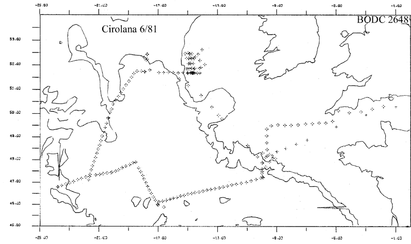
- References - including cruise tracks and cruise reports
Cruise Inventory Information
| Long name | RV Cirolana (74CZ) cruise CIR6/81 |
|---|---|
| Short name | CIR6/81 |
| Objectives and Narrative |
The aims of this cruise were:
(1) Recover 8-mooring array on the SW Approaches continental slope. Four recovered, but four lost. (2) Recover the NEADS-6 mooring from 52.5N, 17.75W. Accomplished. (3) Survey midwater nepheloid layers along the Porcupine Bank Slope using CTD, nephelometer, transmissometer and HIAC. Accomplished. (4) Lay and recover a short-term mooring of thermistors and current meters on a site of slope erosion on the Porcupine Bank. Deployed for three days. (5) Establish a working shipboard system for bulk radiochemical sampling. Accomplished. (6) Lay bottom current meter moorings to the SW of Rockall Bank and east of the mid-Atlantic Ridge. Four moorings deployed to be recovered on CIR9/81. (7) Deploy abyssal fish traps. Four deployments yielding 7 Coryphanoides and a few amphipods. (8) Make continuous surface chlorophyll and nutrient measurements. Accomplished. (9) Sample mackerel post-larvae using a neuston net. Accomplished. (10) Recover the Nab Tower current meter mooring. Accomplished. (11) Take regular XBT profiles whilst underway. Accomplished. (12) Take surface samples for radiocaesium analysis. Accomplished. |
| Ship | RV Cirolana |
| Departure Port | Grimsby, United Kingdom |
| Departure Date | 1981-06-03 |
| Arrival Port | Grimsby, United Kingdom |
| Arrival Date | 1981-06-30 |
| Principal Scientist(s) | Robert R Dickson (Ministry of Agriculture, Fisheries and Food Lowestoft Fisheries Laboratory) |
| Responsible Organisation | Ministry of Agriculture, Fisheries and Food Lowestoft Fisheries Laboratory |
| Associated Project(s) | |
| IHB Sea Areas Visited | North East Atlantic Ocean (limit 40W) |
| Marsden Squares Visited | 146;3/146;4/147;3/181;1/181;2/182;1/182;2/183;1 |
| Work Area Description | N.E. Atlantic |
| Unable to lookup cruise bounds at this time | |
| Work Area Bounding Polygon | |
| Southern Limit | unknown |
| Northern Limit | unknown |
| Western Limit | unknown |
| Eastern Limit | unknown |
Cruise Inventory Datasets
| Physical oceanography | |
|---|---|
| Bathythermograph |
Quantity:
number of profiles =
93
Description: |
| CTD stations |
Quantity:
number of stations =
32
Description: |
| Current meters |
Quantity:
number of deployments =
8
Description: 1 year |
| Other physical oceanographic measurements |
Quantity:
number of stations =
32
Description: particle counts |
| Surface measurements underway (T,S) | Description: T only |
| Transparency (eg transmissometer) |
Quantity:
number of stations =
7
Description: |
| Transparency (eg transmissometer) |
Quantity:
number of stations =
25
Description: nephelometer |
| Chemical oceanography | |
| Isotopes |
Quantity:
number of stations =
10
Description: |
| Nitrate |
Quantity:
number of stations =
1
Description: |
| Phosphate |
Quantity:
number of stations =
1
Description: |
| Silicate |
Quantity:
number of stations =
10
Description: |
| Biology and fisheries | |
| Neuston |
Quantity:
number of hauls =
49
Description: |
| Other biological/fisheries measurement |
Quantity:
number of deployments =
4
Description: deep-sea fish traps |
| Phytoplankton pigs (eg chlorophyll, fluorescence) | Description: |
| Meteorology | |
| Occasional standard measurements | Description: |
| Geology and geophysics | |
| Core - soft bottom |
Quantity:
number of cores =
1
Description: |
Cruise Inventory Mooring/Buoy Operations
No information on datasets is currently available
Summary of BODC Data Holdings for the Cruise
National Oceanographic Database
Summary
| # Series | Instrument Description | Parameters |
|---|---|---|
| 31 | CTD/STD cast |
Salinity of the water column Temperature of the water column Vertical spatial coordinates |
Note: Parameter terms are taken from the BODC Parameter Discovery Vocabulary XML (SKOS)
Full List
| BODC Reference | Instrument Description | Date/Time | Location | |
|---|---|---|---|---|
| 325451 | CTD/STD cast | 1981-06-19 21:00Z | 51° 45' N, 17° 55' W | Click for more |
| 325463 | CTD/STD cast | 1981-06-15 12:59Z | 51° 42' N, 14° 32' W | Click for more |
| 325475 | CTD/STD cast | 1981-06-15 14:28Z | 51° 43' N, 14° 39' W | Click for more |
| 325487 | CTD/STD cast | 1981-06-15 16:02Z | 51° 42' N, 14° 50' W | Click for more |
| 325499 | CTD/STD cast | 1981-06-15 18:40Z | 51° 41' N, 15° 0' W | Click for more |
| 325506 | CTD/STD cast | 1981-06-15 20:38Z | 51° 42' N, 14° 44' W | Click for more |
| 325518 | CTD/STD cast | 1981-06-16 07:45Z | 51° 52' N, 14° 44' W | Click for more |
| 325531 | CTD/STD cast | 1981-06-16 09:03Z | 51° 52' N, 14° 51' W | Click for more |
| 325543 | CTD/STD cast | 1981-06-16 10:26Z | 51° 52' N, 14° 59' W | Click for more |
| 325555 | CTD/STD cast | 1981-06-16 12:31Z | 51° 52' N, 15° 6' W | Click for more |
| 325567 | CTD/STD cast | 1981-06-16 14:56Z | 52° 4' N, 14° 56' W | Click for more |
| 325579 | CTD/STD cast | 1981-06-16 17:25Z | 52° 5' N, 14° 52' W | Click for more |
| 325580 | CTD/STD cast | 1981-06-16 18:44Z | 52° 5' N, 14° 48' W | Click for more |
| 325592 | CTD/STD cast | 1981-06-16 20:00Z | 52° 5' N, 14° 38' W | Click for more |
| 325611 | CTD/STD cast | 1981-06-16 22:40Z | 52° 18' N, 14° 35' W | Click for more |
| 325623 | CTD/STD cast | 1981-06-17 06:27Z | 52° 18' N, 14° 45' W | Click for more |
| 325635 | CTD/STD cast | 1981-06-17 07:27Z | 52° 18' N, 14° 49' W | Click for more |
| 325647 | CTD/STD cast | 1981-06-17 08:43Z | 52° 18' N, 14° 57' W | Click for more |
| 325659 | CTD/STD cast | 1981-06-17 10:16Z | 52° 17' N, 15° 4' W | Click for more |
| 325660 | CTD/STD cast | 1981-06-17 12:41Z | 52° 28' N, 15° 10' W | Click for more |
| 325672 | CTD/STD cast | 1981-06-17 14:33Z | 52° 30' N, 14° 59' W | Click for more |
| 325684 | CTD/STD cast | 1981-06-17 16:08Z | 52° 28' N, 14° 51' W | Click for more |
| 325696 | CTD/STD cast | 1981-06-17 19:50Z | 52° 28' N, 14° 54' W | Click for more |
| 325703 | CTD/STD cast | 1981-06-17 21:08Z | 52° 28' N, 14° 43' W | Click for more |
| 325715 | CTD/STD cast | 1981-06-18 06:41Z | 51° 42' N, 14° 39' W | Click for more |
| 325727 | CTD/STD cast | 1981-06-18 08:12Z | 51° 42' N, 14° 36' W | Click for more |
| 325739 | CTD/STD cast | 1981-06-18 10:45Z | 51° 42' N, 14° 31' W | Click for more |
| 325740 | CTD/STD cast | 1981-06-18 13:07Z | 51° 42' N, 14° 39' W | Click for more |
| 325752 | CTD/STD cast | 1981-06-18 14:02Z | 51° 42' N, 14° 45' W | Click for more |
| 325764 | CTD/STD cast | 1981-06-18 14:57Z | 51° 42' N, 14° 49' W | Click for more |
| 325776 | CTD/STD cast | 1981-06-18 16:07Z | 51° 41' N, 15° 0' W | Click for more |
Project Database
No data currently held for this cruise in the BODC Project Database
