BODC Cruise Metadata Report for RRS Challenger (74CH) cruise CH7A/82
Introduction
This report collates information from the BODC cruise inventory and oceanographic databases. It presents
- Cruise Inventory Information
- A summary of BODC data holdings for the cruise from the
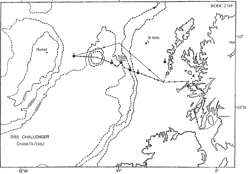
- References - including cruise tracks and cruise reports
Cruise Inventory Information
| Long name | RRS Challenger (74CH) cruise CH7A/82 |
|---|---|
| Short name | CH7A/82 |
| Objectives and Narrative |
The objectives of this cruise were:
(1) To service or deploy current meter moorings on 6 SMBA stations, including the long-term stations F, M and R. Four stations turned around, one (F) recovered but not re-laid. (2) To deploy and IOS Bidston tide gauge at 57 deg 20 min N, 9 deg 54 min W. Accomplished. (3) To work the Rockall via Anton Dohrn Seamount (Ellett Line) and other CTD sections. Worked as far as station F (between the seamount and Rockall). (4) To recover fouling mooring from west of South Uist. Not done due to weather. (5) To collect large-volume water samples for radiocaesium analysis with CTD profiles on stations. Accomplished. (6) To measure chlorophyll concentrations on the shelf and over the shelf edge. Accomplished by bottle profiles and continuous underway fluorometer. (7) To work CTD sections in the Sea of the Hebrides. No time available. |
| Ship | RRS Challenger |
| Departure Port | Ardrossan, United Kingdom |
| Departure Date | 1982-04-26 |
| Arrival Port | Ardrossan, United Kingdom |
| Arrival Date | 1982-05-05 |
| Principal Scientist(s) | Roy Bowers (Scottish Marine Biological Association) |
| Responsible Organisation | Scottish Marine Biological Association |
| Associated Project(s) | |
| IHB Sea Areas Visited | North East Atlantic Ocean (limit 40W) |
| Marsden Squares Visited | 181;466/181;467/181;479/182;370/182;372 |
| Work Area Description | N. Atlantic Ocean |
| Unable to lookup cruise bounds at this time | |
| Work Area Bounding Polygon | |
| Southern Limit | unknown |
| Northern Limit | unknown |
| Western Limit | unknown |
| Eastern Limit | unknown |
Cruise Inventory Datasets
| Physical oceanography | |
|---|---|
| CTD stations |
Quantity:
number of stations =
29
Description: noisy salinity |
| Current meters | Description: 11 c.m.deployed;11 c.m.recovered;85 days |
| Sea level (inc. bot. press., inverted echosounder) |
Quantity:
number of deployments =
1
Description: tide gauge laid |
| Water bottle stations | Description: surface only |
| Biology and fisheries | |
| Other biological/fisheries measurement |
Quantity:
number of stations =
2
Description: attached plants and algae |
| Other biological/fisheries measurement |
Quantity:
number of stations =
2
Description: borers and foulers |
| Phytoplankton pigs (eg chlorophyll, fluorescence) | Description: chlorophyll(cont.surface recording) |
Cruise Inventory Mooring/Buoy Operations
No information on datasets is currently available
Summary of BODC Data Holdings for the Cruise
National Oceanographic Database
Summary
| # Series | Instrument Description | Parameters |
|---|---|---|
| 29 | CTD/STD cast |
Salinity of the water column Temperature of the water column Vertical spatial coordinates |
Note: Parameter terms are taken from the BODC Parameter Discovery Vocabulary XML (SKOS)
Full List
| BODC Reference | Instrument Description | Date/Time | Location | |
|---|---|---|---|---|
| 189047 | CTD/STD cast | 1982-04-26 04:02Z | 56° 40' N, 6° 16' W | Click for more |
| 189059 | CTD/STD cast | 1982-04-26 05:33Z | 56° 40' N, 6° 17' W | Click for more |
| 189060 | CTD/STD cast | 1982-04-26 11:08Z | 56° 45' N, 6° 28' W | Click for more |
| 189072 | CTD/STD cast | 1982-04-26 12:38Z | 56° 44' N, 6° 43' W | Click for more |
| 189084 | CTD/STD cast | 1982-04-26 14:40Z | 56° 43' N, 6° 58' W | Click for more |
| 189096 | CTD/STD cast | 1982-04-26 16:46Z | 56° 43' N, 7° 19' W | Click for more |
| 189103 | CTD/STD cast | 1982-04-26 18:57Z | 56° 43' N, 7° 42' W | Click for more |
| 189115 | CTD/STD cast | 1982-04-26 21:20Z | 56° 48' N, 8° 0' W | Click for more |
| 189127 | CTD/STD cast | 1982-04-26 23:08Z | 56° 51' N, 8° 19' W | Click for more |
| 189139 | CTD/STD cast | 1982-04-27 00:14Z | 56° 52' N, 8° 27' W | Click for more |
| 189140 | CTD/STD cast | 1982-04-27 01:55Z | 56° 56' N, 8° 45' W | Click for more |
| 189152 | CTD/STD cast | 1982-04-27 03:18Z | 56° 59' N, 8° 58' W | Click for more |
| 189164 | CTD/STD cast | 1982-04-27 05:06Z | 57° 2' N, 9° 12' W | Click for more |
| 189176 | CTD/STD cast | 1982-04-27 19:12Z | 57° 7' N, 9° 25' W | Click for more |
| 189188 | CTD/STD cast | 1982-04-27 22:08Z | 57° 9' N, 9° 42' W | Click for more |
| 189207 | CTD/STD cast | 1982-04-28 05:56Z | 57° 13' N, 10° 3' W | Click for more |
| 189219 | CTD/STD cast | 1982-04-28 06:23Z | 57° 13' N, 10° 3' W | Click for more |
| 189220 | CTD/STD cast | 1982-04-28 15:38Z | 57° 17' N, 10° 31' W | Click for more |
| 189232 | CTD/STD cast | 1982-04-29 07:05Z | 57° 20' N, 10° 33' W | Click for more |
| 189244 | CTD/STD cast | 1982-04-29 09:20Z | 57° 22' N, 10° 40' W | Click for more |
| 189256 | CTD/STD cast | 1982-04-29 11:08Z | 57° 22' N, 10° 40' W | Click for more |
| 189268 | CTD/STD cast | 1982-04-29 12:23Z | 57° 24' N, 10° 52' W | Click for more |
| 189281 | CTD/STD cast | 1982-04-29 15:02Z | 57° 27' N, 11° 5' W | Click for more |
| 189293 | CTD/STD cast | 1982-04-29 16:14Z | 57° 28' N, 11° 19' W | Click for more |
| 189300 | CTD/STD cast | 1982-04-29 17:36Z | 57° 28' N, 11° 25' W | Click for more |
| 189312 | CTD/STD cast | 1982-04-29 19:01Z | 57° 28' N, 11° 31' W | Click for more |
| 189324 | CTD/STD cast | 1982-04-30 09:13Z | 57° 28' N, 11° 37' W | Click for more |
| 189336 | CTD/STD cast | 1982-05-01 21:15Z | 57° 30' N, 12° 15' W | Click for more |
| 189348 | CTD/STD cast | 1982-05-02 00:22Z | 57° 29' N, 11° 51' W | Click for more |
Project Database
No data currently held for this cruise in the BODC Project Database
