BODC Cruise Metadata Report for RRS Challenger (74CH) cruise CH7B/82
Introduction
This report collates information from the BODC cruise inventory and oceanographic databases. It presents
- Cruise Inventory Information
- A summary of BODC data holdings for the cruise from the
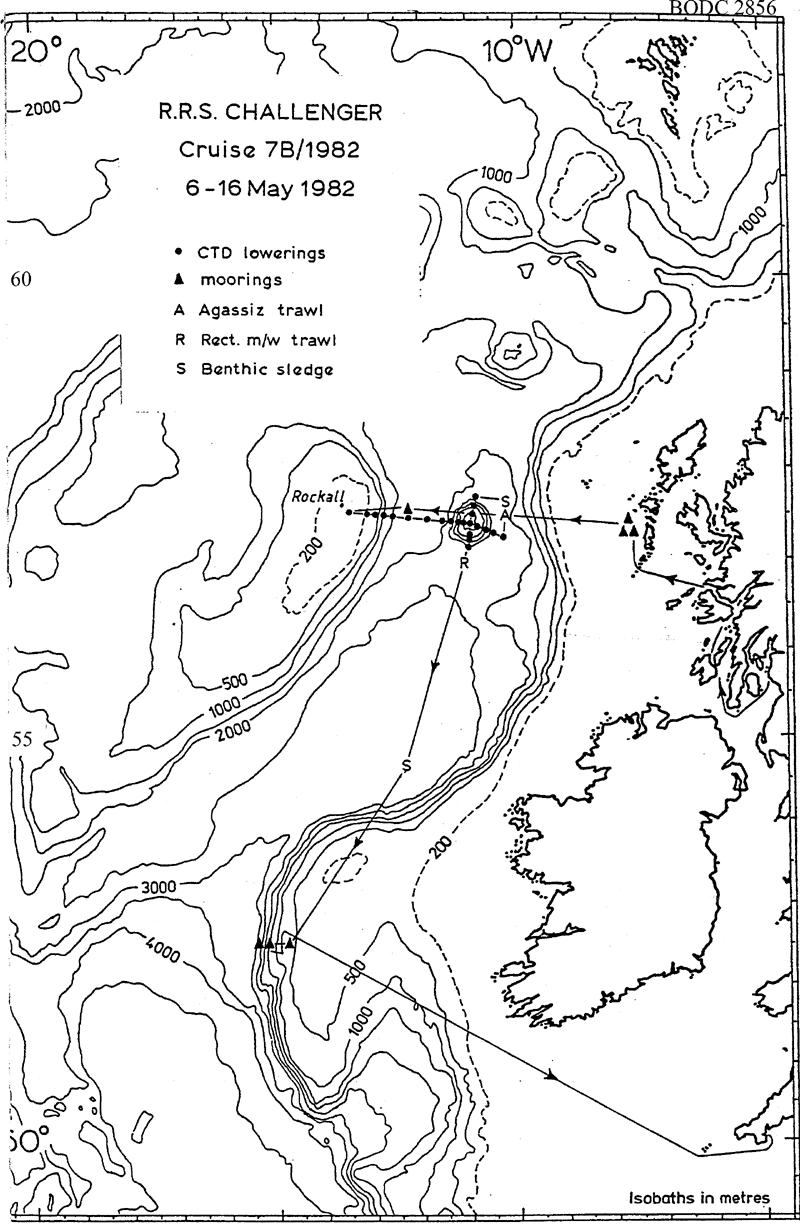
- References - including cruise tracks and cruise reports
Cruise Inventory Information
| Long name | RRS Challenger (74CH) cruise CH7B/82 |
|---|---|
| Short name | CH7B/82 |
| Objectives and Narrative |
The objectives of this cruise were:
(1) To deploy a current meter mooring at stations F (57.5N, 12.25W) and Z (57 deg 19 min N, 7 deg 39 min W). Accomplished. (2) To service MAFF moorings on the Porcupine slope at 52.5N. Recovered but not re-laid. (3) To work the western half of the Rockall via Anton Dohrn Seamount (Ellett Line) and other CTD sections. Main section from station A (east of the seamount) to M (Rockall) worked, plus a north-south section across the seamount. (4) To recover and service fouling moorings west of South Uist. Accomplished. (5) To make Agassiz trawl and benthic sledge hauls to the east of the Anton Dohrn Seamount and at the SMBA permanent benthos station (54.5N). Accomplished. (6) To work CTD sections in the Sea of the Hebrides. No time available. |
| Ship | RRS Challenger |
| Departure Port | Ardrossan, United Kingdom |
| Departure Date | 1982-05-06 |
| Arrival Port | Falmouth, United Kingdom |
| Arrival Date | 1982-05-16 |
| Principal Scientist(s) | David J Ellett (Scottish Marine Biological Association) |
| Responsible Organisation | Scottish Marine Biological Association |
| Associated Project(s) | |
| IHB Sea Areas Visited | North East Atlantic Ocean (limit 40W) |
| Marsden Squares Visited | 181;477/182;124/182;142/182;225/182;3 |
| Work Area Description | N. Atlantic Ocean |
| Unable to lookup cruise bounds at this time | |
| Work Area Bounding Polygon | |
| Southern Limit | unknown |
| Northern Limit | unknown |
| Western Limit | unknown |
| Eastern Limit | unknown |
Cruise Inventory Datasets
| Physical oceanography | |
|---|---|
| CTD stations |
Quantity:
number of stations =
24
Description: noisy salinity |
| Current meters | Description: 5 c.m.deployed;6 c.m.recovered;180 days |
| Water bottle stations | Description: surface only |
| Biology and fisheries | |
| Eggs and larvae | Description: |
| Gear research | Description: |
| Other biological/fisheries measurement | Description: attached plants and algae |
| Other biological/fisheries measurement | Description: borers and foulers |
| Other biological/fisheries measurement | Description: intertidal organisms |
| Zoobenthos | Description: survey:taxonomy,biomass determination,distribution |
| Zooplankton | Description: |
Cruise Inventory Mooring/Buoy Operations
No information on datasets is currently available
Summary of BODC Data Holdings for the Cruise
National Oceanographic Database
Summary
| # Series | Instrument Description | Parameters |
|---|---|---|
| 23 | CTD/STD cast |
Salinity of the water column Temperature of the water column Vertical spatial coordinates |
| 1 | CTD/STD cast |
Reference numbers Salinity of the water column Temperature of the water column Vertical spatial coordinates |
Note: Parameter terms are taken from the BODC Parameter Discovery Vocabulary XML (SKOS)
Full List
| BODC Reference | Instrument Description | Date/Time | Location | |
|---|---|---|---|---|
| 189361 | CTD/STD cast | 1982-05-08 16:37Z | 57° 37' N, 13° 37' W | Click for more |
| 189373 | CTD/STD cast | 1982-05-08 18:30Z | 57° 34' N, 13° 20' W | Click for more |
| 189385 | CTD/STD cast | 1982-05-08 20:10Z | 57° 33' N, 13° 0' W | Click for more |
| 189397 | CTD/STD cast | 1982-05-08 21:12Z | 57° 32' N, 12° 52' W | Click for more |
| 189404 | CTD/STD cast | 1982-05-08 22:58Z | 57° 31' N, 12° 37' W | Click for more |
| 189416 | CTD/STD cast | 1982-05-09 02:20Z | 57° 30' N, 12° 15' W | Click for more |
| 189428 | CTD/STD cast | 1982-05-09 05:15Z | 57° 30' N, 11° 50' W | Click for more |
| 189441 | CTD/STD cast | 1982-05-09 07:20Z | 57° 28' N, 11° 37' W | Click for more |
| 189453 | CTD/STD cast | 1982-05-09 08:56Z | 57° 28' N, 11° 31' W | Click for more |
| 189465 | CTD/STD cast | 1982-05-09 10:28Z | 57° 28' N, 11° 25' W | Click for more |
| 189477 | CTD/STD cast | 1982-05-09 11:59Z | 57° 28' N, 11° 19' W | Click for more |
| 189489 | CTD/STD cast | 1982-05-09 13:25Z | 57° 27' N, 11° 4' W | Click for more |
| 189490 | CTD/STD cast | 1982-05-09 15:08Z | 57° 24' N, 10° 52' W | Click for more |
| 189508 | CTD/STD cast | 1982-05-09 16:10Z | 57° 22' N, 10° 46' W | Click for more |
| 189521 | CTD/STD cast | 1982-05-09 17:17Z | 57° 22' N, 10° 40' W | Click for more |
| 189533 | CTD/STD cast | 1982-05-09 18:41Z | 57° 21' N, 10° 32' W | Click for more |
| 189545 | CTD/STD cast | 1982-05-09 20:40Z | 57° 18' N, 10° 22' W | Click for more |
| 189557 | CTD/STD cast | 1982-05-10 12:01Z | 57° 44' N, 10° 55' W | Click for more |
| 189569 | CTD/STD cast | 1982-05-10 15:46Z | 57° 40' N, 10° 51' W | Click for more |
| 189570 | CTD/STD cast | 1982-05-10 17:22Z | 57° 37' N, 10° 59' W | Click for more |
| 189582 | CTD/STD cast | 1982-05-10 20:55Z | 57° 16' N, 11° 11' W | Click for more |
| 189594 | CTD/STD cast | 1982-05-10 22:06Z | 57° 13' N, 11° 12' W | Click for more |
| 189601 | CTD/STD cast | 1982-05-10 23:31Z | 57° 9' N, 11° 13' W | Click for more |
| 189613 | CTD/STD cast | 1982-05-11 00:59Z | 57° 6' N, 11° 15' W | Click for more |
Project Database
No data currently held for this cruise in the BODC Project Database
