BODC Cruise Metadata Report for RRS Challenger (74CH) cruise CH12/82
Introduction
This report collates information from the BODC cruise inventory and oceanographic databases. It presents
- Cruise Inventory Information
- A summary of BODC data holdings for the cruise from the
- References - including cruise tracks and cruise reports
Cruise Inventory Information
| Long name | RRS Challenger (74CH) cruise CH12/82 |
|---|---|
| Short name | CH12/82 |
| Objectives and Narrative |
The objectives of this cruise were:
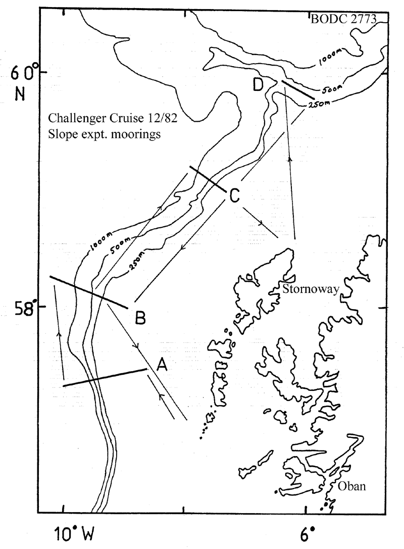
(1) To deploy current meter, pressure gauge and thermistor chain moorings along four sections across the Scottish Continental Slope between 57N and 59N. Acomplished with the exception of one mooring. (2) To work CTD profiles along these four sections. Accomplished, but salinity data are reported as noisy due to a faulty counter. (3) To measure bathymetric profiles along these sections. Accomplished. (4) To service SMBA moorings at M and the Tiree Passage and recover moorings from stations P and R. Not possible due to bad weather. (5) To collect large-volume samples for radiocaesium analysis on stations across the Scottish shelf from the Sound of Mull. Seven of ten stations sampled. |
| Ship | RRS Challenger |
| Departure Port | Ardrossan, United Kingdom |
| Departure Date | 1982-08-16 |
| Arrival Port | Barry, United Kingdom |
| Arrival Date | 1982-08-31 |
| Principal Scientist(s) | David Booth (Scottish Marine Biological Association) |
| Responsible Organisation | Scottish Marine Biological Association |
| Associated Project(s) | CONSLEX (Continental Slope Experiment) |
| IHB Sea Areas Visited | North East Atlantic Ocean (limit 40W) |
| Marsden Squares Visited | 181;476/181;478/181;479/182;372 |
| Work Area Description | N. & W. of Scotland |
| Unable to lookup cruise bounds at this time | |
| Work Area Bounding Polygon | |
| Southern Limit | unknown |
| Northern Limit | unknown |
| Western Limit | unknown |
| Eastern Limit | unknown |
Cruise Inventory Datasets
| Physical oceanography | |
|---|---|
| CTD stations |
Quantity:
number of stations =
18
Description: much of the salinity data is noisy due to a faulty counter. |
| Current meters |
Quantity:
number of stations =
16
Description: 38 c.m. laid;228 days |
| Sea level (inc. bot. press., inverted echosounder) | Description: 7 pressure gauges laid;1 recovered |
| Subsurface temperature measurements |
Quantity:
number of stations =
2
Description: |
| Chemical oceanography | |
| Radioactivity |
Quantity:
number of stations =
7
Description: water samples collected for radio-caesium analysis. |
Cruise Inventory Mooring/Buoy Operations
No information on datasets is currently available
Summary of BODC Data Holdings for the Cruise
National Oceanographic Database
Summary
| # Series | Instrument Description | Parameters |
|---|---|---|
| 18 | CTD/STD cast |
Salinity of the water column Temperature of the water column Vertical spatial coordinates |
Note: Parameter terms are taken from the BODC Parameter Discovery Vocabulary XML (SKOS)
Full List
| BODC Reference | Instrument Description | Date/Time | Location | |
|---|---|---|---|---|
| 186560 | CTD/STD cast | 1982-08-20 00:45Z | 57° 24' N, 8° 31' W | Click for more |
| 186572 | CTD/STD cast | 1982-08-21 14:22Z | 57° 21' N, 9° 5' W | Click for more |
| 186584 | CTD/STD cast | 1982-08-21 16:47Z | 57° 19' N, 9° 19' W | Click for more |
| 186596 | CTD/STD cast | 1982-08-21 21:02Z | 57° 19' N, 9° 28' W | Click for more |
| 186603 | CTD/STD cast | 1982-08-22 02:35Z | 57° 19' N, 9° 36' W | Click for more |
| 186615 | CTD/STD cast | 1982-08-22 04:17Z | 57° 19' N, 9° 43' W | Click for more |
| 186627 | CTD/STD cast | 1982-08-22 13:47Z | 57° 19' N, 9° 53' W | Click for more |
| 186639 | CTD/STD cast | 1982-08-22 23:40Z | 58° 11' N, 9° 57' W | Click for more |
| 186640 | CTD/STD cast | 1982-08-23 03:33Z | 58° 7' N, 9° 42' W | Click for more |
| 186652 | CTD/STD cast | 1982-08-23 07:06Z | 58° 6' N, 9° 33' W | Click for more |
| 186664 | CTD/STD cast | 1982-08-23 18:37Z | 59° 11' N, 7° 41' W | Click for more |
| 186676 | CTD/STD cast | 1982-08-23 20:18Z | 59° 9' N, 7° 39' W | Click for more |
| 186688 | CTD/STD cast | 1982-08-23 23:57Z | 59° 4' N, 7° 30' W | Click for more |
| 186707 | CTD/STD cast | 1982-08-24 03:15Z | 59° 0' N, 7° 23' W | Click for more |
| 186719 | CTD/STD cast | 1982-08-27 10:13Z | 59° 46' N, 6° 10' W | Click for more |
| 186720 | CTD/STD cast | 1982-08-27 13:38Z | 59° 39' N, 6° 1' W | Click for more |
| 186732 | CTD/STD cast | 1982-08-28 08:18Z | 57° 57' N, 8° 49' W | Click for more |
| 186744 | CTD/STD cast | 1982-08-28 14:02Z | 58° 0' N, 9° 9' W | Click for more |
Project Database
No data currently held for this cruise in the BODC Project Database
