BODC Cruise Metadata Report for RRS Discovery (74E3) cruise D130B
Introduction
This report collates information from the BODC cruise inventory and oceanographic databases. It presents
- Cruise Inventory Information
- A summary of BODC data holdings for the cruise from the
- References - including cruise tracks and cruise reports
Cruise Inventory Information
| Long name | RRS Discovery (74E3) cruise D130B |
|---|---|
| Short name | D130B |
| Objectives and Narrative |
Second leg of a 2-leg cruise with the following objectives:
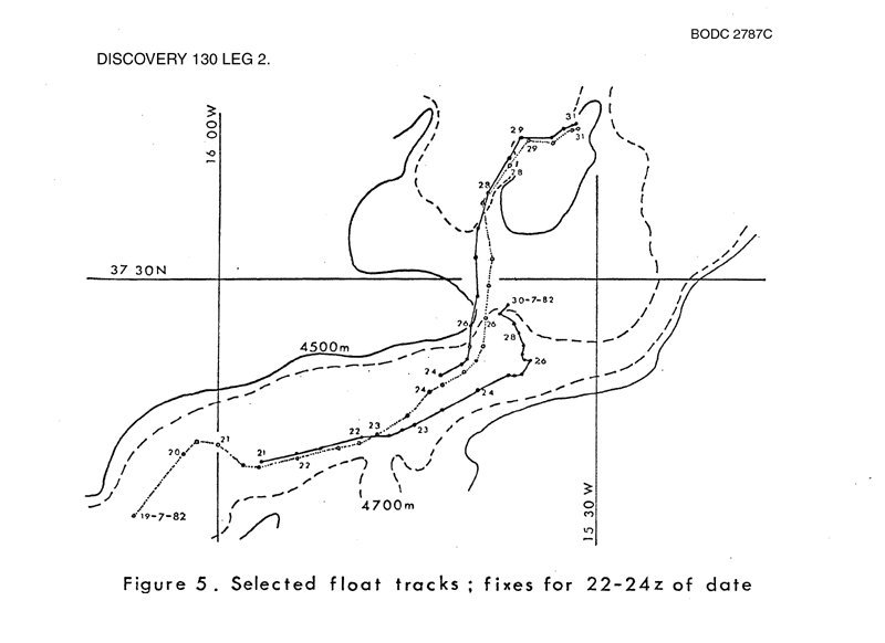
(1) To conduct sound ranging trials in the eastern Atlantic from 30-45 N to assess feasibility of long-range detection of neutrally-buoyant floats. (2) Investigate abyssal water exchange between Madeira and Iberian basins by studying flow through the 'Discovery Gap'. The work undertaken on this leg was: (1) Servicing the sound source mooring deployed on leg 1 and its retrieval at the end of the sound ranging experiment. (2)Working a series of hydrophone and CTD profiles at varying distance from the sound source mooring. (3) Release and tracking of neutrally buoyant floats in the Discovery Gap. (4) CTD survey in the Discovery Gap, including yo-yo time series. |
| Ship | RRS Discovery |
| Departure Port | Funchal, Portugal |
| Departure Date | 1982-07-10 |
| Arrival Port | Gibraltar, Gibraltar |
| Arrival Date | 1982-08-05 |
| Principal Scientist(s) | Peter M Saunders (Institute of Oceanographic Sciences Wormley Laboratory) |
| Responsible Organisation | Institute of Oceanographic Sciences Wormley Laboratory |
| Associated Project(s) | |
| IHB Sea Areas Visited | North East Atlantic Ocean (limit 40W) |
| Marsden Squares Visited | 110/111;1/111;3/146;1/146;2/146;3 |
| Work Area Description | Madeira Abyssal Plain |
| Unable to lookup cruise bounds at this time | |
| Work Area Bounding Polygon | |
| Southern Limit | unknown |
| Northern Limit | unknown |
| Western Limit | unknown |
| Eastern Limit | unknown |
Cruise Inventory Datasets
| Physical oceanography | |
|---|---|
| CTD stations |
Quantity:
number of stations =
22
Description: |
| Current meters | Description: 7 c.m.deployed;1 c.m.recovered;15 days |
| Neutrally buoyant floats |
Quantity:
number of deployments =
13
Description: |
| Meteorology | |
| Routine standard measurements | Description: |
| Geology and geophysics | |
| Multi-beam echosounding |
Quantity:
track kilometres =
370
Description: |
Cruise Inventory Mooring/Buoy Operations
No information on datasets is currently available
Summary of BODC Data Holdings for the Cruise
National Oceanographic Database
Summary
| # Series | Instrument Description | Parameters |
|---|---|---|
| 1 | CTD/STD cast |
Salinity of the water column Temperature of the water column Transmittance and attenuance of the water column Vertical spatial coordinates |
| 21 | CTD/STD cast |
Dissolved oxygen parameters in the water column Salinity of the water column Temperature of the water column Transmittance and attenuance of the water column Vertical spatial coordinates |
Note: Parameter terms are taken from the BODC Parameter Discovery Vocabulary XML (SKOS)
Full List
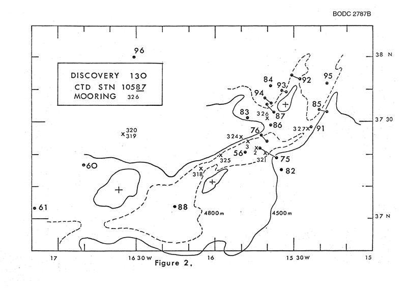
| BODC Reference | Instrument Description | Date/Time | Location | |
|---|---|---|---|---|
| 56317 | CTD/STD cast | 1982-07-13 05:40Z | 38° 19' N, 16° 0' W | Click for more |
| 56329 | CTD/STD cast | 1982-07-14 07:06Z | 40° 50' N, 15° 30' W | Click for more |
| 56330 | CTD/STD cast | 1982-07-15 16:09Z | 44° 19' N, 13° 43' W | Click for more |
| 56342 | CTD/STD cast | 1982-07-16 10:41Z | 46° 20' N, 13° 57' W | Click for more |
| 56354 | CTD/STD cast | 1982-07-19 21:48Z | 37° 19' N, 15° 39' W | Click for more |
| 56366 | CTD/STD cast | 1982-07-21 21:00Z | 37° 15' N, 15° 34' W | Click for more |
| 56378 | CTD/STD cast | 1982-07-22 07:32Z | 37° 31' N, 15° 47' W | Click for more |
| 56391 | CTD/STD cast | 1982-07-20 12:18Z | 37° 26' N, 15° 42' W | Click for more |
| 56409 | CTD/STD cast | 1982-07-26 05:52Z | 37° 29' N, 15° 37' W | Click for more |
| 56410 | CTD/STD cast | 1982-07-28 03:46Z | 37° 3' N, 16° 15' W | Click for more |
| 56422 | CTD/STD cast | 1982-07-24 04:20Z | 37° 40' N, 15° 37' W | Click for more |
| 56434 | CTD/STD cast | 1982-07-25 05:56Z | 37° 34' N, 15° 21' W | Click for more |
| 56446 | CTD/STD cast | 1982-07-28 19:20Z | 37° 28' N, 15° 24' W | Click for more |
| 56458 | CTD/STD cast | 1982-08-01 09:57Z | 37° 42' N, 15° 18' W | Click for more |
| 56471 | CTD/STD cast | 1982-08-01 20:32Z | 37° 49' N, 16° 30' W | Click for more |
| 56483 | CTD/STD cast | 1982-07-26 17:10Z | 37° 35' N, 15° 39' W | Click for more |
| 56495 | CTD/STD cast | 1982-08-02 16:48Z | 38° 39' N, 15° 15' W | Click for more |
| 56514 | CTD/STD cast | 1982-08-02 22:19Z | 37° 55' N, 14° 45' W | Click for more |
| 56526 | CTD/STD cast | 1982-07-29 23:00Z | 37° 43' N, 15° 28' W | Click for more |
| 56538 | CTD/STD cast | 1982-07-30 15:34Z | 37° 39' N, 15° 33' W | Click for more |
| 56551 | CTD/STD cast | 1982-07-31 21:09Z | 37° 36' N, 15° 38' W | Click for more |
| 88473 | CTD/STD cast | 1982-08-02 11:56Z | 38° 4' N, 15° 10' W | Click for more |
Project Database
No data currently held for this cruise in the BODC Project Database
