BODC Cruise Metadata Report for RV Cirolana (74CZ) cruise CIR7/83
Introduction
This report collates information from the BODC cruise inventory and oceanographic databases. It presents
- Cruise Inventory Information
- A summary of BODC data holdings for the cruise from the
- References - including cruise tracks and cruise reports
Cruise Inventory Information
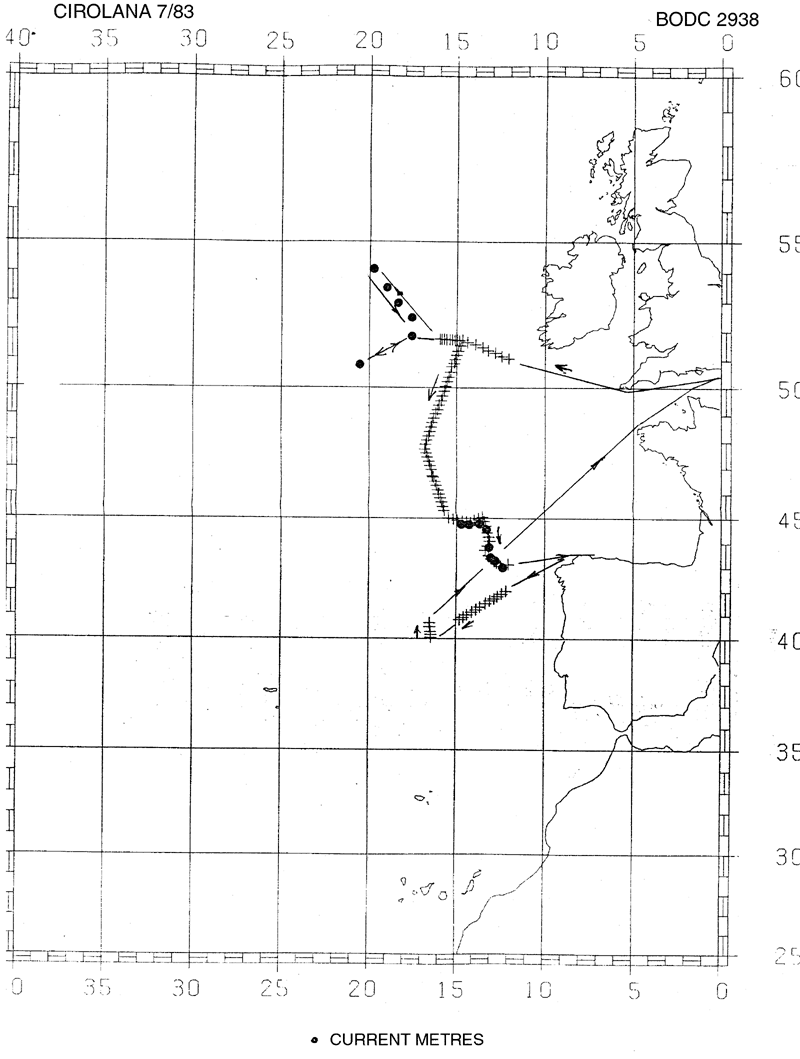
| Long name | RV Cirolana (74CZ) cruise CIR7/83 |
|---|---|
| Short name | CIR7/83 |
| Objectives and Narrative |
The objectives of this cruise were:
(1) To recover the Rockall Bank array of five current meter moorings plus a mooring between the tail of Rockall bank and the mid-Atlantic Ridge. Accomplished. (2) To re-lay the NEADS 6 mooring and an E-W line of 9 moorings along approximately 43-45N between the Iberia and Porcupine Basins. NEADS 6 plus 8 moorings deployed. (3) To deploy a short-term thermistor chain mooring at the slope erosion zone on Porcupine Bank. Accomplished (4) To work three full-depth 14C, 226/228Ra stations with nutrients and CTD on the meridional radiochemistry section, including one in the Discovery Gap. Five stations on transect worked, but Discovery gap not reached due to La Coruna port call for winch repairs. (5) To work up to six coring stations. Three good gravity cores obtained plus two partial Kaston cores. (6) To listen for COB and IOS SOFAR floats. Accomplished. (7) To work XBT sections in regions of interest, including the proposed MAFF SOFAR float launch site in the Iberian Abyssal Plain. XBTs deployed along passage sections, but Iberia Abyssal Plain survey not possible. (8) To recover and re-lay the colonisation experiment at the NEA dumpsite. Accomplished, but previous deployment compromised as drum failed to reach the bottom. (9) To deploy and recover fish traps. Four deployments returning one Coryphanoides, abundant large amphipods, a few deep euphausids, a small unidentified abyssal fish and apparent postlarva. (10) To test satellite-linked search and rescue buoys. Started but abandoned when the beacon sustained damage. |
| Ship | RV Cirolana |
| Departure Port | Grimsby, United Kingdom |
| Departure Date | 1983-06-29 |
| Arrival Port | Grimsby, United Kingdom |
| Arrival Date | 1983-07-28 |
| Principal Scientist(s) | Robert R Dickson (Ministry of Agriculture, Fisheries and Food Lowestoft Fisheries Laboratory) |
| Responsible Organisation | Ministry of Agriculture, Fisheries and Food Lowestoft Fisheries Laboratory |
| Associated Project(s) | |
| IHB Sea Areas Visited | North East Atlantic Ocean (limit 40W) |
| Marsden Squares Visited | 146;1/146;4/182;1/182;2/183;1 |
| Work Area Description | N.E. Atlantic, mid Atlantic Ridge, tail of Rockall Bank |
| Unable to lookup cruise bounds at this time | |
| Work Area Bounding Polygon | |
| Southern Limit | unknown |
| Northern Limit | unknown |
| Western Limit | unknown |
| Eastern Limit | unknown |
Cruise Inventory Datasets
| Physical oceanography | |
|---|---|
| Bathythermograph |
Quantity:
number of profiles =
96
Description: |
| CTD stations |
Quantity:
number of profiles =
3
Description: on two full-depth stations |
| Current meters |
Quantity:
number of recoveries =
15
Description: current meters recovered with 275 days of data recorded |
| Chemical oceanography | |
| Radioactivity |
Quantity:
number of samples =
7
Description: Surface caesium 137 (Cs-137) |
| Radioactivity |
Quantity:
number of samples =
9
Description: Gerard barrel samples for 14C |
| Biology and fisheries | |
| Other biological/fisheries measurement |
Quantity:
number of deployments =
4
Description: deep sea fish traps |
| Geology and geophysics | |
| Core - soft bottom |
Quantity:
number of cores =
5
Description: 3 good gravity cores plus 2 partial Kaston cores |
Cruise Inventory Mooring/Buoy Operations
No information on datasets is currently available
Summary of BODC Data Holdings for the Cruise
National Oceanographic Database
Summary
| # Series | Instrument Description | Parameters |
|---|---|---|
| 3 | CTD/STD cast |
Salinity of the water column Temperature of the water column Vertical spatial coordinates |
Note: Parameter terms are taken from the BODC Parameter Discovery Vocabulary XML (SKOS)
Full List
| BODC Reference | Instrument Description | Date/Time | Location | |
|---|---|---|---|---|
| 58312 | CTD/STD cast | 1983-07-08 09:52Z | 51° 41' N, 18° 13' W | Click for more |
| 58324 | CTD/STD cast | 1983-07-11 18:23Z | 47° 43' N, 16° 49' W | Click for more |
| 58336 | CTD/STD cast | 1983-07-23 21:21Z | 47° 46' N, 16° 50' W | Click for more |
Project Database
No data currently held for this cruise in the BODC Project Database
