BODC Cruise Metadata Report for RRS Discovery (74E3) cruise D138
Introduction
This report collates information from the BODC cruise inventory and oceanographic databases. It presents
- Cruise Inventory Information
- A summary of BODC data holdings for the cruise from the
- References - including cruise tracks and cruise reports
Cruise Inventory Information
| Long name | RRS Discovery (74E3) cruise D138 |
|---|---|
| Short name | D138 |
| Objectives and Narrative |
The objectives of this cruise were to:
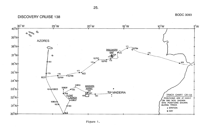
(1) To recover moorings set in the Discovery Gap in July 1982. (2) To carry out CTD and bathymetry surveys in the Discovery gap area. (3) To deploy three autonomous listening stations and undertake a CTD survey in the vicinity of the moorings. (4) To deploy and track neutrally-buoyant SOFAR floats. (5) To deploy a moored current meter array west of Madeira. (6) To occupy CTD stations within the Madeira current meter array. All objectives were accomplished. |
| Ship | RRS Discovery |
| Departure Port | Gibraltar, Gibraltar |
| Departure Date | 1983-06-17 |
| Arrival Port | Funchal, Portugal |
| Arrival Date | 1983-07-09 |
| Principal Scientist(s) | W John Gould (Institute of Oceanographic Sciences Wormley Laboratory) |
| Responsible Organisation | Institute of Oceanographic Sciences Wormley Laboratory |
| Associated Project(s) | |
| IHB Sea Areas Visited | North East Atlantic Ocean (limit 40W), Strait of Gibraltar (Mediterranean Sea) |
| Marsden Squares Visited | 109;1/109;2/109;3/109;4/110;1/110;2/110;373/110;4/111;1/111;235/111;246/111;351/111;4 |
| Work Area Description | N.E. Atlantic |
| Unable to lookup cruise bounds at this time | |
| Work Area Bounding Polygon | |
| Southern Limit | unknown |
| Northern Limit | unknown |
| Western Limit | unknown |
| Eastern Limit | unknown |
Cruise Inventory Datasets
| Physical oceanography | |
|---|---|
| CTD stations |
Quantity:
number of stations =
26
Description: CTD only |
| Current meters |
Quantity:
number of stations =
16
Description: 10 moorings deployed, 6 recoverd;1 year |
| Currents measured from ship drift | Description: |
| Neutrally buoyant floats |
Quantity:
number of deployments =
2
Description: |
| Other physical oceanographic measurements |
Quantity:
number of samples =
1
Description: moorings carrying concrete samples for building research establishment |
| Other physical oceanographic measurements |
Quantity:
number of deployments =
3
Description: autonomous listening stations |
| Subsurface temperature and salinity measurements | Description: T only |
| Surface measurements underway (T,S) | Description: hull mounted thermistor giving continuous readings T only |
| Water bottle stations | Description: calibration water bottles for CTD surface only |
| Meteorology | |
| Routine standard measurements | Description: synoptic hours |
| Geology and geophysics | |
| Multi-beam echosounding | Description: continuous |
Cruise Inventory Mooring/Buoy Operations
No information on datasets is currently available
Summary of BODC Data Holdings for the Cruise
National Oceanographic Database
Summary
| # Series | Instrument Description | Parameters |
|---|---|---|
| 2 | CTD/STD cast |
Salinity of the water column Temperature of the water column Vertical spatial coordinates |
| 22 | CTD/STD cast |
Dissolved oxygen parameters in the water column Salinity of the water column Temperature of the water column Transmittance and attenuance of the water column Vertical spatial coordinates |
Note: Parameter terms are taken from the BODC Parameter Discovery Vocabulary XML (SKOS)
Full List
| BODC Reference | Instrument Description | Date/Time | Location | |
|---|---|---|---|---|
| 58902 | CTD/STD cast | 1983-06-19 16:30Z | 37° 38' N, 13° 48' W | Click for more |
| 58914 | CTD/STD cast | 1983-06-20 22:49Z | 37° 20' N, 15° 49' W | Click for more |
| 58926 | CTD/STD cast | 1983-06-21 17:02Z | 37° 9' N, 16° 42' W | Click for more |
| 58938 | CTD/STD cast | 1983-06-21 22:44Z | 36° 51' N, 16° 40' W | Click for more |
| 58951 | CTD/STD cast | 1983-06-22 04:02Z | 36° 57' N, 16° 40' W | Click for more |
| 58963 | CTD/STD cast | 1983-06-22 12:25Z | 37° 4' N, 16° 42' W | Click for more |
| 58975 | CTD/STD cast | 1983-06-22 19:42Z | 36° 45' N, 16° 37' W | Click for more |
| 59002 | CTD/STD cast | 1983-07-01 10:02Z | 30° 0' N, 23° 30' W | Click for more |
| 59014 | CTD/STD cast | 1983-07-02 11:52Z | 31° 40' N, 22° 34' W | Click for more |
| 59026 | CTD/STD cast | 1983-07-03 07:07Z | 33° 0' N, 23° 30' W | Click for more |
| 59038 | CTD/STD cast | 1983-07-04 07:52Z | 33° 19' N, 21° 49' W | Click for more |
| 59051 | CTD/STD cast | 1983-06-30 19:02Z | 31° 30' N, 24° 22' W | Click for more |
| 59075 | CTD/STD cast | 1983-06-24 08:39Z | 36° 30' N, 17° 26' W | Click for more |
| 59087 | CTD/STD cast | 1983-06-24 18:22Z | 36° 30' N, 18° 31' W | Click for more |
| 59099 | CTD/STD cast | 1983-06-25 22:59Z | 34° 59' N, 21° 19' W | Click for more |
| 59106 | CTD/STD cast | 1983-06-26 12:08Z | 34° 37' N, 23° 1' W | Click for more |
| 59118 | CTD/STD cast | 1983-06-26 23:02Z | 34° 40' N, 24° 19' W | Click for more |
| 59131 | CTD/STD cast | 1983-06-24 02:16Z | 36° 36' N, 16° 49' W | Click for more |
| 59143 | CTD/STD cast | 1983-07-05 19:37Z | 32° 36' N, 20° 6' W | Click for more |
| 59155 | CTD/STD cast | 1983-07-07 06:25Z | 32° 27' N, 20° 8' W | Click for more |
| 59167 | CTD/STD cast | 1983-07-07 13:12Z | 32° 21' N, 20° 11' W | Click for more |
| 59179 | CTD/STD cast | 1983-07-07 20:23Z | 32° 16' N, 20° 14' W | Click for more |
| 59180 | CTD/STD cast | 1983-07-08 01:45Z | 32° 22' N, 20° 21' W | Click for more |
| 59192 | CTD/STD cast | 1983-07-08 09:25Z | 32° 21' N, 20° 15' W | Click for more |
Project Database
No data currently held for this cruise in the BODC Project Database
