BODC Cruise Metadata Report for RV Cirolana (74CZ) cruise CIR8/84
Introduction
This report collates information from the BODC cruise inventory and oceanographic databases. It presents
- Cruise Inventory Information
- A summary of BODC data holdings for the cruise from the
- References - including cruise tracks and cruise reports
Cruise Inventory Information
| Long name | RV Cirolana (74CZ) cruise CIR8/84 |
|---|---|
| Short name | CIR8/84 |
| Objectives and Narrative |
The objectives of this cruise were:
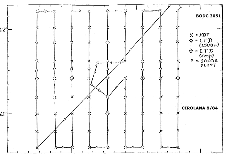
(1) To launch 6 SOFAR floats ballasted for 2500m. Five launches, one of which sank to the bottom. (2) To complete an XBT and CTD survey of the float launch area. Accomplished. (3) To collect water for 14C analysis. Insufficient time. (4) To collect surface water for 137Cs analysis. Accomplished |
| Ship | RV Cirolana |
| Departure Port | Grimsby, United Kingdom |
| Departure Date | 1984-09-25 |
| Arrival Port | Grimsby, United Kingdom |
| Arrival Date | 1984-10-11 |
| Principal Scientist(s) | Paul A Gurbutt (Ministry of Agriculture, Fisheries and Food Lowestoft Fisheries Laboratory) |
| Responsible Organisation | Ministry of Agriculture, Fisheries and Food Lowestoft Fisheries Laboratory |
| Associated Project(s) | |
| IHB Sea Areas Visited | North East Atlantic Ocean (limit 40W) |
| Marsden Squares Visited | 146 |
| Work Area Description | Iberian Abyssal Plain |
| Unable to lookup cruise bounds at this time | |
| Work Area Bounding Polygon | |
| Southern Limit | unknown |
| Northern Limit | unknown |
| Western Limit | unknown |
| Eastern Limit | unknown |
Cruise Inventory Datasets
| Physical oceanography | |
|---|---|
| Bathythermograph |
Quantity:
number of profiles =
74
Description: |
| CTD stations |
Quantity:
number of stations =
11
Description: 3 with T only |
| Neutrally buoyant floats |
Quantity:
number of deployments =
5
Description: SOFAR floats launched, but one sank to the bottom |
| Chemical oceanography | |
| Radioactivity |
Quantity:
number of samples =
7
Description: |
Cruise Inventory Mooring/Buoy Operations
No information on datasets is currently available
Summary of BODC Data Holdings for the Cruise
National Oceanographic Database
Summary
| # Series | Instrument Description | Parameters |
|---|---|---|
| 9 | CTD/STD cast |
Salinity of the water column Temperature of the water column Vertical spatial coordinates |
Note: Parameter terms are taken from the BODC Parameter Discovery Vocabulary XML (SKOS)
Full List
| BODC Reference | Instrument Description | Date/Time | Location | |
|---|---|---|---|---|
| 58348 | CTD/STD cast | 1984-09-30 02:00Z | 41° 25' N, 15° 33' W | Click for more |
| 58361 | CTD/STD cast | 1984-09-30 22:49Z | 41° 25' N, 14° 58' W | Click for more |
| 58373 | CTD/STD cast | 1984-10-01 17:42Z | 40° 34' N, 14° 25' W | Click for more |
| 58385 | CTD/STD cast | 1984-10-02 00:03Z | 41° 0' N, 14° 27' W | Click for more |
| 58397 | CTD/STD cast | 1984-10-02 08:00Z | 41° 25' N, 14° 27' W | Click for more |
| 58404 | CTD/STD cast | 1984-10-02 15:59Z | 41° 49' N, 14° 27' W | Click for more |
| 58416 | CTD/STD cast | 1984-10-03 00:25Z | 42° 16' N, 14° 27' W | Click for more |
| 58428 | CTD/STD cast | 1984-10-05 23:36Z | 41° 25' N, 13° 55' W | Click for more |
| 58441 | CTD/STD cast | 1984-10-06 20:46Z | 41° 25' N, 13° 21' W | Click for more |
Project Database
No data currently held for this cruise in the BODC Project Database
