BODC Cruise Metadata Report for RRS Discovery (74E3) cruise D146
Introduction
This report collates information from the BODC cruise inventory and oceanographic databases. It presents
- Cruise Inventory Information
- A summary of BODC data holdings for the cruise from the
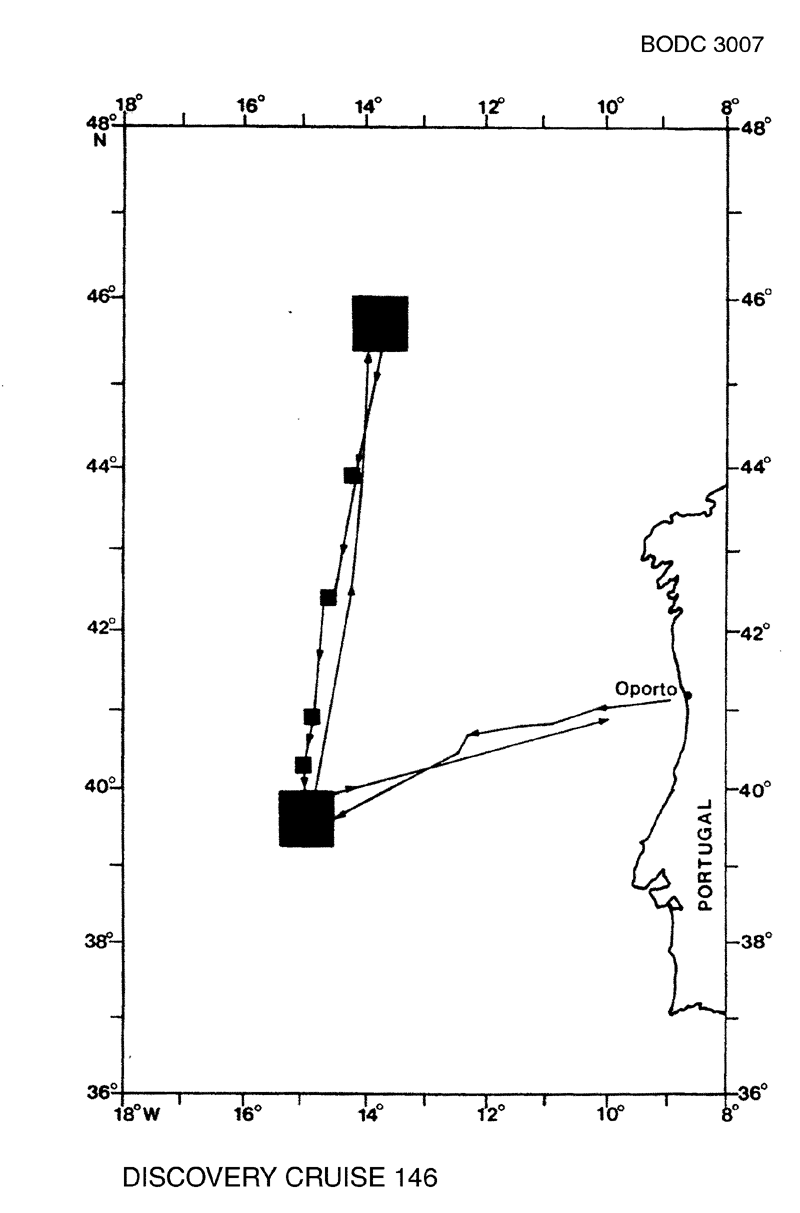
- References - including cruise tracks and cruise reports
Cruise Inventory Information
| Long name | RRS Discovery (74E3) cruise D146 |
|---|---|
| Short name | D146 |
| Objectives and Narrative |
The cruise had an interdisciplinary physical and biological programme. The physical element of the programme was designed to investigate the phenomena associated with the seasonal change over from winter cooling to summer heating of the surface waters of the ocean, and hence the seasonal development of thermal stratification within the surface layers of the water column. It consisted of a continuation of the studies begun during Cruise 145, and described in full detail in its Cruise Report. It centred around the deployment of two sets of current moorings in the vicinity of 40N 15W and 46N 14W. Each set of moorings included a subsurface current meter string, a toroid buoy with thermistor chains and meteorological instruments, and a free-drifting spar buoy carrying nine current meters. Repeated SeaSoar surveys were run around the spar buoy.
The biological element of the programme was designed to capitalise on the substantial quantity of physical background information available for the two main localities, and to describe the changes in the structure and vertical distributions of the pelagic communities associated with the physical changes. Using the fluorometer fitted in SeaSoar the spatial distribution of chlorophyll was examined in relation to the physical structure of the water. The fluorometer observations were related to the vertical distribution of particulates, light attenuation and nutrients as well as temperature and salinity by the use of shallow CTD profiling and water sampling. A number of productivity observations were made mostly using water samples collected in the chlorophyll maximum. Series of midwater trawls were taken with the RMT1 +8M system in order to try to relate the vertical distributions of plankton and micronekton at the two main stations with the physical regime. Oblique trawls down to 1000m were made at intervals between the main stations to examine the gross community changes which occurred from north to south in this region which is the transition one between where thermal stratification is permanent and where it occurs only seasonally. |
| Ship | RRS Discovery |
| Departure Port | Oporto, Portugal |
| Departure Date | 1984-03-27 |
| Arrival Port | Oporto, Portugal |
| Arrival Date | 1984-04-24 |
| Principal Scientist(s) | Martin V Angel (Institute of Oceanographic Sciences Wormley Laboratory) |
| Responsible Organisation | Institute of Oceanographic Sciences Wormley Laboratory |
| Associated Project(s) | |
| IHB Sea Areas Visited | North East Atlantic Ocean (limit 40W) |
| Marsden Squares Visited | 110;394/110;495/146;104/146;124/146;134/146;353/146;354 |
| Work Area Description | E. Atlantic |
| Unable to lookup cruise bounds at this time | |
| Work Area Bounding Polygon | |
| Southern Limit | unknown |
| Northern Limit | unknown |
| Western Limit | unknown |
| Eastern Limit | unknown |
Cruise Inventory Datasets
| Physical oceanography | |
|---|---|
| CTD stations |
Quantity:
number of stations =
31
Description: on disc |
| Current meters | Description: 5 c.m.deployed;5 c.m.recovered;3x5/2x35 days |
| Optics (eg underwater light levels) |
Quantity:
13
Description: light profile;on disc |
| Subsurface temperature and salinity measurements |
Quantity:
track kilometres =
2722
Description: on disc |
| Surface measurements underway (T,S) |
Quantity:
track kilometres =
4630
Description: on disc |
| Transparency (eg transmissometer) |
Quantity:
31
Description: on disc |
| Water bottle stations |
Quantity:
number of stations =
27
Description: |
| Chemical oceanography | |
| Nitrate |
Quantity:
281
Description: |
| Oxygen |
Quantity:
4
Description: |
| Phosphate |
Quantity:
281
Description: |
| Silicate |
Quantity:
281
Description: |
| Biology and fisheries | |
| Nekton |
Quantity:
184
Description: |
| Pelagic fish |
Quantity:
number of hauls =
92
Description: survey:taxonomy,distribution,biomass determination |
| Phytoplankton pigs (eg chlorophyll, fluorescence) |
Quantity:
5
Description: |
| Primary productivity |
Quantity:
4
Description: |
| Seston |
Quantity:
11
Description: on disc |
| Zooplankton |
Quantity:
92
Description: |
| Meteorology | |
| Routine standard measurements | Description: |
Cruise Inventory Mooring/Buoy Operations
No information on datasets is currently available
Summary of BODC Data Holdings for the Cruise
National Oceanographic Database
Summary
| # Series | Instrument Description | Parameters |
|---|---|---|
| 6 | CTD/STD cast |
Dissolved oxygen parameters in the water column Salinity of the water column Temperature of the water column Vertical spatial coordinates |
| 11 | CTD/STD cast |
Dissolved oxygen parameters in the water column Salinity of the water column Temperature of the water column Transmittance and attenuance of the water column Vertical spatial coordinates Visible waveband radiance and irradiance measurements in the water column |
| 13 | CTD/STD cast |
Dissolved oxygen parameters in the water column Salinity of the water column Temperature of the water column Transmittance and attenuance of the water column Vertical spatial coordinates |
Note: Parameter terms are taken from the BODC Parameter Discovery Vocabulary XML (SKOS)
Full List
| BODC Reference | Instrument Description | Date/Time | Location | |
|---|---|---|---|---|
| 437011 | CTD/STD cast | 1984-03-31 10:40Z | 39° 33' N, 14° 37' W | Click for more |
| 437023 | CTD/STD cast | 1984-03-31 15:32Z | 39° 30' N, 14° 53' W | Click for more |
| 437035 | CTD/STD cast | 1984-03-31 19:47Z | 39° 46' N, 14° 54' W | Click for more |
| 437047 | CTD/STD cast | 1984-04-01 00:32Z | 39° 33' N, 15° 10' W | Click for more |
| 437059 | CTD/STD cast | 1984-04-01 03:42Z | 39° 34' N, 14° 51' W | Click for more |
| 437060 | CTD/STD cast | 1984-04-01 06:50Z | 39° 21' N, 14° 52' W | Click for more |
| 437072 | CTD/STD cast | 1984-04-01 20:20Z | 39° 35' N, 14° 49' W | Click for more |
| 437084 | CTD/STD cast | 1984-04-02 14:35Z | 39° 38' N, 14° 48' W | Click for more |
| 437096 | CTD/STD cast | 1984-04-02 19:21Z | 39° 37' N, 15° 1' W | Click for more |
| 437103 | CTD/STD cast | 1984-04-02 22:37Z | 39° 35' N, 14° 49' W | Click for more |
| 437115 | CTD/STD cast | 1984-04-03 08:52Z | 39° 36' N, 14° 51' W | Click for more |
| 437127 | CTD/STD cast | 1984-04-08 07:48Z | 45° 37' N, 13° 51' W | Click for more |
| 437139 | CTD/STD cast | 1984-04-11 07:06Z | 45° 40' N, 13° 50' W | Click for more |
| 437140 | CTD/STD cast | 1984-04-11 20:55Z | 45° 46' N, 13° 33' W | Click for more |
| 437152 | CTD/STD cast | 1984-04-11 23:34Z | 45° 54' N, 13° 36' W | Click for more |
| 437164 | CTD/STD cast | 1984-04-12 02:26Z | 45° 49' N, 13° 40' W | Click for more |
| 437176 | CTD/STD cast | 1984-04-13 08:52Z | 44° 1' N, 14° 9' W | Click for more |
| 437188 | CTD/STD cast | 1984-04-13 14:55Z | 43° 52' N, 14° 10' W | Click for more |
| 437207 | CTD/STD cast | 1984-04-14 01:45Z | 42° 30' N, 14° 30' W | Click for more |
| 437219 | CTD/STD cast | 1984-04-14 16:11Z | 40° 59' N, 14° 51' W | Click for more |
| 437220 | CTD/STD cast | 1984-04-15 14:44Z | 40° 15' N, 15° 0' W | Click for more |
| 437232 | CTD/STD cast | 1984-04-15 22:20Z | 39° 30' N, 14° 59' W | Click for more |
| 437244 | CTD/STD cast | 1984-04-16 04:33Z | 39° 38' N, 14° 48' W | Click for more |
| 437256 | CTD/STD cast | 1984-04-16 07:33Z | 39° 27' N, 14° 45' W | Click for more |
| 437268 | CTD/STD cast | 1984-04-18 07:32Z | 39° 34' N, 14° 58' W | Click for more |
| 437281 | CTD/STD cast | 1984-04-18 13:54Z | 39° 45' N, 14° 59' W | Click for more |
| 437293 | CTD/STD cast | 1984-04-18 19:31Z | 39° 36' N, 15° 1' W | Click for more |
| 437300 | CTD/STD cast | 1984-04-19 05:32Z | 39° 41' N, 15° 4' W | Click for more |
| 437312 | CTD/STD cast | 1984-04-20 02:31Z | 39° 40' N, 15° 4' W | Click for more |
| 437324 | CTD/STD cast | 1984-04-20 08:23Z | 39° 43' N, 15° 3' W | Click for more |
Project Database
No data currently held for this cruise in the BODC Project Database
