BODC Cruise Metadata Report for RRS Charles Darwin (74AB) cruise CD3
Introduction
This report collates information from the BODC cruise inventory and oceanographic databases. It presents
- Cruise Inventory Information
- A summary of BODC data holdings for the cruise from the
- References - including cruise tracks and cruise reports
Cruise Inventory Information
| Long name | RRS Charles Darwin (74AB) cruise CD3 |
|---|---|
| Short name | CD3 |
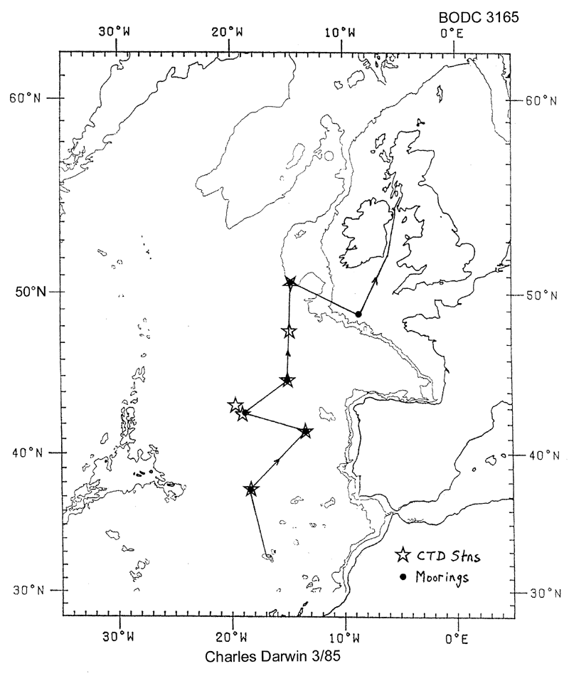
| Objectives and Narrative | Recovery and redeployment of NE Atlantic Autonomous Listening Stations. Recovery of current meters from the western slope of the Porcupine Bank and DB2 surface current mooring. Occupation of CTD stations along N/S NE Atlantic section from 37N to 50N. Test deployment and recovery of BERTHA benthic thermistor chain. |
| Ship | RRS Charles Darwin |
| Departure Port | Funchal, Portugal |
| Departure Date | 1985-04-28 |
| Arrival Port | Ardrossan, United Kingdom |
| Arrival Date | 1985-05-14 |
| Principal Scientist(s) | W John Gould (Institute of Oceanographic Sciences Wormley Laboratory) |
| Responsible Organisation | Institute of Oceanographic Sciences Wormley Laboratory |
| Associated Project(s) | |
| IHB Sea Areas Visited | North East Atlantic Ocean (limit 40W) |
| Marsden Squares Visited | 110/145;4/146/182;1 |
| Work Area Description | East Azores |
| Unable to lookup cruise bounds at this time | |
| Work Area Bounding Polygon | |
| Southern Limit | unknown |
| Northern Limit | unknown |
| Western Limit | unknown |
| Eastern Limit | unknown |
Cruise Inventory Datasets
| Physical oceanography | |
|---|---|
| CTD stations |
Quantity:
number of profiles =
16
Description: |
| Current meters |
Quantity:
number of recoveries =
17
Description: 245 days;recovered since Challenger cr. 6 1984. |
| Other physical oceanographic measurements |
Quantity:
number of recoveries =
5
Description: ALS,deployed for 230 days on Discovery cr. 151 in 1984. |
| Other physical oceanographic measurements |
Quantity:
number of recoveries =
1
Description: Near surface current meter mooring deployed on Charles Darwin cr.1/85 for 86 days |
| Subsurface temperature and salinity measurements |
Quantity:
number of deployments =
17
Description: 17 deep c.m. with temp.sensors. T only |
| Subsurface temperature measurements | Description: |
| Meteorology | |
| Routine standard measurements |
Quantity:
activity duration in days =
6
Description: |
Cruise Inventory Mooring/Buoy Operations
No information on datasets is currently available
Summary of BODC Data Holdings for the Cruise
National Oceanographic Database
Summary
| # Series | Instrument Description | Parameters |
|---|---|---|
| 6 | CTD/STD cast |
Salinity of the water column Temperature of the water column Transmittance and attenuance of the water column Vertical spatial coordinates |
| 1 | CTD/STD cast |
Dissolved oxygen parameters in the water column Salinity of the water column Temperature of the water column Transmittance and attenuance of the water column Vertical spatial coordinates |
Note: Parameter terms are taken from the BODC Parameter Discovery Vocabulary XML (SKOS)
Full List
| BODC Reference | Instrument Description | Date/Time | Location | |
|---|---|---|---|---|
| 57204 | CTD/STD cast | 1985-04-30 11:29Z | 37° 17' N, 18° 38' W | Click for more |
| 57216 | CTD/STD cast | 1985-05-02 21:39Z | 41° 29' N, 13° 28' W | Click for more |
| 57228 | CTD/STD cast | 1985-05-04 21:48Z | 42° 39' N, 20° 0' W | Click for more |
| 57241 | CTD/STD cast | 1985-05-05 05:25Z | 43° 7' N, 19° 49' W | Click for more |
| 57253 | CTD/STD cast | 1985-05-06 14:39Z | 44° 51' N, 14° 59' W | Click for more |
| 57265 | CTD/STD cast | 1985-05-07 10:40Z | 47° 44' N, 15° 21' W | Click for more |
| 57277 | CTD/STD cast | 1985-05-10 09:18Z | 50° 33' N, 14° 55' W | Click for more |
Project Database
No data currently held for this cruise in the BODC Project Database
