BODC Cruise Metadata Report for RV Clione cruise CLI4/85
Introduction
This report collates information from the BODC cruise inventory and oceanographic databases. It presents
- Cruise Inventory Information
- A summary of BODC data holdings for the cruise from the
- References - including cruise tracks and cruise reports
Cruise Inventory Information
| Long name | RV Clione cruise CLI4/85 |
|---|---|
| Short name | CLI4/85 |
| Objectives and Narrative |
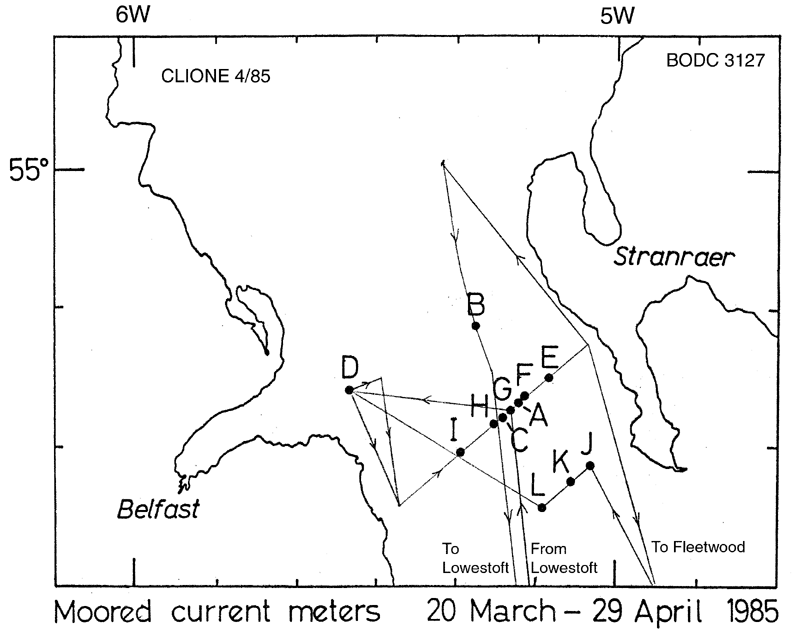
1. To recover a current meter station from the North Channel and lay an array of 12 current meter stations.
2. To lay and recover a current meter test rig to compare the performance of modified meters. No trace of the station to be recovered was found. 3. To make a CTD survey of the North Channel. 4. To take water samples for analysis of cadmium lead and copper on board. 5. To lay the near bed velocity meter off Southwold on the outward passage and recover on return. 6. To take water samples for caesium analysis on passage to the Irish Sea. |
| Ship | RV Clione |
| Departure Port | Lowestoft, United Kingdom |
| Departure Date | 1985-03-19 |
| Arrival Port | Lowestoft, United Kingdom |
| Arrival Date | 1985-04-02 |
| Principal Scientist(s) | J Alan Durance (Ministry of Agriculture, Fisheries and Food Lowestoft Fisheries Laboratory) |
| Responsible Organisation | Ministry of Agriculture, Fisheries and Food Lowestoft Fisheries Laboratory |
| Associated Project(s) | |
| IHB Sea Areas Visited | Bristol Channel, North East Atlantic Ocean (limit 40W) |
| Marsden Squares Visited | 181;245/181;455 |
| Work Area Description | North Channel/ Southwold |
| Unable to lookup cruise bounds at this time | |
| Work Area Bounding Polygon | |
| Southern Limit | unknown |
| Northern Limit | unknown |
| Western Limit | unknown |
| Eastern Limit | unknown |
Cruise Inventory Datasets
| Physical oceanography | |
|---|---|
| CTD stations |
Quantity:
number of stations =
15
Description: 2 with T only |
| Current meters | Description: 23 current meters deployed |
| Geochemical tracers (eg freons) |
Quantity:
number of samples =
45
Description: caesium samples (Cs) |
| Surface drifters/drifting buoys |
Quantity:
number of deployments =
548
Description: bottom |
| Chemical oceanography | |
| Nitrate |
Quantity:
number of stations =
14
Description: |
| Nitrite |
Quantity:
number of stations =
14
Description: |
| Oxygen |
Quantity:
number of stations =
14
Description: |
| Phosphate |
Quantity:
number of stations =
14
Description: |
| Silicate |
Quantity:
number of stations =
14
Description: |
| Contamination | |
| Trace metals |
Quantity:
number of samples =
32
Description: |
Cruise Inventory Mooring/Buoy Operations
No information on datasets is currently available
Summary of BODC Data Holdings for the Cruise
National Oceanographic Database
Summary
| # Series | Instrument Description | Parameters |
|---|---|---|
| 13 | CTD/STD cast |
Salinity of the water column Temperature of the water column Vertical spatial coordinates |
Note: Parameter terms are taken from the BODC Parameter Discovery Vocabulary XML (SKOS)
Full List
| BODC Reference | Instrument Description | Date/Time | Location | |
|---|---|---|---|---|
| 180263 | CTD/STD cast | 1985-03-24 09:52Z | 54° 43' N, 5° 33' W | Click for more |
| 180275 | CTD/STD cast | 1985-03-24 13:06Z | 54° 36' N, 5° 26' W | Click for more |
| 180287 | CTD/STD cast | 1985-03-24 14:37Z | 54° 37' N, 5° 23' W | Click for more |
| 180299 | CTD/STD cast | 1985-03-24 17:55Z | 54° 39' N, 5° 19' W | Click for more |
| 180306 | CTD/STD cast | 1985-03-25 06:32Z | 54° 41' N, 5° 15' W | Click for more |
| 180318 | CTD/STD cast | 1985-03-25 10:00Z | 54° 42' N, 5° 13' W | Click for more |
| 180331 | CTD/STD cast | 1985-03-25 12:35Z | 54° 42' N, 5° 12' W | Click for more |
| 180343 | CTD/STD cast | 1985-03-25 23:25Z | 54° 46' N, 5° 5' W | Click for more |
| 180355 | CTD/STD cast | 1985-03-29 06:33Z | 55° 1' N, 5° 22' W | Click for more |
| 180367 | CTD/STD cast | 1985-03-29 08:22Z | 54° 56' N, 5° 21' W | Click for more |
| 180379 | CTD/STD cast | 1985-03-29 10:01Z | 54° 52' N, 5° 19' W | Click for more |
| 180380 | CTD/STD cast | 1985-03-29 11:34Z | 54° 48' N, 5° 17' W | Click for more |
| 180392 | CTD/STD cast | 1985-03-29 15:02Z | 54° 45' N, 5° 15' W | Click for more |
Project Database
No data currently held for this cruise in the BODC Project Database
