BODC Cruise Metadata Report for RV Clione cruise CLI5B/85
Introduction
This report collates information from the BODC cruise inventory and oceanographic databases. It presents
- Cruise Inventory Information
- A summary of BODC data holdings for the cruise from the
- References - including cruise tracks and cruise reports
Cruise Inventory Information
| Long name | RV Clione cruise CLI5B/85 |
|---|---|
| Short name | CLI5B/85 |
| Objectives and Narrative |
The objectives of this cruise were:
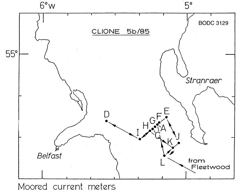
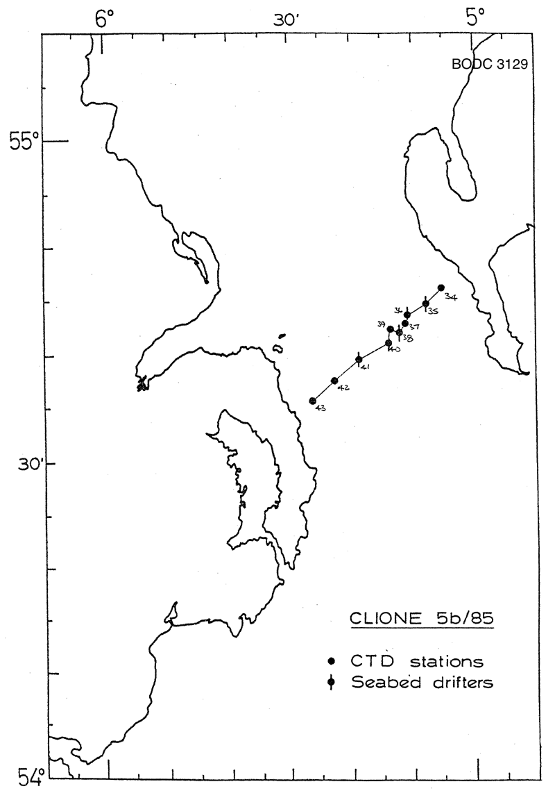
(1) To recover the 11 current meter moorings deployed in the North channel by RV Clione cruise 4/85. All moorings recovered with 2 (of 23) current meters lost. (2) To re-lay 6 of the 11 moorings. Accomplished. Nab Tower mooring also re-deployed. (3) To make a CTD survey of the North Channel with water samples fro nutrients. Section completed across the Channel. (4) To release se-bed drifters at each mooring site. Accomplished. (5) To take surface water samples from the North Channel and Irish Sea for radiocaesium analysis. Accomplished. |
| Ship | RV Clione |
| Departure Port | Fleetwood, United Kingdom |
| Departure Date | 1985-04-21 |
| Arrival Port | Lowestoft, United Kingdom |
| Arrival Date | 1985-04-29 |
| Principal Scientist(s) | J Alan Durance (Ministry of Agriculture, Fisheries and Food Lowestoft Fisheries Laboratory) |
| Responsible Organisation | Ministry of Agriculture, Fisheries and Food Lowestoft Fisheries Laboratory |
| Associated Project(s) | |
| IHB Sea Areas Visited | Irish Sea and St. George's Channel |
| Marsden Squares Visited | 181;245 |
| Work Area Description | North Channel |
| Unable to lookup cruise bounds at this time | |
| Work Area Bounding Polygon | |
| Southern Limit | unknown |
| Northern Limit | unknown |
| Western Limit | unknown |
| Eastern Limit | unknown |
Cruise Inventory Datasets
| Physical oceanography | |
|---|---|
| CTD stations |
Quantity:
number of stations =
10
Description: |
| Current meters | Description: 11 deployed,23 recoverd;30 days |
| Surface drifters/drifting buoys |
Quantity:
number of deployments =
302
Description: bottom |
| Chemical oceanography | |
| Nitrate |
Quantity:
number of stations =
10
Description: |
| Nitrite |
Quantity:
number of stations =
10
Description: |
| Phosphate |
Quantity:
number of stations =
10
Description: |
| Radioactivity |
Quantity:
number of samples =
31
Description: caesium (Cs) |
| Silicate |
Quantity:
number of stations =
10
Description: |
Cruise Inventory Mooring/Buoy Operations
No information on datasets is currently available
Summary of BODC Data Holdings for the Cruise
National Oceanographic Database
Summary
| # Series | Instrument Description | Parameters |
|---|---|---|
| 10 | CTD/STD cast |
Salinity of the water column Temperature of the water column Vertical spatial coordinates |
Note: Parameter terms are taken from the BODC Parameter Discovery Vocabulary XML (SKOS)
Full List
| BODC Reference | Instrument Description | Date/Time | Location | |
|---|---|---|---|---|
| 180146 | CTD/STD cast | 1985-04-25 08:40Z | 54° 46' N, 5° 6' W | Click for more |
| 180158 | CTD/STD cast | 1985-04-25 09:43Z | 54° 46' N, 5° 9' W | Click for more |
| 180171 | CTD/STD cast | 1985-04-25 11:40Z | 54° 43' N, 5° 11' W | Click for more |
| 180183 | CTD/STD cast | 1985-04-25 12:51Z | 54° 43' N, 5° 12' W | Click for more |
| 180195 | CTD/STD cast | 1985-04-25 14:05Z | 54° 42' N, 5° 12' W | Click for more |
| 180202 | CTD/STD cast | 1985-04-25 15:11Z | 54° 42' N, 5° 14' W | Click for more |
| 180214 | CTD/STD cast | 1985-04-25 16:41Z | 54° 41' N, 5° 14' W | Click for more |
| 180226 | CTD/STD cast | 1985-04-25 17:32Z | 54° 39' N, 5° 19' W | Click for more |
| 180238 | CTD/STD cast | 1985-04-25 18:20Z | 54° 37' N, 5° 22' W | Click for more |
| 180251 | CTD/STD cast | 1985-04-25 18:59Z | 54° 36' N, 5° 26' W | Click for more |
Project Database
No data currently held for this cruise in the BODC Project Database
