BODC Cruise Metadata Report for RV Clione cruise CLI7/85
Introduction
This report collates information from the BODC cruise inventory and oceanographic databases. It presents
- Cruise Inventory Information
- A summary of BODC data holdings for the cruise from the
- References - including cruise tracks and cruise reports
Cruise Inventory Information
| Long name | RV Clione cruise CLI7/85 |
|---|---|
| Short name | CLI7/85 |
| Objectives and Narrative |
The objectives of this cruise were:
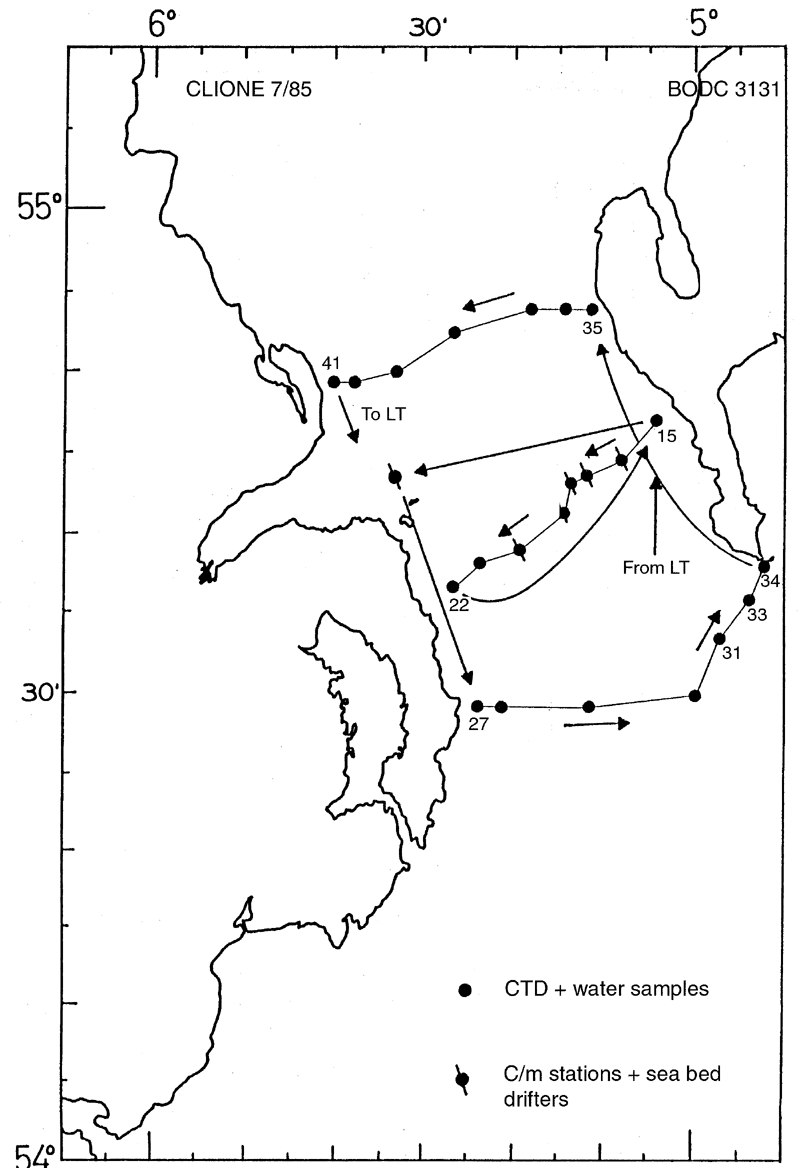
(1) To recover the 6 current meter moorings deployed by RV Clione cruise 5B. Four recovered intact plus another collected from a naval patrol vessel. (2) To recover the current meter mooring deployed at Nab Tower. Recovered intact. (3) To make a CTD survey of the North Channel with water samples for nutrients. Three sections worked. (4) To release sea-bed drifters at each North Channel current meter station. Accomplished. (5) To collect water samples for analysis of CD, Pb, Cu and Hg. Accomplished. (6) To take surface water samples from the North Channel and Irish Sea for radiocaesium analysis. Accomplished. |
| Ship | RV Clione |
| Departure Port | Lowestoft, United Kingdom |
| Departure Date | 1985-06-07 |
| Arrival Port | Lowestoft, United Kingdom |
| Arrival Date | 1985-06-17 |
| Principal Scientist(s) | J Alan Durance (Ministry of Agriculture, Fisheries and Food Lowestoft Fisheries Laboratory) |
| Responsible Organisation | Ministry of Agriculture, Fisheries and Food Lowestoft Fisheries Laboratory |
| Associated Project(s) | |
| IHB Sea Areas Visited | Irish Sea and St. George's Channel |
| Marsden Squares Visited | 181;144/181;245 |
| Work Area Description | North Channel; Irish Sea |
| Unable to lookup cruise bounds at this time | |
| Work Area Bounding Polygon | |
| Southern Limit | unknown |
| Northern Limit | unknown |
| Western Limit | unknown |
| Eastern Limit | unknown |
Cruise Inventory Datasets
| Physical oceanography | |
|---|---|
| CTD stations |
Quantity:
number of stations =
23
Description: |
| Current meters |
Quantity:
number of stations =
7
Description: 11 current meters recovered;45 days |
| Surface drifters/drifting buoys |
Quantity:
number of deployments =
300
Description: bottom |
| Chemical oceanography | |
| Nitrate |
Quantity:
number of stations =
22
Description: |
| Nitrite |
Quantity:
number of stations =
22
Description: |
| Oxygen | Description: |
| Phosphate |
Quantity:
number of stations =
22
Description: |
| Radioactivity |
Quantity:
number of samples =
30
Description: caesium (Cs) |
| Silicate |
Quantity:
number of stations =
22
Description: |
| Contamination | |
| Trace metals |
Quantity:
number of samples =
31
Description: |
Cruise Inventory Mooring/Buoy Operations
No information on datasets is currently available
Summary of BODC Data Holdings for the Cruise
National Oceanographic Database
Summary
| # Series | Instrument Description | Parameters |
|---|---|---|
| 22 | CTD/STD cast |
Salinity of the water column Temperature of the water column Vertical spatial coordinates |
Note: Parameter terms are taken from the BODC Parameter Discovery Vocabulary XML (SKOS)
Full List
| BODC Reference | Instrument Description | Date/Time | Location | |
|---|---|---|---|---|
| 179907 | CTD/STD cast | 1985-06-11 05:54Z | 54° 46' N, 5° 4' W | Click for more |
| 179919 | CTD/STD cast | 1985-06-11 07:44Z | 54° 44' N, 5° 7' W | Click for more |
| 179920 | CTD/STD cast | 1985-06-11 10:24Z | 54° 43' N, 5° 11' W | Click for more |
| 179932 | CTD/STD cast | 1985-06-11 13:08Z | 54° 42' N, 5° 12' W | Click for more |
| 179944 | CTD/STD cast | 1985-06-11 17:28Z | 54° 41' N, 5° 14' W | Click for more |
| 179956 | CTD/STD cast | 1985-06-11 18:39Z | 54° 39' N, 5° 19' W | Click for more |
| 179968 | CTD/STD cast | 1985-06-11 20:19Z | 54° 37' N, 5° 22' W | Click for more |
| 179981 | CTD/STD cast | 1985-06-11 21:09Z | 54° 36' N, 5° 26' W | Click for more |
| 179993 | CTD/STD cast | 1985-06-12 16:40Z | 54° 29' N, 5° 23' W | Click for more |
| 180005 | CTD/STD cast | 1985-06-12 17:19Z | 54° 29' N, 5° 21' W | Click for more |
| 180017 | CTD/STD cast | 1985-06-12 18:34Z | 54° 29' N, 5° 11' W | Click for more |
| 180029 | CTD/STD cast | 1985-06-12 19:41Z | 54° 30' N, 5° 0' W | Click for more |
| 180030 | CTD/STD cast | 1985-06-12 21:00Z | 54° 33' N, 4° 57' W | Click for more |
| 180042 | CTD/STD cast | 1985-06-13 05:25Z | 54° 36' N, 4° 54' W | Click for more |
| 180054 | CTD/STD cast | 1985-06-13 06:00Z | 54° 37' N, 4° 52' W | Click for more |
| 180066 | CTD/STD cast | 1985-06-13 08:36Z | 54° 54' N, 5° 11' W | Click for more |
| 180078 | CTD/STD cast | 1985-06-13 09:06Z | 54° 54' N, 5° 13' W | Click for more |
| 180091 | CTD/STD cast | 1985-06-13 10:00Z | 54° 52' N, 5° 18' W | Click for more |
| 180109 | CTD/STD cast | 1985-06-13 11:39Z | 54° 51' N, 5° 26' W | Click for more |
| 180110 | CTD/STD cast | 1985-06-13 12:35Z | 54° 50' N, 5° 33' W | Click for more |
| 180122 | CTD/STD cast | 1985-06-13 13:23Z | 54° 49' N, 5° 38' W | Click for more |
| 180134 | CTD/STD cast | 1985-06-13 14:05Z | 54° 49' N, 5° 40' W | Click for more |
Project Database
No data currently held for this cruise in the BODC Project Database
