BODC Cruise Metadata Report for RV Clione cruise CLI5A/86
Introduction
This report collates information from the BODC cruise inventory and oceanographic databases. It presents
- Cruise Inventory Information
- A summary of BODC data holdings for the cruise from the
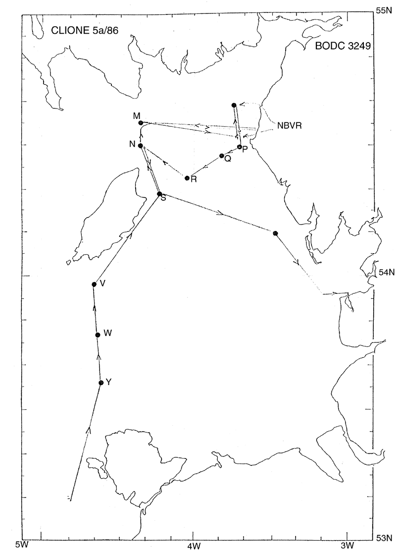
- References - including cruise tracks and cruise reports
Cruise Inventory Information
| Long name | RV Clione cruise CLI5A/86 |
|---|---|
| Short name | CLI5A/86 |
| Objectives and Narrative |
The objectives of this cruise were:
(1) To service six current meter moorings in the Eastern Irish Sea. Two serviced and four new stations established to replace moorings presumed destroyed. (2) To service the Near-bed Velocity recorder tetrapod mooring. Recovered but not re-deployed. (3) To work a 15-hour anchor station near the tetrapod collecting water samples for SPM particle size analysis and making DRCM and CTD measurements. Accomplished. (4) To work CTD sections between the Isle of Man and the Scottish and English coasts. No sections worked. (5) To collect surface water samples for radiocaesium analysis. Accomplished. |
| Ship | RV Clione |
| Departure Port | Lowestoft, United Kingdom |
| Departure Date | 1986-04-07 |
| Arrival Port | Fleetwood, United Kingdom |
| Arrival Date | 1986-04-14 |
| Principal Scientist(s) | J Alan Durance (Ministry of Agriculture, Fisheries and Food Lowestoft Fisheries Laboratory) |
| Responsible Organisation | Ministry of Agriculture, Fisheries and Food Lowestoft Fisheries Laboratory |
| Associated Project(s) | |
| IHB Sea Areas Visited | Irish Sea and St. George's Channel |
| Marsden Squares Visited | 181;134/181;143/181;144 |
| Work Area Description | Eastern Irish Sea |
| Unable to lookup cruise bounds at this time | |
| Work Area Bounding Polygon | |
| Southern Limit | unknown |
| Northern Limit | unknown |
| Western Limit | unknown |
| Eastern Limit | unknown |
Cruise Inventory Datasets
| Physical oceanography | |
|---|---|
| CTD stations |
Quantity:
number of stations =
16
Description: |
| Current meters |
Quantity:
number of recoveries =
12
Description: 4 recovered;20 days |
| Biology and fisheries | |
| Other biological/fisheries measurement |
Quantity:
number of samples =
16
Description: water samples for particle size analysis |
Cruise Inventory Mooring/Buoy Operations
No information on datasets is currently available
Summary of BODC Data Holdings for the Cruise
National Oceanographic Database
Summary
| # Series | Instrument Description | Parameters |
|---|---|---|
| 16 | CTD/STD cast |
Salinity of the water column Temperature of the water column Vertical spatial coordinates |
Note: Parameter terms are taken from the BODC Parameter Discovery Vocabulary XML (SKOS)
Full List
| BODC Reference | Instrument Description | Date/Time | Location | |
|---|---|---|---|---|
| 179735 | CTD/STD cast | 1986-04-12 15:31Z | 54° 39' N, 3° 43' W | Click for more |
| 179747 | CTD/STD cast | 1986-04-12 16:32Z | 54° 39' N, 3° 43' W | Click for more |
| 179759 | CTD/STD cast | 1986-04-12 17:31Z | 54° 39' N, 3° 43' W | Click for more |
| 179760 | CTD/STD cast | 1986-04-12 18:33Z | 54° 39' N, 3° 43' W | Click for more |
| 179772 | CTD/STD cast | 1986-04-12 19:33Z | 54° 39' N, 3° 43' W | Click for more |
| 179784 | CTD/STD cast | 1986-04-12 20:30Z | 54° 39' N, 3° 43' W | Click for more |
| 179796 | CTD/STD cast | 1986-04-12 21:30Z | 54° 39' N, 3° 43' W | Click for more |
| 179803 | CTD/STD cast | 1986-04-12 22:30Z | 54° 39' N, 3° 43' W | Click for more |
| 179815 | CTD/STD cast | 1986-04-12 23:30Z | 54° 39' N, 3° 43' W | Click for more |
| 179827 | CTD/STD cast | 1986-04-13 00:32Z | 54° 39' N, 3° 43' W | Click for more |
| 179839 | CTD/STD cast | 1986-04-13 01:31Z | 54° 39' N, 3° 43' W | Click for more |
| 179840 | CTD/STD cast | 1986-04-13 02:31Z | 54° 39' N, 3° 43' W | Click for more |
| 179852 | CTD/STD cast | 1986-04-13 03:30Z | 54° 39' N, 3° 43' W | Click for more |
| 179864 | CTD/STD cast | 1986-04-13 04:31Z | 54° 39' N, 3° 43' W | Click for more |
| 179876 | CTD/STD cast | 1986-04-13 05:31Z | 54° 39' N, 3° 43' W | Click for more |
| 179888 | CTD/STD cast | 1986-04-13 06:32Z | 54° 39' N, 3° 43' W | Click for more |
Project Database
No data currently held for this cruise in the BODC Project Database
