BODC Cruise Metadata Report for RV Clione cruise CLI1/87
Introduction
This report collates information from the BODC cruise inventory and oceanographic databases. It presents
- Cruise Inventory Information
- A summary of BODC data holdings for the cruise from the
- References - including cruise tracks and cruise reports
Cruise Inventory Information
| Long name | RV Clione cruise CLI1/87 |
|---|---|
| Short name | CLI1/87 |
| Objectives and Narrative |
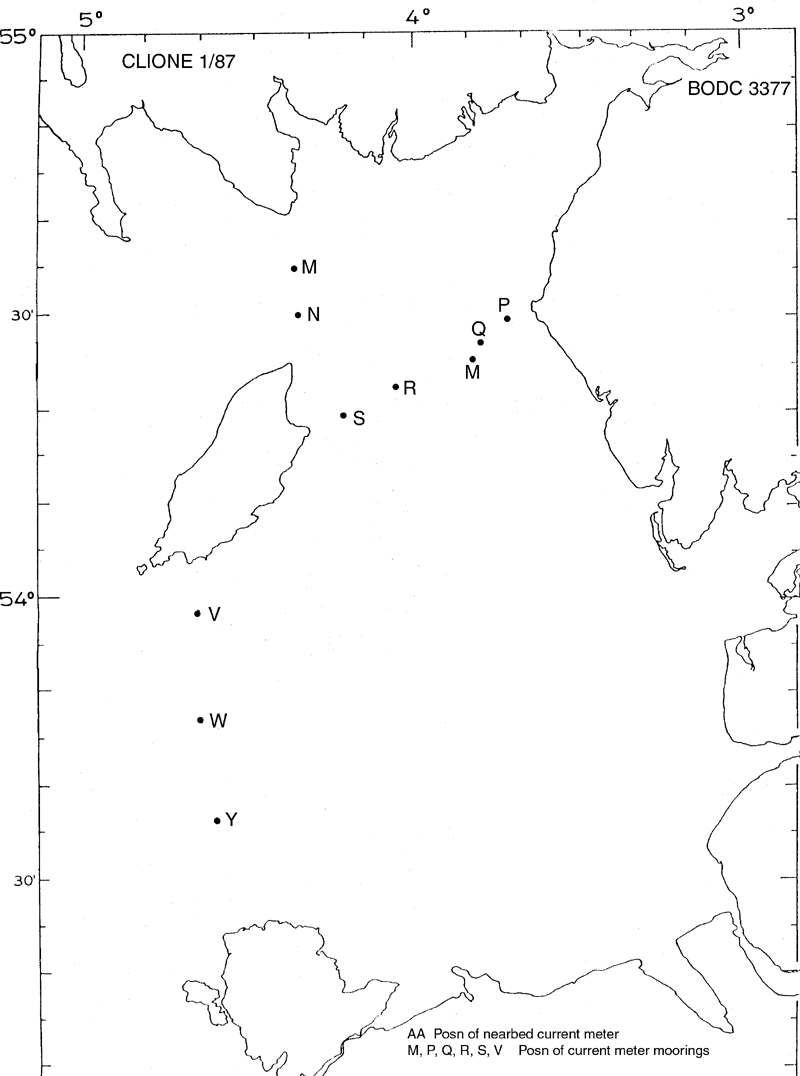
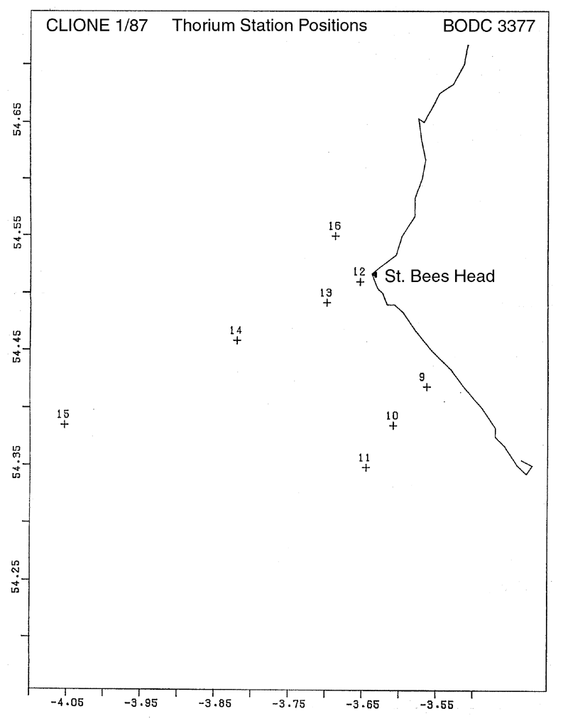
1. To deploy the near bed velocity recorder and its three guard buoys.
2. To deploy six current meter moorings. 3. To collect bottom and surface water samples for thorium analysis plus ancillary sediment samples using box corer and transmissometer profiles at up to 8 stations. 4. To make DCRM, CTD and turbidity measurements and collect suspended sediment samples at hourly intervals for one tidal cycle at anchored stations. 5. To undertake CTD sections between the Isle of Man and the Scottish/English/Welsh coast. 6. To release seabed drifters at two locations east of the Isle of Wight. 7. To collect near suface and near bed water samples for caesium analysis. |
| Ship | RV Clione |
| Departure Port | Lowestoft, United Kingdom |
| Departure Date | 1987-01-07 |
| Arrival Port | Lowestoft, United Kingdom |
| Arrival Date | 1987-01-18 |
| Principal Scientist(s) | Kenneth J Medler (Ministry of Agriculture, Fisheries and Food Lowestoft Fisheries Laboratory) |
| Responsible Organisation | Ministry of Agriculture, Fisheries and Food Lowestoft Fisheries Laboratory |
| Associated Project(s) | |
| IHB Sea Areas Visited | Irish Sea and St. George's Channel |
| Marsden Squares Visited | 181;1 |
| Work Area Description | Eastern Irish Sea/ east of Isle of Wight |
| Unable to lookup cruise bounds at this time | |
| Work Area Bounding Polygon | |
| Southern Limit | unknown |
| Northern Limit | unknown |
| Western Limit | unknown |
| Eastern Limit | unknown |
Cruise Inventory Datasets
| Physical oceanography | |
|---|---|
| CTD stations |
Quantity:
number of stations =
19
Description: |
| Current meters |
Quantity:
number of deployments =
12
Description: deployed only |
| Other physical oceanographic measurements |
Quantity:
number of deployments =
1
Description: nearbed velocity recorder |
| Surface drifters/drifting buoys |
Quantity:
number of deployments =
100
Description: bottom |
| Contamination | |
| Trace metals |
Quantity:
number of samples =
2
Description: |
| Geology and geophysics | |
| Core - soft bottom | Description: |
Cruise Inventory Mooring/Buoy Operations
No information on datasets is currently available
Summary of BODC Data Holdings for the Cruise
National Oceanographic Database
Summary
| # Series | Instrument Description | Parameters |
|---|---|---|
| 19 | CTD/STD cast |
Salinity of the water column Temperature of the water column Vertical spatial coordinates |
Note: Parameter terms are taken from the BODC Parameter Discovery Vocabulary XML (SKOS)
Full List
| BODC Reference | Instrument Description | Date/Time | Location | |
|---|---|---|---|---|
| 178989 | CTD/STD cast | 1987-01-13 10:00Z | 54° 30' N, 3° 39' W | Click for more |
| 178990 | CTD/STD cast | 1987-01-13 13:55Z | 54° 25' N, 3° 33' W | Click for more |
| 179004 | CTD/STD cast | 1987-01-13 15:19Z | 54° 23' N, 3° 36' W | Click for more |
| 179016 | CTD/STD cast | 1987-01-13 17:45Z | 54° 21' N, 3° 39' W | Click for more |
| 179028 | CTD/STD cast | 1987-01-14 09:05Z | 54° 29' N, 3° 42' W | Click for more |
| 179041 | CTD/STD cast | 1987-01-14 10:56Z | 54° 33' N, 3° 41' W | Click for more |
| 179053 | CTD/STD cast | 1987-01-15 07:00Z | 54° 25' N, 3° 49' W | Click for more |
| 179065 | CTD/STD cast | 1987-01-15 07:33Z | 54° 25' N, 3° 49' W | Click for more |
| 179077 | CTD/STD cast | 1987-01-15 08:32Z | 54° 25' N, 3° 49' W | Click for more |
| 179089 | CTD/STD cast | 1987-01-15 09:30Z | 54° 25' N, 3° 49' W | Click for more |
| 179090 | CTD/STD cast | 1987-01-15 10:30Z | 54° 25' N, 3° 49' W | Click for more |
| 179108 | CTD/STD cast | 1987-01-15 11:30Z | 54° 25' N, 3° 49' W | Click for more |
| 179121 | CTD/STD cast | 1987-01-15 12:30Z | 54° 25' N, 3° 49' W | Click for more |
| 179133 | CTD/STD cast | 1987-01-15 13:31Z | 54° 25' N, 3° 49' W | Click for more |
| 179145 | CTD/STD cast | 1987-01-15 14:29Z | 54° 25' N, 3° 49' W | Click for more |
| 179157 | CTD/STD cast | 1987-01-15 15:30Z | 54° 25' N, 3° 49' W | Click for more |
| 179169 | CTD/STD cast | 1987-01-15 16:30Z | 54° 25' N, 3° 49' W | Click for more |
| 179170 | CTD/STD cast | 1987-01-15 17:31Z | 54° 25' N, 3° 49' W | Click for more |
| 179182 | CTD/STD cast | 1987-01-15 18:31Z | 54° 25' N, 3° 49' W | Click for more |
Project Database
No data currently held for this cruise in the BODC Project Database
