BODC Cruise Metadata Report for RRS Discovery (74E3) cruise D169
Introduction
This report collates information from the BODC cruise inventory and oceanographic databases. It presents
- Cruise Inventory Information
- A summary of BODC data holdings for the cruise from the
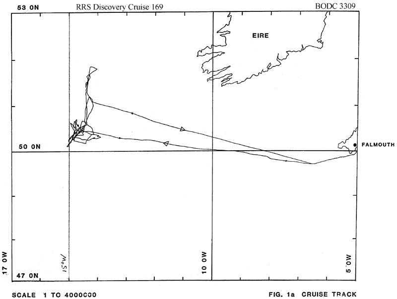
- References - including cruise tracks and cruise reports
Cruise Inventory Information
| Long name | RRS Discovery (74E3) cruise D169 |
|---|---|
| Short name | D169 |
| Objectives and Narrative |
1. To study the structure of the benthic boundary layer on the Western Slope of the Porcupine Bank near 51N 15W using CTD and transmissometer yo-yo's and BERTHA (Benthic Resistance Thermometer Array) with VACM's.
2. To deploy an array of moorings in the 3000-4100m designed to examine the eddy field in deep water near the Continental Slope. 3. To obtain photographic transects using the epibenthic sledge as a photosledge. |
| Ship | RRS Discovery |
| Departure Port | Falmouth, United Kingdom |
| Departure Date | 1987-08-12 |
| Arrival Port | Falmouth, United Kingdom |
| Arrival Date | 1987-08-31 |
| Principal Scientist(s) | Stephen A Thorpe (University of Southampton Department of Oceanography) |
| Responsible Organisation | Institute of Oceanographic Sciences Wormley Laboratory, University of Southampton Department of Oceanography |
| Associated Project(s) | |
| IHB Sea Areas Visited | North East Atlantic Ocean (limit 40W) |
| Marsden Squares Visited | 182;104/182;114/182;205 |
| Work Area Description | N.E. Atlantic |
| Unable to lookup cruise bounds at this time | |
| Work Area Bounding Polygon | |
| Southern Limit | unknown |
| Northern Limit | unknown |
| Western Limit | unknown |
| Eastern Limit | unknown |
Cruise Inventory Datasets
| Physical oceanography | |
|---|---|
| CTD stations |
Quantity:
number of stations =
54
Description: includes transmissometer,also 2 x 25 hours yo-yo series |
| Current meters |
Quantity:
6
Description: 25 deployed;8 days |
| Transparency (eg transmissometer) |
Quantity:
54
Description: includes transmissometer,also 2 x 25 hours yo-yo series |
| Biology and fisheries | |
| Other biological/fisheries measurement |
Quantity:
10
Description: each station was a transect with total photos for cruise of about 2380 |
Cruise Inventory Mooring/Buoy Operations
No information on datasets is currently available
Summary of BODC Data Holdings for the Cruise
National Oceanographic Database
Summary
| # Series | Instrument Description | Parameters |
|---|---|---|
| 15 | CTD/STD cast |
Salinity of the water column Temperature of the water column Transmittance and attenuance of the water column Vertical spatial coordinates |
| 3 | CTD/STD cast |
Temperature of the water column Transmittance and attenuance of the water column Vertical spatial coordinates |
| 1 | CTD/STD cast |
Reference numbers Salinity of the water column Temperature of the water column Transmittance and attenuance of the water column Vertical spatial coordinates |
Note: Parameter terms are taken from the BODC Parameter Discovery Vocabulary XML (SKOS)
Full List
| BODC Reference | Instrument Description | Date/Time | Location | |
|---|---|---|---|---|
| 227339 | CTD/STD cast | 1987-08-13 19:14Z to 1987-08-13 20:49Z | 50° 14' N, 12° 23' W | Click for more |
| 227340 | CTD/STD cast | 1987-08-14 23:48Z to 1987-08-15 00:56Z | 50° 36' N, 14° 22' W | Click for more |
| 227352 | CTD/STD cast | 1987-08-15 02:02Z to 1987-08-15 03:24Z | 50° 33' N, 14° 27' W | Click for more |
| 227364 | CTD/STD cast | 1987-08-15 04:16Z to 1987-08-15 06:09Z | 50° 30' N, 14° 31' W | Click for more |
| 227376 | CTD/STD cast | 1987-08-15 08:30Z to 1987-08-15 10:53Z | 50° 27' N, 14° 34' W | Click for more |
| 227388 | CTD/STD cast | 1987-08-15 12:47Z to 1987-08-15 14:59Z | 50° 24' N, 14° 38' W | Click for more |
| 227407 | CTD/STD cast | 1987-08-15 16:17Z to 1987-08-15 18:34Z | 50° 21' N, 14° 42' W | Click for more |
| 227419 | CTD/STD cast | 1987-08-15 19:39Z to 1987-08-15 22:08Z | 50° 18' N, 14° 47' W | Click for more |
| 227420 | CTD/STD cast | 1987-08-15 23:28Z to 1987-08-16 01:47Z | 50° 15' N, 14° 52' W | Click for more |
| 227432 | CTD/STD cast | 1987-08-16 02:41Z to 1987-08-16 05:13Z | 50° 12' N, 14° 55' W | Click for more |
| 227444 | CTD/STD cast | 1987-08-16 06:00Z to 1987-08-16 08:30Z | 50° 9' N, 14° 59' W | Click for more |
| 227456 | CTD/STD cast | 1987-08-17 21:06Z to 1987-08-17 23:14Z | 50° 26' N, 14° 37' W | Click for more |
| 227468 | CTD/STD cast | 1987-08-18 02:38Z to 1987-08-18 04:32Z | 50° 25' N, 14° 30' W | Click for more |
| 227481 | CTD/STD cast | 1987-08-19 18:52Z to 1987-08-19 19:58Z | 50° 35' N, 14° 23' W | Click for more |
| 227493 | CTD/STD cast | 1987-08-19 23:01Z to 1987-08-20 00:46Z | 50° 30' N, 14° 31' W | Click for more |
| 227500 | CTD/STD cast | 1987-08-20 01:39Z to 1987-08-20 03:38Z | 50° 27' N, 14° 35' W | Click for more |
| 227512 | CTD/STD cast | 1987-08-20 04:32Z to 1987-08-20 06:45Z | 50° 24' N, 14° 39' W | Click for more |
| 227524 | CTD/STD cast | 1987-08-23 20:36Z to 1987-08-23 22:38Z | 50° 24' N, 14° 39' W | Click for more |
| 227536 | CTD/STD cast | 1987-08-25 23:55Z to 1987-08-26 02:21Z | 50° 16' N, 14° 7' W | Click for more |
Project Database
No data currently held for this cruise in the BODC Project Database
