BODC Cruise Metadata Report for RRS Charles Darwin (74AB) cruise CD42
Introduction
This report collates information from the BODC cruise inventory and oceanographic databases. It presents
- Cruise Inventory Information
- A summary of BODC data holdings for the cruise from the
- References - including cruise tracks and cruise reports
Cruise Inventory Information
| Long name | RRS Charles Darwin (74AB) cruise CD42 |
|---|---|
| Short name | CD42 |
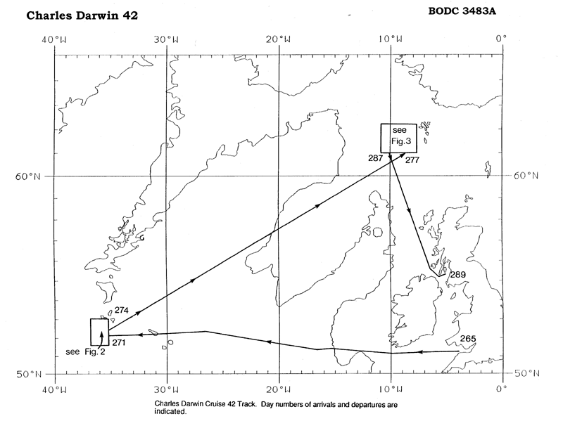
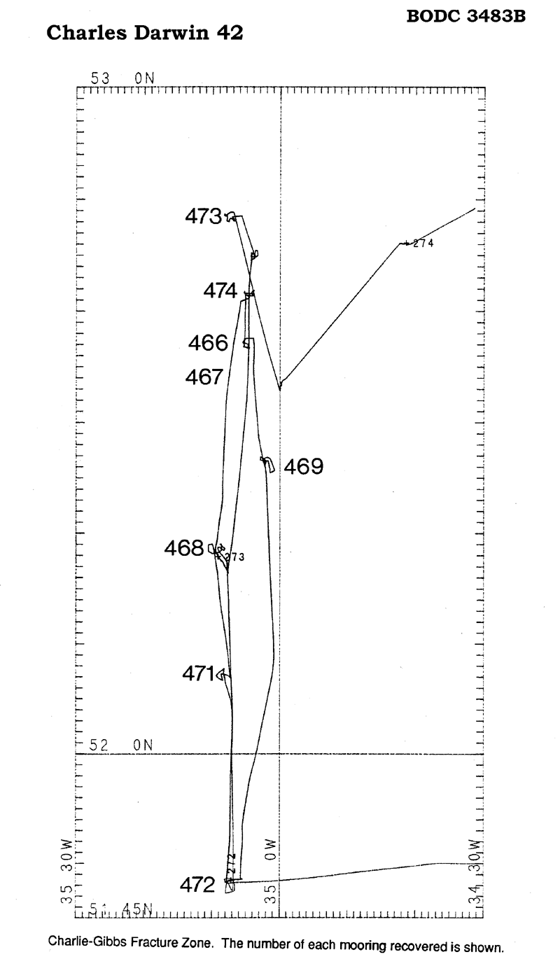
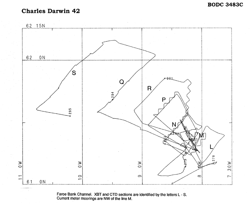
| Objectives and Narrative | The third in a series of cruises concerned with measuring the strength of the overflow of cold dense water from the Norwegian Sea into the eastern North Atlantic and its variability. On this cruise the targeted areas were: (1) the Charlie-Gibbs Fracture Zone, where the cold water leaves the Iceland Basin and passes into the Irminger Basin and (2) the Faeroe Bank Channel, where the cold water enters the Iceland Basin in a persistent inflow. |
| Ship | RRS Charles Darwin |
| Departure Port | Barry, United Kingdom |
| Departure Date | 1989-09-22 |
| Arrival Port | Troon, United Kingdom |
| Arrival Date | 1989-10-16 |
| Principal Scientist(s) | Peter M Saunders (Institute of Oceanographic Sciences Deacon Laboratory) |
| Responsible Organisation | Institute of Oceanographic Sciences Deacon Laboratory |
| Associated Project(s) | |
| IHB Sea Areas Visited | North East Atlantic Ocean (limit 40W) |
| Marsden Squares Visited | 184;1/184;2/217;2/218;1 |
| Work Area Description | North Atlantic Ocean |
| Unable to lookup cruise bounds at this time | |
| Work Area Bounding Polygon | |
| Southern Limit | unknown |
| Northern Limit | unknown |
| Western Limit | unknown |
| Eastern Limit | unknown |
Cruise Inventory Datasets
| Physical oceanography | |
|---|---|
| Bathythermograph |
Quantity:
number of profiles =
60
Description: |
| CTD stations |
Quantity:
number of stations =
26
Description: |
| Current meters |
Quantity:
number of stations =
13
Description: 8 recovered;IOS moorings 466-496 |
| Current profiler (eg ADCP) |
Quantity:
track kilometres =
1852
Description: ADCP |
| Other physical oceanographic measurements |
Quantity:
number of deployments =
2
Description: ATTOM moorings |
| Transparency (eg transmissometer) |
Quantity:
number of stations =
26
Description: at 660nm wavelength on CTD |
| Water bottle stations |
Quantity:
number of stations =
220
Description: surface only |
| Chemical oceanography | |
| Oxygen |
Quantity:
number of samples =
250
Description: |
| Meteorology | |
| Routine standard measurements | Description: |
| Geology and geophysics | |
| Multi-beam echosounding |
Quantity:
track kilometres =
1852
Description: |
Cruise Inventory Mooring/Buoy Operations
No information on datasets is currently available
Summary of BODC Data Holdings for the Cruise
National Oceanographic Database
Summary
| # Series | Instrument Description | Parameters |
|---|---|---|
| 26 | CTD/STD cast |
Dissolved oxygen parameters in the water column Salinity of the water column Temperature of the water column Transmittance and attenuance of the water column Vertical spatial coordinates |
Note: Parameter terms are taken from the BODC Parameter Discovery Vocabulary XML (SKOS)
Full List
| BODC Reference | Instrument Description | Date/Time | Location | |
|---|---|---|---|---|
| 380289 | CTD/STD cast | 1989-09-25 12:37Z to 1989-09-25 13:50Z | 51° 55' N, 19° 45' W | Click for more |
| 380290 | CTD/STD cast | 1989-09-28 22:39Z to 1989-09-28 23:24Z | 51° 48' N, 35° 7' W | Click for more |
| 380308 | CTD/STD cast | 1989-09-29 17:10Z to 1989-09-29 18:23Z | 52° 40' N, 35° 5' W | Click for more |
| 380321 | CTD/STD cast | 1989-09-29 23:09Z to 1989-09-30 00:30Z | 52° 17' N, 35° 9' W | Click for more |
| 380333 | CTD/STD cast | 1989-09-30 12:01Z to 1989-09-30 12:57Z | 52° 48' N, 35° 7' W | Click for more |
| 380345 | CTD/STD cast | 1989-09-30 16:19Z to 1989-09-30 16:21Z | 52° 33' N, 35° 0' W | Click for more |
| 380357 | CTD/STD cast | 1989-10-04 22:05Z to 1989-10-04 22:18Z | 61° 10' N, 7° 46' W | Click for more |
| 380369 | CTD/STD cast | 1989-10-08 19:54Z to 1989-10-08 20:13Z | 61° 27' N, 8° 16' W | Click for more |
| 380370 | CTD/STD cast | 1989-10-08 22:43Z to 1989-10-08 23:05Z | 61° 25' N, 8° 15' W | Click for more |
| 380382 | CTD/STD cast | 1989-10-09 00:59Z to 1989-10-09 01:17Z | 61° 15' N, 8° 2' W | Click for more |
| 380394 | CTD/STD cast | 1989-10-09 02:55Z to 1989-10-09 03:11Z | 61° 22' N, 8° 13' W | Click for more |
| 380401 | CTD/STD cast | 1989-10-10 17:59Z to 1989-10-10 18:24Z | 61° 32' N, 9° 29' W | Click for more |
| 380413 | CTD/STD cast | 1989-10-10 20:19Z to 1989-10-10 20:48Z | 61° 34' N, 9° 45' W | Click for more |
| 380425 | CTD/STD cast | 1989-10-10 22:55Z to 1989-10-10 23:14Z | 61° 39' N, 9° 32' W | Click for more |
| 380437 | CTD/STD cast | 1989-10-11 00:51Z to 1989-10-11 01:04Z | 61° 45' N, 9° 24' W | Click for more |
| 380449 | CTD/STD cast | 1989-10-11 02:52Z to 1989-10-11 03:04Z | 61° 50' N, 9° 13' W | Click for more |
| 380450 | CTD/STD cast | 1989-10-11 04:59Z to 1989-10-11 05:09Z | 61° 56' N, 9° 0' W | Click for more |
| 380462 | CTD/STD cast | 1989-10-11 09:22Z to 1989-10-11 09:38Z | 62° 7' N, 9° 39' W | Click for more |
| 380474 | CTD/STD cast | 1989-10-11 11:09Z to 1989-10-11 11:26Z | 62° 3' N, 9° 52' W | Click for more |
| 380486 | CTD/STD cast | 1989-10-11 13:11Z to 1989-10-11 13:31Z | 61° 57' N, 10° 5' W | Click for more |
| 380498 | CTD/STD cast | 1989-10-11 15:27Z to 1989-10-11 15:44Z | 61° 50' N, 10° 19' W | Click for more |
| 380505 | CTD/STD cast | 1989-10-11 16:55Z to 1989-10-11 17:11Z | 61° 46' N, 10° 24' W | Click for more |
| 380517 | CTD/STD cast | 1989-10-11 19:04Z to 1989-10-11 19:24Z | 61° 42' N, 10° 32' W | Click for more |
| 380529 | CTD/STD cast | 1989-10-11 21:17Z to 1989-10-11 21:39Z | 61° 36' N, 10° 45' W | Click for more |
| 380530 | CTD/STD cast | 1989-10-14 03:01Z to 1989-10-14 03:29Z | 61° 36' N, 10° 22' W | Click for more |
| 380542 | CTD/STD cast | 1989-10-14 05:46Z to 1989-10-14 06:12Z | 61° 43' N, 10° 8' W | Click for more |
Project Database
No data currently held for this cruise in the BODC Project Database
