BODC Cruise Metadata Report for RV Cirolana (74CZ) cruise CIR6/89
Introduction
This report collates information from the BODC cruise inventory and oceanographic databases. It presents
- Cruise Inventory Information
- A summary of BODC data holdings for the cruise from the
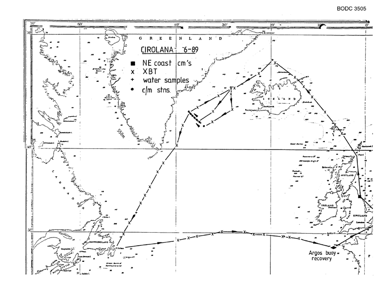
- References - including cruise tracks and cruise reports
Cruise Inventory Information
| Long name | RV Cirolana (74CZ) cruise CIR6/89 |
|---|---|
| Short name | CIR6/89 |
| Objectives and Narrative |
1. To lay a line of 5 current meter moorings off the Tyne for later recovery by CORYSTES.
2. To recover the East Greenland current meter array of 8 moorings (3 current meters per mooring; 2 thermistor chains; 1 Seacat salinity recorder) and relay the array for recovery 1990. 3. To work CTD, Freons (113, 11 and 12) and CCI4 (if available) at a range of locations from the Greenland Sea to the Labrador coast. 4. To conduct near-bottom hydrography of a few days duration at the foot of the Continental Slope of Porcupine Bank. 5. To test-run the PML pCO2 apparatus continuously around the entire cruise track, 6. To work XBTs for MOD (N) at 6-hour intervals throughout the cruise when in water depths > 200m. 7. To collect bulk (50 1) water samples where required for AEP 1 and for ICES nutrient intercalibration work. |
| Ship | RV Cirolana |
| Departure Port | Lowestoft, United Kingdom |
| Departure Date | 1989-06-21 |
| Arrival Port | Lowestoft, United Kingdom |
| Arrival Date | 1989-07-20 |
| Principal Scientist(s) | Robert R Dickson (Ministry of Agriculture, Fisheries and Food Lowestoft Fisheries Laboratory) |
| Responsible Organisation | Ministry of Agriculture, Fisheries and Food Lowestoft Fisheries Laboratory |
| Associated Project(s) | |
| IHB Sea Areas Visited | North East Atlantic Ocean (limit 40W) |
| Marsden Squares Visited | 146;4/147;3/147;4/148;3/148;4/185;2/185;3/217;2/218;4/219;3/219;4/220;1/220;2 |
| Work Area Description | N.W. Atlantic/ North Sea |
| Unable to lookup cruise bounds at this time | |
| Work Area Bounding Polygon | |
| Southern Limit | unknown |
| Northern Limit | unknown |
| Western Limit | unknown |
| Eastern Limit | unknown |
Cruise Inventory Datasets
| Physical oceanography | |
|---|---|
| Bathythermograph |
Quantity:
number of profiles =
49
Description: |
| CTD stations |
Quantity:
number of stations =
19
Description: |
| Current meters |
Quantity:
number of recoveries =
24
Description: recovered/18 deployed;243 days |
| Subsurface temperature and salinity measurements |
Quantity:
number of stations =
2
Description: |
| Surface measurements underway (T,S) | Description: |
| Chemical oceanography | |
| Nitrate |
Quantity:
number of stations =
19
Description: |
| Nitrite |
Quantity:
number of stations =
19
Description: |
| Other dissolved gases |
Quantity:
number of stations =
19
Description: Freons in seawater |
| Oxygen |
Quantity:
number of stations =
19
Description: |
| Phosphate |
Quantity:
number of stations =
19
Description: |
| Silicate |
Quantity:
number of stations =
19
Description: |
Cruise Inventory Mooring/Buoy Operations
No information on datasets is currently available
Summary of BODC Data Holdings for the Cruise
National Oceanographic Database
Summary
| # Series | Instrument Description | Parameters |
|---|---|---|
| 12 | CTD/STD cast |
Salinity of the water column Temperature of the water column Vertical spatial coordinates |
Note: Parameter terms are taken from the BODC Parameter Discovery Vocabulary XML (SKOS)
Full List
| BODC Reference | Instrument Description | Date/Time | Location | |
|---|---|---|---|---|
| 326116 | CTD/STD cast | 1989-06-26 08:56Z | 68° 12' N, 19° 43' W | Click for more |
| 326128 | CTD/STD cast | 1989-06-27 09:51Z | 65° 51' N, 28° 15' W | Click for more |
| 326141 | CTD/STD cast | 1989-06-30 14:10Z | 65° 49' N, 28° 17' W | Click for more |
| 326153 | CTD/STD cast | 1989-06-30 15:10Z | 65° 51' N, 28° 16' W | Click for more |
| 326165 | CTD/STD cast | 1989-06-30 18:49Z | 65° 52' N, 28° 12' W | Click for more |
| 326177 | CTD/STD cast | 1989-07-02 07:03Z | 62° 54' N, 35° 7' W | Click for more |
| 326189 | CTD/STD cast | 1989-07-02 19:03Z | 63° 7' N, 35° 33' W | Click for more |
| 326190 | CTD/STD cast | 1989-07-03 06:58Z | 63° 16' N, 35° 53' W | Click for more |
| 326208 | CTD/STD cast | 1989-07-03 18:38Z | 63° 28' N, 36° 18' W | Click for more |
| 326221 | CTD/STD cast | 1989-07-04 07:01Z | 63° 37' N, 36° 43' W | Click for more |
| 326233 | CTD/STD cast | 1989-07-05 05:53Z | 63° 40' N, 37° 1' W | Click for more |
| 326245 | CTD/STD cast | 1989-07-08 11:32Z | 52° 28' N, 48° 13' W | Click for more |
Project Database
No data currently held for this cruise in the BODC Project Database
