BODC Cruise Metadata Report for RRS Discovery (74E3) cruise D181
Introduction
This report collates information from the BODC cruise inventory and oceanographic databases. It presents
- Cruise Inventory Information
- A summary of BODC data holdings for the cruise from the
- References - including cruise tracks and cruise reports
Cruise Inventory Information
| Long name | RRS Discovery (74E3) cruise D181 |
|---|---|
| Short name | D181 |
| Objectives and Narrative |
1. Quantify the circulation of the Biscay region northeast of 41N, 30W with a box of full depth CTD casts at about 75km intervals along the sections. Sampling will include nutrients (nitrates, phosphates and silicates), chlorophyll 'a' and bacterial counts. Vertical net samples will also be taken during selected CTDs for BOFS.
2. Conduct SeaSoar trials to test various modifications to the fairing, fish and depressor, designed to improve its performance and increase its maximum depth and duration of tow; also to test improved editing and display software. 3. Run SeaSoar sections within the CTD survey box to quantify variations of the T/S characteristics of newly ventilated winter Mode water. 4. Run a SeaSoar section from 47N to 60N along the BOFs line at 20W to examine the latitudinal variation of mixed layer depth, the horizontal statistics of eddy and frontal activity, and the variability of upper ocean properties (temperature, salinity, oxygen and chlorophyll 'a'). 5. Continuously sample surface parameters to examine the spatial (and temporal) variability of temperature, salinity and fluorescence. 6. Deploy and recover a short term mooring (4 weeks) to observe internal tidal wave propagation off the Celtic shelf. 7. Deploy a two year trial mooring close to 6. 8. Recover two moorings from the shelf edge off the north coast of Spain. 9. Deploy sediment traps at 47N, 20W for BOFS. |
| Ship | RRS Discovery |
| Departure Port | Barry, United Kingdom |
| Departure Date | 1989-04-01 |
| Arrival Port | Barry, United Kingdom |
| Arrival Date | 1989-05-03 |
| Principal Scientist(s) | Raymond T Pollard (Institute of Oceanographic Sciences Deacon Laboratory) |
| Responsible Organisation | Institute of Oceanographic Sciences Deacon Laboratory |
| Associated Project(s) | BOFS |
| IHB Sea Areas Visited | Bay of Biscay, North East Atlantic Ocean (limit 40W) |
| Marsden Squares Visited | 145/146/147/182 |
| Work Area Description | Bay of Biscay - 20řW |
| Unable to lookup cruise bounds at this time | |
| Work Area Bounding Polygon | |
| Southern Limit | unknown |
| Northern Limit | unknown |
| Western Limit | unknown |
| Eastern Limit | unknown |
Cruise Inventory Datasets
| Physical oceanography | |
|---|---|
| Bathythermograph |
Quantity:
number of profiles =
31
Description: |
| CTD stations |
Quantity:
number of stations =
58
Description: |
| Current meters |
Quantity:
number of deployments =
3
Description: 23 (211d) |
| Current profiler (eg ADCP) | Description: ADCP |
| Subsurface temperature and salinity measurements |
Quantity:
track kilometres =
3111
Description: Seasoar |
| Surface drifters/drifting buoys |
Quantity:
number of deployments =
4
Description: Argos Buoys |
| Surface measurements underway (T,S) | Description: |
| Chemical oceanography | |
| Nitrate | Description: |
| Oxygen | Description: |
| Biology and fisheries | |
| Particulate organic matter (inc POC, PON) | Description: POC & PON |
| Phytoplankton | Description: Lugols |
| Phytoplankton pigs (eg chlorophyll, fluorescence) | Description: |
| Seston |
Quantity:
number of hauls =
7
Description: apstein nets |
| Zooplankton | Description: WP2 nets,formalin |
| Meteorology | |
| Incident radiation | Description: 2 minute samples |
| Other meteorological measurements | Description: hourly wind speed and direction |
Cruise Inventory Mooring/Buoy Operations
No information on datasets is currently available
Summary of BODC Data Holdings for the Cruise
National Oceanographic Database
Summary
| # Series | Instrument Description | Parameters |
|---|---|---|
| 12 | CTD in towed or autonomous underwater vehicle |
Data are currently being processed |
| 48 | CTD/STD cast |
Dissolved oxygen parameters in the water column Electrical conductivity of the water column Salinity of the water column Temperature of the water column Transmittance and attenuance of the water column Vertical spatial coordinates |
| 10 | CTD/STD cast |
Dissolved oxygen parameters in the water column Electrical conductivity of the water column Reference numbers Salinity of the water column Temperature of the water column Transmittance and attenuance of the water column Vertical spatial coordinates |
Note: Parameter terms are taken from the BODC Parameter Discovery Vocabulary XML (SKOS)
Full List
| BODC Reference | Instrument Description | Date/Time | Location | |
|---|---|---|---|---|
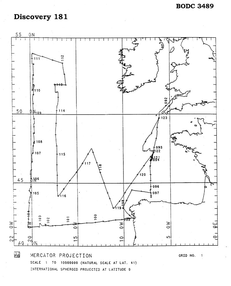
| 291330 | CTD/STD cast | 1989-04-02 10:21Z to 1989-04-02 11:08Z | 49° 11' N, 6° 14' W | Click for more |
| 291342 | CTD/STD cast | 1989-04-03 01:28Z to 1989-04-03 02:20Z | 47° 27' N, 6° 37' W | Click for more |
| 291354 | CTD/STD cast | 1989-04-03 04:04Z to 1989-04-03 06:57Z | 47° 17' N, 6° 39' W | Click for more |
| 291366 | CTD/STD cast | 1989-04-03 08:30Z to 1989-04-03 11:29Z | 47° 17' N, 6° 40' W | Click for more |
| 291378 | CTD/STD cast | 1989-04-04 09:06Z to 1989-04-04 10:40Z | 46° 42' N, 6° 58' W | Click for more |
| 291391 | CTD/STD cast | 1989-04-05 05:31Z to 1989-04-05 06:32Z | 46° 17' N, 7° 1' W | Click for more |
| 291409 | CTD/STD cast | 1989-04-05 12:45Z to 1989-04-05 13:53Z | 45° 33' N, 7° 0' W | Click for more |
| 291410 | CTD/STD cast | 1989-04-05 18:57Z to 1989-04-05 19:46Z | 45° 4' N, 7° 0' W | Click for more |
| 291422 | CTD/STD cast | 1989-04-06 05:43Z to 1989-04-06 06:32Z | 44° 29' N, 7° 1' W | Click for more |
| 291434 | CTD/STD cast | 1989-04-06 19:05Z to 1989-04-06 19:21Z | 44° 0' N, 6° 57' W | Click for more |
| 291446 | CTD/STD cast | 1989-04-06 19:44Z to 1989-04-06 20:23Z | 44° 1' N, 6° 58' W | Click for more |
| 291458 | CTD/STD cast | 1989-04-06 22:11Z to 1989-04-06 23:01Z | 44° 13' N, 6° 58' W | Click for more |
| 291471 | CTD/STD cast | 1989-04-07 10:52Z to 1989-04-07 11:40Z | 44° 29' N, 9° 0' W | Click for more |
| 291483 | CTD/STD cast | 1989-04-07 22:05Z to 1989-04-07 22:14Z | 43° 5' N, 10° 0' W | Click for more |
| 291495 | CTD/STD cast | 1989-04-08 12:10Z to 1989-04-08 12:22Z | 42° 15' N, 9° 13' W | Click for more |
| 291502 | CTD/STD cast | 1989-04-08 14:13Z to 1989-04-08 14:28Z | 43° 15' N, 9° 27' W | Click for more |
| 291514 | CTD/STD cast | 1989-04-08 14:59Z to 1989-04-08 15:30Z | 43° 15' N, 9° 29' W | Click for more |
| 291526 | CTD/STD cast | 1989-04-08 20:50Z to 1989-04-08 21:28Z | 42° 13' N, 9° 40' W | Click for more |
| 291538 | CTD/STD cast | 1989-04-09 01:44Z to 1989-04-09 02:28Z | 42° 9' N, 10° 19' W | Click for more |
| 291551 | CTD/STD cast | 1989-04-09 08:18Z to 1989-04-09 08:57Z | 42° 6' N, 11° 13' W | Click for more |
| 291563 | CTD/STD cast | 1989-04-09 15:27Z to 1989-04-09 16:28Z | 42° 1' N, 12° 7' W | Click for more |
| 291575 | CTD/STD cast | 1989-04-09 21:59Z | 41° 57' N, 13° 0' W | Click for more |
| 291587 | CTD/STD cast | 1989-04-10 05:40Z to 1989-04-10 06:34Z | 41° 54' N, 13° 55' W | Click for more |
| 291599 | CTD/STD cast | 1989-04-10 12:07Z to 1989-04-10 13:03Z | 41° 51' N, 14° 46' W | Click for more |
| 291606 | CTD/STD cast | 1989-04-10 20:07Z to 1989-04-10 21:03Z | 41° 47' N, 15° 40' W | Click for more |
| 291618 | CTD/STD cast | 1989-04-11 04:23Z to 1989-04-11 05:23Z | 41° 43' N, 16° 33' W | Click for more |
| 291631 | CTD/STD cast | 1989-04-11 13:55Z to 1989-04-11 14:47Z | 41° 40' N, 17° 27' W | Click for more |
| 291643 | CTD/STD cast | 1989-04-12 11:42Z to 1989-04-12 13:09Z | 41° 39' N, 18° 24' W | Click for more |
| 291655 | CTD/STD cast | 1989-04-13 03:36Z to 1989-04-13 04:30Z | 41° 34' N, 19° 13' W | Click for more |
| 291667 | CTD/STD cast | 1989-04-13 12:16Z to 1989-04-13 13:07Z | 41° 32' N, 20° 19' W | Click for more |
| 291679 | CTD/STD cast | 1989-04-13 21:06Z to 1989-04-13 21:58Z | 42° 10' N, 20° 18' W | Click for more |
| 291680 | CTD/STD cast | 1989-04-14 04:14Z to 1989-04-14 04:57Z | 42° 48' N, 20° 13' W | Click for more |
| 291692 | CTD/STD cast | 1989-04-14 10:54Z to 1989-04-14 11:51Z | 43° 26' N, 20° 9' W | Click for more |
| 291711 | CTD/STD cast | 1989-04-14 20:24Z to 1989-04-14 21:15Z | 44° 4' N, 20° 3' W | Click for more |
| 291723 | CTD/STD cast | 1989-04-15 15:49Z to 1989-04-15 16:42Z | 44° 43' N, 19° 59' W | Click for more |
| 291735 | CTD/STD cast | 1989-04-16 00:10Z to 1989-04-16 01:15Z | 45° 19' N, 19° 57' W | Click for more |
| 291747 | CTD/STD cast | 1989-04-16 08:30Z to 1989-04-16 09:22Z | 45° 58' N, 19° 52' W | Click for more |
| 291759 | CTD/STD cast | 1989-04-16 17:11Z to 1989-04-16 18:03Z | 46° 35' N, 19° 46' W | Click for more |
| 291760 | CTD/STD cast | 1989-04-16 23:24Z to 1989-04-17 00:17Z | 47° 13' N, 19° 42' W | Click for more |
| 291772 | CTD/STD cast | 1989-04-17 18:04Z to 1989-04-17 18:27Z | 47° 58' N, 19° 32' W | Click for more |
| 291784 | CTD/STD cast | 1989-04-17 21:09Z to 1989-04-17 22:11Z | 48° 2' N, 19° 33' W | Click for more |
| 291796 | CTD/STD cast | 1989-04-18 06:48Z to 1989-04-18 07:41Z | 48° 39' N, 19° 31' W | Click for more |
| 291803 | CTD/STD cast | 1989-04-18 13:31Z to 1989-04-18 14:24Z | 49° 20' N, 19° 32' W | Click for more |
| 291815 | CTD/STD cast | 1989-04-18 20:49Z to 1989-04-18 21:47Z | 50° 1' N, 19° 34' W | Click for more |
| 291827 | CTD/STD cast | 1989-04-19 03:20Z to 1989-04-19 04:14Z | 50° 40' N, 19° 37' W | Click for more |
| 291839 | CTD/STD cast | 1989-04-19 09:34Z to 1989-04-19 10:32Z | 51° 19' N, 19° 33' W | Click for more |
| 291840 | CTD/STD cast | 1989-04-19 15:56Z to 1989-04-19 16:49Z | 51° 59' N, 19° 33' W | Click for more |
| 291852 | CTD/STD cast | 1989-04-20 09:31Z to 1989-04-20 10:12Z | 52° 39' N, 19° 36' W | Click for more |
| 291864 | CTD/STD cast | 1989-04-20 18:42Z to 1989-04-20 19:20Z | 53° 19' N, 19° 34' W | Click for more |
| 291876 | CTD/STD cast | 1989-04-21 04:36Z to 1989-04-21 05:00Z | 54° 0' N, 19° 36' W | Click for more |
| 291888 | CTD/STD cast | 1989-04-21 10:24Z to 1989-04-21 11:01Z | 53° 48' N, 18° 30' W | Click for more |
| 291907 | CTD/STD cast | 1989-04-21 16:37Z to 1989-04-21 17:13Z | 53° 36' N, 17° 25' W | Click for more |
| 291919 | CTD/STD cast | 1989-04-21 22:19Z to 1989-04-21 23:03Z | 53° 25' N, 16° 21' W | Click for more |
| 291920 | CTD/STD cast | 1989-04-22 05:00Z to 1989-04-22 05:55Z | 52° 42' N, 16° 9' W | Click for more |
| 291932 | CTD/STD cast | 1989-04-22 11:57Z to 1989-04-22 12:45Z | 52° 0' N, 16° 1' W | Click for more |
| 291944 | CTD/STD cast | 1989-04-22 18:30Z to 1989-04-22 19:21Z | 52° 0' N, 17° 11' W | Click for more |
| 291956 | CTD/STD cast | 1989-04-30 18:18Z to 1989-04-30 19:09Z | 47° 18' N, 6° 42' W | Click for more |
| 291968 | CTD/STD cast | 1989-05-01 01:32Z to 1989-05-01 02:25Z | 46° 43' N, 6° 48' W | Click for more |
| 365489 | CTD in towed or autonomous underwater vehicle | 1989-04-09 10:09Z | 42° 5' N, 11° 13' W | Click for more |
| 365490 | CTD in towed or autonomous underwater vehicle | 1989-04-10 14:44Z | 41° 51' N, 14° 48' W | Click for more |
| 365508 | CTD in towed or autonomous underwater vehicle | 1989-04-13 14:50Z | 41° 31' N, 20° 19' W | Click for more |
| 365521 | CTD in towed or autonomous underwater vehicle | 1989-04-14 13:57Z | 43° 26' N, 20° 10' W | Click for more |
| 365533 | CTD in towed or autonomous underwater vehicle | 1989-04-16 11:04Z | 45° 58' N, 19° 52' W | Click for more |
| 365545 | CTD in towed or autonomous underwater vehicle | 1989-04-23 05:14Z | 51° 55' N, 17° 9' W | Click for more |
| 365557 | CTD in towed or autonomous underwater vehicle | 1989-05-01 23:43Z | 47° 23' N, 6° 46' W | Click for more |
| 365569 | CTD in towed or autonomous underwater vehicle | 1989-04-28 21:20Z | 43° 3' N, 10° 58' W | Click for more |
| 365570 | CTD in towed or autonomous underwater vehicle | 1989-04-27 09:00Z | 47° 35' N, 13° 18' W | Click for more |
| 365582 | CTD in towed or autonomous underwater vehicle | 1989-04-25 21:00Z | 43° 58' N, 16° 58' W | Click for more |
| 365594 | CTD in towed or autonomous underwater vehicle | 1989-04-24 02:09Z | 49° 52' N, 17° 4' W | Click for more |
| 365601 | CTD in towed or autonomous underwater vehicle | 1989-04-19 20:45Z | 51° 58' N, 19° 28' W | Click for more |
Project Database
| # Events | Gear Type | Parameters Held |
|---|---|---|
| 1 | Instrument mooring |
Concentration of silicon species in suspended particulate material
Sedimentation flux of metallic and metalloid elements and isotopes in water bodies Carbon concentrations in suspended particulate material Sedimentation flux of carbon, nitrogen or organic matter in the water column Nitrogen concentrations in suspended particulate material Radioactivity in water bodies Sedimentation flux quantification in the water column Sedimentation flux of non-metallic inorganic species in the water column |
Note: Parameter terms are taken from the BODC Parameter Discovery Vocabulary XML (SKOS)
