BODC Cruise Metadata Report for RRS Charles Darwin (74AB) cruise CD51
Introduction
This report collates information from the BODC cruise inventory and oceanographic databases. It presents
- Cruise Inventory Information
- A summary of BODC data holdings for the cruise from the
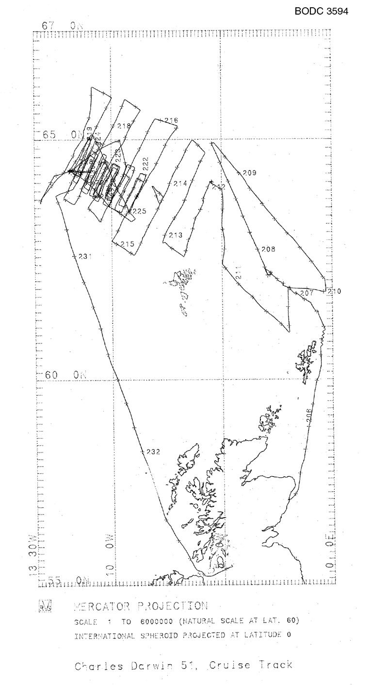
- References - including cruise tracks and cruise reports
Cruise Inventory Information
| Long name | RRS Charles Darwin (74AB) cruise CD51 |
|---|---|
| Short name | CD51 |
| Objectives and Narrative | The cruise gathered information for an IOSDL Laboratory Research Project on "Processes Determining the Structure of the Upper Ocean" and formed part of the UK contribution to the WOCE. The operational area covered the inflow of North Atlantic Water to the Greenland-Iceland-Norwegian Sea between the Shetlands and Iceland. The survey method involved towing a CTD inside the SeaSoar profiling vehicle and combining the data with the shipboard ADCP. Two wide area surveys, one east of, and one west of, the Faeroes were completed. The evolving eddy structure of the Iceland-Faeroes Front was then examined by three repeated small scale surveys. |
| Ship | RRS Charles Darwin |
| Departure Port | Aberdeen, United Kingdom |
| Departure Date | 1990-07-24 |
| Arrival Port | Troon, United Kingdom |
| Arrival Date | 1990-08-21 |
| Principal Scientist(s) | Gwyn Griffiths (Institute of Oceanographic Sciences Deacon Laboratory) |
| Responsible Organisation | Institute of Oceanographic Sciences Deacon Laboratory |
| Associated Project(s) | WOCE |
| IHB Sea Areas Visited | Norwegian Sea, North East Atlantic Ocean (limit 40W) |
| Marsden Squares Visited | 217;1/217;2/217;3/217;4/218;1/218;3 |
| Work Area Description | Iceland/Faroes |
| Unable to lookup cruise bounds at this time | |
| Work Area Bounding Polygon | |
| Southern Limit | unknown |
| Northern Limit | unknown |
| Western Limit | unknown |
| Eastern Limit | unknown |
Cruise Inventory Datasets
| Physical oceanography | |
|---|---|
| Bathythermograph |
Quantity:
number of profiles =
13
Description: XBT |
| CTD stations |
Quantity:
number of profiles =
18
Description: |
| Current profiler (eg ADCP) |
Quantity:
track kilometres =
8800
Description: RDI shipboard, current profiles to 400m |
| Other physical oceanographic measurements |
Quantity:
number of images =
50
Description: onboard reception of satellite visible and IR images |
| Subsurface temperature and salinity measurements |
Quantity:
track kilometres =
6650
Description: NBIS CTD and Chelsea Instruments fluorometer in SeaSoar |
| Surface measurements underway (T,S) |
Quantity:
track kilometres =
8800
Description: thermosalinograph |
| Transparency (eg transmissometer) |
Quantity:
number of profiles =
18
Description: SeaTech transmissometer attached to CTD |
| Water bottle stations |
Quantity:
number of profiles =
18
Description: |
| Chemical oceanography | |
| Oxygen |
Quantity:
number of profiles =
18
Description: Oxygen probe attached to CTD and General Oceanics multisampler for O2 samples |
| Oxygen | Description: water samples for oxygen calibration of CTD |
| Biology and fisheries | |
| Phytoplankton pigs (eg chlorophyll, fluorescence) | Description: water samples for chlorophyll analysis |
| Phytoplankton pigs (eg chlorophyll, fluorescence) |
Quantity:
track kilometres =
8000
Description: surface fluorescence |
| Meteorology | |
| Other meteorological measurements |
Quantity:
number of images =
50
Description: onboard reception of satellite visible and IR images |
| Routine standard measurements |
Quantity:
activity duration in days =
28
Description: high accuracy meteorological data for research purposes |
| Routine standard measurements |
Quantity:
activity duration in days =
28
Description: routine meteorological reports, voluntary observing ship |
Cruise Inventory Mooring/Buoy Operations
| Latitude | Longitude | Data type | Description |
|---|---|---|---|
| 64° 22' N | 11° 54' W | Current meters | Recovery of S4 and Aanderaa current meters, 16 August 1990 |
| 64° 22' N | 11° 54' W | Current profiler (eg ADCP) | Recovery of RDI 150kHz ADCP, bottom mounted, 16 August 1990 |
| 64° 18' N | 12° 37' W | Surface drifters/drifting buoys | ARGOS drifter for current measurement, drogued at 10m, deployed 08 August 1990 |
| 64° 58' N | 9° 37' W | Surface drifters/drifting buoys | Recovery of ARGOS drifter, 16 August 1990 |
Summary of BODC Data Holdings for the Cruise
National Oceanographic Database
Summary
| # Series | Instrument Description | Parameters |
|---|---|---|
| 4 | CTD in towed or autonomous underwater vehicle |
Data are currently being processed |
| 4 | CTD/STD cast |
Dissolved oxygen parameters in the water column Electrical conductivity of the water column Salinity of the water column Temperature of the water column Transmittance and attenuance of the water column Vertical spatial coordinates |
| 18 | CTD/STD cast |
Density of the water column Dissolved oxygen parameters in the water column Electrical conductivity of the water column Raw suspended particulate material concentration sensor output Salinity of the water column Temperature of the water column Vertical spatial coordinates |
Note: Parameter terms are taken from the BODC Parameter Discovery Vocabulary XML (SKOS)
Full List
| BODC Reference | Instrument Description | Date/Time | Location | |
|---|---|---|---|---|
| 431469 | CTD in towed or autonomous underwater vehicle | 1990-08-09 18:00:00Z to 1990-08-12 15:00:00Z | From 63° 35' N, 9° 13' W to 65° 6' N, 10° 55' W | Click for more |
| 431470 | CTD in towed or autonomous underwater vehicle | 1990-08-13 00:00:00Z to 1990-08-15 21:00:00Z | From 63° 36' N, 9° 15' W to 65° 0' N, 10° 58' W | Click for more |
| 431482 | CTD in towed or autonomous underwater vehicle | 1990-08-16 18:00:00Z to 1990-08-18 15:00:00Z | From 64° 27' N, 9° 21' W to 63° 55' N, 12° 27' W | Click for more |
| 431494 | CTD in towed or autonomous underwater vehicle | 1990-07-31 21:00:00Z to 1990-08-08 06:00:00Z | From 62° 57' N, 7° 38' W to 63° 49' N, 13° 13' W | Click for more |
| 474193 | CTD/STD cast | 1990-07-25 17:16Z | 61° 30' N, 0° 42' W | Click for more |
| 474200 | CTD/STD cast | 1990-07-25 19:33Z | 61° 40' N, 0° 59' W | Click for more |
| 474212 | CTD/STD cast | 1990-07-25 21:26Z | 61° 46' N, 1° 19' W | Click for more |
| 474224 | CTD/STD cast | 1990-07-25 23:43Z | 61° 53' N, 1° 39' W | Click for more |
| 474236 | CTD/STD cast | 1990-07-26 02:10Z | 62° 0' N, 1° 55' W | Click for more |
| 474248 | CTD/STD cast | 1990-07-26 04:46Z | 62° 6' N, 2° 13' W | Click for more |
| 474261 | CTD/STD cast | 1990-07-26 07:33Z | 62° 12' N, 2° 31' W | Click for more |
| 474273 | CTD/STD cast | 1990-07-26 10:41Z | 62° 18' N, 2° 46' W | Click for more |
| 474285 | CTD/STD cast | 1990-07-26 13:09Z | 62° 25' N, 3° 4' W | Click for more |
| 474297 | CTD/STD cast | 1990-07-30 21:57Z | 64° 10' N, 5° 32' W | Click for more |
| 474304 | CTD/STD cast | 1990-07-31 00:42Z | 63° 59' N, 5° 43' W | Click for more |
| 474316 | CTD/STD cast | 1990-07-31 03:37Z | 63° 47' N, 5° 51' W | Click for more |
| 474328 | CTD/STD cast | 1990-07-31 06:22Z | 63° 36' N, 6° 1' W | Click for more |
| 474341 | CTD/STD cast | 1990-07-31 09:26Z | 63° 25' N, 6° 14' W | Click for more |
| 474353 | CTD/STD cast | 1990-07-31 12:10Z | 63° 13' N, 6° 20' W | Click for more |
| 474365 | CTD/STD cast | 1990-07-31 14:45Z | 63° 0' N, 6° 31' W | Click for more |
| 474377 | CTD/STD cast | 1990-07-31 16:56Z | 62° 51' N, 6° 37' W | Click for more |
| 474389 | CTD/STD cast | 1990-07-31 18:54Z | 62° 39' N, 6° 45' W | Click for more |
| 474390 | CTD/STD cast | 1990-07-26 20:00Z | 63° 36' N, 4° 7' W | Click for more |
| 474408 | CTD/STD cast | 1990-07-27 18:28Z | 63° 24' N, 2° 32' W | Click for more |
| 474421 | CTD/STD cast | 1990-07-28 23:42Z | 61° 31' N, 1° 10' W | Click for more |
| 474433 | CTD/STD cast | 1990-07-29 13:15Z | 62° 37' N, 3° 45' W | Click for more |
Project Database
No data currently held for this cruise in the BODC Project Database
