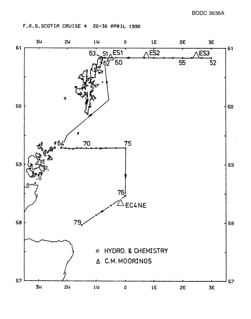
BODC Cruise Metadata Report for FRV Scotia (749S) cruise 0490S_1
Introduction
This report collates information from the BODC cruise inventory and oceanographic databases. It presents
- Cruise Inventory Information
- A summary of BODC data holdings for the cruise from the
- References - including cruise tracks and cruise reports
Cruise Inventory Information
| Long name | FRV Scotia (749S) cruise 0490S_1 |
|---|---|
| Short name | 0490S_1 |
| Objectives and Narrative |
(1) To deploy five current meter moorings.
(2) To repeat the hydrographic survey performed during Scotia cruise 13/89 Part 2. (3) To test the shipborne ADCP. (4) To collect caesium samples. |
| Ship | FRV Scotia |
| Departure Port | Greenock, United Kingdom |
| Departure Date | 1990-04-20 |
| Arrival Port | Aberdeen, United Kingdom |
| Arrival Date | 1990-04-30 |
| Principal Scientist(s) | Bill Turrell (Scottish Office Agriculture and Fisheries Department Aberdeen Marine Laboratory) |
| Responsible Organisation | Scottish Office Agriculture and Fisheries Department Aberdeen Marine Laboratory |
| Associated Project(s) | |
| IHB Sea Areas Visited | North Sea |
| Marsden Squares Visited | 181;3/217;1/252;1 |
| Work Area Description | Fair Isle, Orkney and east of Shetland |
| Unable to lookup cruise bounds at this time | |
| Work Area Bounding Polygon | |
| Southern Limit | unknown |
| Northern Limit | unknown |
| Western Limit | unknown |
| Eastern Limit | unknown |
Cruise Inventory Datasets
| Physical oceanography | |
|---|---|
| CTD stations |
Quantity:
number of profiles =
28
Description: |
| Current meters |
Quantity:
number of stations =
6
Description: 12 cms deployed |
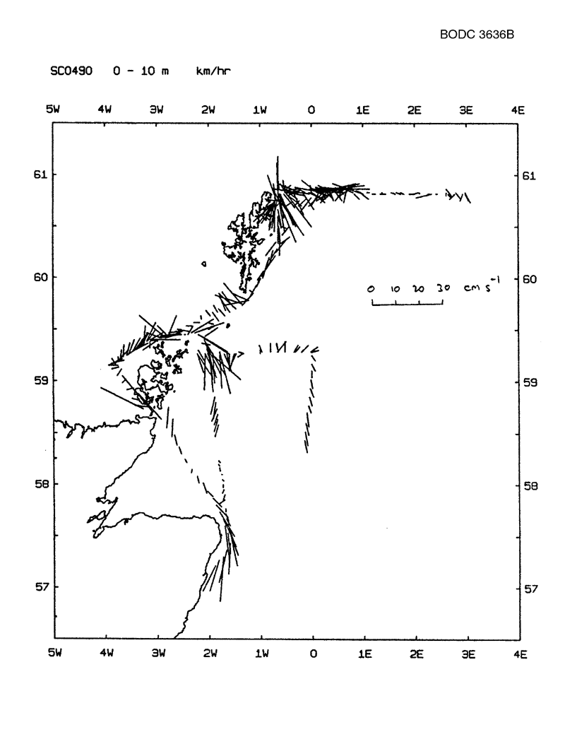
| Current profiler (eg ADCP) | Description: shipborne ADCP all cruise |
| Sea level (inc. bot. press., inverted echosounder) |
Quantity:
number of deployments =
2
Description: |
| Surface measurements underway (T,S) | Description: entire duration of cruise |
| Water bottle stations |
Quantity:
number of stations =
13
Description: |
| Chemical oceanography | |
| Nitrate |
Quantity:
number of samples =
25
Description: |
| Phosphate |
Quantity:
number of samples =
25
Description: |
| Radioactivity |
Quantity:
number of samples =
2
Description: |
| Silicate |
Quantity:
number of samples =
25
Description: |
Cruise Inventory Mooring/Buoy Operations
| Latitude | Longitude | Data type | Description |
|---|---|---|---|
| 58° 21' N | 0° 10' W | Current meters | laid mooring ec4ne with 2cm and wlr due up october |
| 60° 51' N | 0° 30' W | Current meters | laid mooring es1 with 2cm due up october |
| 60° 52' N | 0° 43' E | Current meters | laid mooring es2 with 2cm and wlr due up october |
| 60° 53' N | 2° 28' E | Current meters | laid mooring es3 with 2 cm due up october |
| 59° 9' N | 3° 56' W | Current meters | laid mooring woc with 2cm due up october |
| 60° 53' N | 2° 28' E | Current meters | mooring es3 struck by trawler c 10.7.90. 2cm recovered. |
| 58° 21' N | 0° 10' W | Sea level (inc. bot. press., inverted echosounder) | laid mooring ec4ne with 2cm and wlr due up october |
| 63° 52' N | 0° 43' E | Sea level (inc. bot. press., inverted echosounder) |
Summary of BODC Data Holdings for the Cruise
National Oceanographic Database
Summary
| # Series | Instrument Description | Parameters |
|---|---|---|
| 28 | CTD/STD cast |
Density of the water column Electrical conductivity of the water column Salinity of the water column Temperature of the water column Vertical spatial coordinates |
Note: Parameter terms are taken from the BODC Parameter Discovery Vocabulary XML (SKOS)
Full List
| BODC Reference | Instrument Description | Date/Time | Location | |
|---|---|---|---|---|
| 409396 | CTD/STD cast | 1990-04-27 19:04Z | 60° 49' N, 3° 0' E | Click for more |
| 409403 | CTD/STD cast | 1990-04-27 20:37Z | 60° 49' N, 2° 40' E | Click for more |
| 409415 | CTD/STD cast | 1990-04-27 21:51Z | 60° 49' N, 2° 19' E | Click for more |
| 409427 | CTD/STD cast | 1990-04-27 23:04Z | 60° 49' N, 2° 0' E | Click for more |
| 409439 | CTD/STD cast | 1990-04-28 00:17Z | 60° 49' N, 1° 39' E | Click for more |
| 409440 | CTD/STD cast | 1990-04-28 01:31Z | 60° 49' N, 1° 19' E | Click for more |
| 409452 | CTD/STD cast | 1990-04-28 02:54Z | 60° 49' N, 1° 0' E | Click for more |
| 409464 | CTD/STD cast | 1990-04-28 04:14Z | 60° 49' N, 0° 40' E | Click for more |
| 409476 | CTD/STD cast | 1990-04-28 08:28Z | 60° 49' N, 0° 20' W | Click for more |
| 409488 | CTD/STD cast | 1990-04-28 09:51Z | 60° 49' N, 0° 30' W | Click for more |
| 409507 | CTD/STD cast | 1990-04-28 11:07Z | 60° 49' N, 0° 40' W | Click for more |
| 409519 | CTD/STD cast | 1990-04-28 11:41Z | 60° 49' N, 0° 43' W | Click for more |
| 409520 | CTD/STD cast | 1990-04-28 22:21Z | 59° 16' N, 2° 13' W | Click for more |
| 409532 | CTD/STD cast | 1990-04-28 23:21Z | 59° 16' N, 2° 4' W | Click for more |
| 409544 | CTD/STD cast | 1990-04-29 00:23Z | 59° 16' N, 1° 55' W | Click for more |
| 409556 | CTD/STD cast | 1990-04-29 01:25Z | 59° 16' N, 1° 48' W | Click for more |
| 409568 | CTD/STD cast | 1990-04-29 02:29Z | 59° 16' N, 1° 40' W | Click for more |
| 409581 | CTD/STD cast | 1990-04-29 03:25Z | 59° 16' N, 1° 30' W | Click for more |
| 409593 | CTD/STD cast | 1990-04-29 04:16Z | 59° 16' N, 1° 19' W | Click for more |
| 409600 | CTD/STD cast | 1990-04-29 05:08Z | 59° 16' N, 1° 10' W | Click for more |
| 409612 | CTD/STD cast | 1990-04-29 05:57Z | 59° 16' N, 1° 0' W | Click for more |
| 409624 | CTD/STD cast | 1990-04-29 07:12Z | 59° 17' N, 0° 40' W | Click for more |
| 409636 | CTD/STD cast | 1990-04-29 08:34Z | 59° 16' N, 0° 19' W | Click for more |
| 409648 | CTD/STD cast | 1990-04-29 09:51Z | 59° 17' N, 0° 0' E | Click for more |
| 409661 | CTD/STD cast | 1990-04-29 19:01Z | 58° 28' N, 0° 0' E | Click for more |
| 409673 | CTD/STD cast | 1990-04-29 21:07Z | 58° 18' N, 0° 30' W | Click for more |
| 409685 | CTD/STD cast | 1990-04-29 22:53Z | 58° 7' N, 1° 0' W | Click for more |
| 409697 | CTD/STD cast | 1990-04-30 00:47Z | 57° 58' N, 1° 30' W | Click for more |
Project Database
No data currently held for this cruise in the BODC Project Database
