BODC Cruise Metadata Report for FRV Scotia (749S) cruise 0991S_3
Introduction
This report collates information from the BODC cruise inventory and oceanographic databases. It presents
- Cruise Inventory Information
- A summary of BODC data holdings for the cruise from the
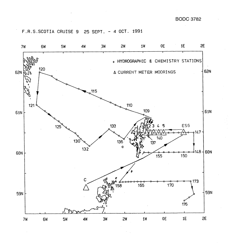
- References - including cruise tracks and cruise reports
Cruise Inventory Information
| Long name | FRV Scotia (749S) cruise 0991S_3 |
|---|---|
| Short name | 0991S_3 |
| Objectives and Narrative |
1. To deploy six current meter moorings in the northern North Sea to the east of Shetland and one current meter mooring on the NW shelf to the west of Orkney.
2. To work hydrographic stations using water bottles and CTD profilers along the Fair Isle - Munken, Faroe and the Nolso, Faroe - Flugga, Shetland sections. 3. To carry out hydrographic studies in the northern North Sea at the locations of the current meter moorings, along the JONSIS line, and along the EC lines. |
| Ship | FRV Scotia |
| Departure Port | Aberdeen, United Kingdom |
| Departure Date | 1991-09-24 |
| Arrival Port | Aberdeen, United Kingdom |
| Arrival Date | 1991-10-04 |
| Principal Scientist(s) | Eric W Henderson (Scottish Office Agriculture and Fisheries Department Aberdeen Marine Laboratory) |
| Responsible Organisation | Scottish Office Agriculture and Fisheries Department Aberdeen Marine Laboratory |
| Associated Project(s) | |
| IHB Sea Areas Visited | North Sea, North East Atlantic Ocean (limit 40W) |
| Marsden Squares Visited | 181;3/216;3/217;1/217;2/252;1 |
| Work Area Description | North Western North Sea |
| Unable to lookup cruise bounds at this time | |
| Work Area Bounding Polygon | |
| Southern Limit | unknown |
| Northern Limit | unknown |
| Western Limit | unknown |
| Eastern Limit | unknown |
Cruise Inventory Datasets
| Physical oceanography | |
|---|---|
| CTD stations |
Quantity:
number of stations =
42
Description: |
| Current meters |
Quantity:
number of stations =
6
Description: 12 ACMS deployed |
| Subsurface temperature and salinity measurements | Description: all track |
| Water bottle stations |
Quantity:
number of stations =
36
Description: |
| Chemical oceanography | |
| Nitrate |
Quantity:
number of stations =
21
Description: |
| Phosphate |
Quantity:
number of stations =
21
Description: |
| Silicate |
Quantity:
number of stations =
36
Description: |
Cruise Inventory Mooring/Buoy Operations
| Latitude | Longitude | Data type | Description |
|---|---|---|---|
| 59° 9' N | 3° 55' W | Current meters | 2 ACMS deployed 26.9.91 |
| 60° 30' N | 0° 15' W | Current meters | 2 ACMS deployed 27.9.91 |
| 60° 30' N | 0° 0' W | Current meters | 2 ACMS deployed 27.9.91 |
| 60° 30' N | 0° 30' W | Current meters | 2 ACMS deployed 27.9.91 |
| 60° 30' N | 1° 0' E | Current meters | 2 ACMS deployed 27.9.91 |
| 60° 30' N | 0° 40' W | Current meters | 2 ACMS deployed 28.9.91 |
Summary of BODC Data Holdings for the Cruise
National Oceanographic Database
Summary
| # Series | Instrument Description | Parameters |
|---|---|---|
| 32 | CTD/STD cast |
Density of the water column Electrical conductivity of the water column Salinity of the water column Temperature of the water column Vertical spatial coordinates |
Note: Parameter terms are taken from the BODC Parameter Discovery Vocabulary XML (SKOS)
Full List
| BODC Reference | Instrument Description | Date/Time | Location | |
|---|---|---|---|---|
| 411991 | CTD/STD cast | 1991-09-30 14:32Z | 60° 35' N, 2° 45' W | Click for more |
| 412005 | CTD/STD cast | 1991-09-30 15:36Z | 60° 30' N, 2° 30' W | Click for more |
| 412017 | CTD/STD cast | 1991-09-30 16:36Z | 60° 25' N, 2° 15' W | Click for more |
| 412029 | CTD/STD cast | 1991-09-30 17:35Z | 60° 19' N, 2° 0' W | Click for more |
| 412030 | CTD/STD cast | 1991-10-01 00:34Z | 60° 28' N, 0° 55' W | Click for more |
| 412042 | CTD/STD cast | 1991-10-01 01:16Z | 60° 28' N, 0° 45' W | Click for more |
| 412054 | CTD/STD cast | 1991-10-01 02:05Z | 60° 28' N, 0° 30' W | Click for more |
| 412066 | CTD/STD cast | 1991-10-01 03:03Z | 60° 28' N, 0° 15' W | Click for more |
| 412078 | CTD/STD cast | 1991-10-01 03:54Z | 60° 28' N, 0° 0' W | Click for more |
| 412091 | CTD/STD cast | 1991-10-01 04:44Z | 60° 28' N, 0° 15' E | Click for more |
| 412109 | CTD/STD cast | 1991-10-01 05:59Z | 60° 29' N, 0° 30' E | Click for more |
| 412110 | CTD/STD cast | 1991-10-01 06:58Z | 60° 29' N, 0° 45' E | Click for more |
| 412122 | CTD/STD cast | 1991-10-01 08:00Z | 60° 29' N, 1° 0' E | Click for more |
| 412134 | CTD/STD cast | 1991-10-01 09:02Z | 60° 29' N, 1° 14' E | Click for more |
| 412146 | CTD/STD cast | 1991-10-01 09:59Z | 60° 29' N, 1° 30' E | Click for more |
| 412158 | CTD/STD cast | 1991-10-01 12:54Z | 60° 0' N, 1° 30' E | Click for more |
| 412171 | CTD/STD cast | 1991-10-01 13:45Z | 60° 0' N, 1° 15' E | Click for more |
| 412183 | CTD/STD cast | 1991-10-01 14:39Z | 60° 0' N, 1° 0' E | Click for more |
| 412195 | CTD/STD cast | 1991-10-01 15:34Z | 60° 0' N, 0° 45' E | Click for more |
| 412202 | CTD/STD cast | 1991-10-01 16:28Z | 60° 0' N, 0° 30' E | Click for more |
| 412214 | CTD/STD cast | 1991-10-01 17:20Z | 60° 0' N, 0° 15' E | Click for more |
| 412226 | CTD/STD cast | 1991-10-01 18:21Z | 60° 0' N, 0° 0' E | Click for more |
| 412238 | CTD/STD cast | 1991-10-01 19:11Z | 60° 0' N, 0° 15' W | Click for more |
| 412251 | CTD/STD cast | 1991-10-01 21:22Z | 60° 0' N, 0° 46' W | Click for more |
| 412263 | CTD/STD cast | 1991-10-01 22:23Z | 60° 0' N, 1° 0' W | Click for more |
| 412275 | CTD/STD cast | 1991-10-02 16:11Z | 59° 17' N, 0° 19' E | Click for more |
| 412287 | CTD/STD cast | 1991-10-02 17:20Z | 59° 16' N, 0° 40' E | Click for more |
| 412299 | CTD/STD cast | 1991-10-02 18:31Z | 59° 16' N, 1° 0' E | Click for more |
| 412306 | CTD/STD cast | 1991-10-02 19:36Z | 59° 16' N, 1° 20' E | Click for more |
| 412318 | CTD/STD cast | 1991-10-02 21:35Z | 58° 58' N, 1° 30' E | Click for more |
| 412331 | CTD/STD cast | 1991-10-02 22:44Z | 58° 52' N, 1° 15' E | Click for more |
| 412343 | CTD/STD cast | 1991-10-03 00:01Z | 58° 48' N, 1° 0' E | Click for more |
Project Database
No data currently held for this cruise in the BODC Project Database
