BODC Cruise Metadata Report for RRS Challenger (74CH) cruise CH108B
Introduction
This report collates information from the BODC cruise inventory and oceanographic databases. It presents
- Cruise Inventory Information
- A summary of BODC data holdings for the cruise from the
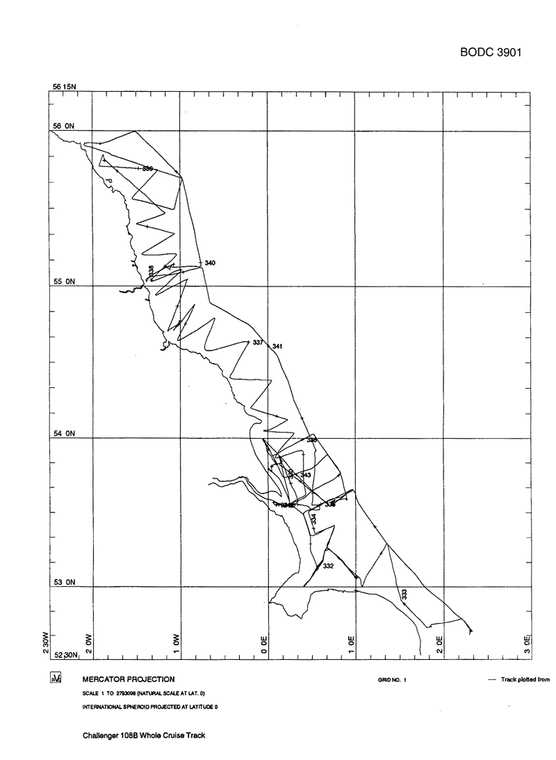
- References - including cruise tracks and cruise reports
Cruise Inventory Information
| Long name | RRS Challenger (74CH) cruise CH108B |
|---|---|
| Short name | CH108B |
| Objectives and Narrative |
1. To measure the rates of nutrient fluxes between the sediments and the water column in a variety of sediment types in the LOIS RACS-C region.
2. To map the distributions of nutrients, salinity, turbidity and Th234 in the LOIS RACS-C region. 3. To deploy (and subsequently recover) four LOIS instrument moorings to measure salinity, fluorescence, and turbidity. |
| Ship | RRS Challenger |
| Departure Port | Hull, United Kingdom |
| Departure Date | 1993-11-25 |
| Arrival Port | Hull, United Kingdom |
| Arrival Date | 1993-12-10 |
| Principal Scientist(s) | Nicholas J P Owens (Newcastle University Department of Marine Science and Coastal Management) |
| Responsible Organisation | Plymouth Marine Laboratory |
| Associated Project(s) | LOIS - RACS |
| IHB Sea Areas Visited | North Sea |
| Marsden Squares Visited | 181;1/181;3/216;1 |
| Work Area Description | Eastern North Sea coastal zone, Tweed estuary to Humber |
| Unable to lookup cruise bounds at this time | |
| Work Area Bounding Polygon | |
| Southern Limit | unknown |
| Northern Limit | unknown |
| Western Limit | unknown |
| Eastern Limit | unknown |
Cruise Inventory Datasets
| Physical oceanography | |
|---|---|
| CTD stations |
Quantity:
number of profiles =
17
Description: CTDO+transmissometer+fluorometer+PAR |
| Current meters |
Quantity:
number of stations =
4
Description: 4 deployed, 3 recovered |
| Current profiler (eg ADCP) |
Quantity:
track kilometres =
5550
Description: ADCP |
| Optics (eg underwater light levels) |
Quantity:
activity duration in days =
12
Description: thermosalinograph, continuous underway nutrients and oxygen, transmissometer, fluorometer, surface PAR |
| Optics (eg underwater light levels) |
Quantity:
number of profiles =
17
Description: CTDO+transmissometer+fluorometer+PAR |
| Sea level (inc. bot. press., inverted echosounder) |
Quantity:
number of stations =
2
Description: |
| Surface measurements underway (T,S) |
Quantity:
activity duration in days =
12
Description: thermosalinograph, continuous underway nutrients and oxygen, transmissometer, fluorometer, surface PAR |
| Transparency (eg transmissometer) | Description: Environmental monitoring package |
| Transparency (eg transmissometer) |
Quantity:
activity duration in days =
12
Description: thermosalinograph, continuous underway nutrients and oxygen, transmissometer, fluorometer, surface PAR |
| Transparency (eg transmissometer) |
Quantity:
number of profiles =
17
Description: CTDO+transmissometer+fluorometer+PAR |
| Chemical oceanography | |
| Alkalinity |
Quantity:
number of stations =
9
Description: Pore water concentration |
| Ammonia |
Quantity:
number of stations =
9
Description: Pore water fluxes and benthic fluxes |
| Isotopes |
Quantity:
number of samples =
41
Description: SAP samples for 3234Th determinations |
| Isotopes |
Quantity:
number of stations =
9
Description: for determinations of 7Be, 137Cs, 210Pb, 226Ra (sometimes 60Co) |
| Nitrate |
Quantity:
activity duration in days =
12
Description: thermosalinograph, continuous underway nutrients and oxygen, transmissometer, fluorometer, surface PAR |
| Nitrate |
Quantity:
number of stations =
9
Description: Pore water concentration and benthic flux |
| Nitrite |
Quantity:
activity duration in days =
12
Description: thermosalinograph, continuous underway nutrients and oxygen, transmissometer, fluorometer, surface PAR |
| Nitrite |
Quantity:
number of stations =
9
Description: Pore water concentrations and benthic fluxes |
| Oxygen |
Quantity:
number of profiles =
17
Description: CTDO+transmissometer+fluorometer+PAR |
| Oxygen |
Quantity:
activity duration in days =
12
Description: thermosalinograph, continuous underway nutrients and oxygen, transmissometer, fluorometer, surface PAR |
| Oxygen |
Quantity:
number of stations =
9
Description: sediment stations; range of chemical and biological measurements |
| Phosphate |
Quantity:
activity duration in days =
12
Description: thermosalinograph, continuous underway nutrients and oxygen, transmissometer, fluorometer, surface PAR |
| Phosphate |
Quantity:
number of stations =
9
Description: Pore water concentrations and fluxes |
| pH | Description: Environmental monitoring package |
| Contamination | |
| Suspended matter | Description: Environmental monitoring package |
| Biology and fisheries | |
| Phytoplankton pigs (eg chlorophyll, fluorescence) |
Quantity:
activity duration in days =
12
Description: thermosalinograph, continuous underway nutrients and oxygen, transmissometer, fluorometer, surface PAR |
| Phytoplankton pigs (eg chlorophyll, fluorescence) |
Quantity:
number of profiles =
17
Description: CTDO+transmissometer+fluorometer+PAR |
| Zoobenthos |
Quantity:
number of stations =
9
Description: |
| Geology and geophysics | |
| Single-beam echosounding |
Quantity:
track kilometres =
5550
Description: echo sounder |
Cruise Inventory Mooring/Buoy Operations
| Latitude | Longitude | Data type | Description |
|---|---|---|---|
| 53° 50' N | 0° 9' E | Current meters | S4 current meter, acoustic doppler current meter |
| 53° 48' N | 0° 0' E | Current meters | doppler, S4 current meter |
| 53° 48' N | 0° 3' E | Current meters | rig with instruments as above - deployed and recovered |
| 53° 34' N | 0° 3' E | Current meters | rig with instruments as above - deployed and recovered |
| 53° 50' N | 0° 9' E | Sea level (inc. bot. press., inverted echosounder) | transmissometer on above rig - deployed and recovered |
| 53° 48' N | 0° 0' E | Sea level (inc. bot. press., inverted echosounder) | water level recorder |
| 53° 48' N | 0° 0' E | Suspended matter | EMP 2000 Environmental Monitor |
| 53° 48' N | 0° 0' E | Transparency (eg transmissometer) | transmissometer on above rig - deployed and recovered |
| 53° 48' N | 0° 0' E | pH | EMP 2000 Environmental Monitor |
Summary of BODC Data Holdings for the Cruise
National Oceanographic Database
Summary
| # Series | Instrument Description | Parameters |
|---|---|---|
| 2 | Bottom pressure sensor tide gauge |
Date and time Sea level Temperature of the water column |
| 5 | CTD/STD cast |
Concentration of suspended particulate material in the water column Density of the water column Salinity of the water column Temperature of the water column Transmittance and attenuance of the water column Vertical spatial coordinates |
| 1 | CTD/STD cast |
Density of the water column Salinity of the water column Temperature of the water column Vertical spatial coordinates |
| 9 | CTD/STD cast |
Concentration of suspended particulate material in the water column Density of the water column Salinity of the water column Temperature of the water column Transmittance and attenuance of the water column Vertical spatial coordinates Visible waveband radiance and irradiance measurements in the water column |
| 3 | Electromagnetic current meter |
Date and time Horizontal velocity of the water column (currents) |
| 1 | Meteorological data logger |
Date and time Horizontal spatial co-ordinates Solar Radiation Visible waveband radiance and irradiance measurements in the atmosphere |
| 1 | Ship's non-toxic supply |
Chlorophyll pigment concentrations in water bodies Concentration of suspended particulate material in the water column Date and time Horizontal spatial co-ordinates Nitrate concentration parameters in the water column Nitrite concentration parameters in the water column Phosphate concentration parameters in the water column Salinity of the water column Temperature of the water column Transmittance and attenuance of the water column |
| 1 | Single-beam echosounder |
Bathymetry and Elevation Date and time Horizontal spatial co-ordinates |
| 4 | Transmissometer |
Concentration of suspended particulate material in the water column Date and time Transmittance and attenuance of the water column |
Note: Parameter terms are taken from the BODC Parameter Discovery Vocabulary XML (SKOS)
Full List
| BODC Reference | Instrument Description | Date/Time | Location | |
|---|---|---|---|---|
| 449663 | Electromagnetic current meter | 1993-11-27 16:00Z to 1993-12-08 10:04Z | 53° 33' N, 0° 3' E | Click for more |
| 449699 | Electromagnetic current meter | 1993-11-26 10:00Z to 1993-12-08 00:05Z | 53° 51' N, 0° 9' E | Click for more |
| 449718 | Electromagnetic current meter | 1993-11-26 15:00Z to 1993-12-08 01:02Z | 53° 48' N, 0° 0' E | Click for more |
| 576545 | Bottom pressure sensor tide gauge | 1993-11-26 09:10Z to 1993-12-08 15:20Z | 53° 50' N, 0° 9' E | Click for more |
| 576570 | Bottom pressure sensor tide gauge | 1993-11-26 10:50Z to 1993-12-12 10:40Z | 53° 48' N, 0° 3' E | Click for more |
| 576594 | Transmissometer | 1993-11-26 14:10Z to 1993-12-17 08:16Z | 53° 48' N, 0° 0' E | Click for more |
| 576625 | Transmissometer | 1993-11-26 10:48Z to 1993-12-12 10:39Z | 53° 48' N, 0° 3' E | Click for more |
| 576649 | Transmissometer | 1993-11-27 15:09Z to 1993-12-08 11:44Z | 53° 34' N, 0° 3' E | Click for more |
| 576662 | Transmissometer | 1993-11-26 09:25Z to 1993-12-08 15:08Z | 53° 51' N, 0° 9' E | Click for more |
| 832397 | CTD/STD cast | 1993-11-26 09:34Z | 53° 50' N, 0° 9' E | Click for more |
| 832404 | CTD/STD cast | 1993-11-26 11:08Z | 53° 48' N, 0° 2' E | Click for more |
| 832416 | CTD/STD cast | 1993-11-27 04:08Z | 53° 33' N, 0° 5' E | Click for more |
| 832428 | CTD/STD cast | 1993-11-27 14:46Z | 53° 34' N, 0° 3' E | Click for more |
| 832441 | CTD/STD cast | 1993-11-28 05:35Z | 53° 7' N, 0° 34' E | Click for more |
| 832453 | CTD/STD cast | 1993-11-29 06:23Z | 52° 42' N, 2° 18' E | Click for more |
| 832465 | CTD/STD cast | 1993-11-30 05:49Z | 53° 4' N, 1° 0' E | Click for more |
| 832477 | CTD/STD cast | 1993-12-01 05:21Z | 53° 33' N, 0° 44' E | Click for more |
| 832489 | CTD/STD cast | 1993-12-01 12:24Z | 53° 34' N, 0° 43' E | Click for more |
| 832490 | CTD/STD cast | 1993-12-01 14:57Z | 53° 35' N, 0° 53' E | Click for more |
| 832508 | CTD/STD cast | 1993-12-03 09:07Z | 54° 46' N, 1° 0' W | Click for more |
| 832521 | CTD/STD cast | 1993-12-04 13:16Z | 55° 48' N, 1° 51' W | Click for more |
| 832533 | CTD/STD cast | 1993-12-05 10:37Z | 55° 54' N, 1° 54' W | Click for more |
| 832545 | CTD/STD cast | 1993-12-05 13:14Z | 55° 55' N, 2° 4' W | Click for more |
| 832557 | CTD/STD cast | 1993-12-06 08:34Z | 55° 7' N, 1° 9' W | Click for more |
| 952001 | Single-beam echosounder | 1993-11-25 21:02Z to 1993-12-09 21:47Z | 52° 40' N to 56° 0' N; 2° 5' W to 2° 19' E | Click for more |
| 952013 | Meteorological data logger | 1993-11-25 21:02Z to 1993-12-09 21:47Z | 52° 40' N to 56° 0' N; 2° 5' W to 2° 19' E | Click for more |
| 952025 | Ship's non-toxic supply | 1993-11-25 21:02Z to 1993-12-09 21:47Z | 52° 40' N to 56° 0' N; 2° 5' W to 2° 19' E | Click for more |
Project Database
| # Events | Gear Type | Parameters Held |
|---|---|---|
| 25 | Sample taken from ship's non-toxic supply |
Concentration of suspended particulate material in the water column
|
| 1 | Stand-alone pumps | |
| 8 | Multicorer | |
| 5 | Instrument mooring | |
| 17 | CTD frame plus rosette sampler |
Transmittance and attenuance of the water column
Salinity of the water column Temperature of the water column Concentration of suspended particulate material in the water column Visible waveband radiance and irradiance measurements in the water column Density of the water column |
| 25 | Day grab | |
| 23 | Box core |
Zoobenthos taxonomic abundance
Other fluxes between the bed and the water column Redox potential in sediment Nutrient fluxes between the bed and the water column Sediment water content, porosity and surface area Metal fluxes between the bed and the water column Metadata parameters Carbon concentrations in sediment Nitrogen concentrations in sediment Sediment grain size parameters |
Note: Parameter terms are taken from the BODC Parameter Discovery Vocabulary XML (SKOS)
