BODC Cruise Metadata Report for FRV Clupea (74CU) cruise 0193C_1
Introduction
This report collates information from the BODC cruise inventory and oceanographic databases. It presents
- Cruise Inventory Information
- A summary of BODC data holdings for the cruise from the
- References - including cruise tracks and cruise reports
Cruise Inventory Information
| Long name | FRV Clupea (74CU) cruise 0193C_1 |
|---|---|
| Short name | 0193C_1 |
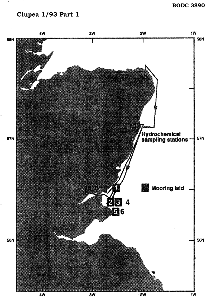
| Objectives and Narrative |
1. To lay six current meter moorings.
2. To undertake a hydrochemical survey along the east coast of Scotland, Moray Firth to the Firth of Forth. |
| Ship | FRV Clupea |
| Departure Port | Fraserburgh, United Kingdom |
| Departure Date | 1993-01-06 |
| Arrival Port | Aberdeen, United Kingdom |
| Arrival Date | 1993-01-08 |
| Principal Scientist(s) | Philip W Balls (Scottish Office Agriculture and Fisheries Department Aberdeen Marine Laboratory) |
| Responsible Organisation | Scottish Office Agriculture and Fisheries Department Aberdeen Marine Laboratory |
| Associated Project(s) | Coastal Zone Project |
| IHB Sea Areas Visited | North Sea |
| Marsden Squares Visited | 181;3 |
| Work Area Description | East coast of Scotland (Moray Firth, Firth of Forth). |
| Unable to lookup cruise bounds at this time | |
| Work Area Bounding Polygon | |
| Southern Limit | unknown |
| Northern Limit | unknown |
| Western Limit | unknown |
| Eastern Limit | unknown |
Cruise Inventory Datasets
| Physical oceanography | |
|---|---|
| CTD stations |
Quantity:
number of stations =
8
Description: |
| Current meters |
Quantity:
number of stations =
4
Description: 7 ACM deployed |
| Surface measurements underway (T,S) |
Quantity:
number of measurements =
100
Description: thermosalinograph |
| Chemical oceanography | |
| Ammonia |
Quantity:
number of stations =
7
Description: |
| Nitrate |
Quantity:
number of stations =
7
Description: |
| Phosphate |
Quantity:
number of stations =
7
Description: |
| Silicate |
Quantity:
number of stations =
7
Description: |
| Biology and fisheries | |
| Phytoplankton pigs (eg chlorophyll, fluorescence) |
Quantity:
number of stations =
8
Description: |
Cruise Inventory Mooring/Buoy Operations
| Latitude | Longitude | Data type | Description |
|---|---|---|---|
| 56° 22' N | 2° 37' W | Current meters | 1 ACM deployed 7.1.93 |
| 56° 22' N | 2° 30' W | Current meters | 2 ACM deployed 8.1.93 |
| 56° 16' N | 2° 33' W | Current meters | 2 ACM deployed 8.1.93 |
| 56° 31' N | 2° 31' W | Current meters | 2 ACM, 1 WLR deployed 7.1.93 |
| 56° 31' N | 2° 31' W | Sea level (inc. bot. press., inverted echosounder) | 2 ACM, 1 WLR deployed 7.1.93 |
Summary of BODC Data Holdings for the Cruise
National Oceanographic Database
Summary
| # Series | Instrument Description | Parameters |
|---|---|---|
| 8 | CTD/STD cast |
Density of the water column Electrical conductivity of the water column Salinity of the water column Temperature of the water column Vertical spatial coordinates |
Note: Parameter terms are taken from the BODC Parameter Discovery Vocabulary XML (SKOS)
Full List
| BODC Reference | Instrument Description | Date/Time | Location | |
|---|---|---|---|---|
| 403247 | CTD/STD cast | 1993-01-06 19:10Z | 57° 7' N, 1° 52' W | Click for more |
| 403259 | CTD/STD cast | 1993-01-06 20:10Z | 57° 7' N, 1° 54' W | Click for more |
| 403260 | CTD/STD cast | 1993-01-06 20:34Z | 57° 7' N, 1° 56' W | Click for more |
| 403272 | CTD/STD cast | 1993-01-06 20:53Z | 57° 7' N, 1° 58' W | Click for more |
| 403284 | CTD/STD cast | 1993-01-06 21:11Z | 57° 7' N, 2° 0' W | Click for more |
| 403296 | CTD/STD cast | 1993-01-06 21:23Z | 57° 7' N, 2° 1' W | Click for more |
| 403303 | CTD/STD cast | 1993-01-06 21:33Z | 57° 7' N, 2° 1' W | Click for more |
| 403315 | CTD/STD cast | 1993-01-07 15:20Z | 56° 27' N, 2° 45' W | Click for more |
Project Database
No data currently held for this cruise in the BODC Project Database
