BODC Cruise Metadata Report for FRV Clupea (74CU) cruise 1094C
Introduction
This report collates information from the BODC cruise inventory and oceanographic databases. It presents
- Cruise Inventory Information
- A summary of BODC data holdings for the cruise from the
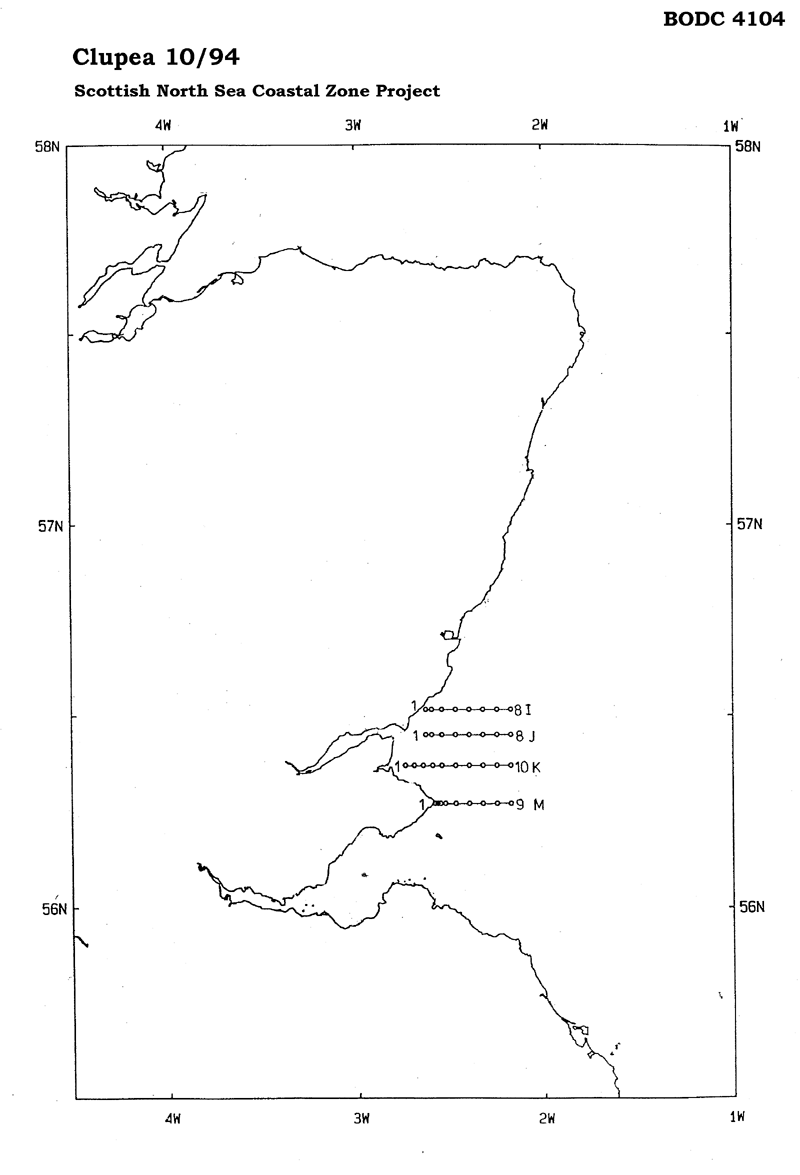
- References - including cruise tracks and cruise reports
Cruise Inventory Information
| Long name | FRV Clupea (74CU) cruise 1094C |
|---|---|
| Short name | 1094C |
| Objectives and Narrative |
1. To service two oceanographic buoy moorings off St. Andrews in the Scottish coastal zone.
2. To carry out a CTD and water bottle survey on four lines of stations in the Scottish coastal zone between Arbroath and Fife Ness to establish the temperature and salinity patterns and the nutrient concentrations in the area. |
| Ship | FRV Clupea |
| Departure Port | Fraserburgh, United Kingdom |
| Departure Date | 1994-05-16 |
| Arrival Port | Fraserburgh, United Kingdom |
| Arrival Date | 1994-05-19 |
| Principal Scientist(s) | Rodney Payne (Scottish Office Agriculture Environment and Fisheries Department Aberdeen Marine Laboratory) |
| Responsible Organisation | Scottish Office Agriculture Environment and Fisheries Department Aberdeen Marine Laboratory |
| Associated Project(s) | |
| IHB Sea Areas Visited | North Sea |
| Marsden Squares Visited | 181;3 |
| Work Area Description | St Andrews Bay |
| Unable to lookup cruise bounds at this time | |
| Work Area Bounding Polygon | |
| Southern Limit | unknown |
| Northern Limit | unknown |
| Western Limit | unknown |
| Eastern Limit | unknown |
Cruise Inventory Datasets
| Physical oceanography | |
|---|---|
| CTD stations |
Quantity:
number of stations =
26
Description: CTD and Rosette with Fluorometer |
| Current meters |
Quantity:
number of stations =
2
Description: recovered & deployed |
| Chemical oceanography | |
| Nitrate |
Quantity:
number of stations =
26
Description: |
| Phosphate |
Quantity:
number of stations =
26
Description: |
| Silicate |
Quantity:
number of stations =
26
Description: |
| Biology and fisheries | |
| Phytoplankton pigs (eg chlorophyll, fluorescence) |
Quantity:
number of stations =
25
Description: |
| Phytoplankton pigs (eg chlorophyll, fluorescence) |
Quantity:
number of stations =
26
Description: CTD and Rosette with Fluorometer |
Cruise Inventory Mooring/Buoy Operations
| Latitude | Longitude | Data type | Description |
|---|---|---|---|
| 56° 22' N | 2° 37' W | Current meters | 1 ACM, 1 WLR, 1 Nutrient Analyser recovered and deployed 17 May 1994 |
| 56° 22' N | 2° 18' W | Current meters | 2 ACM, 1 WLR, 1 Nutrient Analyser recovered and deployed 17 May 1994 |
| 56° 22' N | 2° 37' W | Other physical oceanographic measurements | 1 ACM, 1 WLR, 1 Nutrient Analyser recovered and deployed 17 May 1994 |
| 56° 22' N | 2° 18' W | Other physical oceanographic measurements | 2 ACM, 1 WLR, 1 Nutrient Analyser recovered and deployed 17 May 1994 |
| 56° 22' N | 2° 37' W | Sea level (inc. bot. press., inverted echosounder) | 1 ACM, 1 WLR, 1 Nutrient Analyser recovered and deployed 17 May 1994 |
| 56° 22' N | 2° 18' W | Sea level (inc. bot. press., inverted echosounder) | 2 ACM, 1 WLR, 1 Nutrient Analyser recovered and deployed 17 May 1994 |
Summary of BODC Data Holdings for the Cruise
National Oceanographic Database
Summary
| # Series | Instrument Description | Parameters |
|---|---|---|
| 26 | CTD/STD cast |
Density of the water column Electrical conductivity of the water column Salinity of the water column Temperature of the water column Vertical spatial coordinates |
Note: Parameter terms are taken from the BODC Parameter Discovery Vocabulary XML (SKOS)
Full List
| BODC Reference | Instrument Description | Date/Time | Location | |
|---|---|---|---|---|
| 397511 | CTD/STD cast | 1994-05-17 11:36Z | 56° 22' N, 2° 19' W | Click for more |
| 397523 | CTD/STD cast | 1994-05-17 12:13Z | 56° 22' N, 2° 23' W | Click for more |
| 397535 | CTD/STD cast | 1994-05-17 12:46Z | 56° 22' N, 2° 28' W | Click for more |
| 397547 | CTD/STD cast | 1994-05-17 13:25Z | 56° 22' N, 2° 32' W | Click for more |
| 397559 | CTD/STD cast | 1994-05-17 13:51Z | 56° 22' N, 2° 35' W | Click for more |
| 397560 | CTD/STD cast | 1994-05-17 14:13Z | 56° 22' N, 2° 38' W | Click for more |
| 397572 | CTD/STD cast | 1994-05-17 14:35Z | 56° 22' N, 2° 41' W | Click for more |
| 397584 | CTD/STD cast | 1994-05-17 14:59Z | 56° 22' N, 2° 44' W | Click for more |
| 397596 | CTD/STD cast | 1994-05-17 16:13Z | 56° 16' N, 2° 34' W | Click for more |
| 397603 | CTD/STD cast | 1994-05-17 16:33Z | 56° 16' N, 2° 33' W | Click for more |
| 397615 | CTD/STD cast | 1994-05-17 16:48Z | 56° 16' N, 2° 33' W | Click for more |
| 397627 | CTD/STD cast | 1994-05-17 17:09Z | 56° 16' N, 2° 31' W | Click for more |
| 397639 | CTD/STD cast | 1994-05-17 17:38Z | 56° 16' N, 2° 27' W | Click for more |
| 397640 | CTD/STD cast | 1994-05-17 18:19Z | 56° 16' N, 2° 24' W | Click for more |
| 397652 | CTD/STD cast | 1994-05-18 09:56Z | 56° 27' N, 2° 19' W | Click for more |
| 397664 | CTD/STD cast | 1994-05-18 10:21Z | 56° 27' N, 2° 23' W | Click for more |
| 397676 | CTD/STD cast | 1994-05-18 11:11Z | 56° 27' N, 2° 27' W | Click for more |
| 397688 | CTD/STD cast | 1994-05-18 11:39Z | 56° 27' N, 2° 32' W | Click for more |
| 397707 | CTD/STD cast | 1994-05-18 11:59Z | 56° 27' N, 2° 36' W | Click for more |
| 397719 | CTD/STD cast | 1994-05-18 12:13Z | 56° 27' N, 2° 37' W | Click for more |
| 397720 | CTD/STD cast | 1994-05-18 12:46Z | 56° 31' N, 2° 37' W | Click for more |
| 397732 | CTD/STD cast | 1994-05-18 13:03Z | 56° 31' N, 2° 36' W | Click for more |
| 397744 | CTD/STD cast | 1994-05-18 13:26Z | 56° 31' N, 2° 32' W | Click for more |
| 397756 | CTD/STD cast | 1994-05-18 13:54Z | 56° 31' N, 2° 28' W | Click for more |
| 397768 | CTD/STD cast | 1994-05-18 14:26Z | 56° 31' N, 2° 23' W | Click for more |
| 397781 | CTD/STD cast | 1994-05-18 14:56Z | 56° 31' N, 2° 19' W | Click for more |
Project Database
No data currently held for this cruise in the BODC Project Database
