BODC Cruise Metadata Report for FRV Scotia (749S) cruise 0594S
Introduction
This report collates information from the BODC cruise inventory and oceanographic databases. It presents
- Cruise Inventory Information
- A summary of BODC data holdings for the cruise from the
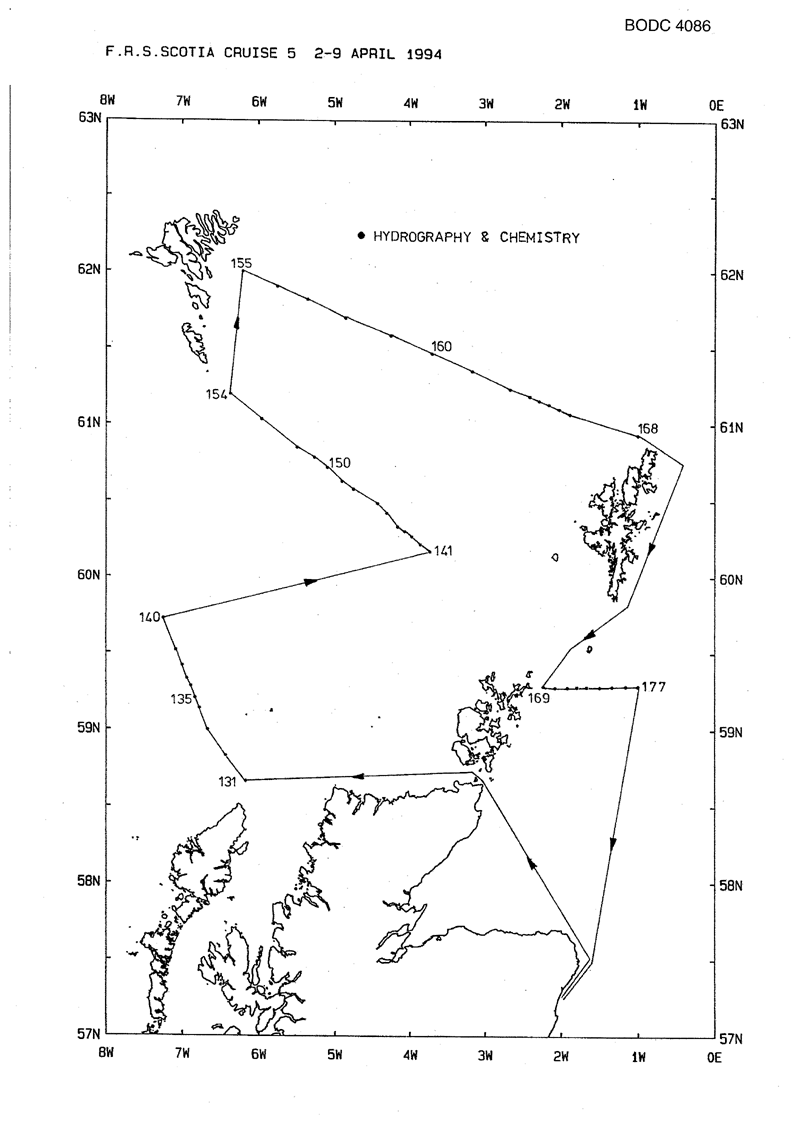
- References - including cruise tracks and cruise reports
Cruise Inventory Information
| Long name | FRV Scotia (749S) cruise 0594S |
|---|---|
| Short name | 0594S |
| Objectives and Narrative |
1. To perform hydrographic surveys along the Fair Isle - Munken (Faroe) [SEFOS standard section 19] and Nolso (Faroe) - Flugga (Shetland) [SEFOS standard section 18] standard sections.
2. To perform hydrographic surveys along the Faroe Bank - Butt of Lewis [SEFOS standard section 17] standard section. 3. To survey the standard JONSIS, East Shetland (ES) [SEFOS standard section 20] and northern North Sea (EC) sections. 4. Collect the Fair Isle radio-caesium samples for analysis by MAFF, Lowestoft. |
| Ship | FRV Scotia |
| Departure Port | Aberdeen, United Kingdom |
| Departure Date | 1994-04-02 |
| Arrival Port | Aberdeen, United Kingdom |
| Arrival Date | 1994-04-09 |
| Principal Scientist(s) | Bill Turrell (Scottish Office Agriculture Environment and Fisheries Department Aberdeen Marine Laboratory) |
| Responsible Organisation | Scottish Office Agriculture Environment and Fisheries Department Aberdeen Marine Laboratory |
| Associated Project(s) | Part SEFOS/EC |
| IHB Sea Areas Visited | North Sea, North East Atlantic Ocean (limit 40W) |
| Marsden Squares Visited | 181;3/181;4/217;1/217;2 |
| Work Area Description | Faroes, Shetland, Butt of Lewis and northern North Sea |
| Unable to lookup cruise bounds at this time | |
| Work Area Bounding Polygon | |
| Southern Limit | unknown |
| Northern Limit | unknown |
| Western Limit | unknown |
| Eastern Limit | unknown |
Cruise Inventory Datasets
| Physical oceanography | |
|---|---|
| CTD stations |
Quantity:
number of stations =
5
Description: Seabird CTD with bottle above for calibration. |
| Current profiler (eg ADCP) |
Quantity:
track kilometres =
1861
Description: RDI ADCP |
| Surface measurements underway (T,S) |
Quantity:
track kilometres =
1861
Description: Thermosalinograph |
| Water bottle stations |
Quantity:
number of stations =
42
Description: |
| Chemical oceanography | |
| Nitrate |
Quantity:
number of stations =
9
Description: |
| Phosphate |
Quantity:
number of stations =
9
Description: |
| Silicate |
Quantity:
number of stations =
9
Description: |
Cruise Inventory Mooring/Buoy Operations
No information on datasets is currently available
Summary of BODC Data Holdings for the Cruise
National Oceanographic Database
Summary
| # Series | Instrument Description | Parameters |
|---|---|---|
| 5 | CTD/STD cast |
Density of the water column Dissolved oxygen parameters in the water column Electrical conductivity of the water column Salinity of the water column Temperature of the water column Transmittance and attenuance of the water column Vertical spatial coordinates |
Note: Parameter terms are taken from the BODC Parameter Discovery Vocabulary XML (SKOS)
Full List
| BODC Reference | Instrument Description | Date/Time | Location | |
|---|---|---|---|---|
| 421567 | CTD/STD cast | 1994-04-03 19:31Z | 58° 40' N, 6° 10' W | Click for more |
| 421579 | CTD/STD cast | 1994-04-03 21:11Z | 58° 49' N, 6° 25' W | Click for more |
| 421580 | CTD/STD cast | 1994-04-03 22:52Z | 59° 0' N, 6° 40' W | Click for more |
| 421592 | CTD/STD cast | 1994-04-04 00:25Z | 59° 8' N, 6° 46' W | Click for more |
| 421611 | CTD/STD cast | 1994-04-04 01:29Z | 59° 12' N, 6° 49' W | Click for more |
Project Database
No data currently held for this cruise in the BODC Project Database
