BODC Cruise Metadata Report for RRS Challenger (74CH) cruise CH117B
Introduction
This report collates information from the BODC cruise inventory and oceanographic databases. It presents
- Cruise Inventory Information
- A summary of BODC data holdings for the cruise from the
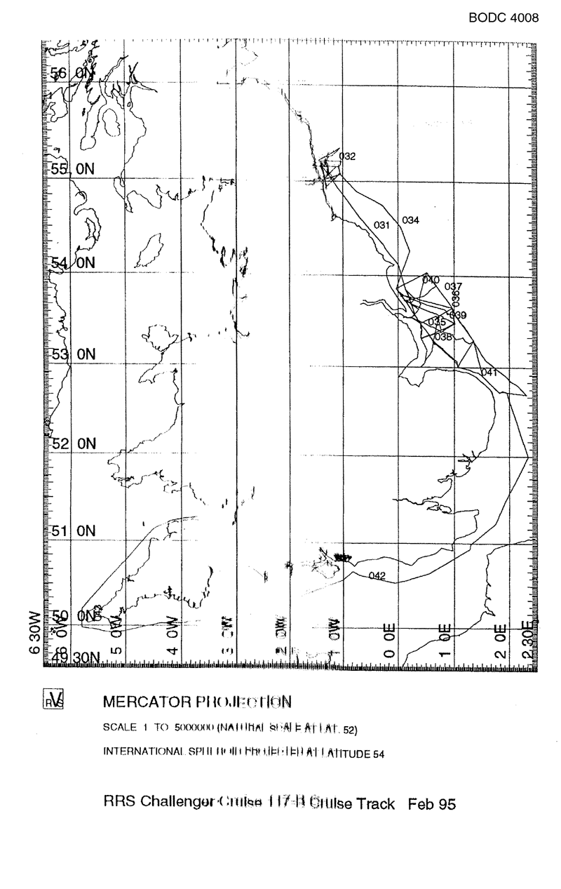
- References - including cruise tracks and cruise reports
Cruise Inventory Information
| Long name | RRS Challenger (74CH) cruise CH117B |
|---|---|
| Short name | CH117B |
| Objectives and Narrative |
1. To quantify the rates and processes of sediment-water exchange of nutrients, trace metals and oxygen in the sediments of the Humber/Wash and Tyne regions.
2. To quantify pore water concentration gradients of nutrients and trace metals, the distributions of naturally occurring radionuclides, and the rates of dentrification/nitrification and sulphate reduction within the surficial zone of these sediments. 3. To determine the population density of bioturbating macrofauna within these sediments. 4. To map the distribution of dissolved nutrients, salinity, temperature, turbidity and fluorescence in the LOIS RACS (C) region. 5. To deploy and recover one experiment mooring rig to measure currents, and recover six previously deployed instrument mooring rigs. 6. To characterise organic micropollutant geochemistry in the waters, suspended particulate and sediments of the Humber/Wash region. |
| Ship | RRS Challenger |
| Departure Port | Grimsby, United Kingdom |
| Departure Date | 1995-01-30 |
| Arrival Port | Barry, United Kingdom |
| Arrival Date | 1995-02-13 |
| Principal Scientist(s) | Peter G Watson (Plymouth Marine Laboratory) |
| Responsible Organisation | Plymouth Marine Laboratory |
| Associated Project(s) | LOIS - RACS |
| IHB Sea Areas Visited | English Channel, North Sea, Bristol Channel |
| Marsden Squares Visited | 181;1/181;2/181;3/216;1 |
| Work Area Description | Bristol Channel, English Channel and North Sea, coastal strip between the Great Yarmouth and Berwick upon Tweed |
| Unable to lookup cruise bounds at this time | |
| Work Area Bounding Polygon | |
| Southern Limit | unknown |
| Northern Limit | unknown |
| Western Limit | unknown |
| Eastern Limit | unknown |
Cruise Inventory Datasets
| Physical oceanography | |
|---|---|
| CTD stations |
Quantity:
number of profiles =
19
Description: Neil Brown MK IIIB CTD |
| Current meters |
Quantity:
number of recoveries =
6
Description: 5 recovered & 1 deployed & recovered |
| Current profiler (eg ADCP) |
Quantity:
track kilometres =
1611
Description: shipborne ADCP |
| Optics (eg underwater light levels) |
Quantity:
number of profiles =
19
Description: up and downwelling 2pi PAR padiance meters attached to CTD |
| Surface measurements underway (T,S) |
Quantity:
track kilometres =
1611
Description: |
| Transparency (eg transmissometer) |
Quantity:
track kilometres =
1611
Description: |
| Transparency (eg transmissometer) |
Quantity:
number of profiles =
19
Description: 25cm transmissometer attached to CTD |
| Chemical oceanography | |
| Ammonia |
Quantity:
number of experiments =
14
Description: exchanges/metals in sediment-water interface/pore water |
| Nitrate |
Quantity:
number of experiments =
14
Description: exchanges/metals in sediment-water interface/pore water |
| Nitrate |
Quantity:
track kilometres =
1611
Description: surface underway measurements |
| Nitrite |
Quantity:
number of experiments =
14
Description: exchanges/metals in sediment-water interface/pore water |
| Nitrite |
Quantity:
track kilometres =
1611
Description: surface underway measurements |
| Other chemical oceanographic measurements |
Quantity:
number of cores =
8
Description: Eh, oxygen profiles and resistivity in sediments |
| Other chemical oceanographic measurements |
Quantity:
number of cores =
60
Description: nitrification/denitrification studies on sediment cores |
| Other chemical oceanographic measurements |
Quantity:
number of cores =
6
Description: sulphate reduction studies in sediments |
| Other chemical oceanographic measurements |
Quantity:
number of cores =
14
Description: Eh, porosity, particle size distribution of sediment cores |
| Oxygen |
Quantity:
number of profiles =
19
Description: dissolved oxygen sensor attached to CTD |
| Oxygen |
Quantity:
number of cores =
21
Description: oxygen consumption in sediments |
| Oxygen |
Quantity:
number of cores =
8
Description: Eh, oxygen profiles and resistivity in sediments |
| Phosphate |
Quantity:
track kilometres =
1611
Description: surface underway measurements |
| Phosphate |
Quantity:
number of experiments =
14
Description: exchanges/metals in sediment-water interface/pore water |
| Radioactivity |
Quantity:
number of cores =
6
Description: surface scrapes and sectional cores for radioisotopes in sediments |
| Silicate |
Quantity:
number of experiments =
14
Description: exchanges/metals in sediment-water interface/pore water |
| Silicate |
Quantity:
track kilometres =
1611
Description: surface underway measurements |
| Contamination | |
| Other dissolved substances |
Quantity:
number of samples =
21
Description: SPM by weight,POC,susp. Particulate, dissolved micro-pollutant analysis. |
| Suspended matter |
Quantity:
number of samples =
21
Description: SPM by weight,POC,susp. particulate, dissolved micro-pollutant analysis. |
| Suspended matter |
Quantity:
number of samples =
27
Description: gravimetric SPM/extracted chl. determ. from rosette/non-toxic |
| Trace metals |
Quantity:
number of experiments =
14
Description: exchanges/metals in sediment-water interface/pore water |
| Trace metals |
Quantity:
number of samples =
27
Description: gravimetric SPM/extracted chl. determ. from rosette/non-toxic |
| Biology and fisheries | |
| Benthic bacteria/micro-organisms |
Quantity:
number of cores =
28
Description: |
| Particulate organic matter (inc POC, PON) |
Quantity:
number of samples =
21
Description: SPM by weight,POC,susp. particulate, dissolved micro-pollutant analysis. |
| Phytoplankton pigs (eg chlorophyll, fluorescence) |
Quantity:
number of profiles =
19
Description: fluorometer attached to CTD |
| Phytoplankton pigs (eg chlorophyll, fluorescence) |
Quantity:
track kilometres =
1611
Description: fluorescence |
| Meteorology | |
| Incident radiation |
Quantity:
track kilometres =
1611
Description: incident PAR, solar radiation |
| Geology and geophysics | |
| Core - soft bottom |
Quantity:
number of cores =
14
Description: Eh, porosity, particle size distribution of sediment cores |
Cruise Inventory Mooring/Buoy Operations
| Latitude | Longitude | Data type | Description |
|---|---|---|---|
| 53° 48' N | 0° 3' E | Current meters | Station N2 deployed 8 Feb 95, recovered 9 Feb 95 |
| 53° 48' N | 0° 3' E | Current meters | Station N2, recovered 9 Feb 95 |
| 53° 51' N | 0° 10' E | Current meters | Station N3, recovered 7 Feb 95 |
| 53° 43' N | 0° 4' E | Current meters | Station S1 recovered 7 Feb 95 from Janet M |
| 53° 43' N | 0° 7' E | Current meters | Station S2, recovered 7 Feb 95 |
| 53° 46' N | 0° 13' E | Current meters | Station S3, recovered 7 Feb 95 |
| 53° 46' N | 0° 0' E | Current profiler (eg ADCP) | Station N1; recovered 7 Feb 95 from fishing vessel Janet M |
| 53° 48' N | 0° 3' E | Current profiler (eg ADCP) | Station N2, recovered 9 Feb 95 |
| 53° 51' N | 0° 10' E | Current profiler (eg ADCP) | Station N3, recovered 7 Feb 95 |
| 53° 43' N | 0° 4' E | Current profiler (eg ADCP) | Station S1 recovered 7 Feb 95 from Janet M |
| 53° 43' N | 0° 7' E | Current profiler (eg ADCP) | Station S2, recovered 7 Feb 95 |
| 53° 46' N | 0° 13' E | Current profiler (eg ADCP) | Station S3, recovered 7 Feb 95 |
| 53° 46' N | 0° 0' E | Instrumented wave measurements | Station N1; recovered 7 Feb 95 from fishing vessel Janet M |
| 53° 48' N | 0° 3' E | Instrumented wave measurements | Station N2 deployed 8 Feb 95, recovered 9 Feb 95 |
| 53° 48' N | 0° 3' E | Instrumented wave measurements | Station N2, recovered 9 Feb 95 |
| 53° 51' N | 0° 10' E | Instrumented wave measurements | Station N3, recovered 7 Feb 95 |
| 53° 46' N | 0° 13' E | Instrumented wave measurements | Station S3, recovered 7 Feb 95 |
| 53° 46' N | 0° 0' E | Other physical oceanographic measurements | Station N1; recovered 7 Feb 95 from fishing vessel Janet M |
| 53° 48' N | 0° 3' E | Other physical oceanographic measurements | Station N2, recovered 9 Feb 95 |
| 53° 43' N | 0° 4' E | Other physical oceanographic measurements | Station S1 recovered 7 Feb 95 from Janet M |
| 53° 43' N | 0° 7' E | Other physical oceanographic measurements | Station S2, recovered 7 Feb 95 |
| 53° 51' N | 0° 10' E | Routine standard measurements | Station N3, recovered 7 Feb 95 |
| 53° 46' N | 0° 0' E | Sea level (inc. bot. press., inverted echosounder) | Station N1; recovered 7 Feb 95 from fishing vessel Janet M |
| 53° 48' N | 0° 3' E | Sea level (inc. bot. press., inverted echosounder) | Station N2 deployed 8 Feb 95, recovered 9 Feb 95 |
| 53° 48' N | 0° 3' E | Sea level (inc. bot. press., inverted echosounder) | Station N2, recovered 9 Feb 95 |
| 53° 51' N | 0° 10' E | Sea level (inc. bot. press., inverted echosounder) | Station N3, recovered 7 Feb 95 |
| 53° 43' N | 0° 4' E | Sea level (inc. bot. press., inverted echosounder) | Station S1 recovered 7 Feb 95 from Janet M |
| 53° 43' N | 0° 7' E | Sea level (inc. bot. press., inverted echosounder) | Station S2, recovered 7 Feb 95 |
| 53° 46' N | 0° 13' E | Sea level (inc. bot. press., inverted echosounder) | Station S3, recovered 7 Feb 95 |
| 53° 46' N | 0° 0' E | Transparency (eg transmissometer) | Station N1; recovered 7 Feb 95 from fishing vessel Janet M |
| 53° 48' N | 0° 3' E | Transparency (eg transmissometer) | Station N2, recovered 9 Feb 95 |
| 53° 51' N | 0° 10' E | Transparency (eg transmissometer) | Station N3, recovered 7 Feb 95 |
| 53° 43' N | 0° 4' E | Transparency (eg transmissometer) | Station S1 recovered 7 Feb 95 from Janet M |
| 53° 43' N | 0° 7' E | Transparency (eg transmissometer) | Station S2, recovered 7 Feb 95 |
| 53° 46' N | 0° 13' E | Transparency (eg transmissometer) | Station S3, recovered 7 Feb 95 |
| 53° 48' N | 0° 3' E | pH | Station N2, recovered 9 Feb 95 |
| 53° 43' N | 0° 7' E | pH | Station S2, recovered 7 Feb 95 |
Summary of BODC Data Holdings for the Cruise
National Oceanographic Database
Summary
| # Series | Instrument Description | Parameters |
|---|---|---|
| 12 | Bottle station |
Chlorophyll pigment concentrations in water bodies Phaeopigment concentrations in the water column Quality control flags Reference numbers Vertical spatial coordinates |
| 19 | Bottle station |
Chlorophyll pigment concentrations in water bodies Quality control flags Reference numbers Vertical spatial coordinates |
| 18 | Bottle station |
Quality control flags Reference numbers Salinity of the water column Temperature of the water column Vertical spatial coordinates |
| 16 | CTD/STD cast |
Chlorophyll pigment concentrations in water bodies Concentration of suspended particulate material in the water column Density of the water column Salinity of the water column Temperature of the water column Transmittance and attenuance of the water column Vertical spatial coordinates Visible waveband radiance and irradiance measurements in the water column |
| 1 | CTD/STD cast |
Chlorophyll pigment concentrations in water bodies Density of the water column Salinity of the water column Temperature of the water column Vertical spatial coordinates Visible waveband radiance and irradiance measurements in the water column |
| 2 | CTD/STD cast |
Chlorophyll pigment concentrations in water bodies Concentration of suspended particulate material in the water column Density of the water column Salinity of the water column Temperature of the water column Transmittance and attenuance of the water column Vertical spatial coordinates |
| 1 | Meteorological data logger |
Date and time Horizontal spatial co-ordinates Solar Radiation Visible waveband radiance and irradiance measurements in the atmosphere |
| 1 | Pumped water sample |
Chlorophyll pigment concentrations in water bodies Date and time Horizontal spatial co-ordinates Phaeopigment concentrations in the water column |
| 1 | Ship's non-toxic supply |
Chlorophyll pigment concentrations in water bodies Concentration of suspended particulate material in the water column Date and time Horizontal spatial co-ordinates Nitrate concentration parameters in the water column Nitrite concentration parameters in the water column Phosphate concentration parameters in the water column Salinity of the water column Temperature of the water column Transmittance and attenuance of the water column |
| 1 | Single-beam echosounder |
Bathymetry and Elevation Date and time Horizontal spatial co-ordinates |
Note: Parameter terms are taken from the BODC Parameter Discovery Vocabulary XML (SKOS)
Full List
| BODC Reference | Instrument Description | Date/Time | Location | |
|---|---|---|---|---|
| 838080 | CTD/STD cast | 1995-01-31 15:42Z | 55° 4' N, 1° 3' W | Click for more |
| 838092 | CTD/STD cast | 1995-01-31 18:56Z | 55° 12' N, 1° 1' W | Click for more |
| 838111 | CTD/STD cast | 1995-01-31 22:27Z | 55° 20' N, 1° 3' W | Click for more |
| 838123 | CTD/STD cast | 1995-02-01 08:22Z | 55° 9' N, 1° 24' W | Click for more |
| 838135 | CTD/STD cast | 1995-02-02 17:27Z | 55° 9' N, 1° 5' W | Click for more |
| 838147 | CTD/STD cast | 1995-02-03 16:56Z | 53° 4' N, 1° 0' E | Click for more |
| 838159 | CTD/STD cast | 1995-02-04 13:05Z | 52° 41' N, 2° 18' E | Click for more |
| 838160 | CTD/STD cast | 1995-02-04 18:57Z | 52° 54' N, 1° 30' E | Click for more |
| 838172 | CTD/STD cast | 1995-02-04 21:37Z | 53° 17' N, 1° 21' E | Click for more |
| 838184 | CTD/STD cast | 1995-02-06 01:07Z | 54° 1' N, 0° 31' E | Click for more |
| 838196 | CTD/STD cast | 1995-02-06 22:22Z | 53° 28' N, 0° 24' E | Click for more |
| 838203 | CTD/STD cast | 1995-02-06 23:30Z | 53° 19' N, 0° 25' E | Click for more |
| 838215 | CTD/STD cast | 1995-02-01 20:15Z | 55° 9' N, 1° 17' W | Click for more |
| 838227 | CTD/STD cast | 1995-02-04 17:28Z | 52° 43' N, 1° 48' E | Click for more |
| 838239 | CTD/STD cast | 1995-02-05 17:36Z | 53° 32' N, 0° 43' E | Click for more |
| 838240 | CTD/STD cast | 1995-02-06 15:40Z | 53° 33' N, 0° 6' E | Click for more |
| 838252 | CTD/STD cast | 1995-02-09 22:33Z | 53° 0' N, 1° 3' E | Click for more |
| 838264 | CTD/STD cast | 1995-02-05 20:09Z | 53° 28' N, 1° 0' E | Click for more |
| 838276 | CTD/STD cast | 1995-02-05 23:52Z | 53° 53' N, 0° 41' E | Click for more |
| 952295 | Single-beam echosounder | 1995-01-30 17:43Z to 1995-02-12 13:42Z | 49° 55' N to 55° 20' N; 5° 48' W to 2° 19' E | Click for more |
| 952302 | Meteorological data logger | 1995-01-30 17:43Z to 1995-02-12 13:42Z | 49° 55' N to 55° 20' N; 5° 48' W to 2° 19' E | Click for more |
| 952314 | Ship's non-toxic supply | 1995-01-30 17:43Z to 1995-02-12 13:42Z | 49° 55' N to 55° 20' N; 5° 48' W to 2° 19' E | Click for more |
| 1652081 | Pumped water sample | 1995-01-31 17:07Z to 1995-02-05 18:51Z | 53° 0' N to 55° 12' N; 1° 27' W to 1° 21' E | Click for more |
| 1680278 | Bottle station | 1995-01-31 15:48Z | 55° 4' N, 1° 3' W | Click for more |
| 1680291 | Bottle station | 1995-02-04 19:00Z | 52° 54' N, 1° 30' E | Click for more |
| 1680309 | Bottle station | 1995-02-04 21:40Z | 53° 17' N, 1° 21' E | Click for more |
| 1680310 | Bottle station | 1995-02-05 20:11Z | 53° 28' N, 1° 0' E | Click for more |
| 1680322 | Bottle station | 1995-02-05 23:58Z | 53° 53' N, 0° 41' E | Click for more |
| 1680334 | Bottle station | 1995-02-06 01:13Z | 54° 1' N, 0° 31' E | Click for more |
| 1680346 | Bottle station | 1995-02-06 22:24Z | 53° 28' N, 0° 24' E | Click for more |
| 1680358 | Bottle station | 1995-02-06 23:33Z | 53° 19' N, 0° 25' E | Click for more |
| 1680371 | Bottle station | 1995-02-09 22:41Z | 53° 0' N, 1° 3' E | Click for more |
| 1680383 | Bottle station | 1995-01-31 19:01Z | 55° 12' N, 1° 1' W | Click for more |
| 1680395 | Bottle station | 1995-01-31 22:31Z | 55° 20' N, 1° 3' W | Click for more |
| 1680402 | Bottle station | 1995-02-04 17:31Z | 52° 43' N, 1° 48' E | Click for more |
| 2257447 | Bottle station | 1995-01-31 15:48Z | 55° 4' N, 1° 3' W | Click for more |
| 2257459 | Bottle station | 1995-02-04 19:00Z | 52° 54' N, 1° 30' E | Click for more |
| 2257460 | Bottle station | 1995-02-04 21:39Z | 53° 17' N, 1° 21' E | Click for more |
| 2257472 | Bottle station | 1995-02-05 17:40Z | 53° 32' N, 0° 43' E | Click for more |
| 2257484 | Bottle station | 1995-02-05 20:11Z | 53° 28' N, 1° 0' E | Click for more |
| 2257496 | Bottle station | 1995-02-05 23:57Z | 53° 53' N, 0° 41' E | Click for more |
| 2257503 | Bottle station | 1995-02-06 01:12Z | 54° 1' N, 0° 31' E | Click for more |
| 2257515 | Bottle station | 1995-02-06 15:40Z | 53° 33' N, 0° 6' E | Click for more |
| 2257527 | Bottle station | 1995-02-06 22:23Z | 53° 28' N, 0° 24' E | Click for more |
| 2257539 | Bottle station | 1995-02-09 22:40Z | 53° 0' N, 1° 3' E | Click for more |
| 2257540 | Bottle station | 1995-01-31 19:01Z | 55° 12' N, 1° 1' W | Click for more |
| 2257552 | Bottle station | 1995-01-31 22:31Z | 55° 20' N, 1° 3' W | Click for more |
| 2257564 | Bottle station | 1995-02-01 08:20Z | 55° 9' N, 1° 24' W | Click for more |
| 2257576 | Bottle station | 1995-02-01 20:18Z | 55° 9' N, 1° 17' W | Click for more |
| 2257588 | Bottle station | 1995-02-02 17:34Z | 55° 9' N, 1° 5' W | Click for more |
| 2257607 | Bottle station | 1995-02-03 16:58Z | 53° 4' N, 1° 0' E | Click for more |
| 2257619 | Bottle station | 1995-02-04 13:09Z | 52° 41' N, 2° 18' E | Click for more |
| 2257620 | Bottle station | 1995-02-04 17:31Z | 52° 43' N, 1° 48' E | Click for more |
| 2260431 | Bottle station | 1995-01-31 15:48Z | 55° 4' N, 1° 3' W | Click for more |
| 2260443 | Bottle station | 1995-02-04 19:00Z | 52° 54' N, 1° 30' E | Click for more |
| 2260455 | Bottle station | 1995-02-04 21:39Z | 53° 17' N, 1° 21' E | Click for more |
| 2260467 | Bottle station | 1995-02-05 17:40Z | 53° 32' N, 0° 43' E | Click for more |
| 2260479 | Bottle station | 1995-02-05 20:11Z | 53° 28' N, 1° 0' E | Click for more |
| 2260480 | Bottle station | 1995-02-05 23:57Z | 53° 53' N, 0° 41' E | Click for more |
| 2260492 | Bottle station | 1995-02-06 01:12Z | 54° 1' N, 0° 31' E | Click for more |
| 2260511 | Bottle station | 1995-02-06 15:40Z | 53° 33' N, 0° 6' E | Click for more |
| 2260523 | Bottle station | 1995-02-06 22:23Z | 53° 28' N, 0° 24' E | Click for more |
| 2260535 | Bottle station | 1995-02-06 23:33Z | 53° 19' N, 0° 25' E | Click for more |
| 2260547 | Bottle station | 1995-02-09 22:40Z | 53° 0' N, 1° 3' E | Click for more |
| 2260559 | Bottle station | 1995-01-31 19:01Z | 55° 12' N, 1° 1' W | Click for more |
| 2260560 | Bottle station | 1995-01-31 22:31Z | 55° 20' N, 1° 3' W | Click for more |
| 2260572 | Bottle station | 1995-02-01 08:20Z | 55° 9' N, 1° 24' W | Click for more |
| 2260584 | Bottle station | 1995-02-01 20:18Z | 55° 9' N, 1° 17' W | Click for more |
| 2260596 | Bottle station | 1995-02-02 17:34Z | 55° 9' N, 1° 5' W | Click for more |
| 2260603 | Bottle station | 1995-02-03 16:58Z | 53° 4' N, 1° 0' E | Click for more |
| 2260615 | Bottle station | 1995-02-04 13:09Z | 52° 41' N, 2° 18' E | Click for more |
| 2260627 | Bottle station | 1995-02-04 17:31Z | 52° 43' N, 1° 48' E | Click for more |
Project Database
| # Events | Gear Type | Parameters Held |
|---|---|---|
| 5 | Multicorer |
Other fluxes between the bed and the water column
|
| 52 | Box core |
Zoobenthos taxonomic abundance
Other fluxes between the bed and the water column Redox potential in sediment Nutrient concentrations in sediment pore waters Nutrient fluxes between the bed and the water column Sediment water content, porosity and surface area Metal fluxes between the bed and the water column Metadata parameters Sediment grain size parameters Carbon concentrations in sediment Nitrogen concentrations in sediment Metal concentrations in sediment pore waters |
| 21 | Water bottle hydrocast |
Concentration of polycyclic aromatic hydrocarbons (PAHs) in the water column
Pesticide concentrations in water bodies |
| 30 | Sample taken from ship's non-toxic supply |
Salinity of the water column
Carbon concentrations in suspended particulate material Concentration of suspended particulate material in the water column Nitrogen concentrations in suspended particulate material Phaeopigment concentrations in the water column Chlorophyll pigment concentrations in water bodies |
| 69 | Day grab | |
| 19 | CTD frame plus rosette sampler |
Transmittance and attenuance of the water column
Salinity of the water column Temperature of the water column Concentration of suspended particulate material in the water column Carbon concentrations in suspended particulate material Visible waveband radiance and irradiance measurements in the water column Nitrogen concentrations in suspended particulate material Density of the water column Phaeopigment concentrations in the water column Chlorophyll pigment concentrations in water bodies |
Note: Parameter terms are taken from the BODC Parameter Discovery Vocabulary XML (SKOS)
