BODC Cruise Metadata Report for RV Corystes (74RY) cruise COR10/95
Introduction
This report collates information from the BODC cruise inventory and oceanographic databases. It presents
- Cruise Inventory Information
- A summary of BODC data holdings for the cruise from the
- References - including cruise tracks and cruise reports
Cruise Inventory Information
| Long name | RV Corystes (74RY) cruise COR10/95 |
|---|---|
| Short name | COR10/95 |
| Objectives and Narrative |
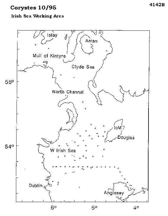
The work is directed at a better understanding of the dynamics of the North Channel which control the flushing characteristics of the Irish Sea. Net outflow from the Irish Sea is northward but there are apparently long periods of inflow on the western side of the channel. It is not known to what extent outflowing water recirculates and extends southward along the Irish coast or what importance inflows of Atlantic water have on flushing characteristics of the region. Variability in the flow regime and factors governing it are poorly understood. The main sampling aims of the cruise were:
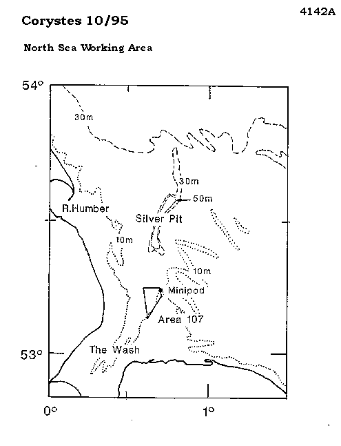
1. To deploy and recover mooring arrays in the North Channel and western Irish Sea. 2. Deploy and retrieve free floating ARGOS buoys in the North Channel and western Irish Sea to determine the Lagrangian circulation. 3. Undertake associated physical and biological surveys of the region in support of 1) and 2). 4. Continue inter-comparisons of the Valeport BFM308 and Aanderaa RCM-7 current meters. 5. Undertake SCANFISH trials. 6. Measure near bed velocities in the vicinity of a munitions dumping site in the North Channel. 7. If possible, recover the Minipod at the sand extraction site Area 107 in the outer Wash. Failing this, service the guard buoy marking the position of the minipod. 8. Test for acoustic interference with the Tritech alimeter on the CTD rosette. |
| Ship | RV Corystes |
| Departure Port | Lowestoft, United Kingdom |
| Departure Date | 1995-09-25 |
| Arrival Port | Lowestoft, United Kingdom |
| Arrival Date | 1995-10-17 |
| Principal Scientist(s) | Juan Brown (Ministry of Agriculture, Fisheries and Food Lowestoft Fisheries Laboratory) |
| Responsible Organisation | Ministry of Agriculture, Fisheries and Food Lowestoft Fisheries Laboratory |
| Associated Project(s) | |
| IHB Sea Areas Visited | North Sea, Irish Sea and St. George's Channel |
| Marsden Squares Visited | 181;1/181;2/181;3/181;4/216;1 |
| Work Area Description | Irish Sea, North Channel, Malin Shelf and North Sea |
| Unable to lookup cruise bounds at this time | |
| Work Area Bounding Polygon | |
| Southern Limit | unknown |
| Northern Limit | unknown |
| Western Limit | unknown |
| Eastern Limit | unknown |
Cruise Inventory Datasets
| Physical oceanography | |
|---|---|
| CTD stations |
Quantity:
number of stations =
5
Description: also 260 miles undulating CTD |
| Current meters |
Quantity:
number of stations =
3
Description: 5 current meters recovered |
| Current profiler (eg ADCP) |
Quantity:
activity duration in days =
20
Description: continuous ADCP |
| Surface drifters/drifting buoys |
Quantity:
number of deployments =
9
Description: satellite tracked drifting buoys |
| Surface measurements underway (T,S) |
Quantity:
activity duration in days =
20
Description: continuous T & S |
| Chemical oceanography | |
| Ammonia |
Quantity:
number of samples =
97
Description: |
| Nitrate |
Quantity:
number of samples =
97
Description: |
| Nitrite |
Quantity:
number of samples =
97
Description: |
| Phosphate |
Quantity:
number of samples =
97
Description: |
| Silicate |
Quantity:
number of samples =
97
Description: |
| Contamination | |
| Suspended matter |
Quantity:
number of stations =
5
Description: |
| Biology and fisheries | |
| Phytoplankton pigs (eg chlorophyll, fluorescence) |
Quantity:
number of samples =
97
Description: |
Cruise Inventory Mooring/Buoy Operations
| Latitude | Longitude | Data type | Description |
|---|---|---|---|
| 53° 30' N | 5° 19' W | Current meters | 2 moored c/m recovered (102days) |
| 54° 18' N | 5° 6' W | Current meters | 3 moored c/m recovered (42days) |
| 54° 51' N | 5° 22' W | Current meters |
Summary of BODC Data Holdings for the Cruise
National Oceanographic Database
Summary
| # Series | Instrument Description | Parameters |
|---|---|---|
| 5 | CTD/STD cast |
Concentration of suspended particulate material in the water column Salinity of the water column Temperature of the water column Transmittance and attenuance of the water column Vertical spatial coordinates |
Note: Parameter terms are taken from the BODC Parameter Discovery Vocabulary XML (SKOS)
Full List
| BODC Reference | Instrument Description | Date/Time | Location | |
|---|---|---|---|---|
| 601280 | CTD/STD cast | 1995-10-12 17:02Z | 53° 40' N, 5° 15' W | Click for more |
| 601292 | CTD/STD cast | 1995-10-12 18:30Z | 53° 40' N, 5° 30' W | Click for more |
| 601311 | CTD/STD cast | 1995-10-12 20:05Z | 53° 40' N, 5° 45' W | Click for more |
| 601323 | CTD/STD cast | 1995-10-12 21:58Z | 53° 33' N, 5° 30' W | Click for more |
| 601335 | CTD/STD cast | 1995-10-12 23:30Z | 53° 47' N, 5° 25' W | Click for more |
Project Database
No data currently held for this cruise in the BODC Project Database
