BODC Cruise Metadata Report for FRV Clupea (74CU) cruise 1097C
Introduction
This report collates information from the BODC cruise inventory and oceanographic databases. It presents
- Cruise Inventory Information
- A summary of BODC data holdings for the cruise from the
- References - including cruise tracks and cruise reports
Cruise Inventory Information
| Long name | FRV Clupea (74CU) cruise 1097C |
|---|---|
| Short name | 1097C |
| Objectives and Narrative |
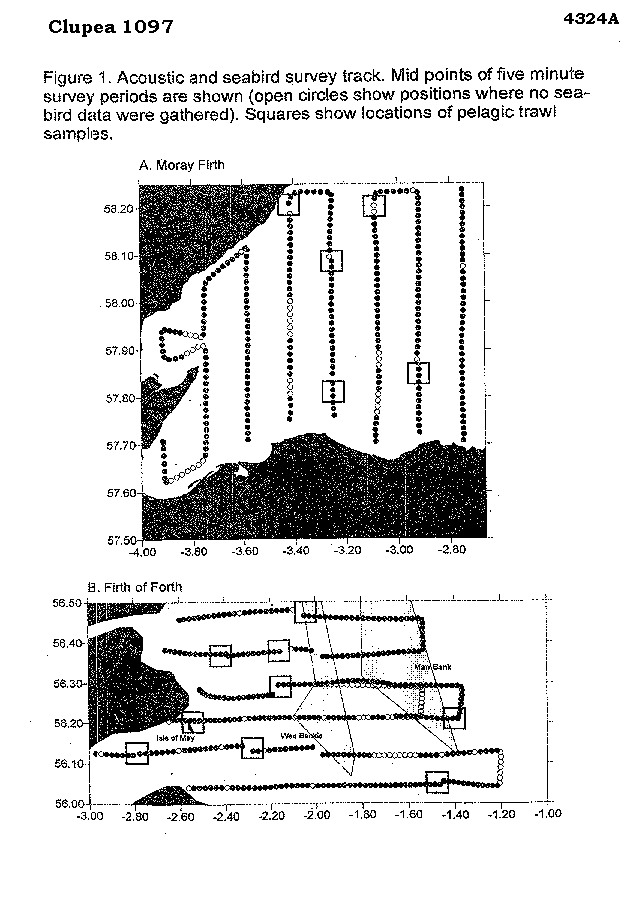
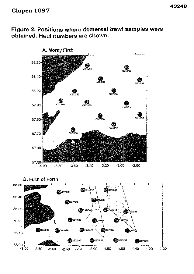
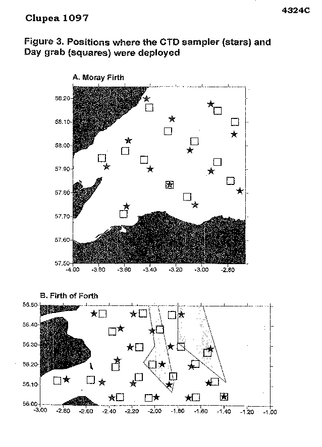
1. To carry out an acoustic survey, backed up by pelagic trawling, to determine the biomass and distribution of pelagic fish in the inner Moray Firth and in an area off the Firth of Forth which included the Wee Bankie and Marr Bank.
2. To assess the abundance and distribution of seabirds in both study areas using standard transect census techniques. 3. To locate, in the Firth of Forth study area, the feeding sites of radio tagged kittiwakes, guillemots and shags breeding on the Isle of May. 4. To record the location of all marine mammals observed at sea. 5. To map seabed sediment type using the acoustic system, RoxAnn, and to collect sediment samples to "groundtruth" the RoxAnn data. 6. To determine spatial variation in the water temperature and salinity profile within each study area. 7. To carry out a bottom trawl survey to determine the abundance, distribution and length composition of piscivorous demersal fish species in each study area. 8. To collect stomach samples from piscivorous fish to determine spatial variation in their diet. 9. To determine weight-lenth relationships for each fish predator species, and examine spatial variation in fish condition. |
| Ship | FRV Clupea |
| Departure Port | Fraserburgh, United Kingdom |
| Departure Date | 1997-06-17 |
| Arrival Port | Fraserburgh, United Kingdom |
| Arrival Date | 1997-07-07 |
| Principal Scientist(s) | Simon Greenstreet (Fisheries Research Services Aberdeen Marine Laboratory) |
| Responsible Organisation | Fisheries Research Services Aberdeen Marine Laboratory |
| Associated Project(s) | |
| IHB Sea Areas Visited | North Sea |
| Marsden Squares Visited | 181;3 |
| Work Area Description | Inner Moray Forth and off the Firth of Forth |
| Unable to lookup cruise bounds at this time | |
| Work Area Bounding Polygon | |
| Southern Limit | unknown |
| Northern Limit | unknown |
| Western Limit | unknown |
| Eastern Limit | unknown |
Cruise Inventory Datasets
| Physical oceanography | |
|---|---|
| CTD stations |
Quantity:
number of profiles =
33
Description: SBE CTD |
| Biology and fisheries | |
| Birds |
Quantity:
track kilometres =
1018
Description: Birds obs |
| Demersal fish |
Quantity:
number of hauls =
34
Description: Trawl Hauls |
| Other biological/fisheries measurement | Description: Radio tracking birds |
| Pelagic fish |
Quantity:
number of hauls =
14
Description: Trawl hauls PT 154 |
| Geology and geophysics | |
| Grab |
Quantity:
number of samples =
33
Description: Day Grabs |
| Other geological/geophysical measurements |
Quantity:
track kilometres =
1018
Description: RoxAnn |
Cruise Inventory Mooring/Buoy Operations
No information on datasets is currently available
Summary of BODC Data Holdings for the Cruise
National Oceanographic Database
Summary
| # Series | Instrument Description | Parameters |
|---|---|---|
| 32 | CTD/STD cast |
Electrical conductivity of the water column Reference numbers Salinity of the water column Temperature of the water column Vertical spatial coordinates |
Note: Parameter terms are taken from the BODC Parameter Discovery Vocabulary XML (SKOS)
Full List
| BODC Reference | Instrument Description | Date/Time | Location | |
|---|---|---|---|---|
| 479634 | CTD/STD cast | 1997-06-27 11:50Z | 56° 7' N, 2° 46' W | Click for more |
| 479646 | CTD/STD cast | 1997-06-29 09:04Z | 56° 7' N, 2° 29' W | Click for more |
| 479658 | CTD/STD cast | 1997-06-29 10:07Z | 56° 2' N, 2° 22' W | Click for more |
| 479671 | CTD/STD cast | 1997-06-29 13:45Z | 56° 2' N, 1° 59' W | Click for more |
| 479683 | CTD/STD cast | 1997-06-29 15:10Z | 56° 2' N, 1° 42' W | Click for more |
| 479695 | CTD/STD cast | 1997-06-30 05:35Z | 56° 3' N, 1° 24' W | Click for more |
| 479702 | CTD/STD cast | 1997-06-30 06:28Z | 56° 6' N, 1° 31' W | Click for more |
| 479714 | CTD/STD cast | 1997-06-30 09:46Z | 56° 16' N, 1° 31' W | Click for more |
| 479726 | CTD/STD cast | 1997-06-30 11:00Z | 56° 12' N, 1° 40' W | Click for more |
| 479738 | CTD/STD cast | 1997-06-30 14:44Z | 56° 6' N, 1° 52' W | Click for more |
| 479751 | CTD/STD cast | 1997-07-01 14:05Z | 56° 13' N, 2° 19' W | Click for more |
| 479763 | CTD/STD cast | 1997-07-01 16:08Z | 56° 6' N, 2° 11' W | Click for more |
| 479775 | CTD/STD cast | 1997-07-02 07:00Z | 56° 17' N, 2° 13' W | Click for more |
| 479787 | CTD/STD cast | 1997-07-02 08:20Z | 56° 12' N, 1° 56' W | Click for more |
| 479799 | CTD/STD cast | 1997-07-02 11:35Z | 56° 18' N, 1° 51' W | Click for more |
| 479806 | CTD/STD cast | 1997-07-02 14:30Z | 56° 22' N, 2° 1' W | Click for more |
| 479818 | CTD/STD cast | 1997-07-02 18:00Z | 56° 23' N, 2° 18' W | Click for more |
| 479831 | CTD/STD cast | 1997-07-03 06:15Z | 56° 27' N, 2° 31' W | Click for more |
| 479843 | CTD/STD cast | 1997-07-03 09:35Z | 56° 27' N, 2° 11' W | Click for more |
| 479855 | CTD/STD cast | 1997-07-03 11:09Z | 56° 27' N, 1° 46' W | Click for more |
| 479867 | CTD/STD cast | 1997-07-04 10:47Z | 58° 3' N, 2° 45' W | Click for more |
| 479879 | CTD/STD cast | 1997-07-04 12:05Z | 58° 10' N, 2° 55' W | Click for more |
| 479880 | CTD/STD cast | 1997-07-04 15:50Z | 58° 6' N, 3° 13' W | Click for more |
| 479892 | CTD/STD cast | 1997-07-05 04:25Z | 58° 12' N, 3° 25' W | Click for more |
| 479911 | CTD/STD cast | 1997-07-05 07:48Z | 58° 1' N, 3° 34' W | Click for more |
| 479923 | CTD/STD cast | 1997-07-05 09:00Z | 57° 54' N, 3° 44' W | Click for more |
| 479935 | CTD/STD cast | 1997-07-05 12:10Z | 57° 54' N, 3° 24' W | Click for more |
| 479947 | CTD/STD cast | 1997-07-06 05:46Z | 57° 45' N, 3° 3' W | Click for more |
| 479959 | CTD/STD cast | 1997-07-06 07:20Z | 57° 50' N, 3° 15' W | Click for more |
| 479960 | CTD/STD cast | 1997-07-06 10:29Z | 57° 58' N, 3° 5' W | Click for more |
| 479972 | CTD/STD cast | 1997-07-06 12:10Z | 57° 53' N, 2° 55' W | Click for more |
| 479984 | CTD/STD cast | 1997-07-06 14:44Z | 57° 48' N, 2° 42' W | Click for more |
Project Database
No data currently held for this cruise in the BODC Project Database
