BODC Cruise Metadata Report for FRV Clupea (74CU) cruise 1597C
Introduction
This report collates information from the BODC cruise inventory and oceanographic databases. It presents
- Cruise Inventory Information
- A summary of BODC data holdings for the cruise from the
- References - including cruise tracks and cruise reports
Cruise Inventory Information
| Long name | FRV Clupea (74CU) cruise 1597C |
|---|---|
| Short name | 1597C |
| Objectives and Narrative |
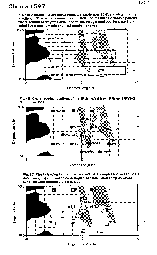
1. To carry out an echo-integrator survey to determine the biomass and distribution of pelagic fish in an area off the Firth of Forth encompassing the Wee Bankie and Marr Bank sandeel grounds.
2. To sample areas with high densities of pelagic fish using a pelagic trawl in order to determine fish species, size and age composition and weight-length relationships. 3. To map seabed sediments using RoxAnn, an acoustic survey technique, with associated sediment sampling by Day grab to "groundtruth" the acoustic data. 4. To determine spatial variation in water temperature and salinity depth profiles using a Seabird CTD instrument. 5. To determine the numbers and distribution of avian and mammalian predators in the study area using transect census methods. 6.To determine the abundance and distribution of piscivorous demersal fish species by bottom trawl survey. 7. To assess the length and age composition of these piscivorous fish predators, together with their age-length and length-weight relationships, and to collect stomach samples for diet and food consumption analysis. Also, to examine the livers and gonads (where possible) of these demersal fish for assessment of body condition. |
| Ship | FRV Clupea |
| Departure Port | Fraserburgh, United Kingdom |
| Departure Date | 1997-09-10 |
| Arrival Port | Fraserburgh, United Kingdom |
| Arrival Date | 1997-09-19 |
| Principal Scientist(s) | Simon Greenstreet (Fisheries Research Services Aberdeen Marine Laboratory) |
| Responsible Organisation | Fisheries Research Services Aberdeen Marine Laboratory |
| Associated Project(s) | |
| IHB Sea Areas Visited | North Sea |
| Marsden Squares Visited | 181;3 |
| Work Area Description | Firth of Forth; Wee Bankie; Marr Bank |
| Unable to lookup cruise bounds at this time | |
| Work Area Bounding Polygon | |
| Southern Limit | unknown |
| Northern Limit | unknown |
| Western Limit | unknown |
| Eastern Limit | unknown |
Cruise Inventory Datasets
| Physical oceanography | |
|---|---|
| CTD stations |
Quantity:
number of profiles =
15
Description: SBE CTD dips |
| Biology and fisheries | |
| Birds |
Quantity:
track kilometres =
500
Description: Bird observations. |
| Demersal fish |
Quantity:
number of hauls =
15
Description: Demersal trawl hauls |
| Mammals and reptiles |
Quantity:
track kilometres =
500
Description: all casual sightings of seals and cetaceans were noted. |
| Pelagic fish |
Quantity:
number of hauls =
2
Description: International Young Gadoid Pelagic Trawl. |
| Geology and geophysics | |
| Grab |
Quantity:
number of samples =
15
Description: Day Grabs |
| Other geological/geophysical measurements |
Quantity:
track kilometres =
500
Description: RoxAnn |
Cruise Inventory Mooring/Buoy Operations
No information on datasets is currently available
Summary of BODC Data Holdings for the Cruise
National Oceanographic Database
Summary
| # Series | Instrument Description | Parameters |
|---|---|---|
| 15 | CTD/STD cast |
Electrical conductivity of the water column Reference numbers Salinity of the water column Temperature of the water column Vertical spatial coordinates |
Note: Parameter terms are taken from the BODC Parameter Discovery Vocabulary XML (SKOS)
Full List
| BODC Reference | Instrument Description | Date/Time | Location | |
|---|---|---|---|---|
| 480383 | CTD/STD cast | 1997-09-14 14:08Z | 56° 27' N, 2° 28' W | Click for more |
| 480395 | CTD/STD cast | 1997-09-14 15:38Z | 56° 17' N, 2° 13' W | Click for more |
| 480402 | CTD/STD cast | 1997-09-15 14:25Z | 56° 1' N, 2° 0' W | Click for more |
| 480414 | CTD/STD cast | 1997-09-16 06:10Z | 56° 7' N, 2° 33' W | Click for more |
| 480426 | CTD/STD cast | 1997-09-16 08:57Z | 56° 14' N, 2° 20' W | Click for more |
| 480438 | CTD/STD cast | 1997-09-16 11:18Z | 56° 12' N, 1° 58' W | Click for more |
| 480451 | CTD/STD cast | 1997-09-16 12:15Z | 56° 9' N, 1° 50' W | Click for more |
| 480463 | CTD/STD cast | 1997-09-16 17:02Z | 56° 6' N, 2° 10' W | Click for more |
| 480475 | CTD/STD cast | 1997-09-17 07:08Z | 56° 2' N, 1° 43' W | Click for more |
| 480487 | CTD/STD cast | 1997-09-17 09:48Z | 56° 7' N, 1° 29' W | Click for more |
| 480499 | CTD/STD cast | 1997-09-17 12:26Z | 56° 15' N, 1° 33' W | Click for more |
| 480506 | CTD/STD cast | 1997-09-17 15:23Z | 56° 17' N, 1° 50' W | Click for more |
| 480518 | CTD/STD cast | 1997-09-17 17:45Z | 56° 27' N, 1° 49' W | Click for more |
| 480531 | CTD/STD cast | 1997-09-18 07:23Z | 56° 22' N, 2° 0' W | Click for more |
| 480543 | CTD/STD cast | 1997-09-18 08:10Z | 56° 28' N, 2° 6' W | Click for more |
Project Database
No data currently held for this cruise in the BODC Project Database
