BODC Cruise Metadata Report for FRV Clupea (74CU) cruise 1098C
Introduction
This report collates information from the BODC cruise inventory and oceanographic databases. It presents
- Cruise Inventory Information
- A summary of BODC data holdings for the cruise from the
- References - including cruise tracks and cruise reports
Cruise Inventory Information
| Long name | FRV Clupea (74CU) cruise 1098C |
|---|---|
| Short name | 1098C |
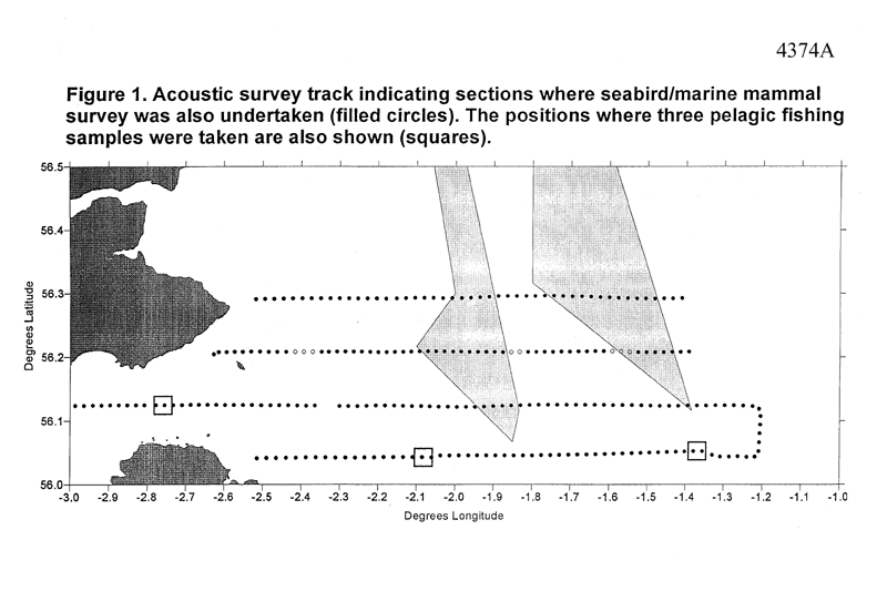
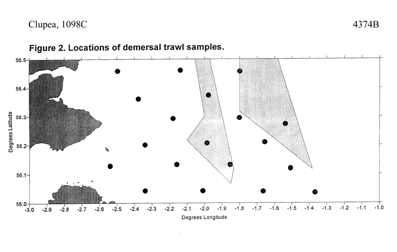
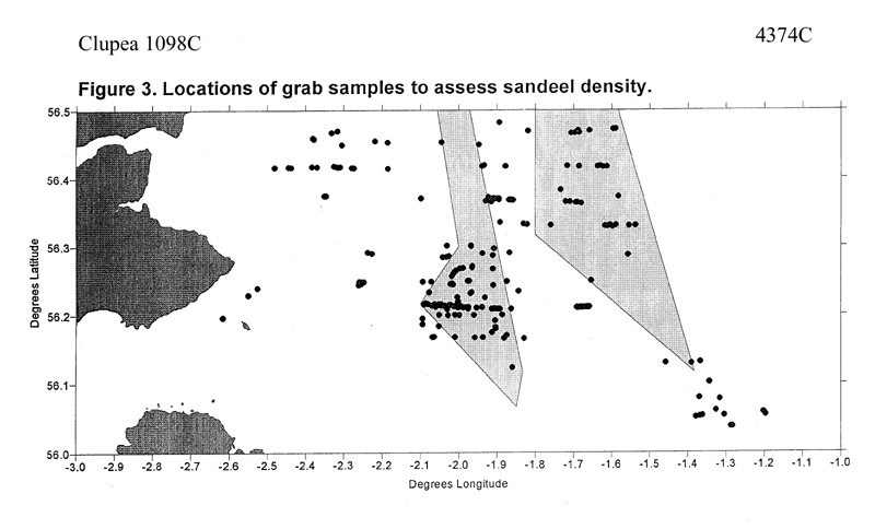
| Objectives and Narrative | To carry out an acoustic survey, backed up by pelagic trawling, to determine the biomass and distribution of pelagic fish in an area off the Firth of Froth which included the Wee Bankie and Marr Bank. To assess the abundance and distribution of seabirds in the area using standard transect census techniques and to locate the feeding sites of dye-marked kittiwakes breeding on the Isle of May. To record the location of all marine mammals observed at sea. To map seabed sediment type using the acoustic system RoxAnn and to collect sediment samples to "groundtruth" the RoxAnn data. To determine spatial variation in the water temperature and salinity profile within the study area. To carry out a bottom trawl survey to determine the abundance, distribution and length composition of piscivorous demersal fish species and to collect stomach samples from these fish to determine spatial variation in their diet. To determine weight-length relationships for each fish predator species, and examine spatial variation in fish condition. To carry out a night-time grab survey, over sediments previously determined as suitable sandeel habitat, to assess sandeel abundance and distribution. The sediment samples collected during this survey will also be used to assess the RoxAnn derived sandeel habitat map. |
| Ship | FRV Clupea |
| Departure Port | Fraserburgh, United Kingdom |
| Departure Date | 1998-06-12 |
| Arrival Port | Fraserburgh, United Kingdom |
| Arrival Date | 1998-06-29 |
| Principal Scientist(s) | Simon Greenstreet (Fisheries Research Services Aberdeen Marine Laboratory) |
| Responsible Organisation | Fisheries Research Services Aberdeen Marine Laboratory |
| Associated Project(s) | |
| IHB Sea Areas Visited | North Sea |
| Marsden Squares Visited | 181;3 |
| Work Area Description | Firth of Forth |
| Unable to lookup cruise bounds at this time | |
| Work Area Bounding Polygon | |
| Southern Limit | unknown |
| Northern Limit | unknown |
| Western Limit | unknown |
| Eastern Limit | unknown |
Cruise Inventory Datasets
| Physical oceanography | |
|---|---|
| CTD stations |
Quantity:
number of profiles =
19
Description: |
| Biology and fisheries | |
| Acoustic reflection on marine organisms. |
Quantity:
number of track lines =
4
Description: Transects |
| Birds |
Quantity:
number of surveys =
3
Description: |
| Demersal fish |
Quantity:
number of hauls =
19
Description: Trawls, for catch weight, length/freq distribution whiting, haddock, cod, herring, sprats and sandeels |
| Mammals and reptiles |
Quantity:
number of surveys =
3
Description: |
| Pelagic fish |
Quantity:
number of track lines =
4
Description: Transects |
| Pelagic fish |
Quantity:
number of hauls =
3
Description: Trawls |
| Geology and geophysics | |
| Grab |
Quantity:
number of samples =
209
Description: Grabs, nighttime sampling, sediment particle size, sandeels |
| Grab |
Quantity:
number of samples =
19
Description: Grabs, sediment particle size |
Cruise Inventory Mooring/Buoy Operations
No information on datasets is currently available
Summary of BODC Data Holdings for the Cruise
National Oceanographic Database
Summary
| # Series | Instrument Description | Parameters |
|---|---|---|
| 19 | CTD/STD cast |
Electrical conductivity of the water column Reference numbers Salinity of the water column Temperature of the water column Vertical spatial coordinates |
Note: Parameter terms are taken from the BODC Parameter Discovery Vocabulary XML (SKOS)
Full List
| BODC Reference | Instrument Description | Date/Time | Location | |
|---|---|---|---|---|
| 511494 | CTD/STD cast | 1998-06-18 06:10Z | 56° 7' N, 2° 31' W | Click for more |
| 511501 | CTD/STD cast | 1998-06-18 07:40Z | 56° 10' N, 2° 21' W | Click for more |
| 511513 | CTD/STD cast | 1998-06-18 10:15Z | 56° 12' N, 1° 57' W | Click for more |
| 511525 | CTD/STD cast | 1998-06-18 11:55Z | 56° 12' N, 1° 40' W | Click for more |
| 511537 | CTD/STD cast | 1998-06-18 13:50Z | 56° 17' N, 1° 31' W | Click for more |
| 511549 | CTD/STD cast | 1998-06-18 15:35Z | 56° 7' N, 1° 28' W | Click for more |
| 511550 | CTD/STD cast | 1998-06-19 05:40Z | 56° 2' N, 1° 24' W | Click for more |
| 511562 | CTD/STD cast | 1998-06-19 07:10Z | 56° 2' N, 1° 37' W | Click for more |
| 511574 | CTD/STD cast | 1998-06-19 10:30Z | 56° 7' N, 1° 52' W | Click for more |
| 511586 | CTD/STD cast | 1998-06-19 12:40Z | 56° 3' N, 1° 58' W | Click for more |
| 511598 | CTD/STD cast | 1998-06-19 15:00Z | 56° 7' N, 2° 10' W | Click for more |
| 511605 | CTD/STD cast | 1998-06-20 06:00Z | 56° 2' N, 2° 18' W | Click for more |
| 511617 | CTD/STD cast | 1998-06-20 10:35Z | 56° 18' N, 2° 9' W | Click for more |
| 511629 | CTD/STD cast | 1998-06-20 12:50Z | 56° 17' N, 1° 50' W | Click for more |
| 511630 | CTD/STD cast | 1998-06-21 06:50Z | 56° 22' N, 2° 21' W | Click for more |
| 511642 | CTD/STD cast | 1998-06-21 08:50Z | 56° 22' N, 2° 1' W | Click for more |
| 511654 | CTD/STD cast | 1998-06-21 11:25Z | 56° 27' N, 1° 48' W | Click for more |
| 511666 | CTD/STD cast | 1998-06-21 13:30Z | 56° 28' N, 2° 6' W | Click for more |
| 511678 | CTD/STD cast | 1998-06-22 08:30Z | 56° 27' N, 2° 30' W | Click for more |
Project Database
No data currently held for this cruise in the BODC Project Database
