BODC Cruise Metadata Report for RRS James Clark Ross (74JC) cruise JR20050829 (JR127)
Introduction
This report collates information from the BODC cruise inventory and oceanographic databases. It presents
- Cruise Inventory Information
- A summary of BODC data holdings for the cruise from the
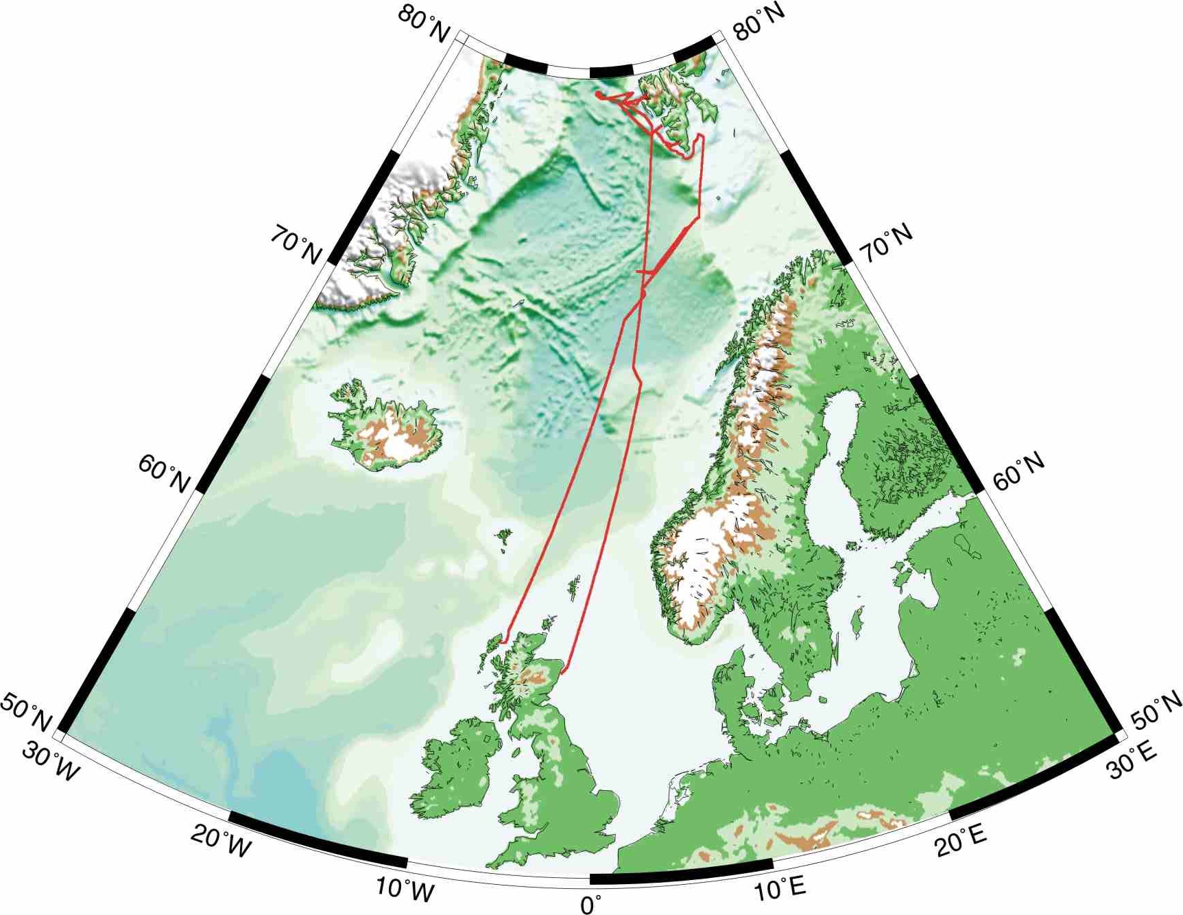
- References - including cruise tracks and cruise reports
Cruise Inventory Information
| Long name | RRS James Clark Ross (74JC) cruise JR20050829 (JR127) |
|---|---|
| Short name | JR20050829 (JR127) |
| Objectives and Narrative |
Purpose of cruise is to address the following scientific questions: Where and how is energy dissipated in fjords? How does bioturbation vary in response to environmental variables? Are deep-sea proxy-indicators of environmental and climatic change applicable to high resolution sedimentary records in fjordic environment? What are the roles of physical submarine features in driving carbon flow through the benthic biosphere at the northern European continental margin? To what extent do benthic faunal composition and size structure determine processes of carbon dynamics and biogeochemical provinces at the benthic boundary?
Objectives: 1) Physical/Biological/Geochemical transect along Bear Island Fan 2) Physical/Biological/Geochemical transect along axis of Kongsfjord 3) Physical/Biological/Geochemical transect on the Voring Plateau 4) Physical/Biological/Geochemical transect on the Yermak Plateau 5) To service a mooring in Kongsfjord 6) To obtain piston cores in the Molloy Deep and Kongsfjord/Krossfjord 7) Hygrographic sections along&across the West Spitsbergen Shelf Time was lost due to bad weather during the trip. In total around 85% of the work was completed. Only objective 5) was fully achieved, objective 4) was lost due to a mixture of bad weather and ice cover. All the other objectives were partly achieved. |
| Ship | RRS James Clark Ross |
| Departure Port | Stornoway, United Kingdom |
| Departure Date | 2005-08-29 |
| Arrival Port | Aberdeen, United Kingdom |
| Arrival Date | 2005-09-22 |
| Principal Scientist(s) | Graham B Shimmield (Scottish Association for Marine Science) |
| Responsible Organisation | Scottish Association for Marine Science |
| Associated Project(s) | Northern Seas Programme |
| IHB Sea Areas Visited | Norwegian Sea |
| Marsden Squares Visited | 252/288 |
| Work Area Description | Norwegian Sea, Fram Strait |
| Unable to lookup cruise bounds at this time | |
| Work Area Bounding Polygon | |
| Southern Limit | unknown |
| Northern Limit | unknown |
| Western Limit | unknown |
| Eastern Limit | unknown |
Cruise Inventory Datasets
| Physical oceanography | |
|---|---|
| CTD stations |
Quantity:
number of stations =
77
Description: SeaBird 9/11+ CTD |
| CTD stations |
Quantity:
number of stations =
16
Description: SBE19 CTD lowered from JCR Tender in Kongsfjord |
| Current profiler (eg ADCP) |
Quantity:
activity duration in days =
25
Description: RDI Ocean Surveyor 75KHz run for the duration of JR75 |
| Subsurface temperature and salinity measurements |
Quantity:
activity duration in days =
25
Description: Underway measurements made throughout the cruise for surface temperature, salinity & fluo |
| Water bottle stations |
Quantity:
number of stations =
16
Description: NIO water samples taken at same time as SBE19 for subsequent O18 isotope analysis |
| Water bottle stations |
Quantity:
number of stations =
77
Description: Water Samples taken from SBE CTD, O2, Chl, DOC, Ra, Pb, Po, SPMs & O18 |
| Meteorology | |
| Routine standard measurements |
Quantity:
activity duration in days =
25
Description: Routine standard meteoroogical measurements made throughout the cruise |
| Geology and geophysics | |
| Core - soft bottom |
Quantity:
number of stations =
6
Description: Ukors Piston Corer, cores returned to lab for geological examination |
| Core - soft bottom |
Quantity:
number of stations =
38
Description: SAMS Mega Corer - cores taken for bilogical analysis, chemical & geochemical analysis |
| Core - soft bottom |
Quantity:
number of stations =
2
Description: NIOZ Box corer - sub sampled for benthic biological analysis |
| Multi-beam echosounding |
Quantity:
activity duration in days =
25
Description: Swath & Topas onboard systems run for the duration of the cruise |
Cruise Inventory Mooring/Buoy Operations
| Latitude | Longitude | Data type | Description |
|---|---|---|---|
| 79° 1' N | 11° 46' E | Current meters | Deployment of mooring. 2 S4's, 2 sed traps, 3 T/P/S loggers, 2 fluorometers, 12 Minilogger |
| 78° 57' N | 11° 49' E | Current profiler (eg ADCP) | Recovery of Mooring, ADCP + 3 miniloggers, deployed Sept 2004 |
| 73° 40' N | 13° 47' E | Oxygen | Elinor Chamber Lander |
| 78° 58' N | 6° 42' E | Oxygen | Elinor Chamber Lander |
| 78° 58' N | 6° 42' E | Oxygen | Profiling Lander |
| 70° 30' N | 4° 47' E | Oxygen | Profiling Lander |
Summary of BODC Data Holdings for the Cruise
National Oceanographic Database
Summary
| # Series | Instrument Description | Parameters |
|---|---|---|
| 75 | CTD/STD cast |
Chlorophyll pigment concentrations in water bodies Dissolved oxygen parameters in the water column Reference numbers Salinity of the water column Temperature of the water column Transmittance and attenuance of the water column Vertical spatial coordinates |
Note: Parameter terms are taken from the BODC Parameter Discovery Vocabulary XML (SKOS)
Full List
| BODC Reference | Instrument Description | Date/Time | Location | |
|---|---|---|---|---|
| 897240 | CTD/STD cast | 2005-09-02 11:36Z | 70° 30' N, 3° 57' E | Click for more |
| 897252 | CTD/STD cast | 2005-09-02 15:07Z | 70° 30' N, 3° 57' E | Click for more |
| 897264 | CTD/STD cast | 2005-09-02 16:09Z | 70° 30' N, 3° 57' E | Click for more |
| 897276 | CTD/STD cast | 2005-09-02 18:20Z | 70° 30' N, 4° 0' E | Click for more |
| 897288 | CTD/STD cast | 2005-09-02 20:47Z | 70° 30' N, 4° 0' E | Click for more |
| 897307 | CTD/STD cast | 2005-09-02 23:13Z | 70° 30' N, 4° 0' E | Click for more |
| 897319 | CTD/STD cast | 2005-09-03 10:52Z | 71° 37' N, 6° 23' E | Click for more |
| 897320 | CTD/STD cast | 2005-09-05 22:05Z | 72° 9' N, 8° 0' E | Click for more |
| 897332 | CTD/STD cast | 2005-09-06 13:17Z | 73° 40' N, 13° 47' E | Click for more |
| 897344 | CTD/STD cast | 2005-09-06 15:11Z | 73° 40' N, 13° 47' E | Click for more |
| 897356 | CTD/STD cast | 2005-09-07 05:24Z | 73° 57' N, 15° 34' E | Click for more |
| 897368 | CTD/STD cast | 2005-09-07 06:46Z | 73° 57' N, 15° 34' E | Click for more |
| 897381 | CTD/STD cast | 2005-09-07 07:32Z | 73° 57' N, 15° 34' E | Click for more |
| 897393 | CTD/STD cast | 2005-09-07 08:41Z | 73° 57' N, 15° 34' E | Click for more |
| 897400 | CTD/STD cast | 2005-09-07 09:34Z | 73° 57' N, 15° 34' E | Click for more |
| 897412 | CTD/STD cast | 2005-09-07 10:35Z | 73° 57' N, 15° 34' E | Click for more |
| 897424 | CTD/STD cast | 2005-09-08 09:54Z | 76° 48' N, 18° 8' E | Click for more |
| 897436 | CTD/STD cast | 2005-09-08 16:05Z | 76° 28' N, 15° 45' E | Click for more |
| 897448 | CTD/STD cast | 2005-09-08 16:49Z | 76° 28' N, 15° 44' E | Click for more |
| 897461 | CTD/STD cast | 2005-09-08 18:52Z | 76° 40' N, 14° 55' E | Click for more |
| 897473 | CTD/STD cast | 2005-09-08 21:32Z | 76° 54' N, 13° 49' E | Click for more |
| 897485 | CTD/STD cast | 2005-09-08 23:01Z | 77° 3' N, 13° 23' E | Click for more |
| 897497 | CTD/STD cast | 2005-09-09 00:10Z | 77° 3' N, 13° 22' E | Click for more |
| 897504 | CTD/STD cast | 2005-09-09 00:44Z | 77° 3' N, 13° 22' E | Click for more |
| 897516 | CTD/STD cast | 2005-09-09 01:24Z | 77° 3' N, 13° 22' E | Click for more |
| 897528 | CTD/STD cast | 2005-09-09 02:11Z | 77° 3' N, 13° 22' E | Click for more |
| 897541 | CTD/STD cast | 2005-09-09 03:11Z | 77° 3' N, 13° 22' E | Click for more |
| 897553 | CTD/STD cast | 2005-09-09 15:05Z | 77° 10' N, 13° 9' E | Click for more |
| 897565 | CTD/STD cast | 2005-09-09 16:31Z | 77° 21' N, 12° 52' E | Click for more |
| 897577 | CTD/STD cast | 2005-09-09 17:56Z | 77° 30' N, 12° 30' E | Click for more |
| 897589 | CTD/STD cast | 2005-09-09 19:16Z | 77° 39' N, 12° 7' E | Click for more |
| 897590 | CTD/STD cast | 2005-09-09 20:06Z | 77° 39' N, 12° 7' E | Click for more |
| 897608 | CTD/STD cast | 2005-09-09 20:57Z | 77° 39' N, 12° 7' E | Click for more |
| 897621 | CTD/STD cast | 2005-09-09 21:46Z | 77° 39' N, 12° 7' E | Click for more |
| 897633 | CTD/STD cast | 2005-09-09 22:35Z | 77° 39' N, 12° 7' E | Click for more |
| 897645 | CTD/STD cast | 2005-09-10 01:33Z | 77° 48' N, 12° 25' E | Click for more |
| 897657 | CTD/STD cast | 2005-09-10 02:24Z | 77° 46' N, 12° 9' E | Click for more |
| 897669 | CTD/STD cast | 2005-09-10 03:19Z | 77° 43' N, 12° 47' E | Click for more |
| 897670 | CTD/STD cast | 2005-09-10 04:06Z | 77° 41' N, 12° 30' E | Click for more |
| 897682 | CTD/STD cast | 2005-09-10 05:19Z | 77° 37' N, 11° 52' E | Click for more |
| 897694 | CTD/STD cast | 2005-09-10 06:00Z | 77° 36' N, 11° 38' E | Click for more |
| 897701 | CTD/STD cast | 2005-09-10 06:49Z | 77° 34' N, 11° 19' E | Click for more |
| 897713 | CTD/STD cast | 2005-09-10 07:27Z | 77° 34' N, 11° 15' E | Click for more |
| 897725 | CTD/STD cast | 2005-09-10 08:27Z | 77° 33' N, 11° 0' E | Click for more |
| 897737 | CTD/STD cast | 2005-09-10 09:20Z | 77° 33' N, 11° 0' E | Click for more |
| 897749 | CTD/STD cast | 2005-09-10 10:10Z | 77° 33' N, 11° 0' E | Click for more |
| 897750 | CTD/STD cast | 2005-09-13 04:51Z | 79° 18' N, 9° 12' E | Click for more |
| 897762 | CTD/STD cast | 2005-09-13 13:58Z | 78° 58' N, 6° 42' E | Click for more |
| 897774 | CTD/STD cast | 2005-09-13 14:41Z | 78° 58' N, 6° 42' E | Click for more |
| 897786 | CTD/STD cast | 2005-09-13 16:11Z | 78° 58' N, 6° 42' E | Click for more |
| 897798 | CTD/STD cast | 2005-09-13 17:00Z | 78° 58' N, 6° 42' E | Click for more |
| 897805 | CTD/STD cast | 2005-09-13 18:13Z | 78° 58' N, 6° 42' E | Click for more |
| 897817 | CTD/STD cast | 2005-09-13 19:40Z | 78° 58' N, 6° 42' E | Click for more |
| 897829 | CTD/STD cast | 2005-09-14 00:02Z | 78° 58' N, 9° 24' E | Click for more |
| 897830 | CTD/STD cast | 2005-09-14 15:14Z | 78° 58' N, 11° 32' E | Click for more |
| 897842 | CTD/STD cast | 2005-09-14 15:53Z | 78° 58' N, 11° 32' E | Click for more |
| 897854 | CTD/STD cast | 2005-09-14 17:11Z | 79° 1' N, 11° 48' E | Click for more |
| 897866 | CTD/STD cast | 2005-09-14 17:47Z | 79° 1' N, 11° 45' E | Click for more |
| 897878 | CTD/STD cast | 2005-09-14 19:40Z | 79° 0' N, 11° 42' E | Click for more |
| 897891 | CTD/STD cast | 2005-09-14 20:30Z | 79° 0' N, 11° 39' E | Click for more |
| 897909 | CTD/STD cast | 2005-09-14 21:14Z | 78° 59' N, 11° 35' E | Click for more |
| 897910 | CTD/STD cast | 2005-09-14 22:01Z | 78° 58' N, 11° 33' E | Click for more |
| 897922 | CTD/STD cast | 2005-09-14 22:59Z | 78° 58' N, 11° 33' E | Click for more |
| 897934 | CTD/STD cast | 2005-09-14 23:53Z | 78° 58' N, 11° 33' E | Click for more |
| 897946 | CTD/STD cast | 2005-09-15 00:30Z | 78° 58' N, 11° 33' E | Click for more |
| 897958 | CTD/STD cast | 2005-09-15 01:16Z | 78° 58' N, 11° 33' E | Click for more |
| 897971 | CTD/STD cast | 2005-09-15 02:00Z | 78° 58' N, 11° 33' E | Click for more |
| 897983 | CTD/STD cast | 2005-09-16 00:46Z | 79° 1' N, 11° 46' E | Click for more |
| 897995 | CTD/STD cast | 2005-09-16 04:12Z | 78° 48' N, 9° 38' E | Click for more |
| 898009 | CTD/STD cast | 2005-09-16 15:16Z | 78° 19' N, 10° 37' E | Click for more |
| 898010 | CTD/STD cast | 2005-09-16 16:58Z | 78° 7' N, 11° 6' E | Click for more |
| 898022 | CTD/STD cast | 2005-09-16 17:31Z | 78° 7' N, 11° 6' E | Click for more |
| 898034 | CTD/STD cast | 2005-09-18 20:47Z | 68° 37' N, 7° 33' E | Click for more |
| 898046 | CTD/STD cast | 2005-09-19 15:17Z | 68° 1' N, 5° 13' E | Click for more |
| 898058 | CTD/STD cast | 2005-09-19 17:04Z | 68° 1' N, 5° 13' E | Click for more |
Project Database
No data currently held for this cruise in the BODC Project Database
