Metadata Report for BODC Series Reference Number 1781399
Metadata Summary
Problem Reports
Data Access Policy
Data Policy
Narrative Documents
Project Information
Data Activity or Cruise Information
Fixed Station Information
BODC Quality Flags
SeaDataNet Quality Flags
Metadata Summary
Data Description |
|||||||||||||||||||||||||
|
|||||||||||||||||||||||||
Data Identifiers |
|||||||||||||||||||||||||
|
|||||||||||||||||||||||||
Time Co-ordinates(UT) |
|||||||||||||||||||||||||
|
|||||||||||||||||||||||||
Spatial Co-ordinates | |||||||||||||||||||||||||
|
|||||||||||||||||||||||||
Parameters |
|||||||||||||||||||||||||
|
|||||||||||||||||||||||||
|
|||||||||||||||||||||||||
Problem Reports
No Problem Report Found in the Database
Data Access Policy
Western Boundary Time Series (WBTS) data access
The data from the Western Boundary Time Series (WBTS) project are freely available to all. The project scientists would appreciate it if the following acknowledgment was included in any publications that use this data;
"The Western Boundary Time Series data are made freely available by NOAA's Western Boundary Time Series project at https://www.aoml.noaa.gov/western-boundary-time-series/ and are funded by NOAA's Global Ocean Monitoring and Observing (GOMO) program."
Data Policy
Western Boundary Time Series (WBTS) data access
The data from the Western Boundary Time Series (WBTS) project are freely available to all. The project scientists would appreciate it if the following acknowledgment was included in any publications that use this data;
"The Western Boundary Time Series data are made freely available by NOAA's Western Boundary Time Series project at https://www.aoml.noaa.gov/western-boundary-time-series/ and are funded by NOAA's Global Ocean Monitoring and Observing (GOMO) program."
Narrative Documents
Sea Data Inverted Echo Sounder (IES)
The Sea Data Inverted Echo Sounder (IES) is an ocean bottom-moored instrument that measures the time it takes for an acoustic pulse to travel to the sea surface and back again. The IES can be equipped with an optional bottom pressure sensor.
The University of Rhode Island-Graduate School of Oceanography (URI-GSO) sold the designs of its Inverted Echo Sounder to Sea Data, who manufactured IESs for a few years in the 1980s. No information is available for the Sea Data IESs but users can refer to the URI-GSO website for information about how an IES works.
WBTS PIES data processing document
This document outlines the procedures undertaken to process and quality assure the pressure equipped inverted echo sounder (PIES) data collected under the Western Boundary Time Series (WBTS) project.
Originator's processing
The raw data are downloaded from the instrument and converted to ASCII format.
The following procedures are then performed:
-
The record length time mean is removed from the pressure series
-
Tides are removed from the pressure using a Response Analysis technique (Munk and Cartwright, 1966). An important note: The fortnightly tide signal is not removed as part of processing.
-
All channels are low pass filtered using a 2nd order Butterworth filter with a 72-hour cut-off (filtering done both forward and backward to avoid phase shifting). This effectively removes the tides from the travel time data as the signal is small.
-
Travel time is calibrated using concurrent CTD profiles into the equivalent travel time that would be measured at the constant common pressure surface of 1000 db. See Meinen and Watts (2000) and references therein for scientific argument and methodology.
-
The data are subsampled to one value per day at noon GMT.
References
Meinen C.S and Watts D.R., 2000. Vertical structure and transport on a transect across the North Atlantic Current near 42°N: Time series and mean. Journal of Geophysical Research, Vol 1-5, No C9, Pages 21,869-21,891, September 15.
Meinen C.S., Johns W.E., Garzoli S.L., Van Sebille E., Rayner D., Kanzow T. and Baringer M.O., 2012. Variability of the Deep Western Boundary Current at 26.57°N during 2004-2009, Deep-Sea Research Part II, 85:154-168, doi:10.1016/j.dsr2.2012.07.036.
Meinen C.S and Garlozi S.L., 2014. Attribution of Deep Western Boundary Current variability at 26.5°N. Deep Sea Research I, 90, 81-90, doi:10.1016/j.dsr.2014.04.016.
Munk W and Cartwright D.E., 1966. Tidal Spectroscopy and Prediction. Philosophical Transactions of the Royal Society of London, A 259, doi:10.1098/rsta.1966.0024.
BODC processing
Data are received after quality checks have been made and calibrations have been applied. The data files are submitted in ASCII format as one file per instrument.
Once the submitted data files are safely archived, the data undergo reformatting and banking procedures:
-
The processed data files are transferred into a common format, a NetCDF subset.
-
A timestamp of 12:00:00 is given to all measurements.
-
Standard parameter codes are assigned that accurately describe the data (see Parameter mapping section below).
-
Unit conversions are applied, if necessary, so that units are standardised (see Parameter mapping section below).
-
The data are screened visually and any spikes or instrument malfunctions can be clearly labelled with quality control flags.
-
Comprehensive documentation is prepared describing the collection, processing and quality of each data series.
-
Detailed metadata and documents are loaded to the database and linked to each series so that the information is readily available to future users.
Raw instrument data are also submitted and are available on request.
Parameter mapping
The following describes the parameters contained in the originator's files and their mapping to BODC parameter codes:
| Identifier | Unit | Definition | BODC parameter code | Units | Unit conversion | Comments |
|---|---|---|---|---|---|---|
| Year | year | Year | AADYAA01 | days | - | Combined with MM and DD to form a date and transferred |
| Month | month | Month | AADYAA01 | days | - | Combined with MM and DD to form a date and transferred |
| Day | day | Day | AADYAA01 | days | - | Combined with MM and DD to form a date and transferred |
| - | - | - | AAFDZZ01 | Days | - | Set to 0.5 to represent midday |
| tau | seconds | Round trip travel time calibrated to 1000db | TRTM2WPR | milliseconds | *1000 | Transferred |
| Pressure | decibar | Bottom pressure anomaly | PRSTRS01 | decibars | - | Transferred |
Project Information
Western Boundary Time Series (WBTS) in the Atlantic Ocean
Introduction
Users of these data are referred to the Western Boundary Time Series (WBTS) in the Atlantic Ocean website for more information. The following text has been taken from the website.
Scientific Rationale
Climate models have shown that variations of the transport of the Meridional Overturning Cell (MOC) in the Atlantic Ocean have significant impacts on the climate at both the national and global level. In the subtropical North Atlantic, the meridional overturning circulation consists primarily of two western boundary components: the northward flowing Gulf Stream and the southward flowing Deep Western Boundary Current.
The Gulf Stream is the strong surface intensified flow along the east coast of the United States that brings warm waters of tropical, including carbon, nutrients and fish, origin along the eastern seaboard of the United States. It supplies warm waters along the coast that impact a multitude of important climate phenomena including hurricane intensification, winter storm formation and moderate European weather. The Gulf Stream includes the bulk of what we call the upper limb of the thermohaline circulation in the subtropical Atlantic, in addition to a strong wind-driven flow. As the Gulf Stream flows northward, it loses heat to the atmosphere until eventually in the subpolar North Atlantic some of it becomes cold enough to sink to the bottom of the ocean. This cold deep water then returns southward along the continental slope of the eastern United States as the Deep Western Boundary Current, completing the circuit of the overturning circulation.
Off the coast of Florida, the Gulf Stream is referred to as the Florida Current and is fortuitously confined within the limited geographic channel between Florida and the Bahamas Islands, thus making a long-term observing system cost effective and sustainable. Similarly, the Deep Western Boundary Current is located within several hundred miles to the east of the Abaco Island, Grand Bahamas. The convenient geometry of the Bahamas Island chain thus allows an effective choke point for establishing a long term monitoring program of this deep limb of the overturning circulation.
Overview
The project consists of several components to monitor the Western Boundary currents in the subtropical Atlantic:
- Florida Cable Transport Time Series - Measuring the voltage difference across the Straits of Florida using submerged submarine telephone cables
- Florida Current Cruises - Eight small-boat cruises involving dropsonde and XBT measurements and four research vessel cruises using CTD and LADCP measurements are taken annually across the Florida Current.
- Deep Western Boundary Current Hydrography - Two hydrographic cruises per year across the Deep Western Boundary Current (DWBC) area, east of Abaco Island, to measure water mass properties and transports.
- Deep Western Boundary Current Transport Time Series - A monitoring system for the Deep Western Boundary Current using inverted echo sounders, bottom pressure gauges, and one deep current meter
Deep Western Boundary Current (DWBC) Transport Time Series
Introduction
Users of these data are referred to the Deep Western Boundary Current (DWBC) Transport Time Series website for more information. The following text has been taken from the website.
Scientific Rationale
Climate models have shown that variations of the transport of the Meridional Overturning Cell (MOC) in the Atlantic Ocean have significant impacts on the climate at both the national and global level. In the subtropical North Atlantic, the meridional overturning circulation consists primarily of two western boundary components: the northward flowing Gulf Stream and the southward flowing Deep Western Boundary Current.
The Gulf Stream is the strong surface intensified flow along the east coast of the United States that brings warm waters of tropical, including carbon, nutrients and fish, origin along the eastern seaboard of the United States. It supplies warm waters along the coast that impact a multitude of important climate phenomena including hurricane intensification, winter storm formation and moderate European weather. The Gulf Stream includes the bulk of what we call the upper limb of the thermohaline circulation in the subtropical Atlantic, in addition to a strong wind-driven flow. As the Gulf Stream flows northward, it loses heat to the atmosphere until eventually in the subpolar North Atlantic some of it becomes cold enough to sink to the bottom of the ocean. This cold deep water then returns southward along the continental slope of the eastern United States as the Deep Western Boundary Current, completing the circuit of the overturning circulation.
Off the coast of Florida, the Gulf Stream is referred to as the Florida Current and is fortuitously confined within the limited geographic channel between Florida and the Bahamas Islands, thus making a long-term observing system cost effective and sustainable. Similarly, the Deep Western Boundary Current is located within several hundred miles to the east of the Abaco Island, Grand Bahamas. The convenient geometry of the Bahamas Island chain thus allows an effective choke point for establishing a long term monitoring program of this deep limb of the overturning circulation.
Overview
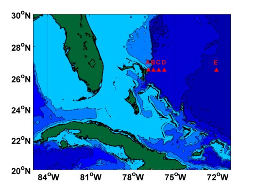
In September 2004 NOAA initiated a program to monitor the flow of the DWBC in near-real-time. This program uses moored inverted echo sounders, some of which are additionally equipped with bottom pressure gauges and deep current meters. Data from these instruments is acoustically downloaded by a passing research vessel about every six months without actually recovering the instruments. In May 2005 this line was extended to also capture the northward flow of the Antilles Current.
Locations of the inverted echo sounders
Data Activity or Cruise Information
Cruise
| Cruise Name | RB0408 |
| Departure Date | 2004-09-22 |
| Arrival Date | 2004-10-03 |
| Principal Scientist(s) | Christopher S Meinen (NOAA Atlantic Oceanographic and Meteorological Laboratory) |
| Ship | NOAA Ship Ronald H. Brown |
Complete Cruise Metadata Report is available here
Fixed Station Information
Fixed Station Information
| Station Name | Site C |
| Category | Offshore location |
| Latitude | 26° 30.09' N |
| Longitude | 76° 5.25' W |
| Water depth below MSL | 4766.0 m |
WBTS - Site C
Site C forms part of the Western Boundary Time Series (WBTS) Current Transport Time Series array. Inverted Echo Sounders, with optional pressure (PIES) and current sensors (C-PIES), have been deployed in the array since 2004. The site is nominally visited once a year to either acoustically telemeter the data or service the instruments.
If the instrument is not be recovered, any data obtained by telemetry are processed and made available.
Data coverage
The table below is a summary of the data collect at Site C.
| Year of deployment | Instrument type | Serial number | Deplyment cruise | Recovery cruise | Comments |
|---|---|---|---|---|---|
| 2004 | PIES | 50 | RB0408 | RB0504 | |
| 2005 | PIES | 72 | RB0504 | SJ1406 | |
| 2006 | PIES | 134 | SJ14-06 | CH0708 | |
| 2008 | C-PIES | 155 | CH0708 | Instrument lost, available data obtained through telemetry | |
| 2011 | PIES | 58 | KN200-4 | Instrument lost, no data available | |
| 2012 | PIES | 281 | EN517 | EN574 | |
| 2016 | PIES | 325 | EN574 |
Related Fixed Station activities are detailed in Appendix 1
BODC Quality Control Flags
The following single character qualifying flags may be associated with one or more individual parameters with a data cycle:
| Flag | Description |
|---|---|
| Blank | Unqualified |
| < | Below detection limit |
| > | In excess of quoted value |
| A | Taxonomic flag for affinis (aff.) |
| B | Beginning of CTD Down/Up Cast |
| C | Taxonomic flag for confer (cf.) |
| D | Thermometric depth |
| E | End of CTD Down/Up Cast |
| G | Non-taxonomic biological characteristic uncertainty |
| H | Extrapolated value |
| I | Taxonomic flag for single species (sp.) |
| K | Improbable value - unknown quality control source |
| L | Improbable value - originator's quality control |
| M | Improbable value - BODC quality control |
| N | Null value |
| O | Improbable value - user quality control |
| P | Trace/calm |
| Q | Indeterminate |
| R | Replacement value |
| S | Estimated value |
| T | Interpolated value |
| U | Uncalibrated |
| W | Control value |
| X | Excessive difference |
SeaDataNet Quality Control Flags
The following single character qualifying flags may be associated with one or more individual parameters with a data cycle:
| Flag | Description |
|---|---|
| 0 | no quality control |
| 1 | good value |
| 2 | probably good value |
| 3 | probably bad value |
| 4 | bad value |
| 5 | changed value |
| 6 | value below detection |
| 7 | value in excess |
| 8 | interpolated value |
| 9 | missing value |
| A | value phenomenon uncertain |
| B | nominal value |
| Q | value below limit of quantification |
Appendix 1: Site C
Related series for this Fixed Station are presented in the table below. Further information can be found by following the appropriate links.
If you are interested in these series, please be aware we offer a multiple file download service. Should your credentials be insufficient for automatic download, the service also offers a referral to our Enquiries Officer who may be able to negotiate access.
| Series Identifier | Data Category | Start date/time | Start position | Cruise |
|---|---|---|---|---|
| 1781406 | Inverted Echo Sounder Time Series | 2005-09-19 12:00:00 | 26.501 N, 76.087 W | NOAA Ship Ronald H. Brown RB0504 |
| 1781418 | Inverted Echo Sounder Time Series | 2006-10-07 12:00:00 | 26.501 N, 76.087 W | RV Seward Johnson SJ-14-06 |
| 1786158 | Inverted Echo Sounder Time Series | 2008-09-28 12:00:00 | 26.5015 N, 76.0875 W | RV Cape Hatteras CH0708 |
| 1781431 | Inverted Echo Sounder Time Series | 2012-10-05 12:00:00 | 26.5 N, 76.093 W | RV Endeavor EN517 |
