Metadata Report for BODC Series Reference Number 2211290
Metadata Summary
Problem Reports
Data Access Policy
Narrative Documents
Project Information
Data Activity or Cruise Information
Fixed Station Information
BODC Quality Flags
SeaDataNet Quality Flags
Metadata Summary
Data Description |
|||||||||||||||||||||||||||||||||||||
|
|||||||||||||||||||||||||||||||||||||
Data Identifiers |
|||||||||||||||||||||||||||||||||||||
|
|||||||||||||||||||||||||||||||||||||
Time Co-ordinates(UT) |
|||||||||||||||||||||||||||||||||||||
|
|||||||||||||||||||||||||||||||||||||
Spatial Co-ordinates | |||||||||||||||||||||||||||||||||||||
|
|||||||||||||||||||||||||||||||||||||
Parameters |
|||||||||||||||||||||||||||||||||||||
|
|||||||||||||||||||||||||||||||||||||
|
|||||||||||||||||||||||||||||||||||||
Problem Reports
No Problem Report Found in the Database
Data Access Policy
GEOTRACES - data access conditions
Access to this data is currently restricted and it is not available via BODC's normal delivery mechanisms.
GEOTRACES data are published via the GEOTRACES IDP, available at:
Narrative Documents
KM1107 CTD Instrumentation
The CTD was fitted with the following sensors:
| Sensor | Serial Number | Calibration Date | Comments |
|---|---|---|---|
| Conductivity, temperature and depth package | - | - | - |
Some information is unavailable.
CTD profiles for Cruise KM1107 (GPpr05)
Sampling Strategy
A total of 6 CTD casts were carried out during cruise KM1107, on board the Kilo Moana, using a Stainless Steel CTD frame equipped with 12 L Niskin bottles. The cruise surveyed GEOTRACES section GPpr05.
KM1107 Cruise report
Further information can be found in the KM1107 Cruise report.
BODC Data Processing Procedures
Data received were converted to the BODC internal format (a netCDF subset). A parameter mapping table is provided below:
| Originator's Variable | Originator's Units | BODC Parameter Code | BODC Units | GEOTRACES Code | GEOTRACES Units | Comments |
|---|---|---|---|---|---|---|
| oxy 2 | µmol/kg | DOXYUCKG | µmol/kg | CTDOXY_D_CONC_SENSOR | µmol/kg | - |
| transmission | % | ATTNZZ01 | % | CTDBEAMCP_T_VALUE_SENSOR | 1/m | - |
| pressure | decibar | PRESPR01 | decibar | CTDPRS_T_VALUE_SENSOR | decibar | - |
| temp | °C | TEMPST01 | °C | CTDTMP_T_VALUE_SENSOR | °C | - |
| sal | PSU | PSALST01 | dimensionless | CTDSAL_D_CONC_SENSOR | PSS-78 | Units are equivalent. |
| oxy 1 | µmol/kg | DOXMZZXX | µmol/kg | CTDOXY_D_CONC_SENSOR | µmol/kg | - |
| fluorescence | 0 | CPHLPR01 | mg/m3 | CTDCHLA_T_CONC_SENSOR | mg/m3 | - |
Following transfer the data were screened using BODC in-house visualisation software. Suspect data values were assigned the appropriate BODC data quality flag. Missing data values, where present, were changed to the missing data value and assigned a BODC data quality flag.
Data Quality Report
ATTNZZ01 was heavily flagged during processing as the channel contains improbable values.
Project Information
GEOTRACES
Introduction
GEOTRACES is an international programme sponsored by SCOR which aims to improve our understanding of biogeochemical cycles and large-scale distribution of trace elements and their isotopes (TEIs) in the marine environment. The global field programme started in 2009 and will run for at least a decade. Before the official launch of GEOTRACES, fieldwork was carried out as part of the International Polar Year (IPY)(2007-2009) where 14 cruises were connected to GEOTRACES.
GEOTRACES is expected to become the largest programme to focus on the chemistry of the oceans and will improve our understanding of past, present and future distributions of TEIs and their relationships to important global processes.
This initiative was prompted by the increasing recognition that TEIs are playing a crucial role as regulators and recorders of important biogeochemical and physical processes that control the structure and productivity of marine ecosystems, the dispersion of contaminants in the marine environment, the level of greenhouse gases in the atmosphere, and global climate.
Scientific Objectives
GEOTRACES mission is: To identify processes and quantify fluxes that control the distribution of key trace elements and isotopes in the ocean, and to establish the sensitivity of these distributions to changing environmental conditions.
Three overriding goals support the GEOTRACES mission
- Determine ocean distributions of selected TEIs at all major ocean basins
- Evaluate the sources, sinks, and internal cycling of these TEIs and thereby characterize more completely their global biogeochemical cycles
- Provide a baseline distribution in the Polar Regions as reference for assessing past and future changes.
These goals will be pursued through complementary research strategies, including observations, experiments and modelling.
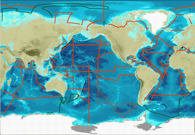
Fieldwork
The central component of GEOTRACES fieldwork will be a series of cruises spanning all Ocean basins see map below.
Three types of cruise are required to meet the goals set out by GEOTRACES. These are
- Section cruises - These will measure all the key parameters (see below) over the full depth of the water column. The sections were discussed and approved by the International GEOTRACES Scientific Steering Committee at the basin workshops.
- Process Studies - These will investigate a particular process relevant to the cycling of trace metal and isotopes. They must follow the "Criteria for Establishing GEOTRACES Process Studies" and be approved by the International GEOTRACES Scientific Steering Committee.
- Cruises collecting GEOTRACES compliant data - These will collect some trace element or isotope data. They must follow the GEOTRACES Intercalibration and Data Management protocols
IPY-GEOTRACES
The IPY-GEOTRACES programme comprised of 14 research cruises on ships from 7 nations; Australia, Canada, France, Germany, New Zealand, Japan and Russia. The cruises will not be classified in the same way as the full GEOTRACES programme since the intercalibration protocols and data management protocols had not been established before the start of the IPY. But IPY-GEOTRACES data will still be quality controlled by GDAC and in the majority of cases verified versus Intercalibration standards or protocols.
Key parameters
The key parameters as set out by the GEOTRACES science plan are as follows: Fe, Al, Zn, Mn, Cd, Cu; 15N, 13C; 230Th, 231Pa; Pb isotopes, Nd isotopes; stored sample, particles, aerosols.
Weblink:
http://www.bodc.ac.uk/geotraces/
http://www.geotraces.org/
Data Activity or Cruise Information
Cruise
| Cruise Name | KM1107 (GPpr05) |
| Departure Date | 2011-02-23 |
| Arrival Date | 2011-02-25 |
| Principal Scientist(s) | Katharina Pahnke (Institute for Chemistry and Biology Of The Marine Environment) |
| Ship | RV Kilo Moana |
Complete Cruise Metadata Report is available here
Fixed Station Information
No Fixed Station Information held for the Series
BODC Quality Control Flags
The following single character qualifying flags may be associated with one or more individual parameters with a data cycle:
| Flag | Description |
|---|---|
| Blank | Unqualified |
| < | Below detection limit |
| > | In excess of quoted value |
| A | Taxonomic flag for affinis (aff.) |
| B | Beginning of CTD Down/Up Cast |
| C | Taxonomic flag for confer (cf.) |
| D | Thermometric depth |
| E | End of CTD Down/Up Cast |
| G | Non-taxonomic biological characteristic uncertainty |
| H | Extrapolated value |
| I | Taxonomic flag for single species (sp.) |
| K | Improbable value - unknown quality control source |
| L | Improbable value - originator's quality control |
| M | Improbable value - BODC quality control |
| N | Null value |
| O | Improbable value - user quality control |
| P | Trace/calm |
| Q | Indeterminate |
| R | Replacement value |
| S | Estimated value |
| T | Interpolated value |
| U | Uncalibrated |
| W | Control value |
| X | Excessive difference |
SeaDataNet Quality Control Flags
The following single character qualifying flags may be associated with one or more individual parameters with a data cycle:
| Flag | Description |
|---|---|
| 0 | no quality control |
| 1 | good value |
| 2 | probably good value |
| 3 | probably bad value |
| 4 | bad value |
| 5 | changed value |
| 6 | value below detection |
| 7 | value in excess |
| 8 | interpolated value |
| 9 | missing value |
| A | value phenomenon uncertain |
| B | nominal value |
| Q | value below limit of quantification |
