Metadata Report for BODC Series Reference Number 29750
Metadata Summary
Problem Reports
Data Access Policy
Narrative Documents
Project Information
Data Activity or Cruise Information
Fixed Station Information
BODC Quality Flags
SeaDataNet Quality Flags
Metadata Summary
Data Description |
|||||||||||||||||||||||||||||||||
|
|||||||||||||||||||||||||||||||||
Data Identifiers |
|||||||||||||||||||||||||||||||||
|
|||||||||||||||||||||||||||||||||
Time Co-ordinates(UT) |
|||||||||||||||||||||||||||||||||
|
|||||||||||||||||||||||||||||||||
Spatial Co-ordinates | |||||||||||||||||||||||||||||||||
|
|||||||||||||||||||||||||||||||||
Parameters |
|||||||||||||||||||||||||||||||||
|
|||||||||||||||||||||||||||||||||
|
|||||||||||||||||||||||||||||||||
Problem Reports
The wave and swell directions given should be treated with caution.
The wave direction given is the wind direction taken from the meteorological log.
The swell direction given is the swell direction taken from the meteorological log.
Data Access Policy
Public domain data
These data have no specific confidentiality restrictions for users. However, users must acknowledge data sources as it is not ethical to publish data without proper attribution. Any publication or other output resulting from usage of the data should include an acknowledgment.
The recommended acknowledgment is
"This study uses data from the data source/organisation/programme, provided by the British Oceanographic Data Centre and funded by the funding body."
Narrative Documents
Data Document for Boyle Station Waverider Buoy
Instrumentation
Datawell waverider buoy transmitting to Warep receiver/recorder on board ship. Paper chart records of 15 minutes duration were made every 3 hours, starting 15 minutes before the hours of 00, 03, 06, 09, 12,15, 18 and 21. From 29 June 1974 onwards, backup recordings were made on analogue magnetic tape using a Geotech F.M. tape recorder. A second waverider buoy on trial for Esso Production Research Co. (EPR Co) was deployed in parallel with the Datawell buoy until January 1975; on occasions when the Datawell buoy was unable to transmit valid data, the EPR Co buoy was used to provide a backup system. Eight different Datawell buoys were used during the programme; serial numbers 6159, 6199, 6298, 6366, 6500, 6501, 6673 and 6679. When the ship temporarily left station during a sea trip, the buoy was often left on station.
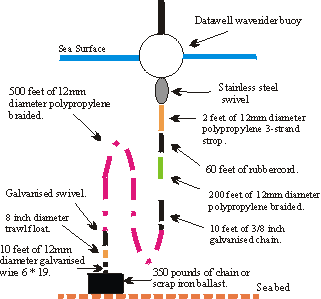
Waverider mooring configuration
Calibration
Equipment was checked by Marex engineers at the start of each trip. The waverider buoys were calibrated periodically by Datawell or by the National Maritime Institute, Feltham (see below), and since this resulted in their being within Datawell specification no corrections to the data for instrument errors were necessary.
Data Analysis
The chart records were analysed manually by the Tucker-Draper method (Draper L., The Analysis and Presentation of Wave Data - A Plea for Uniformity. Proc. 10th Coastal Engineering Conf., Tokyo, 1966, Vol. 1, pp 1-11, American Society of Civil Engineers, 1967) to derive values for significant wave height and mean zero upcrossing period. Where available, the analogue tape backup data were used to fill gaps in the chart record data.
Instrument History
| Trip | Period of Deployment | Buoy No. | Comments | |||
|---|---|---|---|---|---|---|
| From | To | |||||
| Hour | Date | Hour | Date | |||
| 1 | 0830 | 25 May 74 | - | 04 Jun 74 | 6366 | At 1757hr on 04 Jun 1974 buoy 6366 was taken by a trawler. It was returned later the same day, but the spare buoy (6298) was deployed in case damage had occurred. The EPR Co buoy was used until deployment of 6298. Buoy 6366 was checked in Falmouth at the end of the trip. |
| - | 10 Jun 74 | 2100 | 22 Jun 74 | 6298 | ||
| 1907 | 26 May 74 | 2000 | 22 Jun 74 | EPR Co | ||
| 2 | 0610 | 29 Jun 74 | 1200 | 18 Jul 74 | 6366 | Buoy 6366 checked at end of trip. |
| 0625 | 29 Jun 74 | 1035 | 18 Jul 74 | EPR Co | ||
| 3 | 1417 | 20 Jul 74 | 1310 | 18 Aug 74 | 6355 | EPR Co buoy and current meters drifted together on 23 Jul 74. |
| 1430 | 20 Jul 74 | 0800 | 23 Jul 74 | EPR Co | ||
| 1640 | 23 Jul 74 | 1450 | 18 Aug 74 | EPR Co | ||
| 4 | 0933 | 20 Aug 74 | 1005 | 18 Sep 74 | 6366 | Buoy 6366 did not respond correctly to waves over 5 metres. |
| 0945 | 20 Aug 74 | 0930 | 18 Sep 74 | EPR Co | ||
| 5 | 1055 | 24 Sep 74 | 1527 | 24 Sep 74 | 6366 | Buoy 6366 changed on instructions from Marex and returned to Datawell for repair. |
| 1527 | 24 Sep 74 | 1035 | 19 Oct 74 | 6298 | ||
| 1115 | 24 Sep 74 | 1120 | 19 Oct 74 | EPR Co | ||
| 6 | 0935 | 25 Oct 74 | 1015 | 17 Nov 74 | 6298 | EPR Co buoy mooring snapped on 09 Nov 74; buoy recovered same day.No information available on characteristics or function of SPAR buoy. |
| 0950 | 25 Oct 74 | 1115 | 09 Nov 74 | EPR Co | ||
| 1600 | 12 Nov 74 | 0855 | 17 Nov 74 | EPR Co | ||
| 1245 | 25 Oct 74 | 1400 | 16 Nov 74 | SPAR | ||
| 7 | 1010 | 21 Nov 74 | 1800 | 30 Nov 74 | 6298 | Buoy 6298 taken by trawler on 30 Nov 74; buoy not recovered. Buoy 6366 not available for deployment until 06 Dec 74. On 27 Nov 74 the EPR Co buoy transmitter burned out; returned to Marex for repair at end of trip. |
| 1329 | 06 Dec 74 | 1313 | 15 Dec 74 | 6366 | ||
| 1018 | 21 Nov 74 | 1557 | 14 Dec 74 | EPR Co | ||
| 8 | 1045 | 20 Dec 74 | 0900 | 14 Jan 75 | 6366 | On 20 Dec 74 parts of the wave trace were missing. System checked in Falmouth at end of trip. |
| 9 | 1007 | 18 Jan 75 | 1445 | 14 Feb 75 | EPR Co | On 20 Jan 75 at 1140hr the EPR Co buoy showed a very erratic trace. At 1445hrs on 27 Jan 75 buoy 6366 went off lock and is believed to have sunk; buoy not recovered. Only 2 days data collected this trip. EPR Co buoy returned to Datawell for repair at end of trip. |
| 1120 | 20 Jan 75 | 1405 | 21 Jan 75 | 6366 | ||
| 1415 | 25 Jan 75 | - | - | 6366 | ||
| 10 | 0935 | 20 Feb 75 | 0900 | 07 Mar 75 | 6500 | Buoy showing off lock at 1430hrs on 03 Mar 75. Buoy drifting at 0735hrs on 07 Mar 75, its line having been cut; recovered and redeployed. System checked in Falmouth at end of trip. |
| 1635 | 07 Mar 75 | 0830 | 18 Mar 75 | 6500 | ||
| 11 | 1117 | 20 Mar 75 | 16 Apr 75 | 6500 | Several reruns of samples had to be made this trip as the first samples were not very good. System checked in Falmouth at end of trip. | |
| 12 | 0940 | 20 Apr 75 | 1445 | 17 May 75 | 6500 | System checked in Penzance at end of trip. |
| 13 | 1053 | 20 May 75 | 0455 | 15 Jan 75 | 6500 | Voice interference on signal from 23 May 75 to 01 Jun 75; sample periods extended to compensate, so no data lost. Warep trace off lock several times during trip. System checked in Penzance at end of trip. |
| 14 | 1020 | 17 Jun 75 | 1418 | 13 Jul 75 | 6500 | Problems with Warep pen on several occasions. System checked in Penzance at end of trip. |
| 15 | 1130 | 16 Jul 75 | 0650 | 13 Aug 75 | 6500 | |
| 16 | 1021 | 16 Aug 75 | 0832 | 15 Sep 75 | 6500 | Problems were experienced when the buoy was on the port quarter. |
| 17 | 0855 | 19 Sep 75 | 2030 | 28 Sep 75 | 6500 | 5 days data lost (26 Sep 75 to 01 Oct 75) because of pen problems. Buoy mooring cut by trawler on 28 Sep 75; redeploy- ment delayed by bad weather. |
| 1245 | 30 Sep 75 | 0630 | 15 Oct 75 | 6500 | ||
| 18 | 0829 | 18 Oct 75 | 1342 | 15 Nov 75 | 6501 | Many reruns this trip as Warep pen kept sticking. |
| 19 | 1155 | 19 Nov 75 | 0545 | 16 Dec 75 | 6501 | |
| 20 | 0920 | 19 Dec 75 | - | 08 Jan 76 | 6501 | Buoy 6501 lost on 08 Jan 76 at 2118hrs; recovered on 15 Jan 76. |
| 1445 | 09 Jan 76 | 1018 | 13 Jan 76 | 6199 | ||
| 21 | 1200 | 15 Jan 76 | 0710 | 10 Feb 76 | 6199 | Between 14 Jan 76 and 10 Feb 76 there was inter- mittent unlocking of the Warep. Buoy 6501 returned to Datawell for repair. |
| 22 | 1111 | 14 Feb 76 | 1406 | 18 Feb 76 | 6199 | Buoy 6199 recovered due 1412 18 Feb 76 1531 08 Mar 76 6679 to fluctuations on wave trace. Buoy 6199 returned for investigation. |
| 23 | 1849 | 12 Mar 76 | 0600 | 06 Apr 76 | 6679 | |
| 24 | 1347 | 10 Apr 76 | 1206 | 04 May 76 | 6679 | |
| 25 | 1300 | 07 May 76 | 0700 | 01 Jun 76 | 6679 | |
| 26 | 0950 | 04 Jun 76 | 1223 | 29 Jun 76 | 6679 | |
| 27 | 0840 | 03 Jul 76 | 0615 | 27 Jul 76 | 6679 | |
| 28 | 0940 | 30 Jul 76 | 1052 | 24 Aug 76 | 6679 | |
| 29 | 0620 | 27 Aug 76 | 0510 | 21 Sep 76 | 6679 | All data between Sep 76 and Feb 77 should be treated with caution as problems were experienced with the waverider buoy system (wandering zero, squared off peaks and troughs and uncharacter- istic wave profile). |
| 30 | 0752 | 23 Sep 76 | 1218 | 18 Oct 76 | 6679 | See note for trip 29. Buoy 6679 returned for calibration. |
| 31 | 1005 | 23 Oct 76 | 0835 | 16 Nov 76 | 6159 | See note for trip 29. Buoy 6501 returned for calibration. |
| 32 | 0941 | 19 Nov 76 | 1253 | 10 Dec 76 | 6159 | See note for trip 29. 1355 10 Dec 75 1355 14 Dec 76 6199 Buoy 6159 replaced by buoy 6199 to try to cure a wandering zero, but the problem still persisted. The Warep receiver/recorder was replaced by a new unit, the old one being re- moved for investigation, repair and calibration. |
| 33 | 1130 | 17 Dec 76 | 0445 | 11 Jan 77 | 6159 | See note for trip 29. |
| 34 | 0959 | 16 Jan 77 | 0335 | 08 Feb 77 | 6159 | See note for trip 29. Buoy 6199 returned for calibration. |
| 35 | 1126 | 11 Feb 77 | 0235 | 08 Mar 77 | 6673 | |
| 36 | 1330 | 11 Mar 77 | 1801 | 04 Apr 77 | 6673 | |
| 37 | 0930 | 08 Apr 77 | - | 01 May 77 | 6673 | Buoy 6673 lost to a trawler, spare buoy deployed. |
| 0925 | 02 May 77 | 0550 | 03 May 77 | 6501 | ||
| 38 | 0714 | 06 May 77 | 1338 | 31 May 77 | 6501 | Several reruns this trip due to pen problems and chart jamming. Buoy 6501 returned for calibration. |
Quality Control Procedures
Marex Quality Control
Initial quality control was performed by Marex during the initial preparation and processing of the data. Dubious values identified at this stage were deleted, or replaced by more reliable data from the backup magnetic tape where available. No details of the quality control procedures applied by Marex are available.
MPS Quality Control
Additional quality control was performed by Meteorological and Plotting Services (MPS) Oceanic Limited, Bushey Heath. Records were identified in which:
-
Significant or 3 hour maximum wave height varied by more than 50 per cent between successive records.
-
Significant wave height exceeded 5 metres in summer, 7 metres in winter.
-
Maximum wave height (3 hours) exceeded 10 metres in summer, 14 metres in winter.
-
Mean zero upcrossing wave period exceed 10 seconds in summer, 12 seconds in winter.
-
Unusual variations in mean zero upcrossing wave period were identified by visual examination of the data values.
Values identified by these tests were checked against the corresponding shipborne wave recorder values. Sample checks were also made back to the raw data. Where the analysis was found to be erroneous, replacement values were generated from the original record. If the original record was found to be suspect, the quality control flag has been set to L.
BODC Quality Control
Further quality control was performed by BODC when the data were banked. Records which failed the following tests were examined in detail in the context of the time series of data as a whole:
-
If significant wave height changed by more than 3 metres between successive records, then it must not change by more than 1.5 metres on the following record.
-
If mean zero upcrossing wave period changed by more than 3 seconds between successive records, then it must not change by more than 1.5 seconds on the following record.
-
The ratio of significant wave height recorded by waverider buoy to that recorded by shipborne wave recorder at a given time should be within the range 0.5 to 2.0, and the absolute difference should not exceed 2.5 metres.
-
The ratio of mean zero upcrossing wave period recorded by waverider buoy to that recorded by shipborne wave recorder should be within the range 0.5 to 2.0, and the absolute difference should not exceed 3 seconds.
Two dimensional frequency distributions were plotted of:
-
Significant wave height versus mean zero upcrossing wave period for waverider buoy data and also for shipborne wave recorder data.
-
Significant wave height recorded by the waverider buoy versus that from the shipborne wave recorder.
-
Mean zero upcrossing wave period from the waverider buoy versus that from the shipborne wave recorder.
Extreme values on the periphery of these plots were also examined in detail in the context of the time series of data as a whole. Values identified as dubious by BODC screening procedures are flagged M.
Project Information
No Project Information held for the Series
Data Activity or Cruise Information
No Data Activity or Cruise Information held for the Series
Fixed Station Information
Fixed Station Information
| Station Name | Boyle |
| Category | Offshore location |
| Latitude | 50° 40.00' N |
| Longitude | 7° 30.00' W |
| Water depth below MSL | 107.0 m |
Boyle Station Site History
Site
The Boyle Station (50.7° N, 007.5° W) is sited in the Celtic Sea approximately mid-way between Lands End in England and Cape Clear at the southernmost tip of Ireland, in a water depth of 107 metres. It was occupied from 24 May 1974 to 01 June 1977, initially on behalf of the Celtic Sea Oceanographic Study Group (CSOSG) and later (from mid 1975) for the Oceanographic Committee of the United Kingdom Offshore Operators Association (UKOOA). The main aim of the data collection programme was to study the environmental climate for purposes of offshore operations.
Data Collection and Processing
Data collection and processing was performed by Marine Exploration Limited (MAREX), Isle of Wight.
The data collection programme included:
- Wave data collected at 3 hourly intervals by means of a shipborne wave recorder and a moored waverider buoy.
- Instrumentally measured wind data collected at hourly intervals.
- Meteorological synoptic observations made at 3 hourly intervals.
- Current meter data collected at 10 minute intervals at three different depths.
- Bathythermograph data collected several times a month (these data were sent to the Hydrographic Department MOD (Navy), Taunton).
The data collection programme was centred about a ship on station for periods of up to 1 month at a time. Gaps of up to a week appear in the data at the end of each on-station period. A total of 38 sea trips was made during the programme, the merchant vessel Skagerak being used throughout.
On Station History
| Period on Station | Temporary Absence from Station | |||||||
|---|---|---|---|---|---|---|---|---|
| From | To | From | To | |||||
| Trip No. | Hour | Date | Hour | Date | Hour | Date | Hour | Date |
| 1 | 1000 | 24 May 74 | 1800 | 24 Jun 74 | 2000 | 06 Jun 74 | 0400 | 08 Jun 74 |
| 2 | 0500 | 29 Jun 74 | 1900 | 18 Jul 74 | ||||
| 3 | 1010 | 20 Jul 74 | 1816 | 18 Aug 74 | 0100 | 26 Jul 74 | 0005 | 27 Jul 74 |
| 4 | 0800 | 20 Aug 74 | 1200 | 18 Sep 74 | ||||
| 5 | 0700 | 23 Sep 74 | 1906 | 20 Oct 74 | 0015 | 28 Sep 74 | 0600 | 29 Sep 74 |
| 6 | 0900 | 25 Oct 74 | 1200 | 17 Nov 74 | ||||
| 7 | 0230 | 21 Nov 74 | 1930 | 15 Dec 74 | 0302 | 05 Dec 74 | 0732 | 06 Dec 74 |
| 8 | 1015 | 20 Dec 74 | 0600 | 15 Jan 75 | ||||
| 9 | 2339 | 17 Jan 75 | 2100 | 16 Feb 75 | 0017 | 24 Jan 75 | 0001 | 25 Jan 75 |
| 10 | 1930 | 19 Feb 75 | 1700 | 18 Mar 75 | 0000 | 04 Mar 75 | 0200 | 05 Mar 75 |
| 11 | 1030 | 20 Mar 75 | 1850 | 16 Apr 75 | ||||
| 12 | 0900 | 20 Apr 75 | 1800 | 18 May 75 | ||||
| 13 | 0850 | 20 May 75 | 1800 | 15 Jun 75 | 1830 | 01 Jun 75 | 0510 | 03 Jun 75 |
| 14 | 0818 | 17 Jun 75 | 1800 | 13 Jul 75 | ||||
| 15 | 2145 | 15 Jul 75 | 1800 | 13 Aug 75 | ||||
| 16 | 1020 | 16 Aug 75 | 0900 | 15 Sep 75 | ||||
| 17 | 0700 | 19 Sep 75 | 1800 | 15 Oct 75 | ||||
| 18 | 0045 | 18 Oct 75 | 1500 | 16 Nov 75 | 0910 | 11 Nov 75 | 0734 | 12 Nov 75 |
| 19 | 1115 | 19 Nov 75 | 1800 | 16 Dec 75 | ||||
| 20 | 0350 | 19 Dec 75 | 1815 | 13 Jan 76 | ||||
| 21 | 1200 | 15 Jan 76 | 1800 | 10 Feb 75 | 1800 | 20 Jan 76 | 0430 | 22 Jan 76 |
| 22 | 2350 | 13 Feb 75 | 1530 | 09 Mar 76 | 1905 | 19 Feb 75 | 0230 | 21 Feb 76 |
| 23 | 1200 | 12 Mar 76 | 1820 | 07 Apr 76 | 0305 | 17 Mar 76 | 0610 | 18 Mar 76 |
| 24 | 1305 | 10 Apr 75 | 1822 | 04 May 76 | ||||
| 25 | 1215 | 07 May 76 | 1800 | 01 Jun 76 | ||||
| 26 | 0728 | 04 Jun 76 | 1830 | 29 Jun 76 | ||||
| 27 | 0750 | 03 Jul 76 | 1800 | 27 Jul 76 | ||||
| 28 | 0530 | 30 Jul 76 | 1505 | 24 Aug 76 | ||||
| 29 | 0543 | 27 Aug 76 | 1525 | 21 Sep 76 | 2100 | 14 Sep 76 | 2300 | 15 Sep 76 |
| 30 | 0445 | 23 Sep 76 | 1200 | 19 Oct 76 | ||||
| 31 | 0620 | 23 Oct 76 | 1210 | 16 Nov 76 | ||||
| 32 | 0205 | 19 Nov 76 | 2110 | 14 Dec 76 | ||||
| 33 | 1125 | 17 Dec 76 | 2100 | 11 Jan 77 | ||||
| 34 | 2230 | 13 Jan 77 | 1855 | 08 Feb 77 | ||||
| 35 | 1050 | 11 Feb 77 | 1800 | 08 Mar 77 | ||||
| 36 | 1710 | 10 Mar 77 | 1525 | 05 Apr 77 | ||||
| 37 | 0845 | 08 Apr 77 | 1526 | 03 May 77 | 0001 | 14 Apr 77 | 0001 | 15 Apr 77 |
| 38 | 0535 | 06 May 77 | 0010 | 01 Jun 77 | 0337 | 11 May 77 | 0350 | 12 May 77 |
| 0015 | 17 May 77 | 0420 | 18 May 77 | |||||
Note: Because the waverider buoy and current meters were deployed just before the ship took station, and were recovered after the ship left station, the period covered by data from these instruments may extend up to 1 day beyond the start and end times of the on station periods given in the above table.
Related Fixed Station activities are detailed in Appendix 1
BODC Quality Control Flags
The following single character qualifying flags may be associated with one or more individual parameters with a data cycle:
| Flag | Description |
|---|---|
| Blank | Unqualified |
| < | Below detection limit |
| > | In excess of quoted value |
| A | Taxonomic flag for affinis (aff.) |
| B | Beginning of CTD Down/Up Cast |
| C | Taxonomic flag for confer (cf.) |
| D | Thermometric depth |
| E | End of CTD Down/Up Cast |
| G | Non-taxonomic biological characteristic uncertainty |
| H | Extrapolated value |
| I | Taxonomic flag for single species (sp.) |
| K | Improbable value - unknown quality control source |
| L | Improbable value - originator's quality control |
| M | Improbable value - BODC quality control |
| N | Null value |
| O | Improbable value - user quality control |
| P | Trace/calm |
| Q | Indeterminate |
| R | Replacement value |
| S | Estimated value |
| T | Interpolated value |
| U | Uncalibrated |
| W | Control value |
| X | Excessive difference |
SeaDataNet Quality Control Flags
The following single character qualifying flags may be associated with one or more individual parameters with a data cycle:
| Flag | Description |
|---|---|
| 0 | no quality control |
| 1 | good value |
| 2 | probably good value |
| 3 | probably bad value |
| 4 | bad value |
| 5 | changed value |
| 6 | value below detection |
| 7 | value in excess |
| 8 | interpolated value |
| 9 | missing value |
| A | value phenomenon uncertain |
| B | nominal value |
| Q | value below limit of quantification |
Appendix 1: Boyle
Related series for this Fixed Station are presented in the table below. Further information can be found by following the appropriate links.
If you are interested in these series, please be aware we offer a multiple file download service. Should your credentials be insufficient for automatic download, the service also offers a referral to our Enquiries Officer who may be able to negotiate access.
| Series Identifier | Data Category | Start date/time | Start position | Cruise |
|---|---|---|---|---|
| 29670 | Waves (statistics) | 1974-05-24 12:00:00 | 50.6666 N, 7.5 W | Not applicable |
| 694516 | Waves (statistics) | 1974-05-24 12:00:00 | 50.683 N, 7.5 W | Not applicable |
| 30093 | Winds -statistics | 1974-05-24 13:00:00 | 50.6666 N, 7.5 W | Not applicable |
| 694504 | Waves (statistics) | 1974-05-25 09:00:00 | 50.683 N, 7.5 W | Not applicable |
| 4873 | Currents -subsurface Eulerian | 1974-05-25 18:55:00 | 50.6666 N, 7.5 W | Not applicable |
| 29725 | Waves (statistics) | 1974-05-26 12:00:00 | 50.6666 N, 7.5 W | Not applicable |
| 4861 | Currents -subsurface Eulerian | 1974-05-26 19:38:00 | 50.6666 N, 7.5 W | Not applicable |
| 4885 | Currents -subsurface Eulerian | 1974-06-29 08:03:00 | 50.6666 N, 7.5 W | Not applicable |
| 29368 | Currents -subsurface Eulerian | 1974-06-29 08:03:00 | 50.6666 N, 7.5 W | Not applicable |
| 29381 | Currents -subsurface Eulerian | 1974-06-29 09:25:00 | 50.6666 N, 7.5 W | Not applicable |
| 4897 | Currents -subsurface Eulerian | 1974-07-21 10:18:00 | 50.6666 N, 7.5 W | Not applicable |
| 4916 | Currents -subsurface Eulerian | 1974-08-21 11:28:00 | 50.6666 N, 7.5 W | Not applicable |
| 4904 | Currents -subsurface Eulerian | 1974-08-21 11:29:00 | 50.6666 N, 7.5 W | Not applicable |
| 4928 | Currents -subsurface Eulerian | 1974-09-24 13:37:00 | 50.6666 N, 7.5 W | Not applicable |
| 4941 | Currents -subsurface Eulerian | 1974-10-25 10:38:00 | 50.6666 N, 7.5 W | Not applicable |
| 4953 | Currents -subsurface Eulerian | 1974-10-25 10:40:00 | 50.6666 N, 7.5 W | Not applicable |
| 4965 | Currents -subsurface Eulerian | 1974-10-25 11:16:00 | 50.6666 N, 7.5 W | Not applicable |
| 4977 | Currents -subsurface Eulerian | 1974-11-21 10:59:00 | 50.6666 N, 7.5 W | Not applicable |
| 4989 | Currents -subsurface Eulerian | 1974-12-07 13:59:00 | 50.6666 N, 7.5 W | Not applicable |
| 4990 | Currents -subsurface Eulerian | 1974-12-20 11:45:00 | 50.6666 N, 7.5 W | Not applicable |
| 5004 | Currents -subsurface Eulerian | 1974-12-20 11:45:00 | 50.6666 N, 7.5 W | Not applicable |
| 29682 | Waves (statistics) | 1975-01-01 00:00:00 | 50.6666 N, 7.5 W | Not applicable |
| 29737 | Waves (statistics) | 1975-01-01 00:00:00 | 50.6666 N, 7.5 W | Not applicable |
| 30100 | Winds -statistics | 1975-01-01 00:00:00 | 50.6666 N, 7.5 W | Not applicable |
| 5016 | Currents -subsurface Eulerian | 1975-01-21 14:48:00 | 50.6666 N, 7.5 W | Not applicable |
| 5028 | Currents -subsurface Eulerian | 1975-01-21 14:49:00 | 50.6666 N, 7.5 W | Not applicable |
| 5041 | Currents -subsurface Eulerian | 1975-01-21 15:09:00 | 50.6666 N, 7.5 W | Not applicable |
| 5053 | Currents -subsurface Eulerian | 1975-02-20 10:27:00 | 50.6666 N, 7.5 W | Not applicable |
| 5065 | Currents -subsurface Eulerian | 1975-02-20 10:27:00 | 50.6666 N, 7.5 W | Not applicable |
| 5077 | Currents -subsurface Eulerian | 1975-02-20 10:55:00 | 50.6666 N, 7.5 W | Not applicable |
| 5089 | Currents -subsurface Eulerian | 1975-03-20 11:38:00 | 50.6666 N, 7.5 W | Not applicable |
| 5090 | Currents -subsurface Eulerian | 1975-03-20 11:38:00 | 50.6666 N, 7.5 W | Not applicable |
| 5108 | Currents -subsurface Eulerian | 1975-04-20 10:05:00 | 50.6666 N, 7.5 W | Not applicable |
| 29694 | Waves (statistics) | 1975-05-20 09:00:00 | 50.6666 N, 7.5 W | Not applicable |
| 5121 | Currents -subsurface Eulerian | 1975-05-20 16:26:00 | 50.6666 N, 7.5 W | Not applicable |
| 5157 | Currents -subsurface Eulerian | 1975-06-17 10:16:00 | 50.6666 N, 7.5 W | Not applicable |
| 5133 | Currents -subsurface Eulerian | 1975-06-17 19:12:00 | 50.6666 N, 7.5 W | Not applicable |
| 5145 | Currents -subsurface Eulerian | 1975-06-17 19:12:00 | 50.6666 N, 7.5 W | Not applicable |
| 5169 | Currents -subsurface Eulerian | 1975-07-16 13:30:00 | 50.6666 N, 7.5 W | Not applicable |
| 5170 | Currents -subsurface Eulerian | 1975-07-16 13:30:00 | 50.6666 N, 7.5 W | Not applicable |
| 5182 | Currents -subsurface Eulerian | 1975-07-16 14:30:00 | 50.6666 N, 7.5 W | Not applicable |
| 5194 | Currents -subsurface Eulerian | 1975-08-16 10:49:00 | 50.6666 N, 7.5 W | Not applicable |
| 5201 | Currents -subsurface Eulerian | 1975-08-16 11:10:00 | 50.6666 N, 7.5 W | Not applicable |
| 5213 | Currents -subsurface Eulerian | 1975-08-16 11:10:00 | 50.6666 N, 7.5 W | Not applicable |
| 17816 | Currents -subsurface Eulerian | 1975-10-18 17:03:00 | 50.6666 N, 7.5 W | Not applicable |
| 17828 | Currents -subsurface Eulerian | 1975-10-18 17:24:00 | 50.6666 N, 7.5 W | Not applicable |
| 17841 | Currents -subsurface Eulerian | 1975-10-18 17:24:00 | 50.6666 N, 7.5 W | Not applicable |
| 17853 | Currents -subsurface Eulerian | 1975-11-19 14:35:00 | 50.6666 N, 7.5 W | Not applicable |
| 17865 | Currents -subsurface Eulerian | 1975-11-19 14:35:00 | 50.6666 N, 7.5 W | Not applicable |
| 17970 | Currents -subsurface Eulerian | 1975-12-19 12:06:00 | 50.6666 N, 7.5 W | Not applicable |
| 18021 | Currents -subsurface Eulerian | 1975-12-19 12:13:00 | 50.6666 N, 7.5 W | Not applicable |
| 29701 | Waves (statistics) | 1976-01-01 00:00:00 | 50.6666 N, 7.5 W | Not applicable |
| 29749 | Waves (statistics) | 1976-01-01 00:00:00 | 50.6666 N, 7.5 W | Not applicable |
| 30112 | Winds -statistics | 1976-01-01 00:00:00 | 50.6666 N, 7.5 W | Not applicable |
| 17982 | Currents -subsurface Eulerian | 1976-01-06 14:34:00 | 50.6666 N, 7.5 W | Not applicable |
| 18033 | Currents -subsurface Eulerian | 1976-01-06 14:39:00 | 50.6666 N, 7.5 W | Not applicable |
| 17877 | Currents -subsurface Eulerian | 1976-01-15 13:40:00 | 50.6666 N, 7.5 W | Not applicable |
| 17890 | Currents -subsurface Eulerian | 1976-01-15 13:45:00 | 50.6666 N, 7.5 W | Not applicable |
| 17994 | Currents -subsurface Eulerian | 1976-01-15 14:20:00 | 50.6666 N, 7.5 W | Not applicable |
| 17889 | Currents -subsurface Eulerian | 1976-02-01 14:16:00 | 50.6666 N, 7.5 W | Not applicable |
| 17908 | Currents -subsurface Eulerian | 1976-02-01 14:31:00 | 50.6666 N, 7.5 W | Not applicable |
| 18008 | Currents -subsurface Eulerian | 1976-02-01 14:50:00 | 50.6666 N, 7.5 W | Not applicable |
| 17921 | Currents -subsurface Eulerian | 1976-02-14 11:48:00 | 50.6666 N, 7.5 W | Not applicable |
| 17933 | Currents -subsurface Eulerian | 1976-02-14 12:05:00 | 50.6666 N, 7.5 W | Not applicable |
| 17969 | Currents -subsurface Eulerian | 1976-03-13 16:01:00 | 50.6666 N, 7.5 W | Not applicable |
| 17945 | Currents -subsurface Eulerian | 1976-03-14 11:20:00 | 50.6666 N, 7.5 W | Not applicable |
| 17957 | Currents -subsurface Eulerian | 1976-03-14 11:20:00 | 50.6666 N, 7.5 W | Not applicable |
| 18057 | Currents -subsurface Eulerian | 1976-04-10 14:02:00 | 50.6666 N, 7.5 W | Not applicable |
| 18069 | Currents -subsurface Eulerian | 1976-04-10 14:02:00 | 50.6666 N, 7.5 W | Not applicable |
| 18045 | Currents -subsurface Eulerian | 1976-04-10 14:16:00 | 50.6666 N, 7.5 W | Not applicable |
| 18070 | Currents -subsurface Eulerian | 1976-05-07 13:43:00 | 50.6666 N, 7.5 W | Not applicable |
| 18082 | Currents -subsurface Eulerian | 1976-05-07 13:59:00 | 50.6666 N, 7.5 W | Not applicable |
| 18101 | Currents -subsurface Eulerian | 1976-06-04 09:56:00 | 50.6666 N, 7.5 W | Not applicable |
| 18094 | Currents -subsurface Eulerian | 1976-06-04 10:01:00 | 50.6666 N, 7.5 W | Not applicable |
| 18113 | Currents -subsurface Eulerian | 1976-06-04 10:19:00 | 50.6666 N, 7.5 W | Not applicable |
| 18125 | Currents -subsurface Eulerian | 1976-07-03 09:33:00 | 50.6666 N, 7.5 W | Not applicable |
| 18149 | Currents -subsurface Eulerian | 1976-07-03 09:46:00 | 50.6666 N, 7.5 W | Not applicable |
| 18137 | Currents -subsurface Eulerian | 1976-07-03 10:35:00 | 50.6666 N, 7.5 W | Not applicable |
| 18174 | Currents -subsurface Eulerian | 1976-07-30 09:25:00 | 50.6666 N, 7.5 W | Not applicable |
| 18162 | Currents -subsurface Eulerian | 1976-07-30 09:45:00 | 50.6666 N, 7.5 W | Not applicable |
| 18150 | Currents -subsurface Eulerian | 1976-07-30 10:20:00 | 50.6666 N, 7.5 W | Not applicable |
| 18186 | Currents -subsurface Eulerian | 1976-08-27 07:05:00 | 50.6666 N, 7.5 W | Not applicable |
| 18217 | Currents -subsurface Eulerian | 1976-08-27 07:05:00 | 50.6666 N, 7.5 W | Not applicable |
| 18198 | Currents -subsurface Eulerian | 1976-08-27 07:34:00 | 50.6666 N, 7.5 W | Not applicable |
| 18230 | Currents -subsurface Eulerian | 1976-09-25 11:00:00 | 50.6666 N, 7.5 W | Not applicable |
| 18205 | Currents -subsurface Eulerian | 1976-09-25 11:05:00 | 50.6666 N, 7.5 W | Not applicable |
| 18229 | Currents -subsurface Eulerian | 1976-09-25 11:33:00 | 50.6666 N, 7.5 W | Not applicable |
| 18242 | Currents -subsurface Eulerian | 1976-10-23 11:25:00 | 50.6666 N, 7.5 W | Not applicable |
| 18254 | Currents -subsurface Eulerian | 1976-10-23 11:25:00 | 50.6666 N, 7.5 W | Not applicable |
| 18266 | Currents -subsurface Eulerian | 1976-11-19 10:12:00 | 50.6666 N, 7.5 W | Not applicable |
| 18291 | Currents -subsurface Eulerian | 1976-11-19 10:12:00 | 50.6666 N, 7.5 W | Not applicable |
| 18278 | Currents -subsurface Eulerian | 1976-11-19 10:51:00 | 50.6666 N, 7.5 W | Not applicable |
| 18310 | Currents -subsurface Eulerian | 1976-12-17 13:22:00 | 50.6666 N, 7.5 W | Not applicable |
| 18309 | Currents -subsurface Eulerian | 1976-12-17 13:32:00 | 50.6666 N, 7.5 W | Not applicable |
| 29713 | Waves (statistics) | 1977-01-01 00:00:00 | 50.6666 N, 7.5 W | Not applicable |
| 30124 | Winds -statistics | 1977-01-01 00:00:00 | 50.6666 N, 7.5 W | Not applicable |
| 18334 | Currents -subsurface Eulerian | 1977-01-16 10:09:00 | 50.6666 N, 7.5 W | Not applicable |
| 18346 | Currents -subsurface Eulerian | 1977-01-16 10:09:00 | 50.6666 N, 7.5 W | Not applicable |
| 18322 | Currents -subsurface Eulerian | 1977-01-16 10:47:00 | 50.6666 N, 7.5 W | Not applicable |
| 18371 | Currents -subsurface Eulerian | 1977-02-11 12:30:00 | 50.6666 N, 7.5 W | Not applicable |
| 18358 | Currents -subsurface Eulerian | 1977-02-11 12:35:00 | 50.6666 N, 7.5 W | Not applicable |
| 18395 | Currents -subsurface Eulerian | 1977-03-11 14:22:00 | 50.6666 N, 7.5 W | Not applicable |
| 18383 | Currents -subsurface Eulerian | 1977-03-11 14:48:00 | 50.6666 N, 7.5 W | Not applicable |
| 18402 | Currents -subsurface Eulerian | 1977-04-08 10:35:00 | 50.6666 N, 7.5 W | Not applicable |
| 18414 | Currents -subsurface Eulerian | 1977-04-08 10:45:00 | 50.6666 N, 7.5 W | Not applicable |
| 18438 | Currents -subsurface Eulerian | 1977-05-06 07:35:00 | 50.6666 N, 7.5 W | Not applicable |
| 18426 | Currents -subsurface Eulerian | 1977-05-06 07:40:00 | 50.6666 N, 7.5 W | Not applicable |
