Metadata Report for BODC Series Reference Number 50672
Metadata Summary
Problem Reports
Data Access Policy
Narrative Documents
Project Information
Data Activity or Cruise Information
Fixed Station Information
BODC Quality Flags
SeaDataNet Quality Flags
Metadata Summary
Data Description |
|||||||||||||||||||||||||
|
|||||||||||||||||||||||||
Data Identifiers |
|||||||||||||||||||||||||
|
|||||||||||||||||||||||||
Time Co-ordinates(UT) |
|||||||||||||||||||||||||
|
|||||||||||||||||||||||||
Spatial Co-ordinates | |||||||||||||||||||||||||
|
|||||||||||||||||||||||||
Parameters |
|||||||||||||||||||||||||
|
|||||||||||||||||||||||||
|
|||||||||||||||||||||||||
Problem Reports
No Problem Report Found in the Database
Data Access Policy
Public domain data
These data have no specific confidentiality restrictions for users. However, users must acknowledge data sources as it is not ethical to publish data without proper attribution. Any publication or other output resulting from usage of the data should include an acknowledgment.
The recommended acknowledgment is
"This study uses data from the data source/organisation/programme, provided by the British Oceanographic Data Centre and funded by the funding body."
Narrative Documents
Munro Float Tide Gauge
The Munro gauge measures the sea level by means of a float in a stilling well. The float is about 45cm diameter - the large diameter reduces inevitable errors in buoyancy due to friction of the gearing and small changes in the length of float wire. This wire is coiled round a drum on the end of the gauge and another drum contains the counter balance wire.
The drum is geared to a slotted tape attached to a pen carriage which travels the chart during the rise and fall of the tide.
Tide Gauge Data Processing by IOS Tidal Computation Section
Data processing takes place in 3 stages:
-
Hourly digitizing of the chart record, followed by an assessment of gauge errors, by continuity checks and correlating with gauge operator's remarks, if any.
-
Data are processed through the IOS Tidal Elevation Reduction Package (TERP) incorporating error findings. Checks include identifying gaps in the data , flagging errors notified in the form filling stage, checking for smoothness of hourly data by difference methods and curve fitting. Suspect values are listed. Interactive editing may be carried out to correct spikes or to modify time or datum errors.
-
Check that the editing has been carried out with the added assistance of predicted values. This is used particularly to confirm the time error applicatiion.
Note: Data processed prior to 1979 has had known timing errors corrected for manually.
Reference
Ovadia,D.C. and Graff,J.
Tidal Reduction Elevation Package (TERP) Software Description and Systems Specification. March 1981
Project Information
UK Tide Gauge Network
The national network of 'Class A' sea level gauges are deployed at 47 sites around the coast of the U.K.
The network was established after the serious flooding of the Thames estuary in 1953, which resulted from a violent storm in the North Sea.
The network sets out to obtain high quality tidal information through telemetry and provide warning of any possible flooding of coastal locations around the British Isles.
Data Activity or Cruise Information
No Data Activity or Cruise Information held for the Series
Fixed Station Information
Fixed Station Information
| Station Name | Dover |
| Category | Coastal location |
| Latitude | 51° 6.86' N |
| Longitude | 1° 19.36' E |
| Water depth below MSL |
Dover (Kent) Site History
History Summary
| Station name | Dover |
|---|---|
| Country | England U.K. |
| Latitude of measuring point | 51° 06' 51.9" N |
| Longitude of measuring point | 01° 19' 21.2" E |
| OS grid ref. of measuring point | TR 3264 4026 |
| Datum reference | All data refer to Admiralty Chart Datum (ACD) |
| Time reference | GMT (hours 00-23) |
| Contributor | Tide Gauge Inspectorate (TGI), Proudman Oceanographic Laboratory, Joseph Proudman Building, 6 Brownlow Street, Liverpool, L3 5DA, U.K. |
| Instrument type | 1894 - Cary Porter gauge in use. 1959 - Type No 1 Lege Gauge installed. 1965 - Munro gauge installed. 1976 - Building being demolished due to site refurbishment. 1978 - Munro gauge installed in new building. 1986 - Well head unit installed. 1986 - DATARING installed using the Munro and Well head unit. 1996 - Well head unit removed from service. 1996 - Temporary full tide bubbler installed prior to site refurbishment. 1997 - Munro gauge removed from service. 1997 - Two full tide and a mid tide bubbler system installed. 26/01/2012 - SWANTEL S500 logger (includes static head correction) installed. |
| Site of measuring point | The measuring points are mounted on a stilling well on the Prince of Wales Pier, Weston Dock. |
| Position of tide gauge building | TR 3264 4026 - GRP Building, south side of the Prince of Wales Pier |
| Observational period | (1894) 1924 - 2011 |
Benchmark descriptions
| Benchmark | OS grid ref. | Description | Height above ODN (m) |
|---|---|---|---|
| TGBM | TR 3193 4074 | Flush Bracket G4868, Building E side of works entrance | 6.821 |
| Aux1 | TR 3195 4095 | No 29 Waterloo Cresent SW face, S angle | 6.666 |
| Aux2 | TR 3228 4053 | Rivet pier wall NE side of pier F junction | 8.523 |
| Aux3 | TR 3265 4026 | Rivet steps NE side P of W pier 1.0M SE, W angle | 6.303 |
ODN = Ordnance Datum Newlyn
Please also see document 83096
Datum information
For pre 1990 data, the heights have been adjusted by the data relative to ACD values, so that all data now refer to Admiralty Chart Datum.
| Year | Data rel to ACD | Data rel to ODN | Data rel to TGZ | TGZ rel to ODN | TGZ rel to TGBM | ACD rel to ODN |
|---|---|---|---|---|---|---|
| 1924 | 0.707m | -2.963m | 0.000m | -2.963m | not available | -3.670m |
| 1926 | 0.707m | -2.963m | 0.000m | -2.963m | not available | -3.670m |
| 1928 | 0.707m | -2.963m | 0.000m | -2.963m | not available | -3.670m |
| 1930 | 0.707m | -2.963m | 0.000m | -2.963m | not available | -3.670m |
| 1934 | 0.707m | -2.963m | 0.000m | -2.963m | not available | -3.670m |
| 1935 | 0.707m | -2.963m | 0.000m | -2.963m | not available | -3.670m |
| 1936 | 0.707m | -2.963m | 0.000m | -2.963m | not available | -3.670m |
| 1938 | 0.707m | -2.963m | 0.000m | -2.963m | not available | -3.670m |
| 1959 | 0.000m | -2.899m | 0.000m | -2.899m | -9.720m | -2.899m |
| 1960 | 0.000m | -2.899m | 0.000m | -2.899m | -9.720m | -2.899m |
| 1961 | 0.000m | -2.899m | 0.000m | -2.899m | -9.720m | -2.899m |
| 1962 | 0.000m | -2.899m | 0.000m | -2.899m | -9.720m | -2.899m |
| 1963 | 0.000m | -2.954m | 0.000m | -2.954m | -9.775m | -2.954m |
| 1964 | -0.012m | -3.667m | 0.000m | -3.667m | -12.521m | -3.655m |
| 1965 | 0.003m | -3.667m | 0.000m | -3.667m | set to zero | -3.670m |
| 1966 | -0.012m | -3.667m | 0.000m | -3.667m | set to zero | -3.783m |
| 1967 | 0.000m | -3.667m | 0.000m | -3.667m | -10.488m | -3.667m |
| 1968 | 0.000m | -3.667m | 0.000m | -3.667m | -10.488m | -3.667m |
| 1969 | 0.000m | -3.667m | 0.000m | -3.667m | -10.488m | -3.667m |
| 1973 | 0.000m | -3.670m | 0.000m | -3.670m | -10.490m | -3.670m |
| 1974 | 0.000m | -3.670m | 0.000m | -3.670m | -10.490m | -3.670m |
| 1975 | 0.000m | -3.670m | 0.000m | -3.670m | -10.490m | -3.670m |
| 1976 | 0.000m | -3.670m | 0.000m | -3.670m | -10.490m | -3.670m |
| 1977 | 0.000m | not available | 0.000m | not available | -6.820m | -3.670m |
| 1978 | 0.000m | -3.670m | 0.000m | not available | set to zero | not available |
| 1979 | 0.000m | -3.670m | 0.000m | -3.670m | -10.490m | -3.670m |
| 1980 | 0.000m | -3.670m | 0.000m | -3.670m | -10.469m | -3.670m |
| 1981 | 0.000m | -3.670m | 0.000m | -3.670m | -10.490m | -3.670m |
| 1982 | 0.000m | -3.670m | 0.000m | -3.670m | -10.490m | -3.670m |
| 1983 | 0.000m | -3.670m | 0.000m | -3.670m | -10.490m | -3.670m |
| 1984 | 0.000m | -3.670m | 0.000m | -3.670m | -10.490m | -3.670m |
| 1985 | 0.000m | -3.670m | 0.000m | -3.670m | -10.490m | -3.670m |
| 1988 | 0.000m | -3.670m | 0.000m | -3.670m | -10.491m | -3.670m |
| 1990 | 0.000m | -3.670m | 0.000m | -3.670m | -10.491m | -3.670m |
Corrected Timing Errors
The table below lists the notified time errors for which corrections have been made (if the time error is positive the clock was fast, and if negative the clock was slow).
| Start Time/Date of Error | Error at Start of Period (mins) | End Time/Date of Error | Error at End of Period (mins) |
|---|---|---|---|
| 0700h 09 Aug 1979 | 0.0 | 0600h 16 Aug 1979 | -2.0 |
| 0700h 23 Aug 1979 | 0.0 | 0600h 30 Aug 1979 | -2.0 |
| 0700h 30 Aug 1979 | 0.0 | 0700h 06 Sep 1979 | -2.0 |
| 0800h 06 Sep 1979 | 0.0 | 0700h 13 Sep 1979 | -2.0 |
| 0700h 18 Oct 1979 | 0.0 | 0600h 25 Oct 1979 | -4.0 |
| 0700h 25 Oct 1979 | 0.0 | 0700h 01 Nov 1979 | -2.0 |
| 0800h 08 Nov 1979 | 0.0 | 0700h 15 Nov 1979 | -5.0 |
| 0700h 20 Dec 1979 | 0.0 | 0700h 27 Dec 1979 | -3.0 |
| 0800h 31 Jan 1980 | 0.0 | 0700h 07 Feb 1980 | -4.0 |
| 0800h 07 Feb 1980 | 0.0 | 0700h 14 Feb 1980 | -2.0 |
| 0700h 27 Mar 1980 | 0.0 | 0600h 03 Apr 1980 | -2.0 |
| 0700h 03 Apr 1980 | 0.0 | 0800h 10 Apr 1980 | -2.0 |
| 0900h 10 Apr 1980 | 0.0 | 0600h 17 Apr 1980 | -2.0 |
| 0700h 01 May 1980 | 0.0 | 0600h 08 May 1980 | -2.0 |
| 0700h 05 Jun 1980 | 0.0 | 0600h 12 Jun 1980 | 4.0 |
| 0700h 24 Sep 1980 | 0.0 | 0600h 02 Oct 1980 | -3.0 |
| 0800h 24 Dec 1980 | 0.0 | 2300h 31 Dec 1980 | -4.0 |
| 0000h 01 Jan 1981 | -4.0 | 0700h 02 Jan 1981 | -5.0 |
| 0800h 02 Jan 1981 | 0.0 | 0700h 08 Jan 1981 | 5.0 |
| 0700h 14 Apr 1982 | 0.0 | 0600h 15 Apr 1982 | -10.0 |
| 0700h 25 Apr 1982 | 0.0 | 0600h 26 Apr 1982 | 8.0 |
| 0700h 10 Oct 1984 | 0.0 | 0600h 17 Oct 1984 | -3.0 |
| 0700h 17 Oct 1984 | 0.0 | 0700h 24 Oct 1984 | -3.0 |
Quality Assessment
All data have been compared with the current Harmonic Constants library, and the residuals checked. Records have been visually inspected for spikes, datum shifts and timing errors.
Note: There are also a large number of small gaps (i.e. 1 or 2 data cycles) between 1959 and 1964.
- ASLVZZ01 = Sea Level, Unspecified Method (metres)
- ASLVZZ02 = Sea Level, Unspecified Method (metres)
- ASLVBG01 = Bubbler, Sea Level (metres)
- ASLVBG02 = Bubbler, Sea Level (metres)
- ASLVBH01 = Bubbler, Half Tide (metres)
Completeness index has been calculated for the primary channel only.
In November 1996, the gauge on channel one became useless and was removed.
The gauge that had been channel two, was moved to channel one and a temporary bubbler gauge was installed as the new channel two.
Channel one became the primary channel and channel two was the backup channel.
In May 1997, the gauges were removed and a new bubbler system was installed.
The new channel two became the primary channel and channel one the backup channel.
Missing and suspect data have been reported on the following day numbers.
| Period | Parameter | Missing data | Suspect data | Completeness index (%) | Sample interval |
|---|---|---|---|---|---|
| 1924 | ASLVZZ01 | 001-006,082-090,215-236,332-356 | 026-036 | 84 | 60 minutes |
| 1926 | ASLVZZ01 | 001-003,142-149 | None | 97 | 60 minutes |
| 1928 | ASLVZZ01 | 077-366 | None | 21 | 60 minutes |
| 1930 | ASLVZZ01 | 001-334 | None | 8 | 60 minutes |
| 1934 | ASLVZZ01 | 001-097 | 349-352 | 73 | 60 minutes |
| 1935 | ASLVZZ01 | None | 014-024 | 100 | 60 minutes |
| 1936 | ASLVZZ01 | 093-366 | None | 25 | 60 minutes |
| 1938 | ASLVZZ01 | 001-092,218-222 | None | 74 | 60 minutes |
| 1958 | ASLVZZ01 | 038,069,082,095,153,155,161,201,258,263-265,316 | 014-018,046-053,064-069,069-072,088,095-102,139,251-258,258-262,282-294,311-316,316-320,327-333 | 96 | 60 minutes |
| 1959 | ASLVZZ01 | 051-066 | 001-003,151 | 96 | 60 minutes |
| 1960 | ASLVZZ01 | 366 | None | 99 | 60 minutes |
| 1961 | ASLVZZ01 | None | None | 100 | 60 minutes |
| 1962 | ASLVZZ01 | 062-069,233-234,265-272 | 048 | 96 | 60 minutes |
| 1963 | ASLVZZ01 | 222-365 | None | 61 | 60 minutes |
| 1964 | ASLVZZ01 | None | None | 100 | 60 minutes |
| 1965 | ASLVZZ01 | None | None | 100 | 60 minutes |
| 1966 | ASLVZZ01 | None | None | 100 | 60 minutes |
| 1967 | ASLVZZ01 | 015-075,145-146 | None | 83 | 60 minutes |
| 1968 | ASLVZZ01 | None | None | 100 | 60 minutes |
| 1969 | ASLVZZ01 | None | None | 100 | 60 minutes |
| 1970 | ASLVZZ01 | 028-042,332-334 | None | 95 | 60 minutes |
| 1971 | ASLVZZ01 | None | None | 100 | 60 minutes |
| 1972 | ASLVZZ01 | 336-337 | 001,019-028,063-065,134-138,291-293 | 99 | 60 minutes |
| 1973 | ASLVZZ01 | None | None | 100 | 60 minutes |
| 1974 | ASLVZZ01 | None | None | 100 | 60 minutes |
| 1975 | ASLVZZ01 | 171-172 | None | 99 | 60 minutes |
| 1976 | ASLVZZ01 | 206-366 | None | 56 | 60 minutes |
| 1977 | ASLVZZ01 | 001-103,351-353 | 341-343 | 71 | 60 minutes |
| 1978 | ASLVZZ01 | 001-201 | None | 45 | 60 minutes |
| 1979 | ASLVZZ01 | None | None | 100 | 60 minutes |
| 1980 | ASLVZZ01 | None | 021-022,079-080 | 100 | 60 minutes |
| 1981 | ASLVZZ01 | None | 138-139,191-192 | 100 | 60 minutes |
| 1982 | ASLVZZ01 | 071-072,076-078,119-120 | None | 98 | 60 minutes |
| 1983 | ASLVZZ01 | None | None | 100 | 60 minutes |
| 1984 | ASLVZZ01 | None | None | 100 | 60 minutes |
| 1985 | ASLVZZ01 | 185 | 233-235 | 73 | 60 minutes |
| 1986 | ASLVZZ01 | 051,072-365 | None | 19 (January to March) | 60 minutes |
| ASLVZZ02 | 001-072,078-079 | None | 80 (March to December) | 60 minutes | |
| 1987 | ASLVZZ02 | 004-005,028-029,258-259 | None | 99 | 60 minutes |
| 1988 | ASLVZZ02 | 280-281,293-366 | None | 80 | 60 minutes |
| 1989 | ASLVZZ02 | 001-011,031,038-039,041-042,249 | None | 96 | 60 minutes |
| 1990 | ASLVZZ02 | 316-334 | None | 95 | 60 minutes |
| 1991 | ASLVZZ02 | None | None | 100 | 60 minutes |
| 1992 | ASLVZZ02 | None | None | 100 | 60 minutes |
| 1993 | ASLVZZ01,ASLVZZ02 | None | None | 100 | 15 minutes |
| 1994 | ASLVZZ01,ASLVZZ02 | 305-327,347-348,354 | None | 93 | 15 minutes |
| 1995 | ASLVZZ01 | None | None | ||
| ASLVZZ02 | None | 290-365 | 100 | 15 minutes | |
| 1996 | ASLVZZ01 | 204,346-366 | 318-346 | ||
| ASLVZZ02 | 204,346-366 | 001-137 | 94 (January to December) | 15 minutes | |
| ASLVZZ01 (previously ASLVZZ02) | 001-346 | None | 5 (December) | 15 minutes | |
| ASLVBG02 (temporary) | 001-346 | None | |||
| 1997 | ASLVZZ01 (previously ASLVZZ02) | 142-365 | None | 39 (January to May) | 15 minutes |
| ASLVBG02 (temporary) | 142-365 | 141-142 | |||
| ASLVBG01,ASLVBG02,ASLVBH01 | 001-142,161,224-229,301-304,350-354,364 | 157 | 57 (May to December) | 15 minutes | |
| 1998 | ASLVBG01,ASLVBG02,ASLVBH01 | 035-040,045,077-114,119-124,132,174-180,251-254,279-289 | None | 81 | 15 minutes |
| 1999 | ASLVBG01,ASLVBG02,ASLVBH01 | 144-150,203-208,277-281,296-298,351-354 | 188-193 | 93 | 15 minutes |
| 2000 | ASLVBG01,ASLVBG02 | 060,130,158-161,243-244,339 | None | 98 | 15 minutes |
| ASLVBH01 | 060,130,158-161,243-244,339-366 | None | |||
| 2001 | ASLVBG01 | None | 324-345,358-360,364-365 | ||
| ASLVBG02 | None | 121-122 | 100 | 15 minutes | |
| 2002 | ASLVBG01 | None | 001-003,005-006,012-013 | ||
| ASLVBG02 | None | None | 100 | 15 minutes | |
| 2003 | ASLVBG01 | 134-142,168-172,245-246 | None | ||
| ASLVBG02 | 134-142,168-172,245-246 | 070-072 | 96 | 15 minutes | |
| ASLVBH01 | 001-142,168-172,245-246 | None | |||
| 2004 | ASLVBG01 | None | 226-366 | ||
| ASLVBG02 | None | None | 100 | 15 minutes | |
| ASLVBH01 | None | 198-205,232-233,241,302 | |||
| 2005 | ASLVBG01 | None | 001-120,166-169,227-297,299-304,306-309,311,320,323-328,331-339,341,343-346,353-360,363-364 | ||
| ASLVBG02,ASLVBH01 | None | None | 100 | 15 minutes | |
| 2006 | ASLVBG01 | 081-097 | 001-005,007-013,017-020,022-039,042-046,049-053,055-057,061-064,072-079,305-308,311,312,318-322,326-341,345-350 | ||
| ASLVBG02,ASLVBH01 | 081-097 | None | 96 | 15 minutes | |
| 2007 | ASLVBG01,ASLVBG02,ASLVBH01 | 017-023,199-205 | None | 97 | 15 minutes |
| 2008 | ASLVBG01 | None | 024-025,247-252,255-275,297-307,310-312,314-324,326-344,346-352,354-357,360-365 | ||
| ASLVBG02,ASLVBH01 | None | None | 100 | 15 minutes | |
| 2009 | ASLVBG01 | 070,075,112,175-181,203,266,363-365 | 002-003,006-042,062-073,076-079,081-089,091-092,098,105-109,117,135,137-147,149,152-175,196,198-201,232-234,240-241,244-249,252-257,259-263,318-319 | ||
| ASLVBG02, ASLVBH01 | 070,075,112,175-181,203,266,363-365 | None | 96 | 15 minutes | |
| 2010 | ASLVBG01 | 001 | 009-010,069-070,315,357-358 | ||
| ASLVBG02 | 001 | 335 | 99 | 15 minutes | |
| ASLVBH01 | 001 | None | |||
| 2011 | ASLVBG01, ASLVBH01 | None | 214 | ||
| ASLVBG02 | None | 214,300,302-309,311-346,348-361 | 100 | 15 minutes |
Dover (Kent) Datum Information 1978-
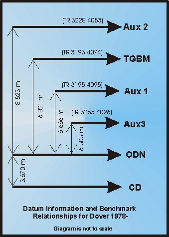
Benchmark Relationships
- TGZ = Chart Datum = 3.67m below ODN
- TGZ = Chart Datum = 10.491m below TGBM
- TGZ = Chart Datum = 10.336m below Aux 1
- TGZ = Chart Datum = 12.193m below Aux 2
- TGZ = Chart Datum = 9.973m below Aux 3
Glossary
- TGZ = Tide Gauge Zero
- TGBM = Tide Gauge Benchmark
- Aux = Auxiliary Benchmark
- ODN = Ordnance Datum Newlyn
- CD = Chart Datum
Related Fixed Station activities are detailed in Appendix 1
BODC Quality Control Flags
The following single character qualifying flags may be associated with one or more individual parameters with a data cycle:
| Flag | Description |
|---|---|
| Blank | Unqualified |
| < | Below detection limit |
| > | In excess of quoted value |
| A | Taxonomic flag for affinis (aff.) |
| B | Beginning of CTD Down/Up Cast |
| C | Taxonomic flag for confer (cf.) |
| D | Thermometric depth |
| E | End of CTD Down/Up Cast |
| G | Non-taxonomic biological characteristic uncertainty |
| H | Extrapolated value |
| I | Taxonomic flag for single species (sp.) |
| K | Improbable value - unknown quality control source |
| L | Improbable value - originator's quality control |
| M | Improbable value - BODC quality control |
| N | Null value |
| O | Improbable value - user quality control |
| P | Trace/calm |
| Q | Indeterminate |
| R | Replacement value |
| S | Estimated value |
| T | Interpolated value |
| U | Uncalibrated |
| W | Control value |
| X | Excessive difference |
SeaDataNet Quality Control Flags
The following single character qualifying flags may be associated with one or more individual parameters with a data cycle:
| Flag | Description |
|---|---|
| 0 | no quality control |
| 1 | good value |
| 2 | probably good value |
| 3 | probably bad value |
| 4 | bad value |
| 5 | changed value |
| 6 | value below detection |
| 7 | value in excess |
| 8 | interpolated value |
| 9 | missing value |
| A | value phenomenon uncertain |
| B | nominal value |
| Q | value below limit of quantification |
Appendix 1: Dover
Related series for this Fixed Station are presented in the table below. Further information can be found by following the appropriate links.
If you are interested in these series, please be aware we offer a multiple file download service. Should your credentials be insufficient for automatic download, the service also offers a referral to our Enquiries Officer who may be able to negotiate access.
| Series Identifier | Data Category | Start date/time | Start position | Cruise |
|---|---|---|---|---|
| 239967 | Sea surface elevation -unspecified | 1924-01-06 00:00:00 | 51.11694 N, 1.31806 E | Not applicable |
| 239979 | Sea surface elevation -unspecified | 1926-01-03 00:00:00 | 51.11694 N, 1.31806 E | Not applicable |
| 239980 | Sea surface elevation -unspecified | 1928-01-01 00:00:00 | 51.11694 N, 1.31806 E | Not applicable |
| 239992 | Sea surface elevation -unspecified | 1930-12-01 00:00:00 | 51.11694 N, 1.31806 E | Not applicable |
| 240004 | Sea surface elevation -unspecified | 1934-04-08 00:00:00 | 51.11694 N, 1.31806 E | Not applicable |
| 240016 | Sea surface elevation -unspecified | 1935-01-01 00:00:00 | 51.11694 N, 1.31806 E | Not applicable |
| 240028 | Sea surface elevation -unspecified | 1936-01-01 00:00:00 | 51.11694 N, 1.31806 E | Not applicable |
| 240041 | Sea surface elevation -unspecified | 1938-04-03 00:00:00 | 51.11694 N, 1.31806 E | Not applicable |
| 303406 | Sea surface elevation -unspecified | 1958-01-01 00:00:00 | 51.11694 N, 1.31806 E | Not applicable |
| 50580 | Sea surface elevation -unspecified | 1959-01-01 00:00:00 | 51.11694 N, 1.31806 E | Not applicable |
| 50635 | Sea surface elevation -unspecified | 1960-01-01 00:00:00 | 51.11694 N, 1.31806 E | Not applicable |
| 50647 | Sea surface elevation -unspecified | 1961-01-01 00:00:00 | 51.11694 N, 1.31806 E | Not applicable |
| 50660 | Sea surface elevation -unspecified | 1962-01-01 00:00:00 | 51.11694 N, 1.31806 E | Not applicable |
| 28887 | Sea surface elevation -unspecified | 1963-01-01 00:00:00 | 51.11694 N, 1.31806 E | Not applicable |
| 28899 | Sea surface elevation -unspecified | 1964-01-01 00:00:00 | 51.11694 N, 1.31806 E | Not applicable |
| 28906 | Sea surface elevation -unspecified | 1965-01-01 00:00:00 | 51.11694 N, 1.31806 E | Not applicable |
| 28918 | Sea surface elevation -unspecified | 1966-01-01 00:00:00 | 51.11694 N, 1.31806 E | Not applicable |
| 50684 | Sea surface elevation -unspecified | 1968-01-01 00:00:00 | 51.11694 N, 1.31806 E | Not applicable |
| 50696 | Sea surface elevation -unspecified | 1969-01-01 00:00:00 | 51.11694 N, 1.31806 E | Not applicable |
| 303418 | Sea surface elevation -unspecified | 1970-01-01 00:00:00 | 51.11694 N, 1.31806 E | Not applicable |
| 303431 | Sea surface elevation -unspecified | 1971-01-01 00:00:00 | 51.11694 N, 1.31806 E | Not applicable |
| 303443 | Sea surface elevation -unspecified | 1972-01-01 00:00:00 | 51.11694 N, 1.31806 E | Not applicable |
| 28931 | Sea surface elevation -unspecified | 1973-01-01 00:00:00 | 51.11694 N, 1.31806 E | Not applicable |
| 28943 | Sea surface elevation -unspecified | 1974-01-01 00:00:00 | 51.11694 N, 1.31806 E | Not applicable |
| 28955 | Sea surface elevation -unspecified | 1975-01-01 00:00:00 | 51.11694 N, 1.31806 E | Not applicable |
| 28967 | Sea surface elevation -unspecified | 1976-01-01 00:00:00 | 51.11694 N, 1.31806 E | Not applicable |
| 50611 | Sea surface elevation -unspecified | 1977-04-13 01:00:00 | 51.11439 N, 1.32267 E | Not applicable |
| 50703 | Sea surface elevation -unspecified | 1978-07-20 16:00:00 | 51.11439 N, 1.32267 E | Not applicable |
| 50592 | Sea surface elevation -unspecified | 1979-01-01 00:00:00 | 51.11439 N, 1.32267 E | Not applicable |
| 50623 | Sea surface elevation -unspecified | 1980-01-01 00:00:00 | 51.11439 N, 1.32267 E | Not applicable |
| 50230 | Sea surface elevation -unspecified | 1981-01-01 00:00:00 | 51.11439 N, 1.32267 E | Not applicable |
| 50659 | Sea surface elevation -unspecified | 1982-01-01 00:00:00 | 51.11439 N, 1.32267 E | Not applicable |
| 50242 | Sea surface elevation -unspecified | 1983-01-01 00:00:00 | 51.11439 N, 1.32267 E | Not applicable |
| 50254 | Sea surface elevation -unspecified | 1984-01-01 00:00:00 | 51.11439 N, 1.32267 E | Not applicable |
| 194800 | Sea surface elevation -unspecified | 1985-01-01 00:00:00 | 51.11439 N, 1.32267 E | Not applicable |
| 310372 | Sea surface elevation -unspecified | 1986-01-01 00:00:00 | 51.11439 N, 1.32267 E | Not applicable |
| 310384 | Sea surface elevation -unspecified | 1986-03-13 20:00:00 | 51.11439 N, 1.32267 E | Not applicable |
| 310396 | Sea surface elevation -unspecified | 1987-01-01 00:00:00 | 51.11439 N, 1.32267 E | Not applicable |
| 240053 | Sea surface elevation -unspecified | 1988-01-01 00:00:00 | 51.11439 N, 1.32267 E | Not applicable |
| 310403 | Sea surface elevation -unspecified | 1989-01-11 21:00:00 | 51.11439 N, 1.32267 E | Not applicable |
| 243770 | Sea surface elevation -unspecified | 1990-01-01 00:00:00 | 51.11439 N, 1.32267 E | Not applicable |
| 310360 | Sea surface elevation -unspecified | 1991-01-01 00:00:00 | 51.11439 N, 1.32267 E | Not applicable |
| 303455 | Sea surface elevation -unspecified | 1992-01-01 00:00:00 | 51.11439 N, 1.32267 E | Not applicable |
| 537859 | Sea surface elevation -unspecified | 1993-01-01 00:00:00 | 51.11439 N, 1.32267 E | Not applicable |
| 537860 | Sea surface elevation -unspecified | 1994-01-01 00:14:59 | 51.11439 N, 1.32267 E | Not applicable |
| 537872 | Sea surface elevation -unspecified | 1995-01-01 00:00:01 | 51.11439 N, 1.32267 E | Not applicable |
| 537884 | Sea surface elevation -unspecified | 1996-01-01 00:00:00 | 51.11439 N, 1.32267 E | Not applicable |
| 537896 | Sea surface elevation -unspecified | 1997-01-01 00:14:59 | 51.11439 N, 1.32267 E | Not applicable |
| 537903 | Sea surface elevation -unspecified | 1998-01-01 00:14:59 | 51.11439 N, 1.32267 E | Not applicable |
| 537915 | Sea surface elevation -unspecified | 1999-01-01 00:00:00 | 51.11439 N, 1.32267 E | Not applicable |
| 564789 | Sea surface elevation -unspecified | 2000-01-01 00:14:59 | 51.11439 N, 1.32267 E | Not applicable |
| 578195 | Sea surface elevation -unspecified | 2001-01-01 00:00:00 | 51.11439 N, 1.32267 E | Not applicable |
| 593315 | Sea surface elevation -unspecified | 2002-01-01 00:00:00 | 51.11439 N, 1.32267 E | Not applicable |
| 625896 | Sea surface elevation -unspecified | 2003-01-01 00:00:00 | 51.11439 N, 1.32267 E | Not applicable |
| 643995 | Sea surface elevation -unspecified | 2004-01-01 00:00:00 | 51.11439 N, 1.32267 E | Not applicable |
| 663032 | Sea surface elevation -unspecified | 2005-01-01 00:00:00 | 51.11439 N, 1.32267 E | Not applicable |
| 697446 | Sea surface elevation -unspecified | 2006-01-01 00:00:00 | 51.11439 N, 1.32267 E | Not applicable |
| 846332 | Sea surface elevation -unspecified | 2007-01-01 00:00:00 | 51.11439 N, 1.32267 E | Not applicable |
| 846817 | Sea surface elevation -unspecified | 2008-01-01 00:00:00 | 51.11439 N, 1.32267 E | Not applicable |
| 1110785 | Sea surface elevation -unspecified | 2009-01-01 00:00:00 | 51.11439 N, 1.32267 E | Not applicable |
| 1110797 | Sea surface elevation -unspecified | 2010-01-01 19:30:00 | 51.11439 N, 1.32267 E | Not applicable |
| 1110804 | Sea surface elevation -unspecified | 2011-01-01 00:00:00 | 51.11439 N, 1.32267 E | Not applicable |
