Metadata Report for BODC Series Reference Number 846264
Metadata Summary
Problem Reports
Data Access Policy
Narrative Documents
Project Information
Data Activity or Cruise Information
Fixed Station Information
BODC Quality Flags
SeaDataNet Quality Flags
Metadata Summary
Data Description |
|||||||||||||||||||||||||
|
|||||||||||||||||||||||||
Data Identifiers |
|||||||||||||||||||||||||
|
|||||||||||||||||||||||||
Time Co-ordinates(UT) |
|||||||||||||||||||||||||
|
|||||||||||||||||||||||||
Spatial Co-ordinates | |||||||||||||||||||||||||
|
|||||||||||||||||||||||||
Parameters |
|||||||||||||||||||||||||
|
|||||||||||||||||||||||||
|
|||||||||||||||||||||||||
Problem Reports
No Problem Report Found in the Database
Data Access Policy
Public domain data
These data have no specific confidentiality restrictions for users. However, users must acknowledge data sources as it is not ethical to publish data without proper attribution. Any publication or other output resulting from usage of the data should include an acknowledgment.
The recommended acknowledgment is
"This study uses data from the data source/organisation/programme, provided by the British Oceanographic Data Centre and funded by the funding body."
Narrative Documents
DATARING Datalogger Tide Gauge
The DATARING logger takes signals from Digiquartz pressure transducers and pressure operated gauges which are connected to the tidal pressure by a bubbler system. Float operated gauges can also supply a sea level signal to the datalogger. A number of sites also collect wind speed and direction data. The signals are processed to take account of water density, datum offset and calibration factors.
The data are averaged over a 15 minute period, with the centre points being o'clock, quarter past, half past, and quarter to. These readings are stored in internal memory and approximately 14 days can elapse before data are likely to be overwritten. The data can be accessed by POL and the Storm Tide Forecasting Service either locally or remotely over the telephone line. The data are retrieved on a weekly basis and appended onto the existing database, giving a continous record for each site.
Dataring direct pressure transducer
A submersible differential transducer contained in a watertight housing. The reference port is vented to the atmosphere via the power supply and signal cable, while the measuring port of the transducer is connected to a copper outlet nozzle, on the top of the transducer housing. The nozzle, measuring port and connecting tube are filled with oil, so the pressure is transmitted to the crystal element via the oil, thus keeping the instruments components free from the effects of saltwater.
Project Information
UK Tide Gauge Network
The national network of 'Class A' sea level gauges are deployed at 47 sites around the coast of the U.K.
The network was established after the serious flooding of the Thames estuary in 1953, which resulted from a violent storm in the North Sea.
The network sets out to obtain high quality tidal information through telemetry and provide warning of any possible flooding of coastal locations around the British Isles.
Data Activity or Cruise Information
No Data Activity or Cruise Information held for the Series
Fixed Station Information
Fixed Station Information
| Station Name | Avonmouth |
| Category | Coastal location |
| Latitude | 51° 30.65' N |
| Longitude | 2° 42.90' W |
| Water depth below MSL |
Avonmouth Site History
History Summary
| Station name | Avonmouth |
|---|---|
| Country | England U.K. |
| Latitude of measuring point | 51° 30' 27.9" N |
| Longitude of measuring point | 02° 42' 45.9" W |
| OS grid ref. of measuring point | ST 5047 7934 |
| Datum reference | All data refer to Admiralty Chart Datum (ACD) |
| Time reference | GMT (hours 00-23) |
| Contributor | Tide Gauge Inspectorate (TGI), Proudman Oceanographic Laboratory, Joseph Proudman Building, 6 Brownlow Street, Liverpool, L3 5DA, U.K. |
| Instrument type | Prior to 1984 - Port of Bristol Authority instrument. 1984 - DATARING system installed, Bubbler system. 1984 - Jetty hit by ship, equipment damaged. 1986 - DATARING - Bubbler system reinstalled. 1993 - DATARING - Underwater transducers installed. 24/02/2012 - SWANTEL S500 logger (includes static head correction) installed. |
| Site of measuring point | Mounted on superstructure of the wartime jetty. |
| Position of tide gauge building | ST 5063 7900 - G.R.P. Building |
| Observational period | 1961-1962,1972-1976,1979-1984,1986-2011 |
Benchmark descriptions
| Benchmark | OS Grid Ref. | Description | Height above ODN (m) |
|---|---|---|---|
| TGBM | ST 5057 7881 | OSBM bolt at base of bollard | 9.211 |
| Aux1 | ST 5072 7859 | Rivet adjacent to transit shed NW face W angle | 9.480 |
ODN = Ordnance Datum Newlyn
Datum Information
Tide Gauge Zero (TGZ) = Admiralty Chart Datum (ACD)
| Year | Data rel to ACD | Data rel to ODN | Data rel to TGZ | TGZ rel to ODN | TGZ rel to TGBM | ACD rel to ODN |
|---|---|---|---|---|---|---|
| 1972 | 0.000 | -6.500 | 0.000 | 0.000 | not available | 0.000 |
| 1973 | 0.000 | -6.500 | 0.000 | 0.000 | not available | 0.000 |
| 1974 | 0.000 | -6.500 | 0.000 | 0.000 | not available | 0.000 |
| 1975 | 0.000 | -6.500 | 0.000 | 0.000 | not available | 0.000 |
| 1976 | 0.000 | -6.500 | 0.000 | -6.500 | not available | -6.500 |
| 1979 | 0.000 | -6.500 | 0.000 | -6.500 | not available | -6.500 |
| 1980 | 0.000 | -6.500 | 0.000 | -6.500 | not available | -6.500 |
| 1981 | 0.000 | -6.500 | 0.000 | -6.500 | not available | -6.500 |
| 1982 | 0.000 | -6.500 | 0.000 | -6.500 | not available | -6.500 |
| 1983 | 0.000 | -6.500 | 0.000 | -6.500 | not available | -6.500 |
| 1984 | -1.186 | -7.686 | 0.000 | -7.686 | not available | -6.500 |
| 1986 | 0.000 | -6.500 | 0.000 | -6.500 | -15.711 | -6.500 |
| 1987 | 0.000 | -6.500 | 0.000 | -6.500 | -15.711 | -6.500 |
| 1988 | 0.000 | -6.500 | 0.000 | -6.500 | -15.711 | -6.500 |
| 1989 | 0.000 | -6.500 | 0.000 | -6.500 | 15.711 | -6.500 |
| 1990 | 0.000 | -6.500 | 0.000 | -6.500 | -15.711 | -6.500 |
Corrected Timing Errors
The table below lists the notified time errors for which corrections have been made (if the time error is positive the clock was fast, and if negative the clock was slow):
| Start Time/Date of Error | Error at Start of Period (mins) | End Time/Date of Error | Error at End of Period (mins) |
|---|---|---|---|
| 1600h 10 Aug 1973 | -2.0 | 0700h 16 Aug 1973 | -4.0 |
1973: 21 missing errors
| Start Time/Date of Error | Error at Start of Period (mins) | End Time/Date of Error | Error at End of Period (mins) |
|---|---|---|---|
| 1100h 23 Aug 1974 | 2.0 | 1300h 27 Aug 1974 | -1.0 |
1974: 39 missing errors
1975: 24 missing errors
1979: 1 missing error
1980: 1 missing error
1982: 3 missing errors
Corrected Datum Errors
1973: 1 missing error
1974: 1 missing error
1975: 5 missing errors
Benchmark Relationships
TGZ = 6.50 m below Ordnance Datum Newlyn (ODN)
TGZ = 15.711 m below TGBM
Note: Please also see document 83034
Quality Assessment
All data have been compared with the current Harmonic Constants library, and residuals checked. Records have been visually inspected for spikes, datum shifts and timing errors.
In March 1993, the bubbler gauges (ASLVBG0*) were replaced by pressure transducers (ASLVTD0*).
From the beginning of January 2004, channel two (ASLVTD02) became the primary channel and channel one (ASLVTD01) became the backup channel.
The completeness index is given for the primary channel only.
| Period | Parameter | Missing Data | Suspect Data | Completeness index (%) | Sample interval |
|---|---|---|---|---|---|
| 1961 | ASLVZZ01 | 001-174 | 220,290-296 | 52 | 60 minutes |
| 1962 | ASLVZZ01 | 222-365 | 086 | 61 | 60 minutes |
| 1972 | ASLVZZ01 | 001-357 | None | 2 | 60 minutes |
| 1973 | ASLVZZ01 | 130-135 | 057-058 | 98 | 60 minutes |
| 1974 | ASLVZZ01 | 026-028,035-036,234-235 | 016 | 98 | 60 minutes |
| 1975 | ASLVZZ01 | 124-125,178 | 025,064 | 99 | 60 minutes |
| 1976 | ASLVZZ01 | 002-366 | None | 1 | 60 minutes |
| 1979 | ASLVZZ01 | 001-330 | None | 10 | 60 minutes |
| 1980 | ASLVZZ01 | 018-137, 171-366 | None | 14 | 60 minutes |
| 1981 | ASLVZZ01 | 001-327, 347-348 | 340-343 | 10 | 60 minutes |
| 1982 | ASLVZZ01 | 095-365 | 045-046, 091 | 26 | 60 minutes |
| 1983 | ASLVZZ01 | 001-364 | None | 1 | 60 minutes |
| 1984 | ASLVZZ01 | 082-328 | None | 23 (January to November) | 60 minutes |
| ASLVBG01 | 347-366 | None | 5 (November to December) | 60 minutes | |
| 1986 | ASLVBG01 | 001-267 | None | 27 | 60 minutes |
| 1987 | ASLVBG01 | 014-016, 117-121, 189-195, 335-350 | 007-010, 037-039, 086, 289-290 | 93 | 60 minutes |
| 1988 | ASLVBG01 | 064-070, 103-105, 329-366 | None | 88 | 60 minutes |
| 1989 | ASLVBG01 | 001-040 | None | 89 | 60 minutes |
| 1990 | ASLVBG01 | 093-095 | None | 99 | 60 minutes |
| 1991 | ASLVBG01 | 037-041, 344-347, 351-358 | 067-069, 316 | 96 | 60 minutes |
| 1992 | ASLVBG01 | 021-024, 028-029, 299-318, 357-366 | None | 92 | 60 minutes |
| 1993 | ASLVBG01,ASLVBG02 | 068-070 | None | 18 (January to March) | 15 minutes |
| ASLVTD01 | 075,089-092 | 070-075,092-098 | 80 (March to December) | 15 minutes | |
| ASLVTD02 | 075-103 | 070-075 | |||
| 1994 | ASLVTD01 | 227-280 | 177-227 | 85 | 15 minutes |
| ASLVTD02 | 222,227-280 | 186-222,222-227 | |||
| 1995 | ASLVTD01 | 354-365 | 047-048 | 97 | 15 minutes |
| ASLVTD02 | 354-365 | None | |||
| 1996 | ASLVTD01 | 164-171,198-203,204- 205,213-214,217-232 248-253 | 188 | 89 | 15 minutes |
| ASLVTD02 | 164-171,198-203,204-205,213-214,217-232 248-253 | None | |||
| 1997 | ASLVTD01,ASLVTD02 | 189,200-203,218-222,231-232 | None | 98 | 15 minutes |
| 1998 | ASLVTD01,ASLVTD02 | 135,153-154,168-174,218-221,231 | None | 97 | 15 minutes |
| 1999 | ASLVTD01 | None | 008,015,018-365 | 99 | 15 minutes |
| ASLVTD02 | 040-041,047-048 | 068,069,070-365 | |||
| 2000 | ASLVTD01 | 046-052,060,144-147,168-170,185-189,254-255 | 001-046,244,271,272,273,302,347 | 96 | 15 minutes |
| ASLVTD02 | 046-052,060,144-147,168-170,185-189,254-255 | 001-046,151,152,153,154,155,156,157,158,159, 160,163,164,165,167,168,170-173,175,177,178-186,189,190,193,195,196,197,198,199,200-225, 227-234,237-243,246,248,253,254,257,266,267 | |||
| 2001 | ASLVTD01 | 023-025,031-036,184-193,310-326,193-310,326-365 | 058-117,121-126,139-184, | 92 | 15 minutes |
| ASLVTD02 | 023-025,031-036,184-193,310-326 | 058-117,165,176,228 | |||
| 2002 | ASLVTD01 | 152-181 | 001-151,182-276 | 92 | 15 minutes |
| ASLVTD02 | None | None | |||
| 2003 | ASLVTD01,ASLVTD02 | 175,261 | None | 99 | 15 minutes |
| 2004 | ASLVTD01 | 335-366 | 070-334 | ||
| ASLVTD02 | 335-366 | None | 92 | 15 minutes | |
| 2005 | ASLVTD01 | 001-027 | 027-365 | ||
| ASLVTD02 | 001-027 | None | 93 | 15 minutes | |
| 2006 | ASLVTD01 | 054-068 | 001-054,068-365 | ||
| ASLVTD02 | 054-068 | None | 96 | 15 minutes | |
| 2007 | ASLVTD01 | None | 001-365 | ||
| ASLVTD02 | None | None | 100 | 15 minutes | |
| 2008 | ASLVTD02 | None | 001-366 | ||
| ASLVTD02 | None | None | 100 | 15 minutes | |
| 2009 | ASLVTD01 | 133,224 | 001-365 | ||
| ASLVTD02 | 133,224 | None | 99 | 15 minutes | |
| 2010 | ASLVTD01 | None | 001-365 | ||
| ASLVTD02 | None | 097-098,106-109,133,138-141,264 | 100 | 15 minutes | |
| 2011 | ASLVTD01 | None | 001-365 | ||
| ASLVTD02 | None | None | 100 | 15 minutes |
Avonmouth Datum Information 1986-
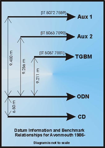
Benchmark Relationships
- TGZ = Chart Datum = 6.50m below ODN
- TGZ = Chart Datum = 15.711m below TGBM
- TGZ = Chart Datum = 15.98m below Aux 1
- TGZ = Chart Datum = 15.956m below Aux 2
Glossary
- TGZ = Tide Gauge Zero
- TGBM = Tide Gauge Benchmark
- AUX = Auxiliary Benchmark
- ODN = Ordnance Datum Newlyn
- CD = Chart Datum
Related Fixed Station activities are detailed in Appendix 1
BODC Quality Control Flags
The following single character qualifying flags may be associated with one or more individual parameters with a data cycle:
| Flag | Description |
|---|---|
| Blank | Unqualified |
| < | Below detection limit |
| > | In excess of quoted value |
| A | Taxonomic flag for affinis (aff.) |
| B | Beginning of CTD Down/Up Cast |
| C | Taxonomic flag for confer (cf.) |
| D | Thermometric depth |
| E | End of CTD Down/Up Cast |
| G | Non-taxonomic biological characteristic uncertainty |
| H | Extrapolated value |
| I | Taxonomic flag for single species (sp.) |
| K | Improbable value - unknown quality control source |
| L | Improbable value - originator's quality control |
| M | Improbable value - BODC quality control |
| N | Null value |
| O | Improbable value - user quality control |
| P | Trace/calm |
| Q | Indeterminate |
| R | Replacement value |
| S | Estimated value |
| T | Interpolated value |
| U | Uncalibrated |
| W | Control value |
| X | Excessive difference |
SeaDataNet Quality Control Flags
The following single character qualifying flags may be associated with one or more individual parameters with a data cycle:
| Flag | Description |
|---|---|
| 0 | no quality control |
| 1 | good value |
| 2 | probably good value |
| 3 | probably bad value |
| 4 | bad value |
| 5 | changed value |
| 6 | value below detection |
| 7 | value in excess |
| 8 | interpolated value |
| 9 | missing value |
| A | value phenomenon uncertain |
| B | nominal value |
| Q | value below limit of quantification |
Appendix 1: Avonmouth
Related series for this Fixed Station are presented in the table below. Further information can be found by following the appropriate links.
If you are interested in these series, please be aware we offer a multiple file download service. Should your credentials be insufficient for automatic download, the service also offers a referral to our Enquiries Officer who may be able to negotiate access.
| Series Identifier | Data Category | Start date/time | Start position | Cruise |
|---|---|---|---|---|
| 303295 | Sea surface elevation -unspecified | 1961-06-24 00:00:00 | 51.51089 N, 2.71497 W | Not applicable |
| 303302 | Sea surface elevation -unspecified | 1962-01-01 00:00:00 | 51.51089 N, 2.71497 W | Not applicable |
| 194467 | Sea surface elevation -unspecified | 1972-12-22 11:00:00 | 51.51089 N, 2.71497 W | Not applicable |
| 194479 | Sea surface elevation -unspecified | 1973-01-01 00:00:00 | 51.51089 N, 2.71497 W | Not applicable |
| 194480 | Sea surface elevation -unspecified | 1974-01-01 00:00:00 | 51.51089 N, 2.71497 W | Not applicable |
| 194492 | Sea surface elevation -unspecified | 1975-01-01 00:00:00 | 51.51089 N, 2.71497 W | Not applicable |
| 194511 | Sea surface elevation -unspecified | 1976-01-01 00:00:00 | 51.51089 N, 2.71497 W | Not applicable |
| 194523 | Sea surface elevation -unspecified | 1979-11-26 13:00:00 | 51.51089 N, 2.71497 W | Not applicable |
| 194547 | Sea surface elevation -unspecified | 1980-01-01 00:00:00 | 51.51089 N, 2.71497 W | Not applicable |
| 194559 | Sea surface elevation -unspecified | 1981-11-23 16:00:00 | 51.51089 N, 2.71497 W | Not applicable |
| 194560 | Sea surface elevation -unspecified | 1982-01-01 00:00:00 | 51.51089 N, 2.71497 W | Not applicable |
| 194572 | Sea surface elevation -unspecified | 1983-12-30 16:00:00 | 51.51089 N, 2.71497 W | Not applicable |
| 194584 | Sea surface elevation -unspecified | 1984-01-01 00:00:00 | 51.51089 N, 2.71497 W | Not applicable |
| 194596 | Sea surface elevation -unspecified | 1984-11-23 15:00:00 | 51.51089 N, 2.71497 W | Not applicable |
| 194443 | Sea surface elevation -unspecified | 1986-09-24 19:00:00 | 51.51089 N, 2.71497 W | Not applicable |
| 194455 | Sea surface elevation -unspecified | 1987-01-01 00:00:00 | 51.51089 N, 2.71497 W | Not applicable |
| 239943 | Sea surface elevation -unspecified | 1988-01-01 00:00:00 | 51.51089 N, 2.71497 W | Not applicable |
| 242717 | Sea surface elevation -unspecified | 1989-02-09 00:00:00 | 51.51089 N, 2.71497 W | Not applicable |
| 243769 | Sea surface elevation -unspecified | 1990-01-01 00:00:00 | 51.51089 N, 2.71497 W | Not applicable |
| 310279 | Sea surface elevation -unspecified | 1991-01-01 00:00:00 | 51.51089 N, 2.71497 W | Not applicable |
| 303283 | Sea surface elevation -unspecified | 1992-01-01 00:00:00 | 51.51089 N, 2.71497 W | Not applicable |
| 537429 | Sea surface elevation -unspecified | 1993-01-01 00:14:59 | 51.51089 N, 2.71497 W | Not applicable |
| 537430 | Sea surface elevation -unspecified | 1994-01-01 00:00:00 | 51.51089 N, 2.71497 W | Not applicable |
| 537442 | Sea surface elevation -unspecified | 1995-01-01 00:14:59 | 51.51089 N, 2.71497 W | Not applicable |
| 537454 | Sea surface elevation -unspecified | 1996-01-04 12:00:00 | 51.51089 N, 2.71497 W | Not applicable |
| 537466 | Sea surface elevation -unspecified | 1997-01-01 00:00:00 | 51.51089 N, 2.71497 W | Not applicable |
| 537478 | Sea surface elevation -unspecified | 1998-01-01 00:14:59 | 51.51089 N, 2.71497 W | Not applicable |
| 537491 | Sea surface elevation -unspecified | 1999-01-01 00:00:00 | 51.51089 N, 2.71497 W | Not applicable |
| 564716 | Sea surface elevation -unspecified | 2000-01-01 00:00:00 | 51.51089 N, 2.71497 W | Not applicable |
| 578122 | Sea surface elevation -unspecified | 2001-01-01 00:14:59 | 51.51089 N, 2.71497 W | Not applicable |
| 593259 | Sea surface elevation -unspecified | 2002-01-01 00:00:00 | 51.51089 N, 2.71497 W | Not applicable |
| 625835 | Sea surface elevation -unspecified | 2003-01-01 00:00:00 | 51.51089 N, 2.71497 W | Not applicable |
| 643934 | Sea surface elevation -unspecified | 2004-01-01 00:00:00 | 51.51089 N, 2.71497 W | Not applicable |
| 662968 | Sea surface elevation -unspecified | 2005-01-27 12:30:00 | 51.51089 N, 2.71497 W | Not applicable |
| 697378 | Sea surface elevation -unspecified | 2006-01-01 00:00:00 | 51.51089 N, 2.71497 W | Not applicable |
| 846750 | Sea surface elevation -unspecified | 2008-01-01 00:00:00 | 51.51089 N, 2.71497 W | Not applicable |
| 1110576 | Sea surface elevation -unspecified | 2009-01-01 00:00:00 | 51.51089 N, 2.71497 W | Not applicable |
| 1110588 | Sea surface elevation -unspecified | 2010-01-01 00:00:00 | 51.51089 N, 2.71497 W | Not applicable |
| 1110607 | Sea surface elevation -unspecified | 2011-01-01 00:00:00 | 51.51089 N, 2.71497 W | Not applicable |
