Metadata Report for BODC Series Reference Number 981251
Metadata Summary
Problem Reports
Data Access Policy
Narrative Documents
Project Information
Data Activity or Cruise Information
Fixed Station Information
BODC Quality Flags
SeaDataNet Quality Flags
Metadata Summary
Data Description |
|||||||||||||||||||||||||||||||||||||
|
|||||||||||||||||||||||||||||||||||||
Data Identifiers |
|||||||||||||||||||||||||||||||||||||
|
|||||||||||||||||||||||||||||||||||||
Time Co-ordinates(UT) |
|||||||||||||||||||||||||||||||||||||
|
|||||||||||||||||||||||||||||||||||||
Spatial Co-ordinates | |||||||||||||||||||||||||||||||||||||
|
|||||||||||||||||||||||||||||||||||||
Parameters |
|||||||||||||||||||||||||||||||||||||
|
|||||||||||||||||||||||||||||||||||||
|
|||||||||||||||||||||||||||||||||||||
Problem Reports
No Problem Report Found in the Database
Data Quality Report
No quality control has been performed on these scanned images.
Due to the age of the registers and charts, there was very little metadata available and several assumptions had to be made regarding the parameters applied. It was assumed that all times are in UTC, though there is nothing to indicate this. Very generic parameters were selected. All images have been assigned the very general sea level parameter of ASLVZZ01 (Surface elevation (unspecified datum) of the water body).
Where two measurements exist per day (e.g. measurements made at high water only), a sample interval of 45000 seconds (12.5 hours) has been assigned, though the actual time between successive high waters might be less than or greater than 12.5 hours (through modifications to the tidal signal, such as bathymetry or metrological forcing). Where there are four measurements a day (taken at both high and low water), a sample interval of 22500 seconds (6.25 hours) has been applied. For the continuous measurements, the sample interval could not be left null, so a value of 1 second was assigned.
Standard BODC parameters have been used, even though the scientific units mentioned in the parameters are metric, and most of the measurements in the scanned images are made in imperial units. Because it is possible to convert between imperial and metric units, no new parameter codes were created.
Where wind speed was given in units that appeared to be the Beaufort scale, then it was assumed that they had come from manual observations, and the parameter WMOCWFBF (Wind speed in the atmosphere by visual estimation and conversion to Beaufort scale) was selected.
Where wind speed was given in units that went above 12 (which would be a hurricane on the Beaufort scale, and unlikely to occur often) it was assumed that they were measurements taken by an instrument, and the parameter EWSBSS01 (Wind speed in the atmosphere by in-situ anemometer) was used.
For some of the registers, a Maximum hourly wind speed was listed. Upon consultation with archivists at the Met Office, who reported that Maximum hourly speed was '...the maximum mean wind speed recorded...during the 24 hours ending at 0900 GMT.', the parameter code ESSAMX01 (Wind speed hourly maximum in the atmosphere by in-situ anemometer) was applied. These registers also include a maximum gust speed which is '...the highest gust recorded during the 24 hours to 0900 GMT and the time is the time of the highest gust.' These have been assigned the parameter EGTSSS01 (Wind speed (gust) in the atmosphere by in-situ anemometer).
Where wind speed was measured on the Beaufort scale, it is assumed that the wind direction measurements were also visual measurements, and so the parameter WMOCDWXX (Wind from direction in the atmosphere by visual estimation and conversion to WMO code using table 0885/0877) was applied. Where wind speed has been assigned the parameter EWSBSS01, it was assumed that the wind direction was also measured by an instrument, and so the parameter EWDASS01 (Wind from direction in the atmosphere by in-situ anemometer) has been assigned.
Where visibility observations exist, using Beaufort letters, it was assumed that the readings were made manually, and so the parameter WMOCPWXX (Present weather in the atmosphere by visual estimation and conversion to WMO code using table 4677/4501) was applied, as conversions can be made between Beaufort weather notation and the WMO Codes.
Barometer measurements have been assigned the parameter code CAPHZZ01 (Pressure (measured variable) exerted by the atmosphere) which is using an unspecified method to make the measurements.
Some registers also include measurements of rainfall, for the previous 24 hours to 0900 GMT. These have been assigned the parameter CPRPRG01 (Thickness of precipitation amount (liquid water equivalent) in the atmosphere by in-situ rain gauge).
Some registers appear to contain measurements of air temperature, in degrees Fahrenheit. This is just an assumption, based on the range of these measurements and the changes that can be seen over the year. These measurements have been assigned the parameter CDTAZZ01 (Temperature of the atmosphere by thermometer).
Data Access Policy
Public domain data
These data have no specific confidentiality restrictions for users. However, users must acknowledge data sources as it is not ethical to publish data without proper attribution. Any publication or other output resulting from usage of the data should include an acknowledgment.
The recommended acknowledgment is
"This study uses data from the data source/organisation/programme, provided by the British Oceanographic Data Centre and funded by the funding body."
Narrative Documents
Data Processing Notes
Long term sea level records have a wide range of scientific and practical applications. They are important to climate change studies (to give an indication of sea level rise), operational oceanography (looking at storm surges and tides) and civil engineering (flood defences) amongst others.
The British Oceanographic Data Centre (BODC) was in possession of, or aware of, several large historic analogue sea level datasets which could be made available to the general community, but were in need of digitising and/or quality controlling before they could be added to the National Oceanographic Database.
BODC bid for funding from MEDIN, matched by BODC funds, and worked commenced on the rescue of the historical UK sea level data in September 2009.
BODC selected several long historic analogue records, which could extend back existing long records, and sent them to an external company, Digitise-it.com Ltd, for scanning. The company used a bookeye scanner to preserve the delicate records, and supplied 300x300dpi jpeg images, in colour or greyscale as appropriate.
Project Information
No Project Information held for the Series
Data Activity or Cruise Information
No Data Activity or Cruise Information held for the Series
Fixed Station Information
Fixed Station Information
| Station Name | Sheerness |
| Category | Coastal location |
| Latitude | 51° 26.74' N |
| Longitude | 0° 44.61' E |
| Water depth below MSL |
Sheerness (Kent) Site History
History Summary
| Station name | Sheerness |
|---|---|
| Country | England U.K. |
| Latitude of measuring point | 1973 onwards: 51° 26' 44.3" N 1963-1973: 51° 26' 44" N 1962: 51° 27' N 1955-1961: 51° 26' 35" N |
| Longitude of measuring point | 1973 onwards: 00° 44' 36.1" E 1963-1973: 00° 44' 42.5" E 1962: 00° 45' E 1955-1961: 00° 45' 00" E |
| OS grid ref. of measuring point | TQ 9074 7542 |
| Datum reference | All data refer to Admiralty Chart Datum (ACD) |
| Time reference | GMT (hours 00-23) |
| Contributor | Tide Gauge Inspectorate (TGI), Proudman Oceanographic Laboratory, Joseph Proudman Building, 6 Brownlow Street, Liverpool, L3 5DA, U.K. |
| Instrument type | 1955 - Lege gauge installed on Cornwallis Jetty. 1962 - Munro gauge installed at Garrison Point. 1963 - Munro gauge resited 22.5m south of previous location. 17/04/1973 - Munro gauge disconnected for maintainance. 17 - 19/04/1973 - Temporary Munro gauge used in Ro/Ro hut. 19/04/1973 - Munro gauge reconnected at Garrison Point. 21/05/1973 - New Munro gauge installed on Ro/Ro Jetty. 1980 - Ott pneumatic gauge replaced Munro gauge. 1983 - Aanderra gauge installed, to replace Ott gauge. 1986 - Dataring Bubbler system installed. 27/01/2012 - SWANTEL S500 logger (includes static head correction) installed. |
| Site of measuring point | Below tide gauge building |
| Position of tide gauge building | TQ 9074 7542 - Brick tide gauge building on jetty, west side of Garrison Point |
| Observational periods | Scans of tide gauge registers: 1870-1894,1929-1941 Digital data: 1952,1958,1965-1975,1980-2011 |
Instrument History
| 1932-1953 | Tide gauge operating on Cornwallis Pier, Sheerness. Gauge destroyed in January 1953. |
|---|---|
| 1955-1964 | New Lege gauge installed in June; records began in August. Same site in Sheerness dockyard as previous gauge. The recorder was sited in the Security Police Office 610m away from the stilling well and connected electrically to the float. The well was enclosed by a wire mesh cage which was kept locked. Frequent breakdowns occurred in electrical transmission. The drum above the well was not used. |
| 1962-1973 | Munro gauge installed on 2 November at Garrison Point, Ordnance Survey (OS) Grid Reference TQ 9074 7547. The Authority responsible for operating the gauge was the Medway Conservancy Board; later the Medway Ports Authority. There was no tide gauge hut; the gauge was usually covered by a waterproof hood. In April 1963 the gauge was resited 22.56m south of its previous position. In April 1967 weatherproof doors were fitted, and in April 1969 a hut was built to house the gauge. |
| May 1973+ | The Gauge was resited in May 1973 due to work on the harbour wall. The new well is 0.30m in diameter and has two inlet holes at the base. A Lea gauge belonging to the Southern Water Authority was installed in 1973 which was still operating satisfactorily in 1982. |
| 1980-1983 | An OTT pneumatic gauge was installed and connected to an OTT paper tape recorder. The recorder was sited in a building owned by the Southern Water Authority, adjacent to the Medway Ports Authority tide gauge hut on the Flushing Ferry Pier. |
| 1983+ | In July 1983 an Aanderaa WLR625 was installed as a replacement for the OTT gauge. |
| Oct 1986+ | Hourly heights filtered from 15 min digiquartz values.Elevation of gauge above datum 9.0m. |
Benchmarks
| Benchmark | OS Grid Reference | Description | Height above ODN (m) |
|---|---|---|---|
| DISUSED TGBM (1960 - 1962) | BM Rivet | 4.00 | |
| TGBM (September 1973 onwards) | TQ 9080 7549 | Flush bracket 11859, Garrison Fort, south angle, south west building. | 4.62 |
| 4.632 (Re-levelled 1976) | |||
| DISUSED Aux1 (1960 - 1962. Thereafter TGBM until destroyed in 1972.) | TQ 9082 7543 | Flushing bracket S.0527, south face, south west angle of building. | 5.03 |
| Aux1 | TQ 9133 7523 | Flush bracket G.4790, on house, north west angle, north face. | 4.486 |
| DISUSED Aux2 (1960 - April 1967. Thereafter Aux 1.) | TQ 9133 7523 | Flush bracket G.4790, on house, north west angle, north face. | 4.46 |
| 4.48 (Re-levelled 1976) | |||
| DISUSED Aux2 (April 1967 - April 1976) | TQ 9070 7550 | Bolt on gun emplacement | 17.78 |
| Aux2 (September 1983 onwards) | TQ 9115 7533 | Wall on south west side of road, north east angle. | 3.339 |
| DISUSED Aux3 (March 1974 - April 1976. Thereafter Aux 2 until Sept 1983) | TQ 9082 7553 | Bolt, north east side of entrance to fort. | 7.18 |
| 7.19 (Re-levelled 1976) | |||
| DISUSED Aux3 (September 1978 to Sepember 1983) | TQ 9084 7553 | Garrison Point Fort, south west face, 0.6m south angle. | 4.51 |
| Aux3 (September 1983 onwards) | TQ 9147 7516 | PA Bolt disused church, south west side of road, east face, north east angle. | 4.413 |
| NBM | TQ 9073 7542 | Rivet curb W side of jetty opp. T.G. Building | 5.275 |
| NRABM | TQ 9074 7542 | Bolt SE corner of jetty | 5.280 |
ODN = Ordnance Datum Newlyn
Levelling
The benchmarks were incorporated into the Ordnance Survey levelling network in 1960. Benchmarks were reconfirmed in 1961, twice in 1963,1964, annually from 1977 onwards, and every 6 months between 1965 and 1976. No levelling was carried out in 1962.
The table below shows TGZ relative to ODN and the TGBM, calculated from an average of mean well soundings.
Heights have been adjusted by the data relative to ACD values, so that all data are now referred to Admiralty Chart Datum.
Datum information
Also see document 83375
| Year | Data rel to ACD | Data rel to ODN | Data rel to TGZ | TGZ rel to ODN | TGZ rel to TGBM | ACD rel to ODN |
|---|---|---|---|---|---|---|
| 1952 | 0.308 | -2.588 | 0.000 | -2.588 | 0.000 | -2.896 |
| 1958 | 0.308 | -2.588 | 0.000 | -2.588 | 0.000 | -2.896 |
| 1965 | -0.042 | -2.561 | 0.000 | -2.561 | -7.587 | -2.603 |
| 1966 | -0.069 | -2.518 | 0.000 | -2.518 | -7.545 | -2.588 |
| 1967 | 0.030 | -2.618 | 0.000 | -2.618 | -7.644 | -2.588 |
| 1968 | 0.003 | -2.893 | 0.000 | -2.893 | -7.919 | -2.896 |
| 1969 | -3.048 | -5.944 | -3.048 | -2.896 | -7.922 | -2.896 |
| 1970 | -3.036 | -5.931 | -3.048 | -2.883 | -7.910 | -2.896 |
| 1971 | 0.058 | -2.838 | 0.000 | -2.838 | -7.864 | -2.896 |
| 1972 | 0.073 | -2.827 | 0.000 | -2.827 | -7.853 | -2.900 |
| 1973 | 0.053 | -2.847 | 0.000 | -2.847 | -7.467 | -2.900 |
| 1974 | 0.053 | -2.847 | 0.000 | -2.847 | -7.467 | -2.900 |
| 1975 | 0.063 | -2.837 | 0.000 | -2.837 | -7.457 | -2.900 |
| 1980 | 0.000 | -2.900 | 0.000 | -2.900 | -7.530 | -2.900 |
| 1981 | 0.000 | -2.900 | 0.000 | -2.900 | -7.530 | -2.900 |
| 1982 | 0.000 | -2.900 | 0.000 | -2.900 | -7.530 | -2.900 |
| 1983 Jan-May | 0.000 | -2.900 | 0.000 | -2.900 | -7.530 | -2.900 |
| 1983 Jul-Dec | -2.520 | -5.420 | 0.000 | -5.420 | -10.050 | -2.900 |
| 1984 | -2.520 | -5.420 | 0.000 | -5.420 | -10.050 | -2.900 |
| 1985 | -2.520 | -5.420 | 0.000 | -5.420 | -10.050 | -2.900 |
| 1986 Jan-Oct | -2.520 | -5.420 | 0.000 | -5.420 | -10.050 | -2.900 |
| 1986 Oct-Dec | 0.000 | -2.900 | 0.000 | -2.900 | -7.532 | -2.900 |
| 1987 | 0.000 | -2.900 | 0.000 | -2.900 | -7.530 | -2.900 |
| 1988 | 0.000 | -2.900 | 0.000 | -2.900 | -7.532 | -2.900 |
| 1989 | 0.000 | -2.900 | 0.000 | -2.900 | -7.532 | -2.900 |
| 1990 | 0.000 | -2.900 | 0.000 | -2.900 | -7.532 | -2.900 |
| 1991 | 0.000 | -2.900 | 0.000 | -2.900 | -7.532 | -2.900 |
| 1992 | 0.000 | -2.900 | 0.000 | -2.900 | -7.532 | -2.900 |
Notes
- A tide staff was sited on Cornwallis jetty 610m from the recorder between 1960 and 1962. Tide staff zero (TSZ) was defined as Ordnance Datum Newlyn (ODN) minus 2.55m.
- The tide staff was resited directly below the Munro recorder in February 1963, with TSZ = ODN - 2.60m.
- In April 1963 the gauge was resited and a new tide staff was sited 22.5m from the recorder; TSZ = ODN - 2.57m.
- In June 1965 a new tide staff was installed 50.3m from the tide gauge, TSZ = ODN - 2.54m.
- On 9 September the lower part of the tide staff was carried away in a gale. A new tide staff was installed in December 1966, 22.9m from the recorder; TSZ = ODN - 2.59m.
- On 1 April 1968 the tide staff was reset to Admiralty Chart Datum (ACD) i.e. TSZ = ODN - 2.90m. In April 1972 the tide staff was removed to a temporary position 80m from the recorder; TSZ = ODN - 2.91m.
- On 27 September 1973 a new tide staff was installed 20m from the new Munro recorder; TSZ = ODN - 2.88m. The tide staff was resited 2m from the recorder after March 1974 TSZ = ODN - 2.88m.
- On 14 September 1977 the tide staff was disturbed; TSZ = ODN - 2.89m. On 7 September a new tide staff was installed in the same position as the previous one; TSZ = ODN - 2.90m.
- ACD (Sheerness) was quoted as ODN - 2.55m in 1931 and ODN - 2.60m between 1951 and 1964. At this time ACD was defined locally as 2.74m above the sill of the Great Basin. In 1964 there was a new connection and ACD became ODN - 2.59m; it was readjusted to ODN - 2.90m in 1968.
Corrected Timing Errors
The table below lists the notified time errors for which corrections have been made (if the time error is positive the clock was fast, and if negative the clock was slow).
| Start Time/Date of Error | Error at Start of Period (mins) | End Time/Date of Error | Error at End of Period (mins) |
|---|---|---|---|
| 0900h 01 Mar 1965 | 0.0 | 0900h 08 Mar 1965 | 10.0 |
| 0900h 28 Jun 1965 | -3.0 | 1200h 28 Jun 1965 | -3.0 |
| 1300h 28 Jun 1965 | 4.0 | 0900h 01 Jul 1965 | 4.0 |
| 0800h 23 Aug 1965 | -5.0 | 1300h 23 Aug 1965 | -5.0 |
| 0800h 04 Oct 1965 | -5.0 | 1100h 05 Oct 1965 | -5.0 |
| 1200h 05 Oct 1965 | 0.0 | 0800h 11 Oct 1965 | 5.0 |
| 1400h 16 Oct 1965 | 3.0 | 0700h 18 Oct 1965 | 10.0 |
| 0800h 18 Oct 1965 | 0.0 | 0800h 25 Oct 1965 | 4.0 |
| 0900h 20 Dec 1965 | 0.0 | 2000h 23 Dec 1965 | 8.0 |
| 0900h 03 Jan 1966 | 0.0 | 0900h 10 Jan 1966 | 5.0 |
| 1000h 17 Jun 1966 | 0.0 | 2000h 20 Jan 1966 | 4.0 |
| 0900h 14 Feb 1966 | 0.0 | 0900h 21 Feb 1966 | 10.0 |
| 0900h 28 Feb 1966 | 0.0 | 0800h 07 Mar 1966 | 10.0 |
| 0900h 14 Mar 1966 | 0.0 | 0700h 19 Mar 1966 | 5.0 |
| 0900h 21 Mar 1966 | 0.0 | 0800h 28 Mar 1966 | 5.0 |
| 0800h 04 Apr 1966 | 0.0 | 0700h 11 Apr 1966 | 8.0 |
| 0800h 11 Apr 1966 | 0.0 | 0800h 18 Apr 1966 | 7.0 |
| 0900h 20 Jun 1966 | 0.0 | 0800h 27 Jun 1966 | 7.0 |
| 0900h 04 Jul 1966 | 0.0 | 0800h 11 Jul 1966 | 5.0 |
| 0700h 25 Jul 1966 | 0.0 | 0700h 01 Aug 1966 | 4.0 |
| 0900h 08 Aug 1966 | 0.0 | 0700h 15 Aug 1966 | 5.0 |
| 0900h 05 Sep 1966 | 0.0 | 0700h 12 Sep 1966 | 5.0 |
| 0800h 12 Sep 1966 | 0.0 | 0800h 19 Sep 1966 | 3.0 |
| 1400h 24 Oct 1966 | 0.0 | 1200h 27 Oct 1966 | 4.0 |
| 1300h 27 Oct 1966 | 0.0 | 0900h 31 Oct 1966 | 3.0 |
| 1000h 05 Dec 1966 | -3.0 | 1400h 05 Dec 1966 | -4.0 |
| 1000h 12 Dec 1966 | 0.0 | 0800h 19 Dec 1966 | 4.0 |
| 1200h 29 Dec 1966 | 3.0 | 0800h 30 Dec 1966 | 3.0 |
| 1000h 18 Dec 1967 | 0.0 | 0800h 25 Dec 1967 | -6.0 |
| 1000h 22 Jan 1968 | 0.0 | 0900h 29 Jan 1968 | 3.0 |
| 1000h 29 Jan 1968 | -8.0 | 0800h 30 Jan 1968 | -8.0 |
| 0900h 26 Feb 1968 | 0.0 | 1400h 29 Feb 1968 | -5.0 |
| 0800h 15 Apr 1968 | 0.0 | 0700h 22 Apr 1968 | 7.0 |
| 0900h 23 Jun 1969 | 0.0 | 0800h 30 Jun 1969 | 10.0 |
| 0800h 28 Jul 1969 | -5.0 | 0800h 08 Aug 1969 | 0.0 |
| 0900h 19 Sep 1972 | 0.0 | 0800h 25 Sep 1972 | 8.0 |
| 1400h 01 Jul 1974 | 0.0 | 0800h 08 Jul 1974 | -5.0 |
| 1200h 26 Apr 1983 | 0.0 | 1200h 11 May 1983 | -2.0 |
| 1200h 11 May 1983 | -2.0 | 0900h 26 May 1983 | -4.0 |
1970 - Possible time error ending on 5 Nov.
1974 - Regular residual pattern and high low waters 22 Jun - 3 Jul. Timing looks ok - possibly silt.
1985 - Battery exhaustion causing many scan errors from 5 Apr onwards. Data suspect until 22 Apr.
Corrected Datum Errors
The table below lists the notified datum errors for which corrections have been made:
| Start Time/Date of Error | Error at Start of Period (mins) | End Time/Date of Error | Error at End of Period (mins) |
|---|---|---|---|
| 0600h 01 Apr 1968 | 0.0 | 0800h 08 Apr 1968 | 0.061 |
| 0800h 21 Jul 1969 | -0.061 | 0700h 28 Jul 1969 | -0.061 |
| 0800h 28 Jul 1969 | -0.061 | 0800h 06 Aug 1969 | -0.061 |
Data Quality Assessment
No quality control has been performed on the scanned tide gauge registers.
All digital data have been compared with the current Harmonic Constants library, and residuals checked. Records have been visually inspected for spikes, datum shifts and timing errors.
- ASLVZZ01 = Sea Level, Unspecified Method (metres)
- ASLVBG01 = Bubbler, Sea Level (metres)
- ASLVBG02 = Bubbler, Sea Level (metres)
- ASLVBH01 = Bubbler, Half Tide (metres)
Please Note: The Completeness index has been calculated for the primary channel only. Where there are multiple channels, the primary channel is ASLVBG02.
Problems
- General assessment of the data by TCSS suggests that the data between 1964 to 1973 (inclusive) are UNRELIABLE and should be treated with CAUTION .
- Early in the history of the gauge there were problems in electical transmission leading to many gaps in the data. During 1965 to 1967 the float wire caused problems overriding itself and producing inaccurate data values. Additionally the mean well soundings show a lot of variation, possibly due to siltation in the stilling well, hence the datums are probably only reliable to the nearest decimetre.
Data Quality Summary
| Period | Parameter | Missing data | Suspect data | Completeness index (%) | Sample interval |
|---|---|---|---|---|---|
| 1952 | ASLVZZ01 | None | 012,018,028-030,040-041,044,047,058-059,092,148-149,185-187,190,282,286,300,315,336-337,348-349 | 100 | 60 minutes |
| 1958 | ASLVZZ01 | None | 010,030,036,052,082,085,102,104,112,116,171-174,208,211-218,224,263-265,278,280,283,316,339,349,363 | 100 | 60 minutes |
| 1965 | ASLVZZ01 | 305-340 | 023,144-150,219,277-282 | 90 | 60 minutes |
| 1966 | ASLVZZ01 | 138-139,345,360-363 | 001,033,232,270-271,319 | 98 | 60 minutes |
| 1967 | ASLVZZ01 | None | 265,274,329,349 | 100 | 60 minutes |
| 1968 | ASLVZZ01 | 127-366 | None | 35 | 60 minutes |
| 1969 | ASLVZZ01 | 001-125 | None | 66 | 60 minutes |
| 1970 | ASLVZZ01 | 313-365 | 124-125,176,238-241,267-271 | 86 | 60 minutes |
| 1971 | ASLVZZ01 | None | 036-038,065-067,228-230,365 | 100 | 60 minutes |
| 1972 | ASLVZZ01 | None | 054-058,093,149,305,366 | 100 | 60 minutes |
| 1973 | ASLVZZ01 | 141-365 | None | 39 (January to May) | 60 minutes |
| ASLVZZ01 | 001-141 | 247,254 | 61 (May to December) | 60 minutes | |
| 1974 | ASLVZZ01 | 007-008,288-289 | 304,364-365 | 99 | 60 minutes |
| 1975 | ASLVZZ01 | 094,194-195,293-365 | 213-214 | 79 | 60 minutes |
| 1980 | ASLVZZ01 | 001-247 | None | 33 | 60 minutes |
| 1981 | ASLVZZ01 | 063-147 | None | 77 | 60 minutes |
| 1982 | ASLVZZ01 | 232-233 | None | 99 | 60 minutes |
| 1983 | ASLVZZ01 | 061,146-201 | None | 84 | 60 minutes |
| 1984 | ASLVZZ01 | None | None | 100 | 60 minutes |
| 1985 | ASLVZZ01 | 111-114 | None | 99 | 60 minutes |
| 1986 | ASLVZZ01 | 064-066,261-263,294-365 | None | 79 (January to October) | 60 minutes |
| ASLVBG02 | 001-297 | None | 19 (October to December) | 60 minutes | |
| 1987 | ASLVBG02 | 004,289-321 | 289 | 91 | 60 minutes |
| 1988 | ASLVBG02 | None | None | 100 | 60 minutes |
| 1989 | ASLVBG02 | None | None | 100 | 60 minutes |
| 1990 | ASLVBG02 | None | None | 100 | 60 minutes |
| 1991 | ASLVBG02 | None | None | 100 | 60 minutes |
| 1992 | ASLVBG02 | None | None | 100 | 60 minutes |
| 1993 | ASLVBG01,ASLVBG02 | None | None | 100 | 15 minutes |
| 1994 | ASLVBG01,ASLVBG02 | 328-329, 340-342 | None | 99 | 15 minutes |
| 1995 | ASLVBG01,ASLVBG02 | None | None | 100 | 15 minutes |
| 1996 | ASLVBG01,ASLVBG02 | 117-123, 137 | 075, 077, 079 | 98 | 15 minutes |
| 1997 | ASLVBG01,ASLVBG02 | 323-328 | None | 98 | 15 minutes |
| ASLVBH01 | 001-328 | None | |||
| 1998 | ASLVBG01,ASLVBG02,ASLVBH01 | None | None | 100 | 15 minutes |
| 1999 | ASLVBG01,ASLVBG02,ASLVBH01 | 264-269 | None | 98 | 15 minutes |
| 2000 | ASLVBG01,ASLVBG02,ASLVBH01 | 230-236, 249-256, 263-269, 340 | 064-066 | 95 | 15 minutes |
| 2001 | ASLVBG01 | 158, 212-221, 263-264 | 082-083, 158-177, 223-244 | ||
| ASLVBG02 | 158, 212-221, 263-264 | 082-083, 296-365 | 97 | 15 minutes | |
| 2002 | ASLVBG01 | 043-048,128-165,190-201,232-235,240-245,322 | 223,225-232,235-240 | ||
| ASLVBG02 | 043-048,128-165,190-201,232-235,240-245,322 | 001-043 | 83 | 15 minutes | |
| ASLVBH01 | 001-048,128-165,190-201,232-235,240-245,322 | None | |||
| 2003 | ASLVBG01,ASLVBG02,ASLVBH01 | 245 | None | 99 | 15 minutes |
| 2004 | ASLVBG01,ASLVBG02,ASLVBH01 | None | None | 100 | 15 minutes |
| 2005 | ASLVBG01,ASLVBG02,ASLVBH01 | None | None | 100 | 15 minutes |
| 2006 | ASLVBG01 | 040,061,070-072,075,080 | 154-236 | ||
| ASLVBG02,ASLVBH01 | 040,061,070-072,075,080 | None | 98 | 15 minutes | |
| 2007 | ASLVBG01,ASLVBH01 | 199-205,282-297 | None | ||
| ASLVBG02 | 199-205,282-297 | 183-199,299-365 | 94 | 15 minutes | |
| 2008 | ASLVBG01,ASLVBH01 | 121-122,268-275 | None | ||
| ASLVBG02 | 121-122,268-275 | 001-121,267,275-283 | 97 | 15 minutes | |
| 2009 | ASLVBG01 | 106 | 186-218,246-253,259,282-320 | ||
| ASLVBG02 | 106 | 032-106,106-218,254-259,283-285,287-301,309-318,322-326,328-365 | 99 | 15 minutes | |
| ASLVBH01 | 106 | None | |||
| 2010 | ASLVBG01 | 153 | 035,181-202 | ||
| ASLVBG02 | 153 | 001-153,153-183,187-196,200-365 | 99 | 15 minutes | |
| ASLVBH01 | 153 | 035 | |||
| 2011 | ASLVBG01 | None | None | ||
| ASLVBG02 | None | 001-365 | 100 | 15 minutes | |
| ASLVBH01 | None | 034 |
Sheerness (Kent) Datum Information 1987-
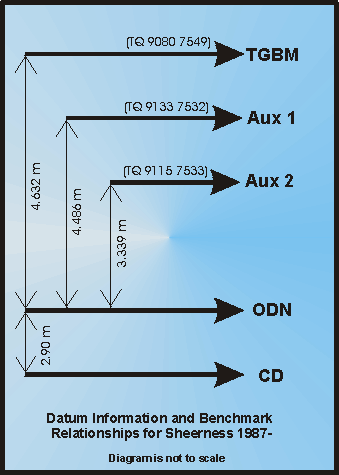
Benchmark Relationships
- TGZ = Chart Datum = 2.90m below ODN
- TGZ = Chart Datum = 7.532m below TGBM
- TGZ = Chart Datum = 7.386m below Aux 1
- TGZ = Chart Datum = 6.239m below Aux 2
Glossary
- TGZ = Tide Gauge Zero
- TGBM = Tide Gauge Benchmark
- Aux = Auxiliary Benchmark
- ODN = Ordnance Datum Newlyn
- CD = Chart Datum
Related Fixed Station activities are detailed in Appendix 1
BODC Quality Control Flags
The following single character qualifying flags may be associated with one or more individual parameters with a data cycle:
| Flag | Description |
|---|---|
| Blank | Unqualified |
| < | Below detection limit |
| > | In excess of quoted value |
| A | Taxonomic flag for affinis (aff.) |
| B | Beginning of CTD Down/Up Cast |
| C | Taxonomic flag for confer (cf.) |
| D | Thermometric depth |
| E | End of CTD Down/Up Cast |
| G | Non-taxonomic biological characteristic uncertainty |
| H | Extrapolated value |
| I | Taxonomic flag for single species (sp.) |
| K | Improbable value - unknown quality control source |
| L | Improbable value - originator's quality control |
| M | Improbable value - BODC quality control |
| N | Null value |
| O | Improbable value - user quality control |
| P | Trace/calm |
| Q | Indeterminate |
| R | Replacement value |
| S | Estimated value |
| T | Interpolated value |
| U | Uncalibrated |
| W | Control value |
| X | Excessive difference |
SeaDataNet Quality Control Flags
The following single character qualifying flags may be associated with one or more individual parameters with a data cycle:
| Flag | Description |
|---|---|
| 0 | no quality control |
| 1 | good value |
| 2 | probably good value |
| 3 | probably bad value |
| 4 | bad value |
| 5 | changed value |
| 6 | value below detection |
| 7 | value in excess |
| 8 | interpolated value |
| 9 | missing value |
| A | value phenomenon uncertain |
| B | nominal value |
| Q | value below limit of quantification |
Appendix 1: Sheerness
Related series for this Fixed Station are presented in the table below. Further information can be found by following the appropriate links.
If you are interested in these series, please be aware we offer a multiple file download service. Should your credentials be insufficient for automatic download, the service also offers a referral to our Enquiries Officer who may be able to negotiate access.
| Series Identifier | Data Category | Start date/time | Start position | Cruise |
|---|---|---|---|---|
| 981700 | Sea surface elevation -unspecified | 1870-01-01 00:00:00 | 51.44223 N, 0.74306 E | Not applicable |
| 981712 | Sea surface elevation -unspecified | 1870-02-01 00:00:00 | 51.44223 N, 0.74306 E | Not applicable |
| 981724 | Sea surface elevation -unspecified | 1870-03-01 00:00:00 | 51.44223 N, 0.74306 E | Not applicable |
| 981736 | Sea surface elevation -unspecified | 1870-04-01 00:00:00 | 51.44223 N, 0.74306 E | Not applicable |
| 981748 | Sea surface elevation -unspecified | 1870-05-01 00:00:00 | 51.44223 N, 0.74306 E | Not applicable |
| 981761 | Sea surface elevation -unspecified | 1870-06-01 00:00:00 | 51.44223 N, 0.74306 E | Not applicable |
| 981773 | Sea surface elevation -unspecified | 1870-07-01 00:00:00 | 51.44223 N, 0.74306 E | Not applicable |
| 981785 | Sea surface elevation -unspecified | 1870-08-01 00:00:00 | 51.44223 N, 0.74306 E | Not applicable |
| 981797 | Sea surface elevation -unspecified | 1870-09-01 00:00:00 | 51.44223 N, 0.74306 E | Not applicable |
| 981804 | Sea surface elevation -unspecified | 1870-10-01 00:00:00 | 51.44223 N, 0.74306 E | Not applicable |
| 981816 | Sea surface elevation -unspecified | 1870-11-01 00:00:00 | 51.44223 N, 0.74306 E | Not applicable |
| 981828 | Sea surface elevation -unspecified | 1870-12-01 00:00:00 | 51.44223 N, 0.74306 E | Not applicable |
| 981841 | Sea surface elevation -unspecified | 1871-01-01 00:00:00 | 51.44223 N, 0.74306 E | Not applicable |
| 981853 | Sea surface elevation -unspecified | 1871-02-01 00:00:00 | 51.44223 N, 0.74306 E | Not applicable |
| 981865 | Sea surface elevation -unspecified | 1871-03-01 00:00:00 | 51.44223 N, 0.74306 E | Not applicable |
| 981877 | Sea surface elevation -unspecified | 1871-04-01 00:00:00 | 51.44223 N, 0.74306 E | Not applicable |
| 981889 | Sea surface elevation -unspecified | 1871-05-01 00:00:00 | 51.44223 N, 0.74306 E | Not applicable |
| 981890 | Sea surface elevation -unspecified | 1871-06-01 00:00:00 | 51.44223 N, 0.74306 E | Not applicable |
| 981908 | Sea surface elevation -unspecified | 1871-07-01 00:00:00 | 51.44223 N, 0.74306 E | Not applicable |
| 981921 | Sea surface elevation -unspecified | 1871-08-01 00:00:00 | 51.44223 N, 0.74306 E | Not applicable |
| 981933 | Sea surface elevation -unspecified | 1871-09-01 00:00:00 | 51.44223 N, 0.74306 E | Not applicable |
| 981945 | Sea surface elevation -unspecified | 1871-10-01 00:00:00 | 51.44223 N, 0.74306 E | Not applicable |
| 981957 | Sea surface elevation -unspecified | 1871-11-01 00:00:00 | 51.44223 N, 0.74306 E | Not applicable |
| 981969 | Sea surface elevation -unspecified | 1871-12-01 00:00:00 | 51.44223 N, 0.74306 E | Not applicable |
| 981970 | Sea surface elevation -unspecified | 1872-01-01 00:00:00 | 51.44223 N, 0.74306 E | Not applicable |
| 981982 | Sea surface elevation -unspecified | 1872-02-01 00:00:00 | 51.44223 N, 0.74306 E | Not applicable |
| 981994 | Sea surface elevation -unspecified | 1872-03-01 00:00:00 | 51.44223 N, 0.74306 E | Not applicable |
| 982008 | Sea surface elevation -unspecified | 1872-04-01 00:00:00 | 51.44223 N, 0.74306 E | Not applicable |
| 982021 | Sea surface elevation -unspecified | 1872-05-01 00:00:00 | 51.44223 N, 0.74306 E | Not applicable |
| 982033 | Sea surface elevation -unspecified | 1872-06-01 00:00:00 | 51.44223 N, 0.74306 E | Not applicable |
| 982045 | Sea surface elevation -unspecified | 1872-07-01 00:00:00 | 51.44223 N, 0.74306 E | Not applicable |
| 982057 | Sea surface elevation -unspecified | 1872-08-01 00:00:00 | 51.44223 N, 0.74306 E | Not applicable |
| 982069 | Sea surface elevation -unspecified | 1872-09-01 00:00:00 | 51.44223 N, 0.74306 E | Not applicable |
| 982070 | Sea surface elevation -unspecified | 1872-10-01 00:00:00 | 51.44223 N, 0.74306 E | Not applicable |
| 982082 | Sea surface elevation -unspecified | 1872-11-01 00:00:00 | 51.44223 N, 0.74306 E | Not applicable |
| 982094 | Sea surface elevation -unspecified | 1872-12-01 00:00:00 | 51.44223 N, 0.74306 E | Not applicable |
| 982101 | Sea surface elevation -unspecified | 1873-01-01 00:00:00 | 51.44223 N, 0.74306 E | Not applicable |
| 982113 | Sea surface elevation -unspecified | 1873-02-01 00:00:00 | 51.44223 N, 0.74306 E | Not applicable |
| 982125 | Sea surface elevation -unspecified | 1873-03-01 00:00:00 | 51.44223 N, 0.74306 E | Not applicable |
| 982137 | Sea surface elevation -unspecified | 1873-04-01 00:00:00 | 51.44223 N, 0.74306 E | Not applicable |
| 982149 | Sea surface elevation -unspecified | 1873-05-01 00:00:00 | 51.44223 N, 0.74306 E | Not applicable |
| 982150 | Sea surface elevation -unspecified | 1873-06-01 00:00:00 | 51.44223 N, 0.74306 E | Not applicable |
| 982162 | Sea surface elevation -unspecified | 1873-07-01 00:00:00 | 51.44223 N, 0.74306 E | Not applicable |
| 982174 | Sea surface elevation -unspecified | 1873-08-01 00:00:00 | 51.44223 N, 0.74306 E | Not applicable |
| 982186 | Sea surface elevation -unspecified | 1873-09-01 00:00:00 | 51.44223 N, 0.74306 E | Not applicable |
| 982198 | Sea surface elevation -unspecified | 1873-10-01 00:00:00 | 51.44223 N, 0.74306 E | Not applicable |
| 982205 | Sea surface elevation -unspecified | 1873-11-01 00:00:00 | 51.44223 N, 0.74306 E | Not applicable |
| 982217 | Sea surface elevation -unspecified | 1873-12-01 00:00:00 | 51.44223 N, 0.74306 E | Not applicable |
| 982229 | Sea surface elevation -unspecified | 1874-01-01 00:00:00 | 51.44223 N, 0.74306 E | Not applicable |
| 982230 | Sea surface elevation -unspecified | 1874-02-01 00:00:00 | 51.44223 N, 0.74306 E | Not applicable |
| 982242 | Sea surface elevation -unspecified | 1874-03-01 00:00:00 | 51.44223 N, 0.74306 E | Not applicable |
| 982254 | Sea surface elevation -unspecified | 1874-04-01 00:00:00 | 51.44223 N, 0.74306 E | Not applicable |
| 982266 | Sea surface elevation -unspecified | 1874-05-01 00:00:00 | 51.44223 N, 0.74306 E | Not applicable |
| 982278 | Sea surface elevation -unspecified | 1874-06-01 00:00:00 | 51.44223 N, 0.74306 E | Not applicable |
| 982291 | Sea surface elevation -unspecified | 1874-07-01 00:00:00 | 51.44223 N, 0.74306 E | Not applicable |
| 982309 | Sea surface elevation -unspecified | 1874-08-01 00:00:00 | 51.44223 N, 0.74306 E | Not applicable |
| 982310 | Sea surface elevation -unspecified | 1874-09-01 00:00:00 | 51.44223 N, 0.74306 E | Not applicable |
| 982322 | Sea surface elevation -unspecified | 1874-10-01 00:00:00 | 51.44223 N, 0.74306 E | Not applicable |
| 982334 | Sea surface elevation -unspecified | 1874-11-01 00:00:00 | 51.44223 N, 0.74306 E | Not applicable |
| 982346 | Sea surface elevation -unspecified | 1874-12-01 00:00:00 | 51.44223 N, 0.74306 E | Not applicable |
| 982358 | Sea surface elevation -unspecified | 1875-01-01 00:00:00 | 51.44223 N, 0.74306 E | Not applicable |
| 982371 | Sea surface elevation -unspecified | 1875-02-01 00:00:00 | 51.44223 N, 0.74306 E | Not applicable |
| 982383 | Sea surface elevation -unspecified | 1875-03-01 00:00:00 | 51.44223 N, 0.74306 E | Not applicable |
| 982395 | Sea surface elevation -unspecified | 1875-04-01 00:00:00 | 51.44223 N, 0.74306 E | Not applicable |
| 982402 | Sea surface elevation -unspecified | 1875-05-01 00:00:00 | 51.44223 N, 0.74306 E | Not applicable |
| 982414 | Sea surface elevation -unspecified | 1875-06-01 00:00:00 | 51.44223 N, 0.74306 E | Not applicable |
| 982426 | Sea surface elevation -unspecified | 1875-07-01 00:00:00 | 51.44223 N, 0.74306 E | Not applicable |
| 982438 | Sea surface elevation -unspecified | 1875-08-01 00:00:00 | 51.44223 N, 0.74306 E | Not applicable |
| 982451 | Sea surface elevation -unspecified | 1875-09-01 00:00:00 | 51.44223 N, 0.74306 E | Not applicable |
| 982463 | Sea surface elevation -unspecified | 1875-10-01 00:00:00 | 51.44223 N, 0.74306 E | Not applicable |
| 982475 | Sea surface elevation -unspecified | 1875-11-01 00:00:00 | 51.44223 N, 0.74306 E | Not applicable |
| 982487 | Sea surface elevation -unspecified | 1875-12-01 00:00:00 | 51.44223 N, 0.74306 E | Not applicable |
| 982499 | Sea surface elevation -unspecified | 1876-01-01 00:00:00 | 51.44223 N, 0.74306 E | Not applicable |
| 982506 | Sea surface elevation -unspecified | 1876-02-01 00:00:00 | 51.44223 N, 0.74306 E | Not applicable |
| 982518 | Sea surface elevation -unspecified | 1876-03-01 00:00:00 | 51.44223 N, 0.74306 E | Not applicable |
| 982531 | Sea surface elevation -unspecified | 1876-04-01 00:00:00 | 51.44223 N, 0.74306 E | Not applicable |
| 982543 | Sea surface elevation -unspecified | 1876-05-01 00:00:00 | 51.44223 N, 0.74306 E | Not applicable |
| 982555 | Sea surface elevation -unspecified | 1876-06-01 00:00:00 | 51.44223 N, 0.74306 E | Not applicable |
| 982567 | Sea surface elevation -unspecified | 1876-07-01 00:00:00 | 51.44223 N, 0.74306 E | Not applicable |
| 982579 | Sea surface elevation -unspecified | 1876-08-01 00:00:00 | 51.44223 N, 0.74306 E | Not applicable |
| 982580 | Sea surface elevation -unspecified | 1876-09-01 00:00:00 | 51.44223 N, 0.74306 E | Not applicable |
| 982592 | Sea surface elevation -unspecified | 1876-10-01 00:00:00 | 51.44223 N, 0.74306 E | Not applicable |
| 982611 | Sea surface elevation -unspecified | 1876-11-01 00:00:00 | 51.44223 N, 0.74306 E | Not applicable |
| 982623 | Sea surface elevation -unspecified | 1876-12-01 00:00:00 | 51.44223 N, 0.74306 E | Not applicable |
| 982635 | Sea surface elevation -unspecified | 1877-01-01 00:00:00 | 51.44223 N, 0.74306 E | Not applicable |
| 982647 | Sea surface elevation -unspecified | 1877-02-01 00:00:00 | 51.44223 N, 0.74306 E | Not applicable |
| 982659 | Sea surface elevation -unspecified | 1877-03-01 00:00:00 | 51.44223 N, 0.74306 E | Not applicable |
| 982660 | Sea surface elevation -unspecified | 1877-04-01 00:00:00 | 51.44223 N, 0.74306 E | Not applicable |
| 982672 | Sea surface elevation -unspecified | 1877-05-01 00:00:00 | 51.44223 N, 0.74306 E | Not applicable |
| 982684 | Sea surface elevation -unspecified | 1877-06-01 00:00:00 | 51.44223 N, 0.74306 E | Not applicable |
| 982696 | Sea surface elevation -unspecified | 1877-07-01 00:00:00 | 51.44223 N, 0.74306 E | Not applicable |
| 982703 | Sea surface elevation -unspecified | 1877-08-01 00:00:00 | 51.44223 N, 0.74306 E | Not applicable |
| 982715 | Sea surface elevation -unspecified | 1877-09-01 00:00:00 | 51.44223 N, 0.74306 E | Not applicable |
| 982727 | Sea surface elevation -unspecified | 1877-10-01 00:00:00 | 51.44223 N, 0.74306 E | Not applicable |
| 982739 | Sea surface elevation -unspecified | 1877-11-01 00:00:00 | 51.44223 N, 0.74306 E | Not applicable |
| 982740 | Sea surface elevation -unspecified | 1877-12-01 00:00:00 | 51.44223 N, 0.74306 E | Not applicable |
| 982752 | Sea surface elevation -unspecified | 1878-01-01 00:00:00 | 51.44223 N, 0.74306 E | Not applicable |
| 982764 | Sea surface elevation -unspecified | 1878-02-01 00:00:00 | 51.44223 N, 0.74306 E | Not applicable |
| 982776 | Sea surface elevation -unspecified | 1878-03-01 00:00:00 | 51.44223 N, 0.74306 E | Not applicable |
| 982788 | Sea surface elevation -unspecified | 1878-04-01 00:00:00 | 51.44223 N, 0.74306 E | Not applicable |
| 982807 | Sea surface elevation -unspecified | 1878-05-01 00:00:00 | 51.44223 N, 0.74306 E | Not applicable |
| 982819 | Sea surface elevation -unspecified | 1878-06-01 00:00:00 | 51.44223 N, 0.74306 E | Not applicable |
| 982820 | Sea surface elevation -unspecified | 1878-07-01 00:00:00 | 51.44223 N, 0.74306 E | Not applicable |
| 982832 | Sea surface elevation -unspecified | 1878-08-01 00:00:00 | 51.44223 N, 0.74306 E | Not applicable |
| 982844 | Sea surface elevation -unspecified | 1878-09-01 00:00:00 | 51.44223 N, 0.74306 E | Not applicable |
| 982856 | Sea surface elevation -unspecified | 1878-10-01 00:00:00 | 51.44223 N, 0.74306 E | Not applicable |
| 982868 | Sea surface elevation -unspecified | 1878-11-01 00:00:00 | 51.44223 N, 0.74306 E | Not applicable |
| 982881 | Sea surface elevation -unspecified | 1878-12-01 00:00:00 | 51.44223 N, 0.74306 E | Not applicable |
| 982893 | Sea surface elevation -unspecified | 1879-01-01 00:00:00 | 51.44223 N, 0.74306 E | Not applicable |
| 982900 | Sea surface elevation -unspecified | 1879-02-01 00:00:00 | 51.44223 N, 0.74306 E | Not applicable |
| 982912 | Sea surface elevation -unspecified | 1879-03-01 00:00:00 | 51.44223 N, 0.74306 E | Not applicable |
| 982924 | Sea surface elevation -unspecified | 1879-04-01 00:00:00 | 51.44223 N, 0.74306 E | Not applicable |
| 982936 | Sea surface elevation -unspecified | 1879-05-01 00:00:00 | 51.44223 N, 0.74306 E | Not applicable |
| 982948 | Sea surface elevation -unspecified | 1879-06-01 00:00:00 | 51.44223 N, 0.74306 E | Not applicable |
| 982961 | Sea surface elevation -unspecified | 1879-07-01 00:00:00 | 51.44223 N, 0.74306 E | Not applicable |
| 982973 | Sea surface elevation -unspecified | 1879-08-01 00:00:00 | 51.44223 N, 0.74306 E | Not applicable |
| 982985 | Sea surface elevation -unspecified | 1879-09-01 00:00:00 | 51.44223 N, 0.74306 E | Not applicable |
| 982997 | Sea surface elevation -unspecified | 1879-10-01 00:00:00 | 51.44223 N, 0.74306 E | Not applicable |
| 983000 | Sea surface elevation -unspecified | 1879-11-01 00:00:00 | 51.44223 N, 0.74306 E | Not applicable |
| 983012 | Sea surface elevation -unspecified | 1879-12-01 00:00:00 | 51.44223 N, 0.74306 E | Not applicable |
| 983024 | Sea surface elevation -unspecified | 1880-01-01 00:00:00 | 51.44223 N, 0.74306 E | Not applicable |
| 983036 | Sea surface elevation -unspecified | 1880-02-01 00:00:00 | 51.44223 N, 0.74306 E | Not applicable |
| 983048 | Sea surface elevation -unspecified | 1880-03-01 00:00:00 | 51.44223 N, 0.74306 E | Not applicable |
| 983061 | Sea surface elevation -unspecified | 1880-04-01 00:00:00 | 51.44223 N, 0.74306 E | Not applicable |
| 983073 | Sea surface elevation -unspecified | 1880-05-01 00:00:00 | 51.44223 N, 0.74306 E | Not applicable |
| 983085 | Sea surface elevation -unspecified | 1880-06-01 00:00:00 | 51.44223 N, 0.74306 E | Not applicable |
| 983097 | Sea surface elevation -unspecified | 1880-07-01 00:00:00 | 51.44223 N, 0.74306 E | Not applicable |
| 983104 | Sea surface elevation -unspecified | 1880-08-01 00:00:00 | 51.44223 N, 0.74306 E | Not applicable |
| 983116 | Sea surface elevation -unspecified | 1880-09-01 00:00:00 | 51.44223 N, 0.74306 E | Not applicable |
| 983128 | Sea surface elevation -unspecified | 1880-10-01 00:00:00 | 51.44223 N, 0.74306 E | Not applicable |
| 983141 | Sea surface elevation -unspecified | 1880-11-01 00:00:00 | 51.44223 N, 0.74306 E | Not applicable |
| 983153 | Sea surface elevation -unspecified | 1880-12-01 00:00:00 | 51.44223 N, 0.74306 E | Not applicable |
| 983165 | Sea surface elevation -unspecified | 1881-01-01 00:00:00 | 51.44223 N, 0.74306 E | Not applicable |
| 983177 | Sea surface elevation -unspecified | 1881-02-01 00:00:00 | 51.44223 N, 0.74306 E | Not applicable |
| 983189 | Sea surface elevation -unspecified | 1881-03-01 00:00:00 | 51.44223 N, 0.74306 E | Not applicable |
| 983190 | Sea surface elevation -unspecified | 1881-04-01 00:00:00 | 51.44223 N, 0.74306 E | Not applicable |
| 983208 | Sea surface elevation -unspecified | 1881-05-01 00:00:00 | 51.44223 N, 0.74306 E | Not applicable |
| 983221 | Sea surface elevation -unspecified | 1881-06-01 00:00:00 | 51.44223 N, 0.74306 E | Not applicable |
| 983233 | Sea surface elevation -unspecified | 1881-07-01 00:00:00 | 51.44223 N, 0.74306 E | Not applicable |
| 983245 | Sea surface elevation -unspecified | 1881-08-01 00:00:00 | 51.44223 N, 0.74306 E | Not applicable |
| 983257 | Sea surface elevation -unspecified | 1881-09-01 00:00:00 | 51.44223 N, 0.74306 E | Not applicable |
| 983269 | Sea surface elevation -unspecified | 1881-10-01 00:00:00 | 51.44223 N, 0.74306 E | Not applicable |
| 983270 | Sea surface elevation -unspecified | 1881-11-01 00:00:00 | 51.44223 N, 0.74306 E | Not applicable |
| 983282 | Sea surface elevation -unspecified | 1881-12-01 00:00:00 | 51.44223 N, 0.74306 E | Not applicable |
| 983294 | Sea surface elevation -unspecified | 1882-07-01 00:00:00 | 51.44223 N, 0.74306 E | Not applicable |
| 983301 | Sea surface elevation -unspecified | 1882-08-01 00:00:00 | 51.44223 N, 0.74306 E | Not applicable |
| 983313 | Sea surface elevation -unspecified | 1882-09-01 00:00:00 | 51.44223 N, 0.74306 E | Not applicable |
| 983325 | Sea surface elevation -unspecified | 1882-10-01 00:00:00 | 51.44223 N, 0.74306 E | Not applicable |
| 983337 | Sea surface elevation -unspecified | 1882-11-01 00:00:00 | 51.44223 N, 0.74306 E | Not applicable |
| 983349 | Sea surface elevation -unspecified | 1882-12-01 00:00:00 | 51.44223 N, 0.74306 E | Not applicable |
| 983350 | Sea surface elevation -unspecified | 1883-01-01 00:00:00 | 51.44223 N, 0.74306 E | Not applicable |
| 983362 | Sea surface elevation -unspecified | 1883-02-01 00:00:00 | 51.44223 N, 0.74306 E | Not applicable |
| 983374 | Sea surface elevation -unspecified | 1883-03-01 00:00:00 | 51.44223 N, 0.74306 E | Not applicable |
| 983386 | Sea surface elevation -unspecified | 1883-04-01 00:00:00 | 51.44223 N, 0.74306 E | Not applicable |
| 983398 | Sea surface elevation -unspecified | 1883-05-01 00:00:00 | 51.44223 N, 0.74306 E | Not applicable |
| 983405 | Sea surface elevation -unspecified | 1883-06-01 00:00:00 | 51.44223 N, 0.74306 E | Not applicable |
| 983417 | Sea surface elevation -unspecified | 1883-07-01 00:00:00 | 51.44223 N, 0.74306 E | Not applicable |
| 983429 | Sea surface elevation -unspecified | 1883-08-01 00:00:00 | 51.44223 N, 0.74306 E | Not applicable |
| 983430 | Sea surface elevation -unspecified | 1883-09-01 00:00:00 | 51.44223 N, 0.74306 E | Not applicable |
| 983442 | Sea surface elevation -unspecified | 1883-10-01 00:00:00 | 51.44223 N, 0.74306 E | Not applicable |
| 983454 | Sea surface elevation -unspecified | 1883-11-01 00:00:00 | 51.44223 N, 0.74306 E | Not applicable |
| 983466 | Sea surface elevation -unspecified | 1883-12-01 00:00:00 | 51.44223 N, 0.74306 E | Not applicable |
| 983478 | Sea surface elevation -unspecified | 1884-01-01 00:00:00 | 51.44223 N, 0.74306 E | Not applicable |
| 983491 | Sea surface elevation -unspecified | 1884-02-01 00:00:00 | 51.44223 N, 0.74306 E | Not applicable |
| 983509 | Sea surface elevation -unspecified | 1884-03-01 00:00:00 | 51.44223 N, 0.74306 E | Not applicable |
| 983510 | Sea surface elevation -unspecified | 1884-04-01 00:00:00 | 51.44223 N, 0.74306 E | Not applicable |
| 983522 | Sea surface elevation -unspecified | 1884-05-01 00:00:00 | 51.44223 N, 0.74306 E | Not applicable |
| 983534 | Sea surface elevation -unspecified | 1884-06-01 00:00:00 | 51.44223 N, 0.74306 E | Not applicable |
| 983546 | Sea surface elevation -unspecified | 1884-07-01 00:00:00 | 51.44223 N, 0.74306 E | Not applicable |
| 983558 | Sea surface elevation -unspecified | 1884-08-01 00:00:00 | 51.44223 N, 0.74306 E | Not applicable |
| 983571 | Sea surface elevation -unspecified | 1884-09-01 00:00:00 | 51.44223 N, 0.74306 E | Not applicable |
| 983583 | Sea surface elevation -unspecified | 1884-10-01 00:00:00 | 51.44223 N, 0.74306 E | Not applicable |
| 983595 | Sea surface elevation -unspecified | 1884-11-01 00:00:00 | 51.44223 N, 0.74306 E | Not applicable |
| 983602 | Sea surface elevation -unspecified | 1884-12-01 00:00:00 | 51.44223 N, 0.74306 E | Not applicable |
| 983614 | Sea surface elevation -unspecified | 1885-01-01 00:00:00 | 51.44223 N, 0.74306 E | Not applicable |
| 983626 | Sea surface elevation -unspecified | 1885-02-01 00:00:00 | 51.44223 N, 0.74306 E | Not applicable |
| 983638 | Sea surface elevation -unspecified | 1885-03-01 00:00:00 | 51.44223 N, 0.74306 E | Not applicable |
| 983651 | Sea surface elevation -unspecified | 1885-04-01 00:00:00 | 51.44223 N, 0.74306 E | Not applicable |
| 983663 | Sea surface elevation -unspecified | 1885-05-01 00:00:00 | 51.44223 N, 0.74306 E | Not applicable |
| 983675 | Sea surface elevation -unspecified | 1885-06-01 00:00:00 | 51.44223 N, 0.74306 E | Not applicable |
| 983687 | Sea surface elevation -unspecified | 1885-07-01 00:00:00 | 51.44223 N, 0.74306 E | Not applicable |
| 983699 | Sea surface elevation -unspecified | 1885-08-01 00:00:00 | 51.44223 N, 0.74306 E | Not applicable |
| 983706 | Sea surface elevation -unspecified | 1885-09-01 00:00:00 | 51.44223 N, 0.74306 E | Not applicable |
| 983718 | Sea surface elevation -unspecified | 1885-10-01 00:00:00 | 51.44223 N, 0.74306 E | Not applicable |
| 983731 | Sea surface elevation -unspecified | 1885-11-01 00:00:00 | 51.44223 N, 0.74306 E | Not applicable |
| 983743 | Sea surface elevation -unspecified | 1885-12-01 00:00:00 | 51.44223 N, 0.74306 E | Not applicable |
| 983755 | Sea surface elevation -unspecified | 1886-01-01 00:00:00 | 51.44223 N, 0.74306 E | Not applicable |
| 983767 | Sea surface elevation -unspecified | 1886-02-01 00:00:00 | 51.44223 N, 0.74306 E | Not applicable |
| 983779 | Sea surface elevation -unspecified | 1886-03-01 00:00:00 | 51.44223 N, 0.74306 E | Not applicable |
| 983780 | Sea surface elevation -unspecified | 1886-04-01 00:00:00 | 51.44223 N, 0.74306 E | Not applicable |
| 983792 | Sea surface elevation -unspecified | 1886-05-01 00:00:00 | 51.44223 N, 0.74306 E | Not applicable |
| 983811 | Sea surface elevation -unspecified | 1886-06-01 00:00:00 | 51.44223 N, 0.74306 E | Not applicable |
| 983823 | Sea surface elevation -unspecified | 1886-07-01 00:00:00 | 51.44223 N, 0.74306 E | Not applicable |
| 983835 | Sea surface elevation -unspecified | 1886-08-01 00:00:00 | 51.44223 N, 0.74306 E | Not applicable |
| 983847 | Sea surface elevation -unspecified | 1886-09-01 00:00:00 | 51.44223 N, 0.74306 E | Not applicable |
| 983859 | Sea surface elevation -unspecified | 1886-10-01 00:00:00 | 51.44223 N, 0.74306 E | Not applicable |
| 983860 | Sea surface elevation -unspecified | 1886-11-01 00:00:00 | 51.44223 N, 0.74306 E | Not applicable |
| 983872 | Sea surface elevation -unspecified | 1886-12-01 00:00:00 | 51.44223 N, 0.74306 E | Not applicable |
| 983884 | Sea surface elevation -unspecified | 1887-01-01 00:00:00 | 51.44223 N, 0.74306 E | Not applicable |
| 983896 | Sea surface elevation -unspecified | 1887-02-01 00:00:00 | 51.44223 N, 0.74306 E | Not applicable |
| 983903 | Sea surface elevation -unspecified | 1887-03-01 00:00:00 | 51.44223 N, 0.74306 E | Not applicable |
| 983915 | Sea surface elevation -unspecified | 1887-04-01 00:00:00 | 51.44223 N, 0.74306 E | Not applicable |
| 983927 | Sea surface elevation -unspecified | 1887-05-01 00:00:00 | 51.44223 N, 0.74306 E | Not applicable |
| 983939 | Sea surface elevation -unspecified | 1887-06-01 00:00:00 | 51.44223 N, 0.74306 E | Not applicable |
| 983940 | Sea surface elevation -unspecified | 1887-07-01 00:00:00 | 51.44223 N, 0.74306 E | Not applicable |
| 983952 | Sea surface elevation -unspecified | 1887-08-01 00:00:00 | 51.44223 N, 0.74306 E | Not applicable |
| 983964 | Sea surface elevation -unspecified | 1887-09-01 00:00:00 | 51.44223 N, 0.74306 E | Not applicable |
| 983976 | Sea surface elevation -unspecified | 1887-10-01 00:00:00 | 51.44223 N, 0.74306 E | Not applicable |
| 983988 | Sea surface elevation -unspecified | 1887-11-01 00:00:00 | 51.44223 N, 0.74306 E | Not applicable |
| 984003 | Sea surface elevation -unspecified | 1887-12-01 00:00:00 | 51.44223 N, 0.74306 E | Not applicable |
| 984015 | Sea surface elevation -unspecified | 1888-01-01 00:00:00 | 51.44223 N, 0.74306 E | Not applicable |
| 984027 | Sea surface elevation -unspecified | 1888-02-01 00:00:00 | 51.44223 N, 0.74306 E | Not applicable |
| 984039 | Sea surface elevation -unspecified | 1888-03-01 00:00:00 | 51.44223 N, 0.74306 E | Not applicable |
| 984040 | Sea surface elevation -unspecified | 1888-04-01 00:00:00 | 51.44223 N, 0.74306 E | Not applicable |
| 984052 | Sea surface elevation -unspecified | 1888-05-01 00:00:00 | 51.44223 N, 0.74306 E | Not applicable |
| 984064 | Sea surface elevation -unspecified | 1888-06-01 00:00:00 | 51.44223 N, 0.74306 E | Not applicable |
| 984076 | Sea surface elevation -unspecified | 1888-07-01 00:00:00 | 51.44223 N, 0.74306 E | Not applicable |
| 984088 | Sea surface elevation -unspecified | 1888-08-01 00:00:00 | 51.44223 N, 0.74306 E | Not applicable |
| 984107 | Sea surface elevation -unspecified | 1888-09-01 00:00:00 | 51.44223 N, 0.74306 E | Not applicable |
| 984119 | Sea surface elevation -unspecified | 1888-10-01 00:00:00 | 51.44223 N, 0.74306 E | Not applicable |
| 984120 | Sea surface elevation -unspecified | 1888-11-01 00:00:00 | 51.44223 N, 0.74306 E | Not applicable |
| 984132 | Sea surface elevation -unspecified | 1888-12-01 00:00:00 | 51.44223 N, 0.74306 E | Not applicable |
| 979418 | Sea surface elevation -unspecified | 1889-01-01 00:00:00 | 51.44223 N, 0.74306 E | Not applicable |
| 979431 | Sea surface elevation -unspecified | 1889-02-01 00:00:00 | 51.44223 N, 0.74306 E | Not applicable |
| 979443 | Sea surface elevation -unspecified | 1889-03-01 00:00:00 | 51.44223 N, 0.74306 E | Not applicable |
| 979455 | Sea surface elevation -unspecified | 1889-04-01 00:00:00 | 51.44223 N, 0.74306 E | Not applicable |
| 979467 | Sea surface elevation -unspecified | 1889-05-01 00:00:00 | 51.44223 N, 0.74306 E | Not applicable |
| 979479 | Sea surface elevation -unspecified | 1889-06-01 00:00:00 | 51.44223 N, 0.74306 E | Not applicable |
| 979480 | Sea surface elevation -unspecified | 1889-07-01 00:00:00 | 51.44223 N, 0.74306 E | Not applicable |
| 979492 | Sea surface elevation -unspecified | 1889-08-01 00:00:00 | 51.44223 N, 0.74306 E | Not applicable |
| 979511 | Sea surface elevation -unspecified | 1889-09-01 00:00:00 | 51.44223 N, 0.74306 E | Not applicable |
| 979523 | Sea surface elevation -unspecified | 1889-10-01 00:00:00 | 51.44223 N, 0.74306 E | Not applicable |
| 979535 | Sea surface elevation -unspecified | 1889-11-01 00:00:00 | 51.44223 N, 0.74306 E | Not applicable |
| 979547 | Sea surface elevation -unspecified | 1889-12-01 00:00:00 | 51.44223 N, 0.74306 E | Not applicable |
| 979559 | Sea surface elevation -unspecified | 1890-01-01 00:00:00 | 51.44223 N, 0.74306 E | Not applicable |
| 979560 | Sea surface elevation -unspecified | 1890-02-01 00:00:00 | 51.44223 N, 0.74306 E | Not applicable |
| 979572 | Sea surface elevation -unspecified | 1890-03-01 00:00:00 | 51.44223 N, 0.74306 E | Not applicable |
| 979584 | Sea surface elevation -unspecified | 1890-04-01 00:00:00 | 51.44223 N, 0.74306 E | Not applicable |
| 979596 | Sea surface elevation -unspecified | 1890-05-01 00:00:00 | 51.44223 N, 0.74306 E | Not applicable |
| 979603 | Sea surface elevation -unspecified | 1890-06-01 00:00:00 | 51.44223 N, 0.74306 E | Not applicable |
| 979615 | Sea surface elevation -unspecified | 1890-07-01 00:00:00 | 51.44223 N, 0.74306 E | Not applicable |
| 979627 | Sea surface elevation -unspecified | 1890-08-01 00:00:00 | 51.44223 N, 0.74306 E | Not applicable |
| 979639 | Sea surface elevation -unspecified | 1890-09-01 00:00:00 | 51.44223 N, 0.74306 E | Not applicable |
| 979640 | Sea surface elevation -unspecified | 1890-10-01 00:00:00 | 51.44223 N, 0.74306 E | Not applicable |
| 979652 | Sea surface elevation -unspecified | 1890-11-01 00:00:00 | 51.44223 N, 0.74306 E | Not applicable |
| 979664 | Sea surface elevation -unspecified | 1890-12-01 00:00:00 | 51.44223 N, 0.74306 E | Not applicable |
| 979676 | Sea surface elevation -unspecified | 1891-01-01 00:00:00 | 51.44223 N, 0.74306 E | Not applicable |
| 979688 | Sea surface elevation -unspecified | 1891-02-01 00:00:00 | 51.44223 N, 0.74306 E | Not applicable |
| 979707 | Sea surface elevation -unspecified | 1891-03-01 00:00:00 | 51.44223 N, 0.74306 E | Not applicable |
| 979719 | Sea surface elevation -unspecified | 1891-04-01 00:00:00 | 51.44223 N, 0.74306 E | Not applicable |
| 979720 | Sea surface elevation -unspecified | 1891-05-01 00:00:00 | 51.44223 N, 0.74306 E | Not applicable |
| 979732 | Sea surface elevation -unspecified | 1891-06-01 00:00:00 | 51.44223 N, 0.74306 E | Not applicable |
| 979744 | Sea surface elevation -unspecified | 1891-07-01 00:00:00 | 51.44223 N, 0.74306 E | Not applicable |
| 979756 | Sea surface elevation -unspecified | 1891-08-01 00:00:00 | 51.44223 N, 0.74306 E | Not applicable |
| 979768 | Sea surface elevation -unspecified | 1891-09-01 00:00:00 | 51.44223 N, 0.74306 E | Not applicable |
| 979781 | Sea surface elevation -unspecified | 1891-10-01 00:00:00 | 51.44223 N, 0.74306 E | Not applicable |
| 979793 | Sea surface elevation -unspecified | 1891-11-01 00:00:00 | 51.44223 N, 0.74306 E | Not applicable |
| 979800 | Sea surface elevation -unspecified | 1891-12-01 00:00:00 | 51.44223 N, 0.74306 E | Not applicable |
| 979812 | Sea surface elevation -unspecified | 1892-01-01 00:00:00 | 51.44223 N, 0.74306 E | Not applicable |
| 979824 | Sea surface elevation -unspecified | 1892-02-01 00:00:00 | 51.44223 N, 0.74306 E | Not applicable |
| 979836 | Sea surface elevation -unspecified | 1892-03-01 00:00:00 | 51.44223 N, 0.74306 E | Not applicable |
| 979848 | Sea surface elevation -unspecified | 1892-04-01 00:00:00 | 51.44223 N, 0.74306 E | Not applicable |
| 979861 | Sea surface elevation -unspecified | 1892-05-01 00:00:00 | 51.44223 N, 0.74306 E | Not applicable |
| 979873 | Sea surface elevation -unspecified | 1892-06-01 00:00:00 | 51.44223 N, 0.74306 E | Not applicable |
| 979885 | Sea surface elevation -unspecified | 1892-07-01 00:00:00 | 51.44223 N, 0.74306 E | Not applicable |
| 979897 | Sea surface elevation -unspecified | 1892-08-01 00:00:00 | 51.44223 N, 0.74306 E | Not applicable |
| 979904 | Sea surface elevation -unspecified | 1892-09-01 00:00:00 | 51.44223 N, 0.74306 E | Not applicable |
| 979916 | Sea surface elevation -unspecified | 1892-10-01 00:00:00 | 51.44223 N, 0.74306 E | Not applicable |
| 979928 | Sea surface elevation -unspecified | 1892-11-01 00:00:00 | 51.44223 N, 0.74306 E | Not applicable |
| 979941 | Sea surface elevation -unspecified | 1892-12-01 00:00:00 | 51.44223 N, 0.74306 E | Not applicable |
| 979953 | Sea surface elevation -unspecified | 1893-01-01 00:00:00 | 51.44223 N, 0.74306 E | Not applicable |
| 979965 | Sea surface elevation -unspecified | 1893-02-01 00:00:00 | 51.44223 N, 0.74306 E | Not applicable |
| 979977 | Sea surface elevation -unspecified | 1893-03-01 00:00:00 | 51.44223 N, 0.74306 E | Not applicable |
| 979989 | Sea surface elevation -unspecified | 1893-04-01 00:00:00 | 51.44223 N, 0.74306 E | Not applicable |
| 979990 | Sea surface elevation -unspecified | 1893-05-01 00:00:00 | 51.44223 N, 0.74306 E | Not applicable |
| 980002 | Sea surface elevation -unspecified | 1893-06-01 00:00:00 | 51.44223 N, 0.74306 E | Not applicable |
| 980014 | Sea surface elevation -unspecified | 1893-07-01 00:00:00 | 51.44223 N, 0.74306 E | Not applicable |
| 980026 | Sea surface elevation -unspecified | 1893-08-01 00:00:00 | 51.44223 N, 0.74306 E | Not applicable |
| 980038 | Sea surface elevation -unspecified | 1893-09-01 00:00:00 | 51.44223 N, 0.74306 E | Not applicable |
| 980051 | Sea surface elevation -unspecified | 1893-10-01 00:00:00 | 51.44223 N, 0.74306 E | Not applicable |
| 980063 | Sea surface elevation -unspecified | 1893-11-01 00:00:00 | 51.44223 N, 0.74306 E | Not applicable |
| 980075 | Sea surface elevation -unspecified | 1893-12-01 00:00:00 | 51.44223 N, 0.74306 E | Not applicable |
| 980087 | Sea surface elevation -unspecified | 1894-01-01 00:00:00 | 51.44223 N, 0.74306 E | Not applicable |
| 980099 | Sea surface elevation -unspecified | 1894-02-01 00:00:00 | 51.44223 N, 0.74306 E | Not applicable |
| 980106 | Sea surface elevation -unspecified | 1894-03-01 00:00:00 | 51.44223 N, 0.74306 E | Not applicable |
| 980118 | Sea surface elevation -unspecified | 1894-04-01 00:00:00 | 51.44223 N, 0.74306 E | Not applicable |
| 980131 | Sea surface elevation -unspecified | 1894-05-01 00:00:00 | 51.44223 N, 0.74306 E | Not applicable |
| 980143 | Sea surface elevation -unspecified | 1894-06-01 00:00:00 | 51.44223 N, 0.74306 E | Not applicable |
| 980155 | Sea surface elevation -unspecified | 1894-07-01 00:00:00 | 51.44223 N, 0.74306 E | Not applicable |
| 980167 | Sea surface elevation -unspecified | 1894-08-01 00:00:00 | 51.44223 N, 0.74306 E | Not applicable |
| 980179 | Sea surface elevation -unspecified | 1894-09-01 00:00:00 | 51.44223 N, 0.74306 E | Not applicable |
| 980180 | Sea surface elevation -unspecified | 1894-10-01 00:00:00 | 51.44223 N, 0.74306 E | Not applicable |
| 980192 | Sea surface elevation -unspecified | 1929-12-01 00:00:00 | 51.44223 N, 0.74306 E | Not applicable |
| 980211 | Sea surface elevation -unspecified | 1930-01-01 00:00:00 | 51.44223 N, 0.74306 E | Not applicable |
| 980223 | Sea surface elevation -unspecified | 1930-02-01 00:00:00 | 51.44223 N, 0.74306 E | Not applicable |
| 980235 | Sea surface elevation -unspecified | 1930-03-01 00:00:00 | 51.44223 N, 0.74306 E | Not applicable |
| 980247 | Sea surface elevation -unspecified | 1930-04-01 00:00:00 | 51.44223 N, 0.74306 E | Not applicable |
| 980259 | Sea surface elevation -unspecified | 1930-05-01 00:00:00 | 51.44223 N, 0.74306 E | Not applicable |
| 980260 | Sea surface elevation -unspecified | 1930-06-01 00:00:00 | 51.44223 N, 0.74306 E | Not applicable |
| 980272 | Sea surface elevation -unspecified | 1930-07-01 00:00:00 | 51.44223 N, 0.74306 E | Not applicable |
| 980284 | Sea surface elevation -unspecified | 1930-08-01 00:00:00 | 51.44223 N, 0.74306 E | Not applicable |
| 980296 | Sea surface elevation -unspecified | 1930-09-01 00:00:00 | 51.44223 N, 0.74306 E | Not applicable |
| 980303 | Sea surface elevation -unspecified | 1930-10-01 00:00:00 | 51.44223 N, 0.74306 E | Not applicable |
| 980315 | Sea surface elevation -unspecified | 1930-11-01 00:00:00 | 51.44223 N, 0.74306 E | Not applicable |
| 980327 | Sea surface elevation -unspecified | 1930-12-01 00:00:00 | 51.44223 N, 0.74306 E | Not applicable |
| 980339 | Sea surface elevation -unspecified | 1931-01-01 00:00:00 | 51.44223 N, 0.74306 E | Not applicable |
| 980340 | Sea surface elevation -unspecified | 1931-02-01 00:00:00 | 51.44223 N, 0.74306 E | Not applicable |
| 980352 | Sea surface elevation -unspecified | 1931-03-01 00:00:00 | 51.44223 N, 0.74306 E | Not applicable |
| 980364 | Sea surface elevation -unspecified | 1931-04-01 00:00:00 | 51.44223 N, 0.74306 E | Not applicable |
| 980376 | Sea surface elevation -unspecified | 1931-05-01 00:00:00 | 51.44223 N, 0.74306 E | Not applicable |
| 980388 | Sea surface elevation -unspecified | 1931-06-01 00:00:00 | 51.44223 N, 0.74306 E | Not applicable |
| 980407 | Sea surface elevation -unspecified | 1931-07-01 00:00:00 | 51.44223 N, 0.74306 E | Not applicable |
| 980419 | Sea surface elevation -unspecified | 1931-08-01 00:00:00 | 51.44223 N, 0.74306 E | Not applicable |
| 980420 | Sea surface elevation -unspecified | 1931-09-01 00:00:00 | 51.44223 N, 0.74306 E | Not applicable |
| 980432 | Sea surface elevation -unspecified | 1931-10-01 00:00:00 | 51.44223 N, 0.74306 E | Not applicable |
| 980444 | Sea surface elevation -unspecified | 1931-11-01 00:00:00 | 51.44223 N, 0.74306 E | Not applicable |
| 980456 | Sea surface elevation -unspecified | 1931-12-01 00:00:00 | 51.44223 N, 0.74306 E | Not applicable |
| 980468 | Sea surface elevation -unspecified | 1932-01-01 00:00:00 | 51.44223 N, 0.74306 E | Not applicable |
| 980481 | Sea surface elevation -unspecified | 1932-02-01 00:00:00 | 51.44223 N, 0.74306 E | Not applicable |
| 980493 | Sea surface elevation -unspecified | 1932-03-01 00:00:00 | 51.44223 N, 0.74306 E | Not applicable |
| 980500 | Sea surface elevation -unspecified | 1932-04-01 00:00:00 | 51.44223 N, 0.74306 E | Not applicable |
| 980512 | Sea surface elevation -unspecified | 1932-05-01 00:00:00 | 51.44223 N, 0.74306 E | Not applicable |
| 980524 | Sea surface elevation -unspecified | 1932-06-01 00:00:00 | 51.44223 N, 0.74306 E | Not applicable |
| 980536 | Sea surface elevation -unspecified | 1932-07-01 00:00:00 | 51.44223 N, 0.74306 E | Not applicable |
| 980548 | Sea surface elevation -unspecified | 1932-08-01 00:00:00 | 51.44223 N, 0.74306 E | Not applicable |
| 980561 | Sea surface elevation -unspecified | 1932-09-01 00:00:00 | 51.44223 N, 0.74306 E | Not applicable |
| 980573 | Sea surface elevation -unspecified | 1932-10-01 00:00:00 | 51.44223 N, 0.74306 E | Not applicable |
| 980585 | Sea surface elevation -unspecified | 1932-11-01 00:00:00 | 51.44223 N, 0.74306 E | Not applicable |
| 980597 | Sea surface elevation -unspecified | 1932-12-01 00:00:00 | 51.44223 N, 0.74306 E | Not applicable |
| 980604 | Sea surface elevation -unspecified | 1933-01-01 00:00:00 | 51.44223 N, 0.74306 E | Not applicable |
| 980616 | Sea surface elevation -unspecified | 1933-02-01 00:00:00 | 51.44223 N, 0.74306 E | Not applicable |
| 980628 | Sea surface elevation -unspecified | 1933-03-01 00:00:00 | 51.44223 N, 0.74306 E | Not applicable |
| 980641 | Sea surface elevation -unspecified | 1933-04-01 00:00:00 | 51.44223 N, 0.74306 E | Not applicable |
| 980653 | Sea surface elevation -unspecified | 1933-05-01 00:00:00 | 51.44223 N, 0.74306 E | Not applicable |
| 980665 | Sea surface elevation -unspecified | 1933-06-01 00:00:00 | 51.44223 N, 0.74306 E | Not applicable |
| 980677 | Sea surface elevation -unspecified | 1933-07-01 00:00:00 | 51.44223 N, 0.74306 E | Not applicable |
| 980689 | Sea surface elevation -unspecified | 1933-08-01 00:00:00 | 51.44223 N, 0.74306 E | Not applicable |
| 980690 | Sea surface elevation -unspecified | 1933-09-01 00:00:00 | 51.44223 N, 0.74306 E | Not applicable |
| 980708 | Sea surface elevation -unspecified | 1933-10-01 00:00:00 | 51.44223 N, 0.74306 E | Not applicable |
| 980721 | Sea surface elevation -unspecified | 1933-11-01 00:00:00 | 51.44223 N, 0.74306 E | Not applicable |
| 980733 | Sea surface elevation -unspecified | 1933-12-01 00:00:00 | 51.44223 N, 0.74306 E | Not applicable |
| 980745 | Sea surface elevation -unspecified | 1934-01-01 00:00:00 | 51.44223 N, 0.74306 E | Not applicable |
| 980757 | Sea surface elevation -unspecified | 1934-02-01 00:00:00 | 51.44223 N, 0.74306 E | Not applicable |
| 980769 | Sea surface elevation -unspecified | 1934-03-01 00:00:00 | 51.44223 N, 0.74306 E | Not applicable |
| 980770 | Sea surface elevation -unspecified | 1934-04-01 00:00:00 | 51.44223 N, 0.74306 E | Not applicable |
| 980782 | Sea surface elevation -unspecified | 1934-05-01 00:00:00 | 51.44223 N, 0.74306 E | Not applicable |
| 980794 | Sea surface elevation -unspecified | 1934-06-01 00:00:00 | 51.44223 N, 0.74306 E | Not applicable |
| 980801 | Sea surface elevation -unspecified | 1934-07-01 00:00:00 | 51.44223 N, 0.74306 E | Not applicable |
| 980813 | Sea surface elevation -unspecified | 1934-08-01 00:00:00 | 51.44223 N, 0.74306 E | Not applicable |
| 980825 | Sea surface elevation -unspecified | 1934-09-01 00:00:00 | 51.44223 N, 0.74306 E | Not applicable |
| 980837 | Sea surface elevation -unspecified | 1934-10-01 00:00:00 | 51.44223 N, 0.74306 E | Not applicable |
| 980849 | Sea surface elevation -unspecified | 1934-11-01 00:00:00 | 51.44223 N, 0.74306 E | Not applicable |
| 980850 | Sea surface elevation -unspecified | 1934-12-01 00:00:00 | 51.44223 N, 0.74306 E | Not applicable |
| 980862 | Sea surface elevation -unspecified | 1935-01-01 00:00:00 | 51.44223 N, 0.74306 E | Not applicable |
| 980874 | Sea surface elevation -unspecified | 1935-02-01 00:00:00 | 51.44223 N, 0.74306 E | Not applicable |
| 980886 | Sea surface elevation -unspecified | 1935-03-01 00:00:00 | 51.44223 N, 0.74306 E | Not applicable |
| 980898 | Sea surface elevation -unspecified | 1935-04-01 00:00:00 | 51.44223 N, 0.74306 E | Not applicable |
| 980905 | Sea surface elevation -unspecified | 1935-05-01 00:00:00 | 51.44223 N, 0.74306 E | Not applicable |
| 980917 | Sea surface elevation -unspecified | 1935-06-01 00:00:00 | 51.44223 N, 0.74306 E | Not applicable |
| 980929 | Sea surface elevation -unspecified | 1935-07-01 00:00:00 | 51.44223 N, 0.74306 E | Not applicable |
| 980930 | Sea surface elevation -unspecified | 1935-08-01 00:00:00 | 51.44223 N, 0.74306 E | Not applicable |
| 980942 | Sea surface elevation -unspecified | 1935-09-01 00:00:00 | 51.44223 N, 0.74306 E | Not applicable |
| 980954 | Sea surface elevation -unspecified | 1935-10-01 00:00:00 | 51.44223 N, 0.74306 E | Not applicable |
| 980966 | Sea surface elevation -unspecified | 1935-11-01 00:00:00 | 51.44223 N, 0.74306 E | Not applicable |
| 980978 | Sea surface elevation -unspecified | 1935-12-01 00:00:00 | 51.44223 N, 0.74306 E | Not applicable |
| 980991 | Sea surface elevation -unspecified | 1936-01-01 00:00:00 | 51.44223 N, 0.74306 E | Not applicable |
| 981005 | Sea surface elevation -unspecified | 1936-02-01 00:00:00 | 51.44223 N, 0.74306 E | Not applicable |
| 981017 | Sea surface elevation -unspecified | 1936-03-01 00:00:00 | 51.44223 N, 0.74306 E | Not applicable |
| 981029 | Sea surface elevation -unspecified | 1936-04-01 00:00:00 | 51.44223 N, 0.74306 E | Not applicable |
| 981030 | Sea surface elevation -unspecified | 1936-05-01 00:00:00 | 51.44223 N, 0.74306 E | Not applicable |
| 981042 | Sea surface elevation -unspecified | 1936-06-01 00:00:00 | 51.44223 N, 0.74306 E | Not applicable |
| 981054 | Sea surface elevation -unspecified | 1936-07-01 00:00:00 | 51.44223 N, 0.74306 E | Not applicable |
| 981066 | Sea surface elevation -unspecified | 1936-08-01 00:00:00 | 51.44223 N, 0.74306 E | Not applicable |
| 981078 | Sea surface elevation -unspecified | 1936-09-01 00:00:00 | 51.44223 N, 0.74306 E | Not applicable |
| 981091 | Sea surface elevation -unspecified | 1936-10-01 00:00:00 | 51.44223 N, 0.74306 E | Not applicable |
| 981109 | Sea surface elevation -unspecified | 1936-11-01 00:00:00 | 51.44223 N, 0.74306 E | Not applicable |
| 981110 | Sea surface elevation -unspecified | 1936-12-01 00:00:00 | 51.44223 N, 0.74306 E | Not applicable |
| 981122 | Sea surface elevation -unspecified | 1937-01-01 00:00:00 | 51.44223 N, 0.74306 E | Not applicable |
| 981134 | Sea surface elevation -unspecified | 1937-02-01 00:00:00 | 51.44223 N, 0.74306 E | Not applicable |
| 981146 | Sea surface elevation -unspecified | 1937-03-01 00:00:00 | 51.44223 N, 0.74306 E | Not applicable |
| 981158 | Sea surface elevation -unspecified | 1937-04-01 00:00:00 | 51.44223 N, 0.74306 E | Not applicable |
| 981171 | Sea surface elevation -unspecified | 1937-05-01 00:00:00 | 51.44223 N, 0.74306 E | Not applicable |
| 981183 | Sea surface elevation -unspecified | 1937-06-01 00:00:00 | 51.44223 N, 0.74306 E | Not applicable |
| 981195 | Sea surface elevation -unspecified | 1937-07-01 00:00:00 | 51.44223 N, 0.74306 E | Not applicable |
| 981202 | Sea surface elevation -unspecified | 1937-08-01 00:00:00 | 51.44223 N, 0.74306 E | Not applicable |
| 981214 | Sea surface elevation -unspecified | 1937-09-01 00:00:00 | 51.44223 N, 0.74306 E | Not applicable |
| 981226 | Sea surface elevation -unspecified | 1937-10-01 00:00:00 | 51.44223 N, 0.74306 E | Not applicable |
| 981238 | Sea surface elevation -unspecified | 1937-11-01 00:00:00 | 51.44223 N, 0.74306 E | Not applicable |
| 981263 | Sea surface elevation -unspecified | 1938-01-01 00:00:00 | 51.44223 N, 0.74306 E | Not applicable |
| 981275 | Sea surface elevation -unspecified | 1938-02-01 00:00:00 | 51.44223 N, 0.74306 E | Not applicable |
| 981287 | Sea surface elevation -unspecified | 1938-03-01 00:00:00 | 51.44223 N, 0.74306 E | Not applicable |
| 981299 | Sea surface elevation -unspecified | 1938-04-01 00:00:00 | 51.44223 N, 0.74306 E | Not applicable |
| 981306 | Sea surface elevation -unspecified | 1938-05-01 00:00:00 | 51.44223 N, 0.74306 E | Not applicable |
| 981318 | Sea surface elevation -unspecified | 1938-06-01 00:00:00 | 51.44223 N, 0.74306 E | Not applicable |
| 981331 | Sea surface elevation -unspecified | 1938-07-01 00:00:00 | 51.44223 N, 0.74306 E | Not applicable |
| 981343 | Sea surface elevation -unspecified | 1938-08-01 00:00:00 | 51.44223 N, 0.74306 E | Not applicable |
| 981355 | Sea surface elevation -unspecified | 1938-09-01 00:00:00 | 51.44223 N, 0.74306 E | Not applicable |
| 981367 | Sea surface elevation -unspecified | 1938-10-01 00:00:00 | 51.44223 N, 0.74306 E | Not applicable |
| 981379 | Sea surface elevation -unspecified | 1938-11-01 00:00:00 | 51.44223 N, 0.74306 E | Not applicable |
| 981380 | Sea surface elevation -unspecified | 1938-12-01 00:00:00 | 51.44223 N, 0.74306 E | Not applicable |
| 981392 | Sea surface elevation -unspecified | 1939-01-01 00:00:00 | 51.44223 N, 0.74306 E | Not applicable |
| 981411 | Sea surface elevation -unspecified | 1939-02-01 00:00:00 | 51.44223 N, 0.74306 E | Not applicable |
| 981423 | Sea surface elevation -unspecified | 1939-03-01 00:00:00 | 51.44223 N, 0.74306 E | Not applicable |
| 981435 | Sea surface elevation -unspecified | 1939-04-01 00:00:00 | 51.44223 N, 0.74306 E | Not applicable |
| 981447 | Sea surface elevation -unspecified | 1939-05-01 00:00:00 | 51.44223 N, 0.74306 E | Not applicable |
| 981459 | Sea surface elevation -unspecified | 1939-06-01 00:00:00 | 51.44223 N, 0.74306 E | Not applicable |
| 981460 | Sea surface elevation -unspecified | 1939-07-01 00:00:00 | 51.44223 N, 0.74306 E | Not applicable |
| 981472 | Sea surface elevation -unspecified | 1939-08-01 00:00:00 | 51.44223 N, 0.74306 E | Not applicable |
| 981484 | Sea surface elevation -unspecified | 1939-09-01 00:00:00 | 51.44223 N, 0.74306 E | Not applicable |
| 981496 | Sea surface elevation -unspecified | 1939-10-01 00:00:00 | 51.44223 N, 0.74306 E | Not applicable |
| 981503 | Sea surface elevation -unspecified | 1939-11-01 00:00:00 | 51.44223 N, 0.74306 E | Not applicable |
| 981515 | Sea surface elevation -unspecified | 1939-12-01 00:00:00 | 51.44223 N, 0.74306 E | Not applicable |
| 981527 | Sea surface elevation -unspecified | 1940-01-01 00:00:00 | 51.44223 N, 0.74306 E | Not applicable |
| 981539 | Sea surface elevation -unspecified | 1940-02-01 00:00:00 | 51.44223 N, 0.74306 E | Not applicable |
| 981540 | Sea surface elevation -unspecified | 1940-03-01 00:00:00 | 51.44223 N, 0.74306 E | Not applicable |
| 981552 | Sea surface elevation -unspecified | 1940-04-01 00:00:00 | 51.44223 N, 0.74306 E | Not applicable |
| 981564 | Sea surface elevation -unspecified | 1940-05-01 00:00:00 | 51.44223 N, 0.74306 E | Not applicable |
| 981576 | Sea surface elevation -unspecified | 1940-06-02 00:00:00 | 51.44223 N, 0.74306 E | Not applicable |
| 981588 | Sea surface elevation -unspecified | 1940-07-01 00:00:00 | 51.44223 N, 0.74306 E | Not applicable |
| 981607 | Sea surface elevation -unspecified | 1940-08-01 00:00:00 | 51.44223 N, 0.74306 E | Not applicable |
| 981619 | Sea surface elevation -unspecified | 1940-09-01 00:00:00 | 51.44223 N, 0.74306 E | Not applicable |
| 981620 | Sea surface elevation -unspecified | 1940-10-01 00:00:00 | 51.44223 N, 0.74306 E | Not applicable |
| 981632 | Sea surface elevation -unspecified | 1940-11-01 00:00:00 | 51.44223 N, 0.74306 E | Not applicable |
| 981644 | Sea surface elevation -unspecified | 1940-12-01 00:00:00 | 51.44223 N, 0.74306 E | Not applicable |
| 981656 | Sea surface elevation -unspecified | 1941-01-01 00:00:00 | 51.44223 N, 0.74306 E | Not applicable |
| 981668 | Sea surface elevation -unspecified | 1941-02-01 00:00:00 | 51.44223 N, 0.74306 E | Not applicable |
| 981681 | Sea surface elevation -unspecified | 1941-03-01 00:00:00 | 51.44223 N, 0.74306 E | Not applicable |
| 981693 | Sea surface elevation -unspecified | 1941-04-01 00:00:00 | 51.44223 N, 0.74306 E | Not applicable |
| 304538 | Sea surface elevation -unspecified | 1952-01-01 00:00:00 | 51.44223 N, 0.74306 E | Not applicable |
| 304551 | Sea surface elevation -unspecified | 1958-01-01 00:00:00 | 51.44223 N, 0.74306 E | Not applicable |
| 39209 | Sea surface elevation -unspecified | 1965-01-01 00:00:00 | 51.44564 N, 0.74344 E | Not applicable |
| 39210 | Sea surface elevation -unspecified | 1966-01-01 00:00:00 | 51.44564 N, 0.74344 E | Not applicable |
| 39234 | Sea surface elevation -unspecified | 1967-01-01 00:00:00 | 51.44564 N, 0.74344 E | Not applicable |
| 39222 | Sea surface elevation -unspecified | 1968-01-01 00:00:00 | 51.44564 N, 0.74344 E | Not applicable |
| 39246 | Sea surface elevation -unspecified | 1969-05-05 10:00:00 | 51.44564 N, 0.74344 E | Not applicable |
| 44236 | Sea surface elevation -unspecified | 1970-01-01 00:00:00 | 51.44564 N, 0.74344 E | Not applicable |
| 44248 | Sea surface elevation -unspecified | 1971-01-01 00:00:00 | 51.44564 N, 0.74344 E | Not applicable |
| 44261 | Sea surface elevation -unspecified | 1972-01-01 00:00:00 | 51.44564 N, 0.74344 E | Not applicable |
| 44212 | Sea surface elevation -unspecified | 1973-01-01 00:00:00 | 51.44564 N, 0.74344 E | Not applicable |
| 44224 | Sea surface elevation -unspecified | 1974-01-01 00:00:00 | 51.44564 N, 0.74344 E | Not applicable |
| 195041 | Sea surface elevation -unspecified | 1975-01-01 00:00:00 | 51.44564 N, 0.74344 E | Not applicable |
| 240587 | Sea surface elevation -unspecified | 1980-09-03 20:00:00 | 51.44564 N, 0.74344 E | Not applicable |
| 240599 | Sea surface elevation -unspecified | 1981-01-01 00:00:00 | 51.44564 N, 0.74344 E | Not applicable |
| 240606 | Sea surface elevation -unspecified | 1982-01-01 00:00:00 | 51.44564 N, 0.74344 E | Not applicable |
| 240575 | Sea surface elevation -unspecified | 1983-01-01 00:00:00 | 51.44564 N, 0.74344 E | Not applicable |
| 240563 | Sea surface elevation -unspecified | 1983-07-20 21:00:00 | 51.44564 N, 0.74344 E | Not applicable |
| 50506 | Sea surface elevation -unspecified | 1984-01-01 00:00:00 | 51.44564 N, 0.74344 E | Not applicable |
| 195004 | Sea surface elevation -unspecified | 1985-01-01 00:00:00 | 51.44564 N, 0.74344 E | Not applicable |
| 195016 | Sea surface elevation -unspecified | 1986-01-01 00:00:00 | 51.44564 N, 0.74344 E | Not applicable |
| 195065 | Sea surface elevation -unspecified | 1986-10-24 21:00:00 | 51.44564 N, 0.74344 E | Not applicable |
| 195077 | Sea surface elevation -unspecified | 1987-01-01 00:00:00 | 51.44564 N, 0.74344 E | Not applicable |
| 240618 | Sea surface elevation -unspecified | 1988-01-01 00:00:00 | 51.44564 N, 0.74344 E | Not applicable |
| 311812 | Sea surface elevation -unspecified | 1989-01-01 00:00:00 | 51.44564 N, 0.74344 E | Not applicable |
| 243942 | Sea surface elevation -unspecified | 1990-01-01 00:00:00 | 51.44564 N, 0.74344 E | Not applicable |
| 311824 | Sea surface elevation -unspecified | 1991-01-01 00:00:00 | 51.44564 N, 0.74344 E | Not applicable |
| 304563 | Sea surface elevation -unspecified | 1992-01-01 00:00:00 | 51.44564 N, 0.74344 E | Not applicable |
| 540112 | Sea surface elevation -unspecified | 1993-01-01 00:14:59 | 51.44564 N, 0.74344 E | Not applicable |
| 540124 | Sea surface elevation -unspecified | 1994-01-01 00:14:59 | 51.44564 N, 0.74344 E | Not applicable |
| 540136 | Sea surface elevation -unspecified | 1995-01-01 00:00:00 | 51.44564 N, 0.74344 E | Not applicable |
| 540148 | Sea surface elevation -unspecified | 1996-01-01 00:14:59 | 51.44564 N, 0.74344 E | Not applicable |
| 540161 | Sea surface elevation -unspecified | 1997-01-01 00:14:59 | 51.44564 N, 0.74344 E | Not applicable |
| 540173 | Sea surface elevation -unspecified | 1998-01-01 00:14:59 | 51.44564 N, 0.74344 E | Not applicable |
| 540185 | Sea surface elevation -unspecified | 1999-01-01 00:14:59 | 51.44564 N, 0.74344 E | Not applicable |
| 565105 | Sea surface elevation -unspecified | 2000-01-01 00:14:59 | 51.44564 N, 0.74344 E | Not applicable |
| 578503 | Sea surface elevation -unspecified | 2001-01-01 00:00:00 | 51.44564 N, 0.74344 E | Not applicable |
| 593628 | Sea surface elevation -unspecified | 2002-01-01 00:00:00 | 51.44564 N, 0.74344 E | Not applicable |
| 626200 | Sea surface elevation -unspecified | 2003-01-01 00:00:00 | 51.44564 N, 0.74344 E | Not applicable |
| 644323 | Sea surface elevation -unspecified | 2004-01-01 00:00:00 | 51.44564 N, 0.74344 E | Not applicable |
| 663357 | Sea surface elevation -unspecified | 2005-01-01 00:00:00 | 51.44564 N, 0.74344 E | Not applicable |
| 697760 | Sea surface elevation -unspecified | 2006-01-01 00:00:00 | 51.44564 N, 0.74344 E | Not applicable |
| 846657 | Sea surface elevation -unspecified | 2007-01-01 00:00:00 | 51.44564 N, 0.74344 E | Not applicable |
| 847138 | Sea surface elevation -unspecified | 2008-01-01 00:00:00 | 51.44564 N, 0.74344 E | Not applicable |
| 1111739 | Sea surface elevation -unspecified | 2009-01-01 00:00:00 | 51.44564 N, 0.74344 E | Not applicable |
| 1111740 | Sea surface elevation -unspecified | 2010-01-01 00:00:00 | 51.44564 N, 0.74344 E | Not applicable |
| 1111752 | Sea surface elevation -unspecified | 2011-01-01 00:00:00 | 51.44564 N, 0.74344 E | Not applicable |
