BODC Cruise Metadata Report for RRS Challenger (74CH) cruise CH7/79
Introduction
This report collates information from the BODC cruise inventory and oceanographic databases. It presents
- Cruise Inventory Information
- A summary of BODC data holdings for the cruise from the
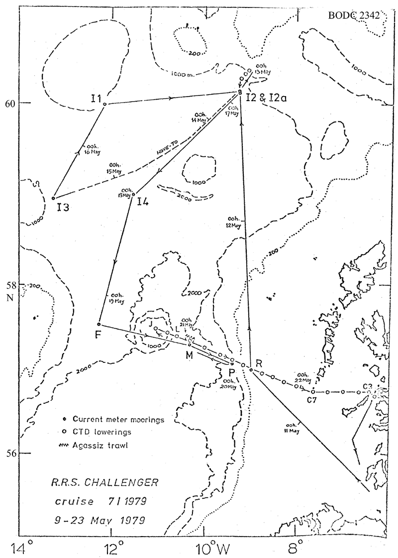
- References - including cruise tracks and cruise reports
Cruise Inventory Information
| Long name | RRS Challenger (74CH) cruise CH7/79 |
|---|---|
| Short name | CH7/79 |
| Objectives and Narrative |
The objectives of this cruise were:
(1) Service the current meter mooring at 57N, 9W and deploy moorings at three stations on the Rockall via Anton Dohrn Seamount section. Accomplished, but one recovered current meter has failed due to leakage. (2) Service IOS moorings in the Rockall Channel. Two of four moorings were recovered. (3) Work the Rockall via Anton Dohrn Seamount (Ellett Line) CTD section. Only part of the section from the seamount eastwards could be worked due to time lost through mooring recovery problems. (4) Work additional CTD sections in the northern Rockall Channel. A section across the Cirolana Deep was started but not finished due to technical problems with the CTD. (5) Collect large-volume surface water sample for radiocaesium analysis from Scottish shelf stations. Accomplished with CTD profiles on all but one station. (6) Obtain epibenthic sled samples at the SMBA permanent station (54 deg 40 min N, 12 deg 16 min W). Not possible due to poor weather and time lost through mooring recovery problems. (7) Obtain deep plankton samples at the SMBA permanent section using the rectangular mid-water trawl. Not possible due to poor weather and time lost through mooring recovery problems. (8) Obtain Assagiz trawl samples between the Anton Dohrn Seamount and the St Kilda continental slope. One good sample was obtained. |
| Ship | RRS Challenger |
| Departure Port | Ardrossan, United Kingdom |
| Departure Date | 1979-05-10 |
| Arrival Port | Ardrossan, United Kingdom |
| Arrival Date | 1979-05-23 |
| Principal Scientist(s) | David J Ellett (Scottish Marine Biological Association) |
| Responsible Organisation | Scottish Marine Biological Association |
| Associated Project(s) | |
| IHB Sea Areas Visited | North East Atlantic Ocean (limit 40W) |
| Marsden Squares Visited | 181;466/181;467/181;468/181;469/181;499/182;350/182;370/182;371 |
| Work Area Description | |
| Unable to lookup cruise bounds at this time | |
| Work Area Bounding Polygon | |
| Southern Limit | unknown |
| Northern Limit | unknown |
| Western Limit | unknown |
| Eastern Limit | unknown |
Cruise Inventory Datasets
| Physical oceanography | |
|---|---|
| CTD stations |
Quantity:
number of stations =
22
Description: salinity noisy |
| Current meters |
Quantity:
number of stations =
4
Description: numbers of meters on the 4 SMBA stations are 4,4,4 and 2, respectively |
| Current meters |
Quantity:
number of stations =
5
Description: |
| Water bottle stations |
Quantity:
number of stations =
40
Description: S surface only |
| Chemical oceanography | |
| Radioactivity |
Quantity:
number of samples =
10
Description: water samples for radio-caesium monitoring. |
| Biology and fisheries | |
| Zoobenthos |
Quantity:
number of hauls =
1
Description: agassiz trawl haul. |
Cruise Inventory Mooring/Buoy Operations
No information on datasets is currently available
Summary of BODC Data Holdings for the Cruise
National Oceanographic Database
Summary
| # Series | Instrument Description | Parameters |
|---|---|---|
| 22 | CTD/STD cast |
Salinity of the water column Temperature of the water column Vertical spatial coordinates |
Note: Parameter terms are taken from the BODC Parameter Discovery Vocabulary XML (SKOS)
Full List
| BODC Reference | Instrument Description | Date/Time | Location | |
|---|---|---|---|---|
| 98627 | CTD/STD cast | 1979-05-13 00:20Z | 60° 19' N, 9° 7' W | Click for more |
| 98639 | CTD/STD cast | 1979-05-13 01:30Z | 60° 17' N, 9° 10' W | Click for more |
| 98640 | CTD/STD cast | 1979-05-13 03:03Z | 60° 16' N, 9° 13' W | Click for more |
| 98652 | CTD/STD cast | 1979-05-20 17:09Z | 57° 27' N, 11° 4' W | Click for more |
| 98664 | CTD/STD cast | 1979-05-20 18:53Z | 57° 24' N, 10° 52' W | Click for more |
| 98676 | CTD/STD cast | 1979-05-20 20:28Z | 57° 22' N, 10° 39' W | Click for more |
| 98688 | CTD/STD cast | 1979-05-21 06:50Z | 57° 18' N, 10° 23' W | Click for more |
| 98707 | CTD/STD cast | 1979-05-21 09:30Z | 57° 13' N, 10° 3' W | Click for more |
| 98719 | CTD/STD cast | 1979-05-21 12:10Z | 57° 9' N, 9° 42' W | Click for more |
| 98720 | CTD/STD cast | 1979-05-21 14:22Z | 57° 6' N, 9° 25' W | Click for more |
| 98732 | CTD/STD cast | 1979-05-21 16:00Z | 57° 3' N, 9° 13' W | Click for more |
| 98744 | CTD/STD cast | 1979-05-21 17:30Z | 57° 0' N, 8° 59' W | Click for more |
| 98756 | CTD/STD cast | 1979-05-21 18:40Z | 56° 57' N, 8° 46' W | Click for more |
| 98768 | CTD/STD cast | 1979-05-21 20:18Z | 56° 52' N, 8° 30' W | Click for more |
| 98781 | CTD/STD cast | 1979-05-21 21:33Z | 56° 51' N, 8° 19' W | Click for more |
| 98793 | CTD/STD cast | 1979-05-21 23:22Z | 56° 46' N, 8° 0' W | Click for more |
| 98800 | CTD/STD cast | 1979-05-22 01:00Z | 56° 43' N, 7° 40' W | Click for more |
| 98812 | CTD/STD cast | 1979-05-22 02:48Z | 56° 43' N, 7° 19' W | Click for more |
| 98824 | CTD/STD cast | 1979-05-22 04:25Z | 56° 43' N, 7° 0' W | Click for more |
| 98836 | CTD/STD cast | 1979-05-22 05:46Z | 56° 44' N, 6° 45' W | Click for more |
| 98848 | CTD/STD cast | 1979-05-22 07:10Z | 56° 43' N, 6° 27' W | Click for more |
| 98861 | CTD/STD cast | 1979-05-22 08:35Z | 56° 43' N, 6° 16' W | Click for more |
Project Database
No data currently held for this cruise in the BODC Project Database
