BODC Cruise Metadata Report for RRS Challenger (74CH) cruise CH13/79
Introduction
This report collates information from the BODC cruise inventory and oceanographic databases. It presents
- Cruise Inventory Information
- A summary of BODC data holdings for the cruise from the
- References - including cruise tracks and cruise reports
Cruise Inventory Information
| Long name | RRS Challenger (74CH) cruise CH13/79 |
|---|---|
| Short name | CH13/79 |
| Objectives and Narrative |
The objectives of this cruise were:
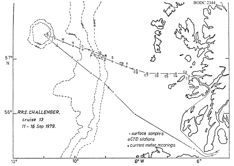
(1) To service the shelf current meter mooring at 57N, 9W and recover the slope current meter mooring at 57 deg 6 min N, 9 deg 24 min W. Accomplished. (2) To work the eastern portion of the Rockall via Anton Dohrn Seamount (Ellett Line) CTD section. Stations K to T worked, covering from the slope of the seamount to the outer Hebridean continental shelf. (3) To work shelf CTD sections to the west of the Hebrides. Not done due to poor weather and lack of time. (4) Collect large volume surface water samples for radiocaesium analysis with CTD profiles on the sampling stations. Accomplished with CTD profiles on nine of the ten stations. |
| Ship | RRS Challenger |
| Departure Port | Ardrossan, United Kingdom |
| Departure Date | 1979-09-11 |
| Arrival Port | Ardrossan, United Kingdom |
| Arrival Date | 1979-09-16 |
| Principal Scientist(s) | David J Ellett (Scottish Marine Biological Association) |
| Responsible Organisation | Scottish Marine Biological Association |
| Associated Project(s) | |
| IHB Sea Areas Visited | North East Atlantic Ocean (limit 40W) |
| Marsden Squares Visited | 181/182 |
| Work Area Description | |
| Unable to lookup cruise bounds at this time | |
| Work Area Bounding Polygon | |
| Southern Limit | unknown |
| Northern Limit | unknown |
| Western Limit | unknown |
| Eastern Limit | unknown |
Cruise Inventory Datasets
| Physical oceanography | |
|---|---|
| CTD stations |
Quantity:
number of stations =
18
Description: 1 T only noisy salinity where max. cast depth >1000m |
| Current meters |
Quantity:
number of stations =
2
Description: 2x79 and 4x117 days |
| Water bottle stations |
Quantity:
number of stations =
20
Description: S surface only |
| Chemical oceanography | |
| Radioactivity |
Quantity:
number of samples =
10
Description: water samples for radio-caesium monitoring. |
Cruise Inventory Mooring/Buoy Operations
No information on datasets is currently available
Summary of BODC Data Holdings for the Cruise
National Oceanographic Database
Summary
| # Series | Instrument Description | Parameters |
|---|---|---|
| 18 | CTD/STD cast |
Salinity of the water column Temperature of the water column Vertical spatial coordinates |
Note: Parameter terms are taken from the BODC Parameter Discovery Vocabulary XML (SKOS)
Full List
| BODC Reference | Instrument Description | Date/Time | Location | |
|---|---|---|---|---|
| 95783 | CTD/STD cast | 1979-09-13 08:05Z | 56° 41' N, 6° 16' W | Click for more |
| 95795 | CTD/STD cast | 1979-09-13 09:25Z | 56° 43' N, 6° 27' W | Click for more |
| 95802 | CTD/STD cast | 1979-09-13 11:00Z | 56° 43' N, 6° 45' W | Click for more |
| 95814 | CTD/STD cast | 1979-09-13 12:45Z | 56° 44' N, 7° 0' W | Click for more |
| 95826 | CTD/STD cast | 1979-09-13 14:40Z | 56° 43' N, 7° 19' W | Click for more |
| 95838 | CTD/STD cast | 1979-09-13 16:40Z | 56° 43' N, 7° 40' W | Click for more |
| 95851 | CTD/STD cast | 1979-09-13 18:41Z | 56° 46' N, 8° 0' W | Click for more |
| 95863 | CTD/STD cast | 1979-09-13 21:02Z | 56° 51' N, 8° 19' W | Click for more |
| 95875 | CTD/STD cast | 1979-09-13 22:42Z | 56° 52' N, 8° 30' W | Click for more |
| 95887 | CTD/STD cast | 1979-09-14 01:50Z | 56° 55' N, 8° 46' W | Click for more |
| 95899 | CTD/STD cast | 1979-09-14 02:40Z | 56° 58' N, 8° 57' W | Click for more |
| 95906 | CTD/STD cast | 1979-09-14 04:44Z | 57° 3' N, 9° 12' W | Click for more |
| 95918 | CTD/STD cast | 1979-09-14 06:22Z | 57° 5' N, 9° 23' W | Click for more |
| 95931 | CTD/STD cast | 1979-09-14 18:53Z | 57° 9' N, 9° 41' W | Click for more |
| 95943 | CTD/STD cast | 1979-09-14 21:45Z | 57° 13' N, 10° 3' W | Click for more |
| 95955 | CTD/STD cast | 1979-09-15 00:05Z | 57° 16' N, 10° 22' W | Click for more |
| 95967 | CTD/STD cast | 1979-09-15 02:45Z | 57° 22' N, 10° 39' W | Click for more |
| 95979 | CTD/STD cast | 1979-09-15 05:30Z | 57° 23' N, 10° 51' W | Click for more |
Project Database
No data currently held for this cruise in the BODC Project Database
